Birkett Mire

Settlement in Cumberland Allerdale

England

Birkett Mire

Low Rigg from the south Looking across from the north end of High Rigg. The Skiddaw range is in cloud in the background.
Low Rigg from the south Credit: Ian Taylor

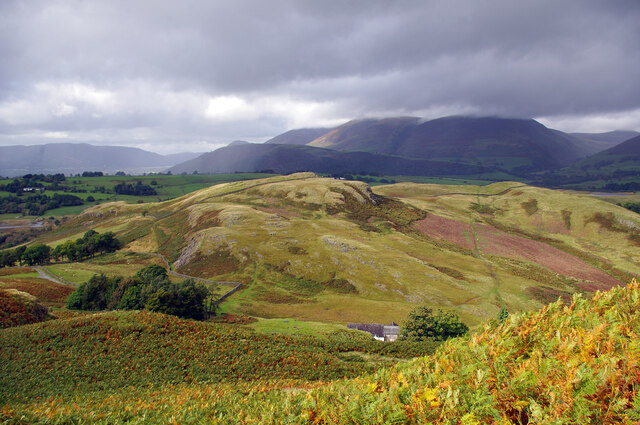
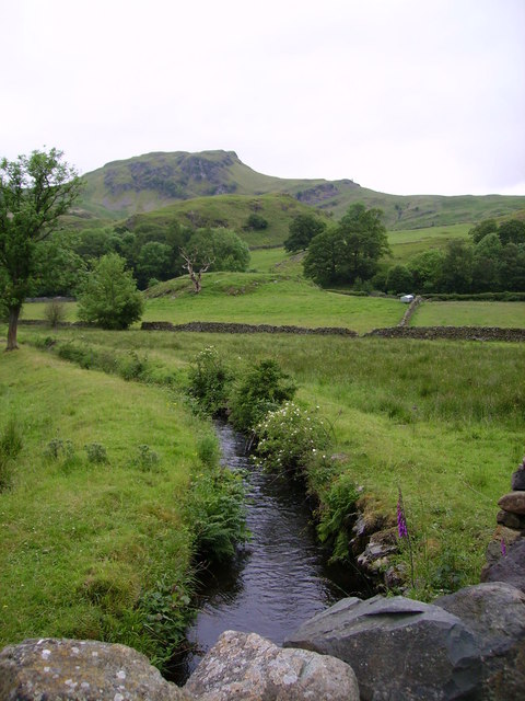
Birkett Mire is a vast moorland located in the county of Cumberland, in the northwest region of England. Situated within the picturesque Lake District National Park, it covers an extensive area of approximately 10 square miles, making it one of the largest moors in the region.

The moorland is characterized by its unique and diverse ecosystem, comprising of heather-covered hills, marshy areas, and peat bogs. Birkett Mire is home to a variety of plant and animal species, including rare birds such as the hen harrier and short-eared owl, as well as several species of mosses and lichens that thrive in the damp conditions.

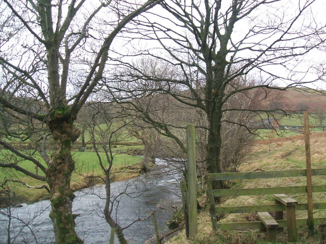
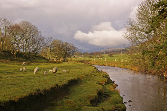
The landscape of Birkett Mire offers breathtaking views, with rolling hills and rugged terrain stretching as far as the eye can see. The moorland is intersected by numerous streams and small rivers that flow into nearby lakes, contributing to the overall beauty of the area.

Historically, Birkett Mire has been used for grazing sheep and has played a significant role in the local agricultural industry. Its peat has also been harvested for fuel in the past, although this practice has significantly diminished in recent years due to conservation efforts.

Today, Birkett Mire attracts visitors who are drawn to its untouched natural beauty and the opportunity to explore the vast open space it offers. Hiking, birdwatching, and photography are popular activities in the area, allowing visitors to immerse themselves in the tranquility and stunning vistas that Birkett Mire has to offer.

If you have any feedback on the listing, please let us know in the comments section below.

Birkett Mire Images

Images are sourced within 2km of 54.606432/-3.0697291 or Grid Reference NY3124. Thanks to Geograph Open Source API. All images are credited.

Low Rigg from the south Looking across from the north end of High Rigg. The Skiddaw range is in cloud in the background.
Low Rigg from the south
Looking across from the north end of High Rigg. The Skiddaw range is in cloud in the background.
Outcrop on Low Rigg Looking towards the fields near Castlerigg. The stone circle is at centre right in the furthest field (in line with the top of Latrigg).
Outcrop on Low Rigg
Looking towards the fields near Castlerigg. The stone circle is at centre right in the furthest field (in line with the top of Latrigg).
Benchmark on Railway Bridge near Threlkeld Benchmark description <span class="nowrap"><a title="https://www.bench-marks.org.uk/bm171401" rel="nofollow ugc noopener" href="https://www.bench-marks.org.uk/bm171401">Link</a><img style="margin-left:2px;" alt="External link" title="External link - shift click to open in new window" src="https://s1.geograph.org.uk/img/external.png" width="10" height="10"/></span>
Benchmark on Railway Bridge near Threlkeld
Benchmark description LinkExternal link
Pivot Benchmark Downfield Bridge near Threlkeld Benchmark description <span class="nowrap"><a title="https://www.bench-marks.org.uk/bm171400" rel="nofollow ugc noopener" href="https://www.bench-marks.org.uk/bm171400">Link</a><img style="margin-left:2px;" alt="External link" title="External link - shift click to open in new window" src="https://s1.geograph.org.uk/img/external.png" width="10" height="10"/></span>
Pivot Benchmark Downfield Bridge near Threlkeld
Benchmark description LinkExternal link
Marchlyn at Threlkeld Visiting Avonside 0-4-0T Marchlyn is seen at Threlkeld Quarry & Mining Museum during their steam gala.
Marchlyn at Threlkeld
Visiting Avonside 0-4-0T Marchlyn is seen at Threlkeld Quarry & Mining Museum during their steam gala.
Ogwen at Threlkeld Visiting Avonside 0-4-0T Ogwen is seen at Threlkeld Quarry & Mining Museum during their steam gala.
Ogwen at Threlkeld
Visiting Avonside 0-4-0T Ogwen is seen at Threlkeld Quarry & Mining Museum during their steam gala.
View from Threlkeld Quarry top The cloud-covered mountain in Blencathra, in the middle foreground is the under-construction extension of the railway at the Quarry & Mining Museum.
View from Threlkeld Quarry top
The cloud-covered mountain in Blencathra, in the middle foreground is the under-construction extension of the railway at the Quarry & Mining Museum.
Threlkeld Quarry gala Visiting Avonside 0-4-0T locomotives Marchlyn and Ogwen are seen in the quarry during the Threlkeld Quarry & Mining Museum's steam gala.
Threlkeld Quarry gala
Visiting Avonside 0-4-0T locomotives Marchlyn and Ogwen are seen in the quarry during the Threlkeld Quarry & Mining Museum's steam gala.
Threlkeld Quarry gala Visiting Avonside 0-4-0T locomotives Marchlyn and Ogwen are seen at Threlkeld Quarry & Mining Museum during their steam gala.
Threlkeld Quarry gala
Visiting Avonside 0-4-0T locomotives Marchlyn and Ogwen are seen at Threlkeld Quarry & Mining Museum during their steam gala.
Threlkeld Quarry gala Visiting Avonside 0-4-0T locomotives Marchlyn and Ogwen, together with resident Bagnall 0-4-0ST Sir Tom, are seen at Threlkeld Quarry & Mining Museum during their steam gala.
Threlkeld Quarry gala
Visiting Avonside 0-4-0T locomotives Marchlyn and Ogwen, together with resident Bagnall 0-4-0ST Sir Tom, are seen at Threlkeld Quarry & Mining Museum during their steam gala.
Old quarry machines at Threlkeld Quarry Museum
Shed at Threlkeld Quarry & Mining Museum
Ogwen at Threlkeld Visiting Avonside 0-4-0T locomotive Ogwen is seen at Threlkeld Quarry & Mining Museum during their steam gala.
Ogwen at Threlkeld
Visiting Avonside 0-4-0T locomotive Ogwen is seen at Threlkeld Quarry & Mining Museum during their steam gala.
Grab buckets at Threlkeld Quarry & Mining Museum
Old quarry machines at Threlkeld Quarry Museum
Marchlyn at Threlkeld Visiting Avonside 0-4-0T Marchlyn climbs the bank at Threlkeld during the Quarry & Mining Museum's steam gala.
Marchlyn at Threlkeld
Visiting Avonside 0-4-0T Marchlyn climbs the bank at Threlkeld during the Quarry & Mining Museum's steam gala.
Ogwen and Marchlyn at Threlkeld Visiting Avonside 0-4-0T locomotives Ogwen and Marchlyn approach the top station during the Quarry & Mining Museum's steam gala. On this run, Marchlyn had stalled on the bank just short of the summit and Ogwen had to come to the rescue.
Ogwen and Marchlyn at Threlkeld
Visiting Avonside 0-4-0T locomotives Ogwen and Marchlyn approach the top station during the Quarry & Mining Museum's steam gala. On this run, Marchlyn had stalled on the bank just short of the summit and Ogwen had to come to the rescue.
Show me another place!

Birkett Mire is located at Grid Ref: NY3124 (Lat: 54.606432, Lng: -3.0697291)

Administrative County: Cumbria

District: Allerdale

Police Authority: Cumbria

What 3 Words

///postings.scribble.enveloped. Near Keswick, Cumbria

Related Wikis

St. John's Beck

St. John's Beck is a river in the Lake District of Cumbria, England. The beck has its beginning as an outflow of Thirlmere, whence it flows northwards...

River Glenderamackin

The River Glenderamackin, the Glendermackin or Glendermackin Beck is a watercourse in Cumbria, England. It is a headstream of the Greta. The river rises...

Naddle Beck

Naddle Beck is a minor river of Cumbria, England. Rising beneath Dodd Crag, Naddle Beck flows northward to meet the River Greta. The major tributary of...

Threlkeld railway station

Threlkeld railway station was situated on the Cockermouth, Keswick and Penrith Railway between Penrith and Cockermouth in Cumbria, England. The station...

Nearby Amenities

Located within 500m of 54.606432,-3.0697291
Post Box
Post Box Type: wall
Ref: CA12 264
Lat/Long: 54.608841/-3.0734791
Barrier: cattle_grid
Lat/Long: 54.608384/-3.0747908
Moss Dikes
Place: locality
Source Name: OS_OpenData_StreetView
Lat/Long: 54.606867/-3.0685169
Power: pole
Lat/Long: 54.6085668/-3.0725212
Power: pole
Lat/Long: 54.608264/-3.0719626
Power: pole
Lat/Long: 54.6078638/-3.0708858
Power: pole
Lat/Long: 54.6074005/-3.0696108
Power: pole
Lat/Long: 54.6053327/-3.0768852
Power: pole
Lat/Long: 54.6056364/-3.0757026
Power: pole
Lat/Long: 54.6058848/-3.0745885
Power: pole
Lat/Long: 54.6061479/-3.0733984
Power: pole
Lat/Long: 54.6063438/-3.0725539
Power: pole
Lat/Long: 54.6066535/-3.0711479
Power: pole
Lat/Long: 54.6068269/-3.0703719
Power: pole
Lat/Long: 54.607919/-3.0689242
Power: pole
Lat/Long: 54.6085073/-3.0681556
Power: pole
Lat/Long: 54.6098806/-3.0663892
Power: pole
Lat/Long: 54.602792/-3.0719328
Power: pole
Lat/Long: 54.6031923/-3.0717362
Power: pole
Lat/Long: 54.6035944/-3.0715098
Power: pole
Lat/Long: 54.6039118/-3.071346
Power: pole
Lat/Long: 54.6043156/-3.071486
Power: pole
Lat/Long: 54.6047789/-3.0716692
Power: pole
Lat/Long: 54.6051369/-3.0717943
Power: pole
Lat/Long: 54.605551/-3.0719313
The data included in this document is from www.openstreetmap.org. The data is made available under ODbL.

Have you been to Birkett Mire?

Leave your review of Birkett Mire below (or comments, questions and feedback).