Ozleworth

Settlement in Gloucestershire Cotswold

England

Ozleworth

Square Pear A sculpture by Richard Cresswell in the garden at Newark House, an exhibit in 'Sculpture in the Garden 2021'
Square Pear Credit: Graham Hogg

Ozleworth is a picturesque village located in the county of Gloucestershire, England. Nestled amid the rolling hills of the Cotswolds, it is renowned for its stunning natural beauty and tranquil atmosphere. The village is situated within the Cotswolds Area of Outstanding Natural Beauty, which further enhances its appeal to visitors and residents alike.

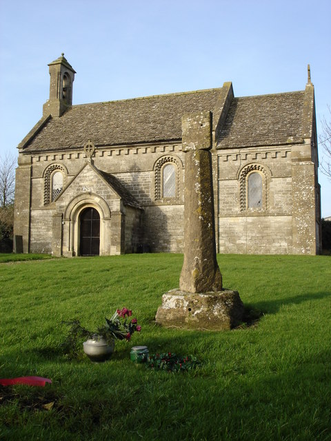
The architecture of Ozleworth reflects its rich history, with many buildings dating back to the medieval period. The centerpiece of the village is the 12th-century St. Nicholas Church, a Grade I listed building that showcases impressive Norman and Gothic architectural features. The church is surrounded by a well-preserved churchyard, providing a peaceful spot for contemplation.

Surrounded by lush greenery, Ozleworth offers numerous opportunities for outdoor activities. The village is close to the Ozleworth Park Estate, a privately-owned estate that boasts extensive woodland, gardens, and a stunning lake, perfect for leisurely walks and picnics. The estate is also home to Ozleworth Mansion, a Grade II listed building that adds to the village's charm.

Despite its small size, Ozleworth has a close-knit community and a warm, welcoming atmosphere. The village has a vibrant social scene, with various community events and activities taking place throughout the year. Additionally, the nearby towns of Wotton-under-Edge and Tetbury offer a range of amenities, including shops, restaurants, and schools.

Overall, Ozleworth is a hidden gem in Gloucestershire, offering a tranquil retreat for those seeking a peaceful countryside experience. Its idyllic setting, historic charm, and strong sense of community make it a truly special place to visit or call home.

If you have any feedback on the listing, please let us know in the comments section below.

Ozleworth Images

Images are sourced within 2km of 51.639789/-2.301107 or Grid Reference ST7993. Thanks to Geograph Open Source API. All images are credited.

Square Pear A sculpture by Richard Cresswell in the garden at Newark House, an exhibit in 'Sculpture in the Garden 2021'
Square Pear
A sculpture by Richard Cresswell in the garden at Newark House, an exhibit in 'Sculpture in the Garden 2021'
Cyclamen and fallen leaves In the grounds of Newark House
Cyclamen and fallen leaves
In the grounds of Newark House
Newark House A grade II listed building built as a hunting lodge by Sir Nicholas Poyntz in the mid 1500s and extended and remodelled several times over the next 400 years. It was given to National Trust in 1949.
Newark House
A grade II listed building built as a hunting lodge by Sir Nicholas Poyntz in the mid 1500s and extended and remodelled several times over the next 400 years. It was given to National Trust in 1949.
Stone Stile, Ozleworth Park To the left of the main gates to the Old Rectory, on Gloucestershire footpath NOZ2 (listed as a Bridleway). Off Blacksmiths Hill.
Stone Stile, Ozleworth Park
To the left of the main gates to the Old Rectory, on Gloucestershire footpath NOZ2 (listed as a Bridleway). Off Blacksmiths Hill.
Crinkle-crankle wall at Newark Park A description is contained in the collection <a title="https://www.geograph.org.uk/gallery/crinkle_crankle_or_serpentine_walls_15374" href="https://www.geograph.org.uk/gallery/crinkle_crankle_or_serpentine_walls_15374">Link</a>
Crinkle-crankle wall at Newark Park
A description is contained in the collection Link
Crinkle-crankle wall at Newark Park A collection featuring these walls <a title="https://www.geograph.org.uk/gallery/crinkle_crankle_or_serpentine_walls_15374" href="https://www.geograph.org.uk/gallery/crinkle_crankle_or_serpentine_walls_15374">Link</a>
Crinkle-crankle wall at Newark Park
A collection featuring these walls Link
In Ozleworth Bottom This is looking past a benchmark <a href="https://www.geograph.org.uk/photo/6935226">ST8092 : Benchmark in Ozleworth Bottom</a> on the right hand of two posts at the eastern end of Ozleworth Bottom to a flat area (extending into the next square east) that looks as if it was an area of water at some time in the recent past. Unlike a more obvious benchmark close-by <a href="https://www.geograph.org.uk/photo/6603653">ST8092 : Benchmark by a track</a>, this one has recently been made more accessible by the absence of trees cut down because of ash dieback.
In Ozleworth Bottom
This is looking past a benchmark ST8092 : Benchmark in Ozleworth Bottom on the right hand of two posts at the eastern end of Ozleworth Bottom to a flat area (extending into the next square east) that looks as if it was an area of water at some time in the recent past. Unlike a more obvious benchmark close-by ST8092 : Benchmark by a track, this one has recently been made more accessible by the absence of trees cut down because of ash dieback.
Benchmark in Ozleworth Bottom This benchmark (OS description: STO P E SIDE TK S SIDE FOOTPATH) needed a bit of gardening to reveal it, even though a number of trees near it had been removed <a href="https://www.geograph.org.uk/photo/6935219">ST8192 : In Ozleworth Bottom</a>.
Benchmark in Ozleworth Bottom
This benchmark (OS description: STO P E SIDE TK S SIDE FOOTPATH) needed a bit of gardening to reveal it, even though a number of trees near it had been removed ST8192 : In Ozleworth Bottom.
Unmapped pond near Ozleworth Bottom There isn't always water in this pond: this image, taken In September, can be compared with December <a href="https://www.geograph.org.uk/photo/300553">ST8193 : Lake in Ozleworth Bottom</a>.
Unmapped pond near Ozleworth Bottom
There isn't always water in this pond: this image, taken In September, can be compared with December ST8193 : Lake in Ozleworth Bottom.
Stone Stile, Bagpath Off a dead-end road connecting with Scrubbett's Lane. Opposite Brook House, on Gloucestershire footpath NKS30, looking SE to a field.
Stone Stile, Bagpath
Off a dead-end road connecting with Scrubbett's Lane. Opposite Brook House, on Gloucestershire footpath NKS30, looking SE to a field.
Stone Stile, Bagpath On Gloucestershire footpaths NKS26 & NKS27, 65 metres SE from Ashcroft Rd, at its nearest point.
Stone Stile, Bagpath
On Gloucestershire footpaths NKS26 & NKS27, 65 metres SE from Ashcroft Rd, at its nearest point.
Ozleworth (Glos) St Nicholas of Myra's Church Difficult to find but a delightful walk to this church vested in the Churches Conservation Trust
Ozleworth (Glos) St Nicholas of Myra's Church
Difficult to find but a delightful walk to this church vested in the Churches Conservation Trust
St Nicholas of Myra, Ozleworth
Newark Park Originally a 16th century hunting lodge but remodelled in the 18th century. in the care of the National Trust
Newark Park
Originally a 16th century hunting lodge but remodelled in the 18th century. in the care of the National Trust
Tyley Bottom, nr Wotton-under-Edge Looking west across one of the many deep coombes that cut far into this part of the Cotswold scarp, to Golden Knoll Wood.
Tyley Bottom, nr Wotton-under-Edge
Looking west across one of the many deep coombes that cut far into this part of the Cotswold scarp, to Golden Knoll Wood.
Muscovy Bottom, Newark Park One of numerous side valleys on the north-west side of Ozleworth Bottom, Taken looking north-east across to Clays Wood from a woodland track on the Newark Park Estate.
Muscovy Bottom, Newark Park
One of numerous side valleys on the north-west side of Ozleworth Bottom, Taken looking north-east across to Clays Wood from a woodland track on the Newark Park Estate.
Lines of maize
Lines of maize
Choices To the left lies the lane to Ozleworth Bottom, to the right the lane to Newark Park.  In the middle is Goose Green radio station mast.
Choices
To the left lies the lane to Ozleworth Bottom, to the right the lane to Newark Park. In the middle is Goose Green radio station mast.
Show me another place!

Ozleworth is located at Grid Ref: ST7993 (Lat: 51.639789, Lng: -2.301107)

Administrative County: Gloucestershire

District: Cotswold

Police Authority: Gloucestershire

What 3 Words

///reputable.natively.eager. Near Wotton-under-Edge, Gloucestershire

Related Wikis

Ozleworth

Ozleworth is a village and civil parish in Gloucestershire, England, approximately 30 km (19 mi) south of Gloucester. It lies in the Cotswolds, an Area...

St Nicholas of Myra's Church, Ozleworth

St Nicholas of Myra's Church is a redundant Anglican church in the village of Ozleworth, Gloucestershire, England, in the care of The Churches Conservation...

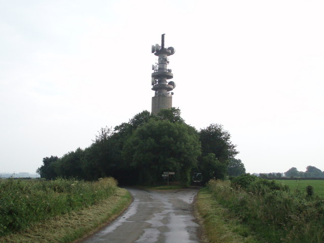
Wotton-under-Edge BT Tower

Wotton-under-Edge Tower is a 76.2 metres ( 250 ft) tall telecommunication tower built of reinforced concrete at Wotton-under-Edge in Gloucestershire, UK...
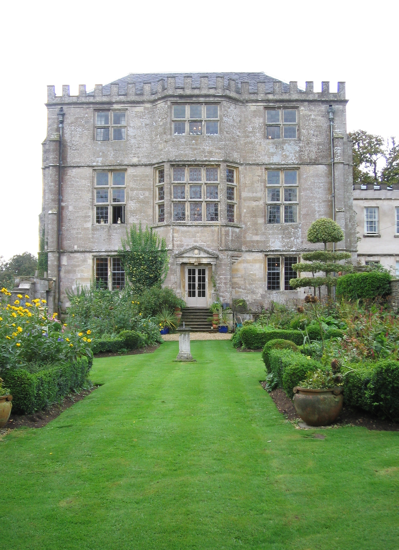
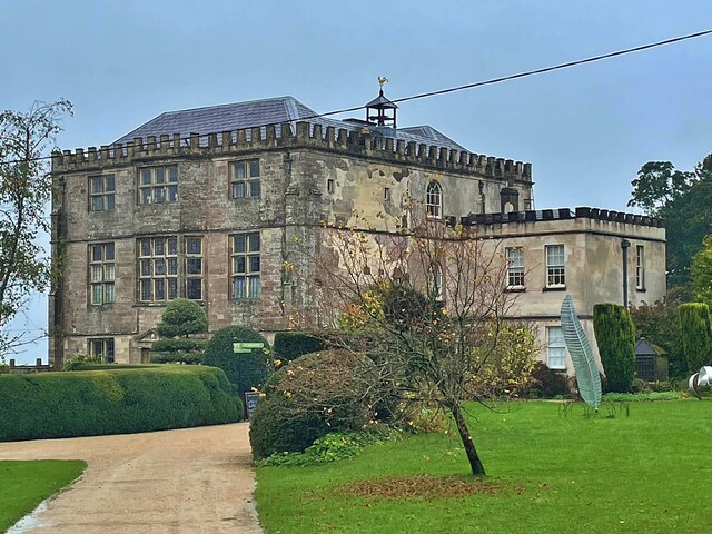
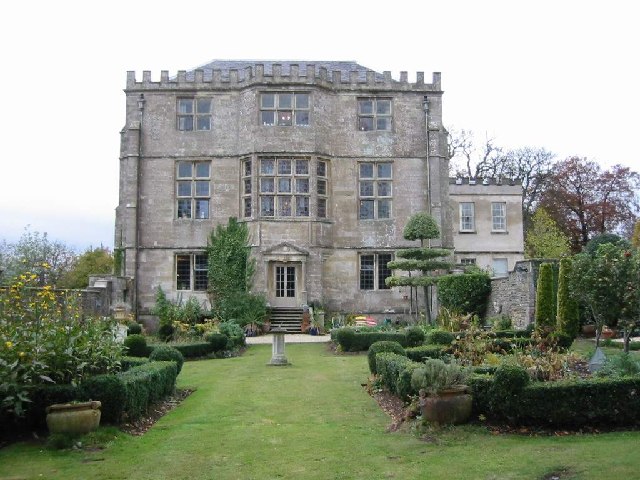
Newark Park

Newark Park is a Grade I listed country house of Tudor origins located near the village of Ozleworth, Wotton-under-Edge, Gloucestershire. The house sits...

Boxwell Court

Boxwell Court is a country house near Leighterton in Gloucestershire, England, about 5 km or 3 miles east of Wotton-under-Edge, dating from the 15th and...

Tresham

Tresham is a village in Gloucestershire, England. It was transferred back from the county of Avon in 1991, having been in Gloucestershire before 1972....

Bagpath

Bagpath is a hamlet in Gloucestershire, England, in the Ozleworth valley south of the village of Kingscote and forming part of Kingscote civil parish....

Boxwell SSSI

Boxwell SSSI (grid reference ST816928) is a 5.31-hectare (13.1-acre) biological Site of Special Scientific Interest in Gloucestershire, notified in 1954...

Nearby Amenities

Located within 500m of 51.639789,-2.301107
Ozleworth
Is In: Gloucestershire, England, UK
Place: village
Postal Code: GL12
Lat/Long: 51.6372779/-2.2979871
Post Box
Collection Times: Mo-Sa 10:30
Operator: Royal Mail
Post Box Type: lamp
Ref: GL12 119
Royal Cypher: EIIR
Royal Cypher Wikidata: Q33102113
Lat/Long: 51.6418564/-2.3029576
Telephone
Booth: K6
Covered: booth
Operator: BT
Payment Coins: no
Payment Notes: no
Payment Telephone Cards: yes
Lat/Long: 51.6418375/-2.3029257
Barrier: cattle_grid
Horse: no
Lat/Long: 51.6408188/-2.2953126
Barrier: stile
Bicycle: yes
Foot: yes
Stile: stepover
Lat/Long: 51.6407916/-2.2999195
Barrier: cattle_grid
Bicycle: yes
Foot: yes
Lat/Long: 51.6380785/-2.3003062
Fixme: line possibly incomplete - where does it go next? survey needed
Power: pole
Transformer: distribution
Lat/Long: 51.6389068/-2.2990166
Power: pole
Lat/Long: 51.6398112/-2.2987043
Power: pole
Lat/Long: 51.6438624/-2.3022269
Power: pole
Lat/Long: 51.6431444/-2.3016933
Power: pole
Lat/Long: 51.6424199/-2.3011574
Power: pole
Lat/Long: 51.6416475/-2.3005655
Power: pole
Lat/Long: 51.6403673/-2.2993793
Power: pole
Lat/Long: 51.6409172/-2.3000261
Power: pole
Lat/Long: 51.6408737/-2.3010729
Power: pole
Lat/Long: 51.6407847/-2.3024063
Power: pole
Lat/Long: 51.6406993/-2.3041637
Power: pole
Lat/Long: 51.6406294/-2.305533
Power: pole
Lat/Long: 51.6405703/-2.3066796
Power: pole
Lat/Long: 51.6404821/-2.3078182
Barrier: kissing_gate
Lat/Long: 51.6408688/-2.298588
Ford: yes
Lat/Long: 51.6427569/-2.2969693
Barrier: kissing_gate
Lat/Long: 51.6427685/-2.2969387
Parking
Access: yes
Fee: no
Parking: street_side
Lat/Long: 51.6401407/-2.3009817
Bench
Backrest: yes
Lat/Long: 51.6418375/-2.3029462
The data included in this document is from www.openstreetmap.org. The data is made available under ODbL.

Have you been to Ozleworth?

Leave your review of Ozleworth below (or comments, questions and feedback).