Gate, Old

Settlement in Lincolnshire South Holland

England

Gate, Old

Main Drain Bridge This bridge carries the road over the South Holland Main Drain.
Main Drain Bridge Credit: Michael Patterson

Gate, Old is a small village located in the county of Lincolnshire, England. Situated approximately 10 miles north of the town of Boston, it forms part of the East Lindsey district. With a population of around 200 residents, Gate, Old is known for its rural charm and picturesque surroundings.

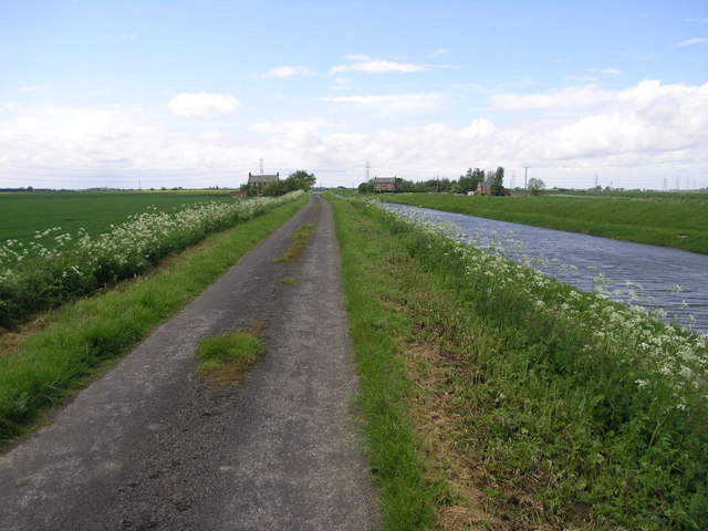
The village is nestled in the heart of the Lincolnshire Fens, an area renowned for its flat, fertile agricultural land. The landscape is dominated by extensive fields, providing a tranquil and scenic setting. Gate, Old benefits from its close proximity to the River Witham, which flows nearby, offering opportunities for leisurely walks and fishing activities.

The village features a range of traditional architectural styles, including charming cottages and farmhouses, which add to its character and appeal. The local community is tight-knit and friendly, with residents often participating in various social events and activities organized throughout the year.

Despite its small size, Gate, Old boasts a few amenities to cater to the needs of its residents. These include a village hall, a primary school, and a local pub, serving as a hub for social gatherings and community meetings. The village is well-connected to neighboring areas by a network of roads, making it easily accessible.

Overall, Gate, Old offers a peaceful and idyllic lifestyle, making it an attractive place to reside for those seeking a rural retreat with close-knit community values.

If you have any feedback on the listing, please let us know in the comments section below.

Gate, Old Images

Images are sourced within 2km of 52.7674/0.1017 or Grid Reference TF4120. Thanks to Geograph Open Source API. All images are credited.

Main Drain Bridge This bridge carries the road over the South Holland Main Drain.
Main Drain Bridge
This bridge carries the road over the South Holland Main Drain.
Farm and Lane and Drain Woad Farm (Woad Mill Farm,1940s OS) sits on the raised banks of South Holland Main Drain.
Farm and Lane and Drain
Woad Farm (Woad Mill Farm,1940s OS) sits on the raised banks of South Holland Main Drain.
Dutch Barn This Dutch Barn with its curved roof is an increasingly rare sight as they are replaced by more modern styles of agricultural building.
Dutch Barn
This Dutch Barn with its curved roof is an increasingly rare sight as they are replaced by more modern styles of agricultural building.
Field and a Farm The field is near the north edge of this square.  The farm (Onslow) is in the next square north.
Field and a Farm
The field is near the north edge of this square. The farm (Onslow) is in the next square north.
Stripy Field This field has had a stripe cultivated into it.  I assume the farmer was around the other side of the field completing the next stripe.
Stripy Field
This field has had a stripe cultivated into it. I assume the farmer was around the other side of the field completing the next stripe.
Footpath to Sutton This footpath crosses the busy A17, just over this field, on its way to Long Sutton.  The two ducks in the field looked a little lost.
Footpath to Sutton
This footpath crosses the busy A17, just over this field, on its way to Long Sutton. The two ducks in the field looked a little lost.
The South Holland Main Drain near Sutton St James. A Sunday fishing match, one of the last of the season, had just finished on this wide and windswept main drain in south Lincolnshire.
The South Holland Main Drain near Sutton St James.
A Sunday fishing match, one of the last of the season, had just finished on this wide and windswept main drain in south Lincolnshire.
Foreman's Bridge over the South Holland Main Drain. Sitting right on the OS grid boundary, Foreman's Bridge looks almost medieval with its warm and mellow brick, but probably dates from the 1860s.
Foreman's Bridge over the South Holland Main Drain.
Sitting right on the OS grid boundary, Foreman's Bridge looks almost medieval with its warm and mellow brick, but probably dates from the 1860s.
Gowts Lane, Lincolnshire This track runs down to the South Holland Main Drain in <a href="https://www.geograph.org.uk/gridref/TF4219">TF4219</a>.
Gowts Lane, Lincolnshire
This track runs down to the South Holland Main Drain in TF4219.
Road junction north of Sutton St James Probably an old drove road upgraded and metalled in the early 20th century, this road junction lies between Long Sutton and Sutton St James.
Road junction north of Sutton St James
Probably an old drove road upgraded and metalled in the early 20th century, this road junction lies between Long Sutton and Sutton St James.
Cowper's Gate near Delph Field's
Pulvertoft Hall, Gedney Broadgate The large Georgian farmhouse for Pulvertoft Hall Farm on the junction of Cade Lane with Harford Gate.
Pulvertoft Hall, Gedney Broadgate
The large Georgian farmhouse for Pulvertoft Hall Farm on the junction of Cade Lane with Harford Gate.
Fleet River, Gedney Fen Called a river but really a drain. Looking towards Garnsgate.
Fleet River, Gedney Fen
Called a river but really a drain. Looking towards Garnsgate.
Garnsgate Lutton Garnsgate and Lutton Drain. The Garnsgate houses are all on the left hand side of the road behind the trees.
Garnsgate
Lutton Garnsgate and Lutton Drain. The Garnsgate houses are all on the left hand side of the road behind the trees.
Garnsgate Road The road makes a sweeping double bend as it enters Garnsgate. These houses and farm buildings are the first as you come to in this linear village built on the west side of the road.
Garnsgate Road
The road makes a sweeping double bend as it enters Garnsgate. These houses and farm buildings are the first as you come to in this linear village built on the west side of the road.
Gedney Broadgate Looking NNE along Harford Gate from Cade Drove. Nearly all the houses in this village are behind tall, wind-breaking hedges on the west side of the road.
Gedney Broadgate
Looking NNE along Harford Gate from Cade Drove. Nearly all the houses in this village are behind tall, wind-breaking hedges on the west side of the road.
Fenland landscape Flat, seemingly endless fields are typical of the Lincolnshire Fens. Here Cade Drove meets Hunt's Gate at Homeleigh Farm.
Fenland landscape
Flat, seemingly endless fields are typical of the Lincolnshire Fens. Here Cade Drove meets Hunt's Gate at Homeleigh Farm.
Hunt's Gate Looking north from the Cade Drove junction.
Hunt's Gate
Looking north from the Cade Drove junction.
Show me another place!

Gate, Old is located at Grid Ref: TF4120 (Lat: 52.7674, Lng: 0.1017)

Division: Parts of Holland

Administrative County: Lincolnshire

District: South Holland

Police Authority: Lincolnshire

What 3 Words

///silly.export.palettes. Near Fleet, Lincolnshire

Nearby Locations

Gate, Old Old Gate

Related Wikis

Low Fulney

Low Fulney is a hamlet in the South Holland district of Lincolnshire, England. It is in the Spalding St. Paul's ward of the South Holland District Council...

Gedney Broadgate

Gedney Broadgate is a hamlet in the civil parish of Gedney and the South Holland district of Lincolnshire, England. It is situated west from the A17 road...

Long Sutton railway station

Long Sutton railway station was a station in Long Sutton, Lincolnshire, England. It was part of the Midland and Great Northern Joint Railway which closed...

Long Sutton, Lincolnshire

Long Sutton is a market town in the South Holland district of Lincolnshire, England. It lies in The Fens, close to the Wash, 13 miles (21 km) east of Spalding...

Nearby Amenities

Located within 500m of 52.7674,0.1017
Burliesgate Farm
Historic Place: farm
Source: Bing
Lat/Long: 52.7681603/0.0999443
Onslow Farm
Place: farm
Source: Bing
Lat/Long: 52.7685754/0.1088476
Spendla's Farm
Place: farm
Source: Bing
Lat/Long: 52.7667771/0.1010305
Power: pole
Lat/Long: 52.7682663/0.0949801
Power: pole
Lat/Long: 52.7686089/0.0965746
Power: pole
Lat/Long: 52.7689858/0.0981516
Power: pole
Lat/Long: 52.7693153/0.0997331
Power: pole
Lat/Long: 52.769472/0.1009453
Power: pole
Lat/Long: 52.7697532/0.102655
Power: pole
Lat/Long: 52.7699853/0.1042198
Power: pole
Lat/Long: 52.7701375/0.1056013
The data included in this document is from www.openstreetmap.org. The data is made available under ODbL.

Have you been to Gate, Old?

Leave your review of Gate, Old below (or comments, questions and feedback).