Northpunds

Settlement in Shetland

Scotland

Northpunds

Lay-by beside the A970 road Near Levenwick.
Lay-by beside the A970 road Credit: John Lucas

Northpunds is a small village located in the Shetland Islands, which are in the northernmost part of Scotland. Situated on the eastern coast of the main island, it is surrounded by picturesque landscapes and breathtaking views of the North Sea. The village is known for its tranquil atmosphere and close-knit community.

With a population of around 200 residents, Northpunds offers a peaceful retreat for those seeking a slower pace of life. Traditional Shetland houses, known as crofts, dot the landscape, adding to the village's charming character. The local economy primarily revolves around fishing and agriculture, as well as tourism.

Nature enthusiasts will find plenty to explore in and around Northpunds. The coastline is rugged and dramatic, with towering cliffs and pristine beaches. The area is a haven for birdwatchers, as a variety of seabirds nest along the cliffs, including puffins, guillemots, and kittiwakes. Additionally, seals and otters can often be spotted in the surrounding waters.

Northpunds boasts a strong sense of community, with various events and activities throughout the year. The village hall serves as a gathering place for social events, such as ceilidhs and community meetings. The local school plays a vital role in the community, providing education for the village's children.

Visitors to Northpunds can enjoy the tranquility of the village, explore the stunning natural surroundings, and experience the warm hospitality of the locals. Whether it's a peaceful walk along the coast or a friendly chat with a neighbor, Northpunds offers a true taste of Shetland life.

If you have any feedback on the listing, please let us know in the comments section below.
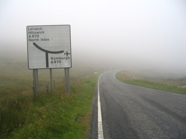
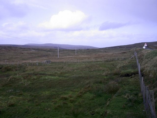
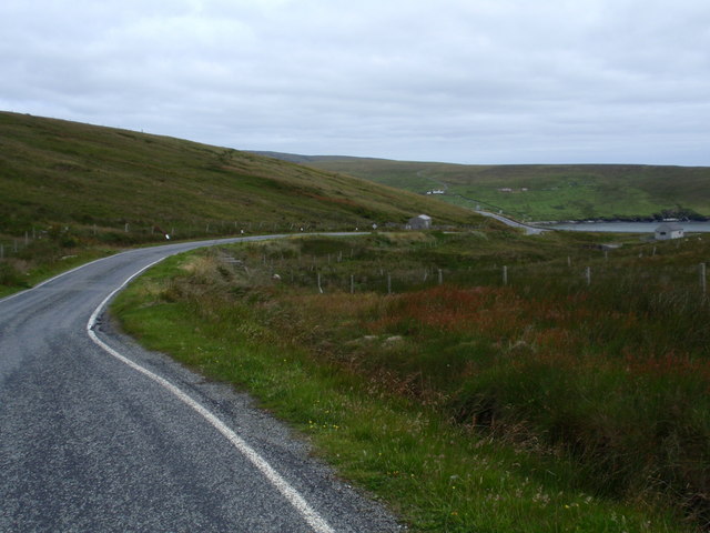
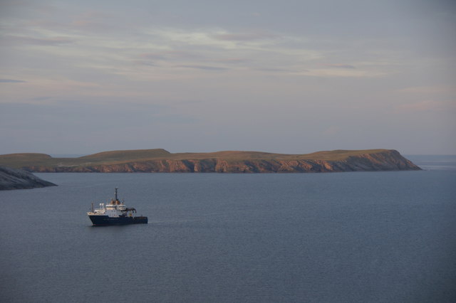
Northpunds Images

Images are sourced within 2km of 59.982106/-1.2725897 or Grid Reference HU4022. Thanks to Geograph Open Source API. All images are credited.

Lay-by beside the A970 road Near Levenwick.
Lay-by beside the A970 road
Near Levenwick.
Levenwick from the air
Quinni Geo, Levenwick, from the air
Sneu of Ellister A nice round hill on the way to Bigton.
One of the great things about a visit to Shetland is all the new words you come across.
I guess Sneu means Hill or similar, but just to check I googled it.
Not much luck I'm afraid, but for today's trivia I can tell you that Sneu is Dutch for Pathetic and also an acronym for Street Narcotics Enforcement Unit.
Sneu of Ellister
A nice round hill on the way to Bigton. One of the great things about a visit to Shetland is all the new words you come across. I guess Sneu means Hill or similar, but just to check I googled it. Not much luck I'm afraid, but for today's trivia I can tell you that Sneu is Dutch for Pathetic and also an acronym for Street Narcotics Enforcement Unit.
B9122, a Single Track Road with Passing Places The B9122 is a narrow, mostly single-track road with passing places. It provides a pleasant diversion from the A970 near Channerwick, travelling to the western (Atlantic) coast at Bigton and then Scousburgh before turning east again to rejoin the A970 at Boddam.
B9122, a Single Track Road with Passing Places
The B9122 is a narrow, mostly single-track road with passing places. It provides a pleasant diversion from the A970 near Channerwick, travelling to the western (Atlantic) coast at Bigton and then Scousburgh before turning east again to rejoin the A970 at Boddam.
B9122 near to Northpunds Volkswagen minibus (RE10 SBO) operating on the Bigton and Quendale Feeder Route (Service 7).
B9122 near to Northpunds
Volkswagen minibus (RE10 SBO) operating on the Bigton and Quendale Feeder Route (Service 7).
Blind Summit on the B9122 The B9122 is a narrow, mostly single-track road with passing places. It provides a pleasant diversion from the A970 near Channerwick, travelling to the western (Atlantic) coast at Bigton and then Scousburgh before turning east again to rejoin the A970 at Boddam.
Blind Summit on the B9122
The B9122 is a narrow, mostly single-track road with passing places. It provides a pleasant diversion from the A970 near Channerwick, travelling to the western (Atlantic) coast at Bigton and then Scousburgh before turning east again to rejoin the A970 at Boddam.
Passing Place on the B9122 The B9122 is a narrow, mostly single-track road with passing places. It provides a pleasant diversion from the A970 near Channerwick, travelling to the western (Atlantic) coast at Bigton and then Scousburgh before turning east again to rejoin the A970 at Boddam.
Passing Place on the B9122
The B9122 is a narrow, mostly single-track road with passing places. It provides a pleasant diversion from the A970 near Channerwick, travelling to the western (Atlantic) coast at Bigton and then Scousburgh before turning east again to rejoin the A970 at Boddam.
Road sign at junction of B9122 and A970 OK, so you can't see the junction itself - but neither could I in that weather! Apart from a small puddle, there doesn't seem to be anything else of note in this square.
Road sign at junction of B9122 and A970
OK, so you can't see the junction itself - but neither could I in that weather! Apart from a small puddle, there doesn't seem to be anything else of note in this square.
Parallel communications The square is peaty moorland: here the B9122 and electricity poles run parallel to the Red Burn
Parallel communications
The square is peaty moorland: here the B9122 and electricity poles run parallel to the Red Burn
Road B9122 view northeast to Channerwick
Red burn of Williamsetter View west to St Ninians isle
Red burn of Williamsetter
View west to St Ninians isle
Blind summit... On the Bigton road - just amused me... (it was brilliant sunshine 5 miles north!)
Blind summit...
On the Bigton road - just amused me... (it was brilliant sunshine 5 miles north!)
NLV Pole Star anchored off Levenwick One of the Northern Lighthouse Board's lighthouse service vessels. Cumlewick Ness is just visible on the left, with No Ness in the background.
NLV Pole Star anchored off Levenwick
One of the Northern Lighthouse Board's lighthouse service vessels. Cumlewick Ness is just visible on the left, with No Ness in the background.
Channer Wick View from the road in to Channer Wick
Channer Wick
View from the road in to Channer Wick
At the Ness of Hoswick Evening was fast approaching and the sky taking on a brownish hue.
At the Ness of Hoswick
Evening was fast approaching and the sky taking on a brownish hue.
The Berg, Ness of Hoswick The Point between Hos Wick and Channer Wick.
The Berg, Ness of Hoswick
The Point between Hos Wick and Channer Wick.
Show me another place!

Northpunds is located at Grid Ref: HU4022 (Lat: 59.982106, Lng: -1.2725897)

Unitary Authority: Shetland Islands

Police Authority: Highlands and Islands

What 3 Words

///tolerates.steepest.fakes. Near Sandwick, Shetland Islands

Related Wikis

Levenwick

Levenwick is a small village about 17 miles (27 km) south of Lerwick, on the east side of the South Mainland of Shetland, Scotland. It is part of the parish...

Hoswick

Hoswick is a settlement in Sandwick in the south mainland of Shetland, Scotland, on the eastern part of the Dunrossness civil parish. It is separated from...

Bigton

Bigton is a small settlement on South Mainland, Shetland, UK. Bigton is within the civil parish of Dunrossness.Bigton lies on the Atlantic coast of the...

Sandwick, Dunrossness

see also Sandwick, Whalsay and Sandwick, OrkneySandwick (Old Norse: Sandvik "Sandy Bay") is a village and an ancient parish in the Shetland Islands, Scotland...

Clumlie Broch

Clumlie Broch is an Iron Age broch located on Mainland, Shetland, in Scotland (grid reference HU40451811). == Location == Clumlie Broch is located in Dunrossness...

St Ninian's Isle

St Ninian's Isle is a small tied island connected by the largest tombolo in the UK to the south-western coast of the Mainland, Shetland, in Scotland. It...

Scousburgh

Scousburgh is a small community in the parish of Dunrossness, in the South Mainland of Shetland, Scotland, overlooking the picturesque Scousburgh Sand...

Dunrossness

Dunrossness, (Old Norse: Dynrastarnes meaning "headland of the loud tide-race", referring to the noise of Sumburgh Roost) is the southernmost parish of...

Nearby Amenities

Located within 500m of 59.982106,-1.2725897
Northpunds
Place: hamlet
Lat/Long: 59.9819227/-1.2719467
Power: pole
Lat/Long: 59.9864306/-1.2724936
Power: pole
Lat/Long: 59.9860214/-1.2722468
Power: pole
Lat/Long: 59.9849172/-1.2715146
Power: pole
Lat/Long: 59.9849467/-1.2718043
Power: pole
Lat/Long: 59.9859288/-1.2724426
Power: pole
Lat/Long: 59.9862562/-1.2726358
Power: pole
Lat/Long: 59.9844597/-1.2715253
Power: pole
Lat/Long: 59.984029/-1.2715736
Power: pole
Lat/Long: 59.983456/-1.2716246
Power: pole
Lat/Long: 59.9827342/-1.271705
Power: pole
Lat/Long: 59.9820928/-1.2721596
Power: pole
Lat/Long: 59.9814715/-1.272617
Power: pole
Lat/Long: 59.9808193/-1.2730944
Power: pole
Lat/Long: 59.9799471/-1.2737328
Power: pole
Lat/Long: 59.9792506/-1.2742317
Power: pole
Lat/Long: 59.97873/-1.2746233
Power: pole
Lat/Long: 59.9781167/-1.2747708
Power: pole
Lat/Long: 59.9778309/-1.2710521
Power: pole
Lat/Long: 59.9783256/-1.2710798
Power: pole
Lat/Long: 59.9790363/-1.2711445
Power: pole
Lat/Long: 59.9798627/-1.2712092
Power: pole
Lat/Long: 59.9800753/-1.2712253
Power: pole
Lat/Long: 59.9805145/-1.2712577
Power: pole
Lat/Long: 59.981068/-1.2713039
Power: pole
Lat/Long: 59.9817556/-1.2713709
Power: pole
Lat/Long: 59.9823797/-1.2714171
Power: pole
Lat/Long: 59.9829783/-1.2713778
Power: pole
Lat/Long: 59.9835641/-1.2713316
Power: pole
Lat/Long: 59.984202/-1.2712808
Power: pole
Lat/Long: 59.9800615/-1.2721909
Power: pole
Lat/Long: 59.980036/-1.2734406
Bus Stop
Levenwick Junction
Bus: yes
Fixme: Location unknown
Public Transport: platform
Lat/Long: 59.9823195/-1.2727202
Bus Stop
Levenwick Junction
Bus: yes
Fixme: Location unknown
Public Transport: platform
Lat/Long: 59.9823397/-1.2725285
The data included in this document is from www.openstreetmap.org. The data is made available under ODbL.

Have you been to Northpunds?

Leave your review of Northpunds below (or comments, questions and feedback).