North Tarrel

Settlement in Cromartyshire

Scotland

North Tarrel

Coastal path at Creagan Dubha
Coastal path at Creagan Dubha Credit: sylvia duckworth

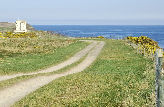
North Tarrel is a small village located in the county of Cromartyshire, in the northern part of Scotland. Situated on the eastern coast of the Black Isle peninsula, it lies about 12 miles northeast of the county town of Cromarty.

The village is characterized by its picturesque setting, surrounded by rolling hills and offering stunning views of the North Sea. Its population is around 500 residents, giving it a tight-knit community feel. The village is predominantly residential, with a few small businesses catering to the local population.

North Tarrel is known for its peaceful and idyllic atmosphere, making it a popular destination for those seeking a tranquil retreat. The village is dotted with charming cottages, many of which have been beautifully preserved, showcasing traditional Scottish architecture.

The area surrounding North Tarrel offers a range of outdoor activities for nature enthusiasts. The nearby Black Isle Wildlife Park is a popular attraction, providing opportunities to observe a variety of native and exotic animal species. Additionally, the coastal location of the village allows residents and visitors to enjoy scenic walks along the cliffs or relax on the sandy beaches.

While North Tarrel does not have its own school or major amenities, it benefits from its proximity to larger towns, such as Cromarty, where residents can access a wider range of services and facilities. Overall, North Tarrel provides a serene and picturesque living environment for its residents, attracting visitors who appreciate its natural beauty and tranquility.

If you have any feedback on the listing, please let us know in the comments section below.

North Tarrel Images

Images are sourced within 2km of 57.811234/-3.8582874 or Grid Reference NH8981. Thanks to Geograph Open Source API. All images are credited.

Coastal path at Creagan Dubha
Rough sea at Creagan Dubha Rocks below the cliffs at Geanies.
Rough sea at Creagan Dubha
Rocks below the cliffs at Geanies.
Foreshore at Geanies The shore here is mostly covered with a cobble beach. The south shore of the Moray Firth is faintly visible on the horizon.
Foreshore at Geanies
The shore here is mostly covered with a cobble beach. The south shore of the Moray Firth is faintly visible on the horizon.
A Small Bay at Geanies This view is typical of this stretch of the shore - sharp, angular rocks offshore, and a beach of coarse cobbles.
A Small Bay at Geanies
This view is typical of this stretch of the shore - sharp, angular rocks offshore, and a beach of coarse cobbles.
Track to the Shore The track from Mains of Geanies leads down here to join the track along the beach.
Track to the Shore
The track from Mains of Geanies leads down here to join the track along the beach.
Gate to the shore track, Geanies
The old mill stream at Geanies The old mill was sited here, using the head of water descending the raised beach.
The old mill stream at Geanies
The old mill was sited here, using the head of water descending the raised beach.
Beach stones, Geanies
Rocky shore near Geanies
Sunrise from Meikle Tarrel The sunrise viewed from the edge of a plantation of conifers at Meikle Tarrel.
Sunrise from Meikle Tarrel
The sunrise viewed from the edge of a plantation of conifers at Meikle Tarrel.
Approaching Rockfield Mills
Old milestone Since the last photo of this milestone was submitted <a href="https://www.geograph.org.uk/photo/6096205">NH9082 : Old Milestone by the B9165, Wester Seafield, Portmahomack</a> a new fence has been erected by The Pines in Wester Seafield on the B9165.  Also, the painted legend has disappeared.   The circumference of the stone is 95cm. 1880 6" OS Balnagown Bridge 11 Tarbetness 4, 1907 Portmahomack 1 Fearn Station 7½
Old milestone
Since the last photo of this milestone was submitted NH9082 : Old Milestone by the B9165, Wester Seafield, Portmahomack a new fence has been erected by The Pines in Wester Seafield on the B9165. Also, the painted legend has disappeared. The circumference of the stone is 95cm. 1880 6" OS Balnagown Bridge 11 Tarbetness 4, 1907 Portmahomack 1 Fearn Station 7½
Beach between Portmahomack and Inver
Road bend near Tarrel Road is the B9165.  Houses in distance on right are Loch Dhu.
Road bend near Tarrel
Road is the B9165. Houses in distance on right are Loch Dhu.
Fields and wind turbine near Tarrel Fields had been used for growing potatoes which were being harvested at the time this was taken.
Fields and wind turbine near Tarrel
Fields had been used for growing potatoes which were being harvested at the time this was taken.
Junction at Geanies
Junction at Geanies
Left to Port, right to Fearn
Esker, Balnaha A stripwood contains a fine example of an esker.
Esker, Balnaha
A stripwood contains a fine example of an esker.
Show me another place!

North Tarrel is located at Grid Ref: NH8981 (Lat: 57.811234, Lng: -3.8582874)

Unitary Authority: Highland

Police Authority: Highlands and Islands

What 3 Words

///jiffy.gazes.drive. Near Balintore, Highland

Nearby Locations

Tarrel North Tarrel

Related Wikis

Toulvaddie

Toulvaddie (Scottish Gaelic: Toll a' Mhadaidh) is a hamlet, in the Tarbat peninsula, located in Tain, Ross-shire, Scottish Highlands and is in the Scottish...

Ballone Castle

Ballone Castle was built in the 16th century. It was unoccupied for a couple of centuries and fell into ruin. In the 1990s it was purchased and restored...

Rockfield, Highland

Rockfield (Scottish Gaelic: Creag Tarail Bhig) is a hamlet in the parish of Tarbat, on the Tarbat Peninsula, near the village of Portmahomack, Easter...

Arboll

Arboll (Scottish Gaelic: Àrbol) is a place in the parish of Tarbat, Easter Ross, Highland, northern Scotland made up of several scattered farms. It is...

Christian Focus Publications

Christian Focus Publications (CFP) is a conservative, evangelical publishing house in the United Kingdom.CFP was established in the early 1970s, and is...

Tarbat

Tarbat (Gaelic tairbeart, meaning 'a crossing or isthmus') is a civil parish in Highland, Scotland, in the north-east corner of Ross and Cromarty. The...

Portmahomack

Portmahomack (Scottish Gaelic: Port Mo Chalmaig; 'Haven of My [i.e. 'Saint'] Colmóc') is a small fishing village in Easter Ross, Scotland. It is situated...

Portmahomack sculpture fragments

The Portmahomack sculpture fragments are the slabs and stone fragments which have been discovered at the Easter Ross settlement of Portmahomack (Tarbat...

Nearby Amenities

Located within 500m of 57.811234,-3.8582874
Power: pole
Lat/Long: 57.8081446/-3.8631028
Power: pole
Lat/Long: 57.8089165/-3.8634396
Power: pole
Lat/Long: 57.8094722/-3.8636872
Power: pole
Lat/Long: 57.8100473/-3.8639348
Power: pole
Lat/Long: 57.8105489/-3.8641417
Power: pole
Lat/Long: 57.8109748/-3.8648357
Power: pole
Lat/Long: 57.8111564/-3.8658463
Power: pole
Lat/Long: 57.8110667/-3.8637531
Power: pole
Lat/Long: 57.8113293/-3.8625519
Power: pole
Lat/Long: 57.8115866/-3.8613242
Power: pole
Lat/Long: 57.8118428/-3.8602731
The data included in this document is from www.openstreetmap.org. The data is made available under ODbL.

Have you been to North Tarrel?

Leave your review of North Tarrel below (or comments, questions and feedback).