Betws Ifan

Settlement in Cardiganshire

Wales

Betws Ifan

View due north from Pen-y-Banc At this time Pen-y-Banc was a children's activity centre.
View due north from Pen-y-Banc Credit: John Firth

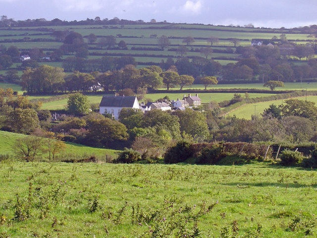
Betws Ifan is a small village located in the county of Cardiganshire, Wales. Situated in the beautiful Teifi Valley, this charming village is surrounded by lush green countryside and rolling hills, offering picturesque views to its residents and visitors.

The village is home to a close-knit community, consisting of approximately 200 residents. The village is known for its peaceful and tranquil atmosphere, making it an ideal place for those seeking a retreat from the busy city life. The community spirit is strong in Betws Ifan, with locals often coming together for various events and activities.

One of the notable landmarks in the village is the St. Ifan's Church, a historic building dating back to the 13th century. Its architecture showcases a blend of medieval and Gothic styles, and it serves as a focal point for the religious and cultural life of the village.

Nature enthusiasts will find Betws Ifan especially appealing, as it is surrounded by stunning natural landscapes. The Teifi River flows nearby, offering opportunities for fishing and boating. The village is also a gateway to the beautiful Ceredigion coast, with its sandy beaches and rugged cliffs.

Despite its small size, Betws Ifan has a strong sense of community and offers a peaceful and idyllic lifestyle for its residents. With its natural beauty and historic charm, this village in Cardiganshire is a hidden gem waiting to be explored.

If you have any feedback on the listing, please let us know in the comments section below.

Betws Ifan Images

Images are sourced within 2km of 52.101968/-4.482264 or Grid Reference SN3047. Thanks to Geograph Open Source API. All images are credited.

View due north from Pen-y-Banc At this time Pen-y-Banc was a children's activity centre.
View due north from Pen-y-Banc
At this time Pen-y-Banc was a children's activity centre.
Pen-y-Banc activity centre Now a private house
Pen-y-Banc activity centre
Now a private house
Betws Ifan church
Betws Ifan church
Road through Betws Ifan
Betws Ifan village hall
Minor road south of Betws Ifan
Narrow lane to Pen-y-banc From crossroads on Betws Ifan road
Narrow lane to Pen-y-banc
From crossroads on Betws Ifan road
Pen-y-banc in 2013 Now a private house. Compare this with view taken in 1993 <a title="https://www.geograph.org.uk/photo/3545911" href="https://www.geograph.org.uk/photo/3545911">Link</a>
Pen-y-banc in 2013
Now a private house. Compare this with view taken in 1993 Link
View across the valley from Pen-y-Banc
Lane west from Pen-y-Banc
The old shop at Betws Ifan
Ordnance Survey Cut Mark This OS cut mark can be found on the end of the north parapet of the bridge. It marks a point 114.722m above mean sea level.
Ordnance Survey Cut Mark
This OS cut mark can be found on the end of the north parapet of the bridge. It marks a point 114.722m above mean sea level.
Ordnance Survey Cut Mark This OS cut mark can be found on Llwyn-celyn. It marks a point 127.031m above mean sea level.
Ordnance Survey Cut Mark
This OS cut mark can be found on Llwyn-celyn. It marks a point 127.031m above mean sea level.
Ordnance Survey Cut Mark This OS cut mark can be found on a boulder behind the gate on the NE side of the road. It marks a point 138.088m above mean sea level.
Ordnance Survey Cut Mark
This OS cut mark can be found on a boulder behind the gate on the NE side of the road. It marks a point 138.088m above mean sea level.
Ordnance Survey Cut Mark This OS cut mark can be found on a disturbed boulder at the hedge junction NE side of the road. It marked a point 452.6ft above mean sea level.
Ordnance Survey Cut Mark
This OS cut mark can be found on a disturbed boulder at the hedge junction NE side of the road. It marked a point 452.6ft above mean sea level.
Gaer Pwntan Parked below house of Preston North End supporter then used good marked footpath to access Pwntan Quarry trig at the summit.
Name: Gaer Pwntan
Hill number: 15361
Height:225m / 738ft
Parent (Ma/M): 2221  Rhos Ymryson
Section:31C: South-West Wales
County/UA: Cardiganshire [Ceredigion] (CoU)
Class: Tump (200-299m)
Grid ref:SN291493 (est)
Drop: 41m
Col:184m  SN313508
Gaer Pwntan
Parked below house of Preston North End supporter then used good marked footpath to access Pwntan Quarry trig at the summit. Name: Gaer Pwntan Hill number: 15361 Height:225m / 738ft Parent (Ma/M): 2221 Rhos Ymryson Section:31C: South-West Wales County/UA: Cardiganshire [Ceredigion] (CoU) Class: Tump (200-299m) Grid ref:SN291493 (est) Drop: 41m Col:184m SN313508
Ordnance Survey Cut Mark This OS cut mark can be found on the gatepost NE side of the road. It marks a point 150.375m above mean sea level.
Ordnance Survey Cut Mark
This OS cut mark can be found on the gatepost NE side of the road. It marks a point 150.375m above mean sea level.
Ordnance Survey Cut Mark This OS cut mark can be found on the wall at the entrance to Plas Troedyraur. It marks a point 135.536m above mean sea level.
Ordnance Survey Cut Mark
This OS cut mark can be found on the wall at the entrance to Plas Troedyraur. It marks a point 135.536m above mean sea level.
Show me another place!

Betws Ifan is located at Grid Ref: SN3047 (Lat: 52.101968, Lng: -4.482264)

Unitary Authority: Ceredigion

Police Authority: Dyfed Powys

What 3 Words

///motoring.munch.waistcoat. Near Aberporth, Ceredigion

Nearby Locations

Betws Ifan

Related Wikis

Betws Ifan

Betws Ifan (antiquarian forms include Bettws Evan and Bettws Ieuvan) is a small village located in Ceredigion, Wales. Surrounding villages include Beulah...

Tŷ-llwyd

Tŷ-llwyd is an old mansion and estate in the community of Beulah, Ceredigion, Wales, which is 71.4 miles (114.8 km) from Cardiff and 191.4 miles (308...

Glynarthen

Glynarthen is a small village located in Ceredigion, Wales. It is part of the community of Penbryn, along with the neighbouring villages of Brynhoffnant...

Beulah, Ceredigion

Beulah (Welsh: Bwla) is a small village, wider community and electoral ward located halfway between the market town of Newcastle Emlyn and the seaside...

Tan-y-groes

Tan-y-groes (or Tanygroes) is a hamlet in the community of Penbryn, Ceredigion, Wales, which is 11 km (7 mi) east of Cardigan on the A487 trunk road....

Beddgeraint

Beddgeraint is a small village in the community of Penbryn, Ceredigion, Wales, which is 69 miles (111.1 km) from Cardiff and 189.1 miles (304.4 km) from...

Felin-Wnda

Felin-Wnda is a hamlet in the community of Troedyraur, Ceredigion, Wales, which is 69 miles (111.1 km) from Cardiff and 189 miles (304.1 km) from London...

Llain-wen

Llain-wen is a hamlet in the community of Penbryn, Ceredigion, Wales, which is 71.9 miles (115.7 km) from Cardiff and 191.9 miles (308.8 km) from London...

Nearby Amenities

Located within 500m of 52.101968,-4.482264
Betws Ifan
Is In: Ceredigion, Wales, UK
Old Name: Bettws-Evan;Bettws Ieuvan
Place: village
Source: npe
Wikidata: Q3402056
Wikipedia: en:Betws Ifan
Lat/Long: 52.0999764/-4.4788226
Board Type: notice
Direction: 240
Information: board
Lat/Long: 52.1018765/-4.4816328
Give Way
Direction: backward
Lat/Long: 52.1047695/-4.4847426
Direction: WSW
Generator Method: photovoltaic
Generator Output Electricity: yes
Generator Solar Modules: 14
Generator Source: solar
Generator Type: solar_photovoltaic_panel
Location: roof
Power: generator
Lat/Long: 52.0999818/-4.4805229
Direction: ENE
Generator Method: photovoltaic
Generator Output Electricity: yes
Generator Solar Modules: 8
Generator Source: solar
Generator Type: solar_photovoltaic_panel
Location: roof
Power: generator
Lat/Long: 52.0999952/-4.4804572
Direction: SSE
Generator Method: photovoltaic
Generator Output Electricity: yes
Generator Solar Modules: 15
Generator Source: solar
Generator Type: solar_photovoltaic_panel
Location: roof
Power: generator
Lat/Long: 52.1035151/-4.4839548
Give Way
Direction: backward
Lat/Long: 52.104875/-4.4847621
The data included in this document is from www.openstreetmap.org. The data is made available under ODbL.

Have you been to Betws Ifan?

Leave your review of Betws Ifan below (or comments, questions and feedback).