Bettws Bledrws

Settlement in Cardiganshire

Wales

Bettws Bledrws

Derry Ormond Tower <span class="nowrap"><a title="https://en.wikipedia.org/wiki/Derry_Ormond_Tower" rel="nofollow ugc noopener" href="https://en.wikipedia.org/wiki/Derry_Ormond_Tower">Link</a><img style="margin-left:2px;" alt="External link" title="External link - shift click to open in new window" src="https://s1.geograph.org.uk/img/external.png" width="10" height="10"/></span>
Derry Ormond Tower Credit: Sandy Gerrard

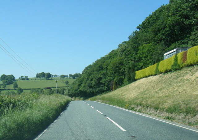
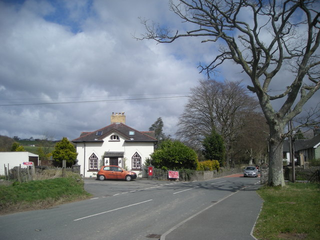
Bettws Bledrws is a small village located in the county of Cardiganshire, Wales. Situated in the beautiful rural landscape, it lies approximately 12 miles southeast of Cardigan and 7 miles northwest of Lampeter. The village is nestled in the Teifi Valley, known for its scenic views and rolling hills.

With a population of around 300 residents, Bettws Bledrws maintains a tight-knit community feel. The village is characterized by its picturesque charm, with traditional stone houses and cottage-style architecture. The nearby River Teifi adds to the village's natural beauty, offering opportunities for fishing and leisurely walks along its banks.

The village has a rich history, dating back many centuries. It is believed to have been founded during the medieval period, and remnants of ancient settlements and historic landmarks can still be found in the surrounding countryside. The St. Gwynog Church, a prominent feature of the village, stands as a testament to its long-standing heritage. Built in the 13th century, the church is known for its architectural significance and houses several interesting artifacts.

Despite its small size, Bettws Bledrws offers a range of amenities for its residents and visitors. These include a village hall, a primary school, a pub, and a community shop. The village also hosts various events throughout the year, fostering a sense of community and providing opportunities for social interaction.

Bettws Bledrws is a tranquil and idyllic village, offering a peaceful retreat from the hustle and bustle of modern life. Its stunning natural surroundings, historic charm, and close-knit community make it a delightful destination for visitors and a cherished home for its residents.

If you have any feedback on the listing, please let us know in the comments section below.

Bettws Bledrws Images

Images are sourced within 2km of 52.147739/-4.052691 or Grid Reference SN5951. Thanks to Geograph Open Source API. All images are credited.

Derry Ormond Tower <span class="nowrap"><a title="https://en.wikipedia.org/wiki/Derry_Ormond_Tower" rel="nofollow ugc noopener" href="https://en.wikipedia.org/wiki/Derry_Ormond_Tower">Link</a><img style="margin-left:2px;" alt="External link" title="External link - shift click to open in new window" src="https://s1.geograph.org.uk/img/external.png" width="10" height="10"/></span>
Derry Ormond Tower
Ordnance Survey Cut Mark This OS cut mark can be found on the gatepost SE side of the road. It marks a point 187.577m above mean sea level.
Ordnance Survey Cut Mark
This OS cut mark can be found on the gatepost SE side of the road. It marks a point 187.577m above mean sea level.
Ordnance Survey Cut Mark This OS cut mark can be found on the churn stand SE side of the road. It marks a point 205.060m above mean sea level. <a title="https://www.geograph.org.uk/photo/7412309" href="https://www.geograph.org.uk/photo/7412309">Link</a>
Ordnance Survey Cut Mark
This OS cut mark can be found on the churn stand SE side of the road. It marks a point 205.060m above mean sea level. Link
Churn Stand There is an Ordnance Survey cut mark on the front of the stand. <a title="https://www.geograph.org.uk/photo/7412304" href="https://www.geograph.org.uk/photo/7412304">Link</a>
Churn Stand
There is an Ordnance Survey cut mark on the front of the stand. Link
Ordnance Survey Cut Mark This OS cut mark can be found on the churn stand east side of the road. It marks a point 141.877m above mean sea level. <a title="https://www.geograph.org.uk/photo/7412328" href="https://www.geograph.org.uk/photo/7412328">Link</a>
Ordnance Survey Cut Mark
This OS cut mark can be found on the churn stand east side of the road. It marks a point 141.877m above mean sea level. Link
Churn Stand There is an Ordnance Survey cut mark on the front of the stand. <a title="https://www.geograph.org.uk/photo/7412325" href="https://www.geograph.org.uk/photo/7412325">Link</a>
Churn Stand
There is an Ordnance Survey cut mark on the front of the stand. Link
Ordnance Survey Cut Mark This OS cut mark can be found on Bryn Madog Bach. It marks a point 198.940m above mean sea level.
Ordnance Survey Cut Mark
This OS cut mark can be found on Bryn Madog Bach. It marks a point 198.940m above mean sea level.
Ordnance Survey Cut Mark This OS cut mark can be found on the gatepost SW side of the road. It marks a point 198.297m above mean sea level.
Ordnance Survey Cut Mark
This OS cut mark can be found on the gatepost SW side of the road. It marks a point 198.297m above mean sea level.
Ordnance Survey Cut Mark This OS cut mark can be found on the gatepost south side of the road. It marks a point 189.311m above mean sea level.
Ordnance Survey Cut Mark
This OS cut mark can be found on the gatepost south side of the road. It marks a point 189.311m above mean sea level.
Ordnance Survey Cut Mark This OS cut mark can be found on the SW angle of St Bledrws' Church. It marks a point 133.707m above mean sea level.
Ordnance Survey Cut Mark
This OS cut mark can be found on the SW angle of St Bledrws' Church. It marks a point 133.707m above mean sea level.
Ordnance Survey Flush Bracket (G3325) This OS Flush Bracket can be found on the roadside barn at Bettws Farm. It marks a point 133.651m above mean sea level.
Ordnance Survey Flush Bracket (G3325)
This OS Flush Bracket can be found on the roadside barn at Bettws Farm. It marks a point 133.651m above mean sea level.
A485 in Betws Bledrws
A485 by Bettws Plantation
A485 at Allt Coed Parc
Ordnance Survey Flush Bracket G3326 This can be found on the roadside wall of a building at Glan-Denys.
For more detail see : <span class="nowrap"><a title="http://www.bench-marks.org.uk/bm10589" rel="nofollow ugc noopener" href="http://www.bench-marks.org.uk/bm10589">Link</a><img style="margin-left:2px;" alt="External link" title="External link - shift click to open in new window" src="https://s1.geograph.org.uk/img/external.png" width="10" height="10"/></span>
Ordnance Survey Flush Bracket G3326
This can be found on the roadside wall of a building at Glan-Denys. For more detail see : LinkExternal link
Ordnance Survey Fundamental Bench Mark - Lampeter Although several miles from Lampeter this can be found on the roadside verge near Pen-y-coed uchaf.
For more detail see : <span class="nowrap"><a title="http://www.bench-marks.org.uk/bm1096" rel="nofollow ugc noopener" href="http://www.bench-marks.org.uk/bm1096">Link</a><img style="margin-left:2px;" alt="External link" title="External link - shift click to open in new window" src="https://s1.geograph.org.uk/img/external.png" width="10" height="10"/></span>
Ordnance Survey Fundamental Bench Mark - Lampeter
Although several miles from Lampeter this can be found on the roadside verge near Pen-y-coed uchaf. For more detail see : LinkExternal link
Ordnance Survey Cut Mark This can be found on a roadside building at Pen-coe isaf.
For more detail see : <span class="nowrap"><a title="http://www.bench-marks.org.uk/bm71818" rel="nofollow ugc noopener" href="http://www.bench-marks.org.uk/bm71818">Link</a><img style="margin-left:2px;" alt="External link" title="External link - shift click to open in new window" src="https://s1.geograph.org.uk/img/external.png" width="10" height="10"/></span>
Ordnance Survey Cut Mark
This can be found on a roadside building at Pen-coe isaf. For more detail see : LinkExternal link
Derry Ormond Tower Viewed from the north.
Derry Ormond Tower
Viewed from the north.
Show me another place!

Bettws Bledrws is located at Grid Ref: SN5951 (Lat: 52.147739, Lng: -4.052691)

Unitary Authority: Ceredigion

Police Authority: Dyfed Powys

Also known as: Betws Bledrws

What 3 Words

///courts.cabs.plod. Near Llangybi, Ceredigion

Related Wikis

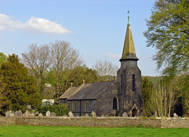
Betws Bledrws Church

The present church of St Bledrws, in the village of Betws Bledrws (sometimes spelt Bettws Bledrws), near Lampeter, Ceredigion, Wales, is a 19th-century...

Betws Bledrws

Betws Bledrws, is a village between Lampeter and Llangybi, Ceredigion, Wales that was also known as Derry Ormond when under the influence of Derry Ormond...

Derry Ormond railway station

Derry Ormond railway station served the hamlet and rural locale of Betws Bledrws near Llangybi, as well as the mansion and estate of Derry Ormond (demolished...
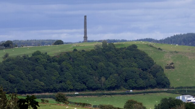
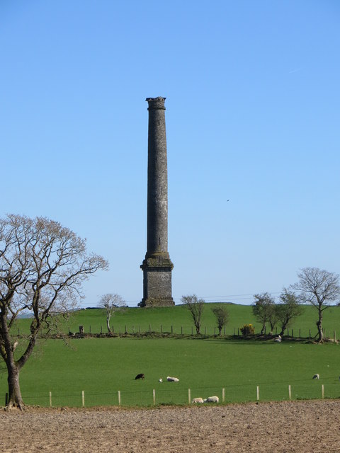
Derry Ormond Tower

Derry Ormond Tower is a Grade II*-listed folly situated above Betws Bledrws, 3 miles (4.8 km) north of Lampeter in the county of Ceredigion, Wales. It...

Derry Ormond

Derry Ormond is a farm and a small village in the community of Llangybi, Ceredigion, Wales, which is 60.1 miles (96.7 km) from Cardiff and 173.8 miles...

Llangybi railway station (Ceredigion)

Llangybi railway station, previously served the village and rural locale of Llangybi on the Carmarthen Aberystwyth Line in the Welsh county of Ceredigion...

Llangybi, Ceredigion

Llangybi is a village and parish in the south of Ceredigion, Wales. It is located on the A485 between Tregaron to the north and Lampeter to the south,...

Caeau Llety-cybi

Caeau Llety-cybi is a Site of Special Scientific Interest in Ceredigion, west Wales. The lowland meadow site is managed by the Wildlife Trust of South...

Nearby Amenities

Located within 500m of 52.147739,-4.052691
Betws Bledrws
Is In: Ceredigion, Wales, UK
Name Cy: Betws Bledrws
Place: village
Source: npe
Lat/Long: 52.1489931/-4.0538611
Derry-Ormond
Abandoned Railway: station
Old Name: Bettws
Railway: site
Source: OS 1:25k
Wikidata: Q5263205
Wikipedia: en:Derry Ormond railway station
Lat/Long: 52.143586/-4.0511072
Bus Stop
Bus: yes
Public Transport: platform
Lat/Long: 52.148514/-4.0555485
Bus Stop
Bus: yes
Public Transport: platform
Lat/Long: 52.1487538/-4.0547972
Direction: 255
Generator Method: photovoltaic
Generator Output Electricity: yes
Generator Solar Modules: 16
Generator Source: solar
Generator Type: solar_photovoltaic_panel
Location: roof
Power: generator
Lat/Long: 52.1480893/-4.0568599
Telephone
Booth: K6
Covered: booth
Listed Status: Grade II
Operator: BT
Phone: +44 1570 493319
Lat/Long: 52.1489839/-4.0539245
Post Box
Post Box Type: wall
Royal Cypher: GR
Royal Cypher Wikidata: Q33102273
Lat/Long: 52.1489844/-4.0543281
The data included in this document is from www.openstreetmap.org. The data is made available under ODbL.

Have you been to Bettws Bledrws?

Leave your review of Bettws Bledrws below (or comments, questions and feedback).