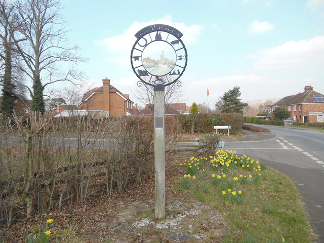
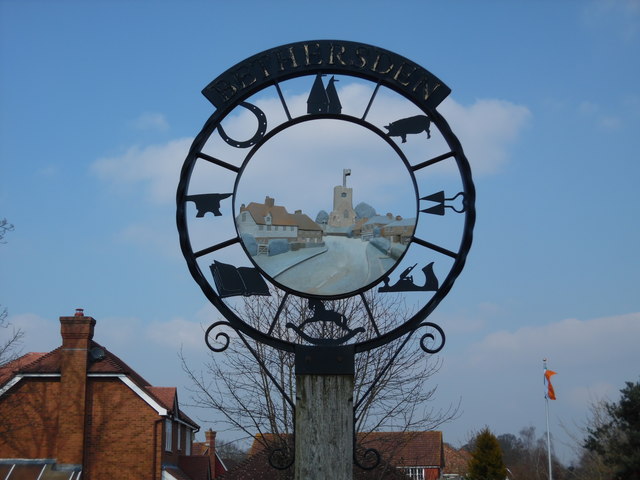
Bethersden

Settlement in Kent Ashford

England

Bethersden

Potter's Farm
Potter's Farm Credit: N Chadwick

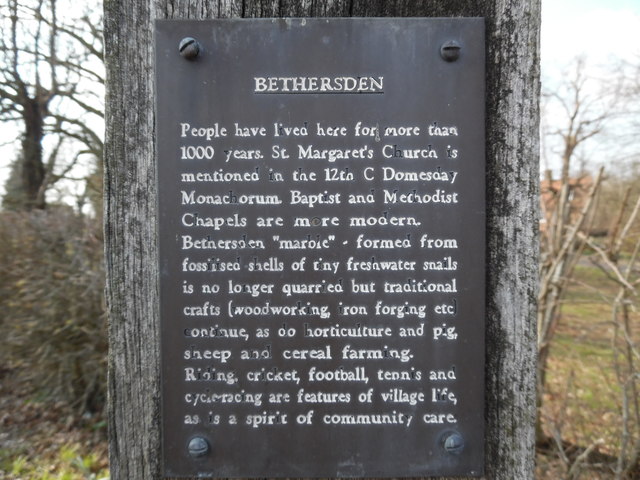
Bethersden is a picturesque village situated in the county of Kent, England. It is located approximately 12 miles south of Ashford and 10 miles east of Tenterden. With a population of around 1,400 residents, it is a small and tight-knit community.

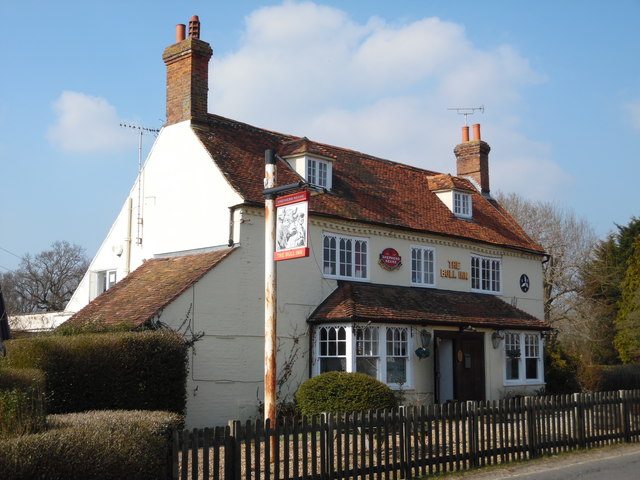
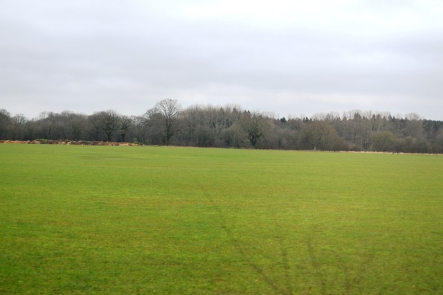
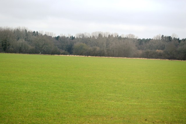
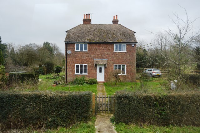
The village is known for its charming and well-preserved traditional houses, many of which date back to the 16th and 17th centuries. The local architecture is predominantly timber-framed, giving Bethersden a distinct historical ambiance. The village is surrounded by beautiful countryside, with rolling green fields and hedgerows adding to its scenic charm.

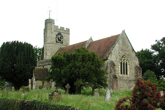
Bethersden is home to a few amenities, including a primary school, a village hall, and a local shop. The village also boasts two historic churches, St. Margaret's and St. Mary's, both of which are worth visiting for their architectural beauty and historical significance.

Agriculture has traditionally played a significant role in the local economy, with farming being a common occupation among the villagers. However, like many rural communities, Bethersden has seen a shift towards a more diverse economy with a range of employment opportunities available.

The village is well-connected to the surrounding areas by road, making it easily accessible for both residents and visitors alike. Its rural location offers a peaceful and close-knit community atmosphere, making Bethersden an attractive place to live or visit for those seeking a slower pace of life and a taste of traditional English village charm.

If you have any feedback on the listing, please let us know in the comments section below.
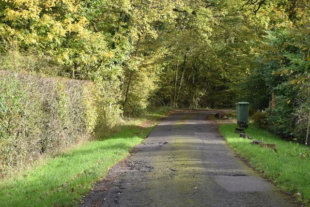
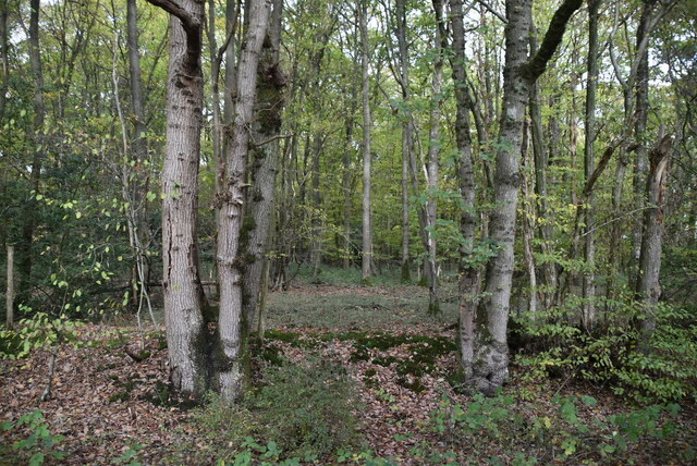
Bethersden Images

Images are sourced within 2km of 51.129173/0.755461 or Grid Reference TQ9240. Thanks to Geograph Open Source API. All images are credited.

Potter's Farm
Potter's Farm
Brissenden Green Lane
Woodlands
Woodlands
Brissenden Green Lane
Twenty Acre Wood
Twenty Acre Wood
Twenty Acre Wood
Twenty Acre Wood
Footpath off Brissenden Green Lane
Bethersden Village Sign This sign was erected for the Millennium and is located in School Road near the junction with the A28 Ashford Road. School Road can be seen to the right of the photo whilst behind the sign, Whiston Avenue branches off School Road.
Bethersden Village Sign
This sign was erected for the Millennium and is located in School Road near the junction with the A28 Ashford Road. School Road can be seen to the right of the photo whilst behind the sign, Whiston Avenue branches off School Road.
Close Up of the Bethersden Village Sign This photo shows the eight symbols round the sign with St Margaret's Parish Church  and a few houses in its centre.
Close Up of the Bethersden Village Sign
This photo shows the eight symbols round the sign with St Margaret's Parish Church and a few houses in its centre.
Notice on Bethersden Village Sign (1) This photo shows one of four notices on the Bethersden Village Sign. It says the following:
                                  BETHERSDEN

People have lived here for more than 1000 years. St Margaret's Church is mentioned  in the 12th C Domesday Monachorum. Baptist and Methodist Chapels are more modern.
Bethersden "marble" - formed from fossilised shells of tiny freshwater snails is no longer quarried but traditional crafts (woodworking, iron forging etc) continue, as do horticulture and pig, sheep and cereal farming.
Riding, cricket, football, tennis and cycle-racing are features of village life, as is a spirit of community care.
Notice on Bethersden Village Sign (1)
This photo shows one of four notices on the Bethersden Village Sign. It says the following: BETHERSDEN People have lived here for more than 1000 years. St Margaret's Church is mentioned in the 12th C Domesday Monachorum. Baptist and Methodist Chapels are more modern. Bethersden "marble" - formed from fossilised shells of tiny freshwater snails is no longer quarried but traditional crafts (woodworking, iron forging etc) continue, as do horticulture and pig, sheep and cereal farming. Riding, cricket, football, tennis and cycle-racing are features of village life, as is a spirit of community care.
Notice on Bethersden Village Sign (2) This photo shows one of the four notices on the Bethersden village sign in School Road near the A28 Ashford Road. It has the following wording:

                                BETHERSDEN
                              MILLENNIUM SIGN

 The material in this sign - iron, oak and a limestone "marble" - and the symbols all relate to activities for which Bethersden is famous. The plaque is a montage of features in the village centre.
 The sign was designed by residents and built by local craftsmen with a grant from Ashford Borough Council. Beneath the base, a Time Capsule is buried - to be opened no sooner than 2100 AD.
Notice on Bethersden Village Sign (2)
This photo shows one of the four notices on the Bethersden village sign in School Road near the A28 Ashford Road. It has the following wording: BETHERSDEN MILLENNIUM SIGN The material in this sign - iron, oak and a limestone "marble" - and the symbols all relate to activities for which Bethersden is famous. The plaque is a montage of features in the village centre. The sign was designed by residents and built by local craftsmen with a grant from Ashford Borough Council. Beneath the base, a Time Capsule is buried - to be opened no sooner than 2100 AD.
Notice on Bethersden Village Sign (3) This photo shows one of the four notices on the Bethersden village sign in School Road near the A28 Ashford Road. It says the following:
     
                              THE SIGN SYMBOLS

 OAST HOUSES -  hop farming area until 1970s
 ROCKING HORSE - Stevenson Brothers export them all over the world
 ANVIL -  forges in the parish still operational
 BOOK -  Richard Lovelace, 17th C Cavalier Poet, owned land in Bethersden. He           wrote: "Stone walls do not a prison make
        Nor i'ron bars a cage"
 PLANE - village's wood craftmanship renowned.
 SHEARS - sheep farming commercially important.
 PIG - 1086 village named "Beadericesdenne". "denne" meant woodland where swine   are pastured
Notice on Bethersden Village Sign (3)
This photo shows one of the four notices on the Bethersden village sign in School Road near the A28 Ashford Road. It says the following: THE SIGN SYMBOLS OAST HOUSES - hop farming area until 1970s ROCKING HORSE - Stevenson Brothers export them all over the world ANVIL - forges in the parish still operational BOOK - Richard Lovelace, 17th C Cavalier Poet, owned land in Bethersden. He wrote: "Stone walls do not a prison make Nor i'ron bars a cage" PLANE - village's wood craftmanship renowned. SHEARS - sheep farming commercially important. PIG - 1086 village named "Beadericesdenne". "denne" meant woodland where swine are pastured
Notice on Bethersden Village Sign (4) This notice is one of four on the Betherden Village Sign and lists the acknowledgements to those who were responsible for the sign being erected for the Millennium. Included on that list is the Bethersden "Marble" donated by 44 residents.
Notice on Bethersden Village Sign (4)
This notice is one of four on the Betherden Village Sign and lists the acknowledgements to those who were responsible for the sign being erected for the Millennium. Included on that list is the Bethersden "Marble" donated by 44 residents.
The Bull Inn, Bethersden Situated on the A28 road at Bull Hill, this inn dates from 1645. Later, its stables were used as a prison and the local Home Guard occupied the Inn for training during World War 2. It now provides food and drink daily, and has a garden and car parking space. For SatNav purposes, its postcode is TN26 3LB.
The Bull Inn, Bethersden
Situated on the A28 road at Bull Hill, this inn dates from 1645. Later, its stables were used as a prison and the local Home Guard occupied the Inn for training during World War 2. It now provides food and drink daily, and has a garden and car parking space. For SatNav purposes, its postcode is TN26 3LB.
Track off Bull Lane
Track off Bull Lane
Field by Bull Lane
Field by Bull Lane
Pasture by Bull Lane
Cottage on Bull Lane
Show me another place!

Bethersden is located at Grid Ref: TQ9240 (Lat: 51.129173, Lng: 0.755461)

Administrative County: Kent

District: Ashford

Police Authority: Kent

What 3 Words

///community.prefer.kings. Near High Halden, Kent

Nearby Locations

Bethersden Bethersden

Related Wikis

Bethersden

Bethersden is a village and civil parish in the borough of Ashford in Kent, England, 5 miles (8 km) west of the town of Ashford. Located on the main road...

Pluckley railway station

Pluckley railway station is on the South Eastern Main Line in England, serving the village of Pluckley, Kent, which is approximately 1.2 miles (2 km) to...

National Cycle Route 18

National Cycle Route 18 (NCR18) runs from Canterbury to Royal Tunbridge Wells. It follows the valley of the River Stour to Ashford and then runs through...

Hoad's Wood

Hoad's Wood is an 80.5-hectare (199-acre) biological Site of Special Scientific Interest west of Ashford in Kent.Natural England described the woodland...
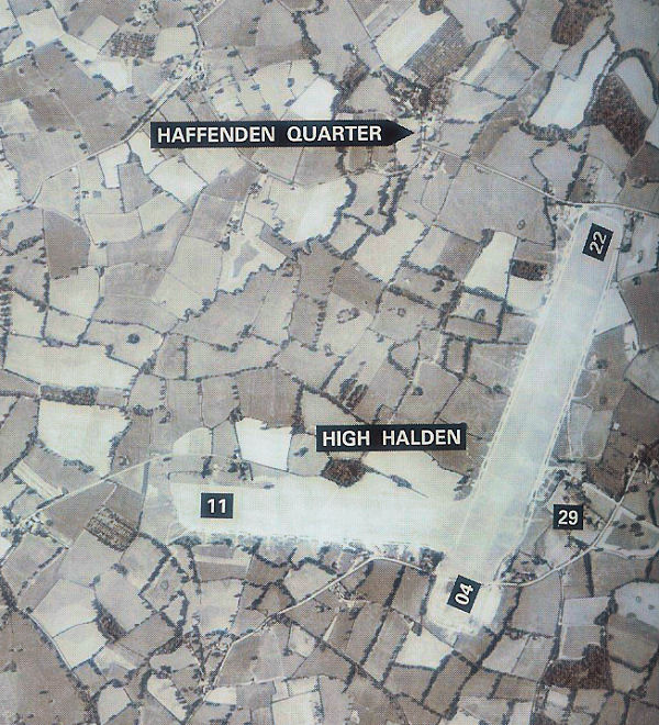
RAF High Halden

Royal Air Force High Halden or more simply RAF High Halden is a former Royal Air Force Advanced Landing Ground in Kent, England. The airfield is located...

High Halden

High Halden is a village and civil parish in the Ashford District of Kent, England. The village is on the A28 road between Ashford and Tenterden, 3 miles...

RAF Ashford

Royal Air Force Ashford or more simply RAF Ashford is a former Royal Air Force Advanced Landing Ground in Kent, England. The landing ground is located...

RAF Woodchurch

Royal Air Force Woodchurch, or more simply RAF Woodchurch, is a former Royal Air Force Advanced Landing Ground located in Kent, England. The airfield...

Nearby Amenities

Located within 500m of 51.129173,0.755461
Bethersden
Is In: Kent, England, UK
Place: village
Postal Code: TN26
Lat/Long: 51.1272487/0.7527886
Bus Stop
Ironworks
Flag: no
Naptan AtcoCode: 2400100001
Naptan Bearing: E
Naptan BusStopType: CUS
Naptan CommonName: Ironworks
Naptan Indicator: opp
Naptan Landmark: Ironworks
Naptan NaptanCode: kntgwagm
Naptan Street: Ashford Road
Naptan Verified: no
Public Transport: platform
Ref: kntgwagm
Source: naptan_import
Source Date: 2018-05-02T15:22:00
Lat/Long: 51.1261695/0.759318
Bus Stop
School
Naptan AtcoCode: 240099970
Naptan Bearing: SW
Naptan BusStopType: MKD
Naptan CommonName: School
Naptan Indicator: opp
Naptan Landmark: School
Naptan NaptanCode: kntgptpa
Naptan Street: Church Hill
Public Transport: platform
Ref: kntgptpa
Shelter: no
Source: naptan_import
Source Date: 2018-05-02T15:26:00
Tactile Paving: no
Lat/Long: 51.1279551/0.7511056
Bus Stop
School
Flag: no
Naptan AtcoCode: 240099972
Naptan Bearing: NE
Naptan BusStopType: CUS
Naptan CommonName: School
Naptan Indicator: adj
Naptan Landmark: School
Naptan NaptanCode: kntgptjm
Naptan Street: Church Hill
Naptan Verified: no
Public Transport: platform
Ref: kntgptjm
Shelter: no
Source: naptan_import
Source Date: 2018-05-02T15:27:00
Tactile Paving: no
Lat/Long: 51.1280579/0.7509402
Bus Stop
The Dene
Bench: yes
Bin: no
Fixme: Is there really a shelter here?
Lit: yes
Local Ref: adj
Naptan AtcoCode: 240099974
Naptan Bearing: NE
Naptan BusStopType: CUS
Naptan CommonName: The Dene
Naptan Indicator: adj
Naptan Landmark: The Dene
Naptan NaptanCode: kntgptjd
Naptan Status: act
Naptan Street: Forge Hill
Naptan Verified: no
Public Transport: platform
Ref: kntgptjd
Shelter: yes
Source: naptan_import
Source Date: 2018-05-02
Tactile Paving: no
Lat/Long: 51.1273176/0.756785
Bus Stop
The Dene
Bench: no
Flag: no
Naptan AtcoCode: 240099976
Naptan Bearing: SW
Naptan BusStopType: CUS
Naptan CommonName: The Dene
Naptan Indicator: opp
Naptan Landmark: The Dene
Naptan NaptanCode: kntgptjg
Naptan Street: Forge Hill
Naptan Verified: no
Public Transport: platform
Ref: kntgptjg
Shelter: no
Source: naptan_import
Source Date: 2018-05-02T15:34:00
Tactile Paving: no
Lat/Long: 51.1272061/0.7569356
Bus Stop
Ironworks
Flag: no
Naptan AtcoCode: 240099978
Naptan Bearing: NW
Naptan BusStopType: CUS
Naptan CommonName: Ironworks
Naptan Indicator: adj
Naptan Landmark: Ironworks
Naptan NaptanCode: kntgptgw
Naptan Street: Ashford Road
Naptan Verified: no
Public Transport: platform
Ref: kntgptgw
Source: naptan_import
Source Date: 2018-05-02T15:21:00
Lat/Long: 51.1260751/0.7591265
Bus Stop
The George
Naptan AtcoCode: 2400A037320A
Naptan Bearing: W
Naptan CommonName: The George
Naptan Indicator: adj
Naptan Landmark: Post Office
Naptan NaptanCode: kntdpadt
Naptan Street: The Street
Naptan Verified: no
Public Transport: platform
Ref: kntdpadt
Source: naptan_import
Source Date: 2018-05-02T15:38:00
Lat/Long: 51.129117/0.7552341
Bus Stop
The George
Bench: yes
Naptan AtcoCode: 2400A037330A
Naptan Bearing: E
Naptan CommonName: The George
Naptan Indicator: opp
Naptan Landmark: Post Office
Naptan NaptanCode: kntdpadw
Naptan Street: The Street
Naptan Verified: no
Public Transport: platform
Ref: kntdpadw
Shelter: yes
Source: naptan_import
Source Date: 2018-05-02T15:37:00
Tactile Paving: no
Lat/Long: 51.1293477/0.7557482
Post Office
Bethersden Post Office & Stores
Shop: convenience
Source: OS OpenData StreetView
Lat/Long: 51.1294182/0.7554968
Barrier: kissing_gate
Bicycle: no
Foot: yes
Lat/Long: 51.130607/0.7510109
Generator Method: photovoltaic
Generator Output Electricity: yes
Generator Source: solar
Generator Type: solar_photovoltaic_panel
Location: roof
Power: generator
Lat/Long: 51.1300388/0.7564822
Generator Method: photovoltaic
Generator Output Electricity: yes
Generator Source: solar
Generator Type: solar_photovoltaic_panel
Location: roof
Power: generator
Lat/Long: 51.1278455/0.7557312
Generator Method: photovoltaic
Generator Output Electricity: yes
Generator Source: solar
Generator Type: solar_photovoltaic_panel
Location: roof
Power: generator
Lat/Long: 51.1282766/0.7544264
Generator Method: photovoltaic
Generator Output Electricity: yes
Generator Source: solar
Generator Type: solar_photovoltaic_panel
Location: roof
Power: generator
Lat/Long: 51.1281771/0.7546771
Generator Method: photovoltaic
Generator Output Electricity: yes
Generator Source: solar
Generator Type: solar_photovoltaic_panel
Location: roof
Power: generator
Lat/Long: 51.127864/0.7537141
Generator Method: photovoltaic
Generator Output Electricity: yes
Generator Source: solar
Generator Type: solar_photovoltaic_panel
Location: roof
Power: generator
Lat/Long: 51.1277293/0.7540441
Generator Method: photovoltaic
Generator Output Electricity: yes
Generator Source: solar
Generator Type: solar_photovoltaic_panel
Location: roof
Power: generator
Lat/Long: 51.127322/0.7535639
Generator Method: photovoltaic
Generator Output Electricity: yes
Generator Source: solar
Generator Type: solar_photovoltaic_panel
Location: roof
Power: generator
Lat/Long: 51.1264466/0.7514235
Generator Method: photovoltaic
Generator Output Electricity: yes
Generator Source: solar
Generator Type: solar_photovoltaic_panel
Location: roof
Power: generator
Lat/Long: 51.1262733/0.7505612
Generator Method: photovoltaic
Generator Output Electricity: yes
Generator Source: solar
Generator Type: solar_photovoltaic_panel
Location: roof
Power: generator
Lat/Long: 51.1262034/0.7505371
Generator Method: photovoltaic
Generator Output Electricity: yes
Generator Source: solar
Generator Type: solar_photovoltaic_panel
Location: roof
Power: generator
Lat/Long: 51.1261268/0.7504794
Generator Method: photovoltaic
Generator Output Electricity: yes
Generator Source: solar
Generator Type: solar_photovoltaic_panel
Location: roof
Power: generator
Lat/Long: 51.1313251/0.7603629
Generator Method: photovoltaic
Generator Output Electricity: yes
Generator Source: solar
Generator Type: solar_photovoltaic_panel
Location: roof
Power: generator
Lat/Long: 51.131251/0.7602636
Generator Method: photovoltaic
Generator Output Electricity: yes
Generator Source: solar
Generator Type: solar_photovoltaic_panel
Location: roof
Power: generator
Lat/Long: 51.1311298/0.7597218
Generator Method: photovoltaic
Generator Output Electricity: yes
Generator Source: solar
Generator Type: solar_photovoltaic_panel
Location: roof
Power: generator
Lat/Long: 51.131177/0.7596414
Bus Stop
Cricket Pitch
Fixme: Can somebody confirm is there is a bus stop here?
Flag: no
Naptan AtcoCode: 2400105903
Naptan Bearing: E
Naptan BusStopType: CUS
Naptan CommonName: Cricket Pitch
Naptan Indicator: opp
Naptan Landmark: Cricket Pitch
Naptan NaptanCode: kntjtgta
Naptan Street: Ashford Road
Naptan Verified: no
Public Transport: platform
Ref: kntjtgta
Shelter: no
Source: NAPTAN
Source Date: 2018-05-02T15:19:00
Tactile Paving: no
Lat/Long: 51.1260876/0.750966
Bus Stop
Cricket Pitch
Fixme: Can somebody confirm is there is a bus stop here?
Flag: no
Naptan AtcoCode: 2400A070400A
Naptan Bearing: W
Naptan BusStopType: CUS
Naptan CommonName: Cricket Pitch
Naptan Indicator: adj
Naptan Landmark: Cricket Pitch
Naptan NaptanCode: kntgdgtm
Naptan Street: Ashford Road
Naptan Verified: no
Public Transport: platform
Ref: kntgdgtm
Shelter: no
Source: NAPTAN
Source Date: 2018-05-02T15:18:00
Tactile Paving: no
Lat/Long: 51.1259522/0.7509865
Post Box
Collection Times: Mo-Fr 17:00, Sa 11:00
Drive Through: no
Post Box Type: wall
Lat/Long: 51.1293784/0.7555423
Barrier: kissing_gate
Material: wood
Lat/Long: 51.1295283/0.7533715
Telephone
Booth: K6
Covered: booth
Listed Status: Grade II
Lat/Long: 51.1293811/0.7556004
Advertising: board
Lat/Long: 51.1293514/0.7556483
The data included in this document is from www.openstreetmap.org. The data is made available under ODbL.

Have you been to Bethersden?

Leave your review of Bethersden below (or comments, questions and feedback).