Noel Park

Settlement in Middlesex

England

Noel Park

Hornsey Vale : Stationers Park
Hornsey Vale : Stationers Park Credit: Jim Osley

Noel Park is a residential area located in the London Borough of Haringey, Middlesex, England. Situated approximately 8 miles north of central London, it is a vibrant and diverse community.

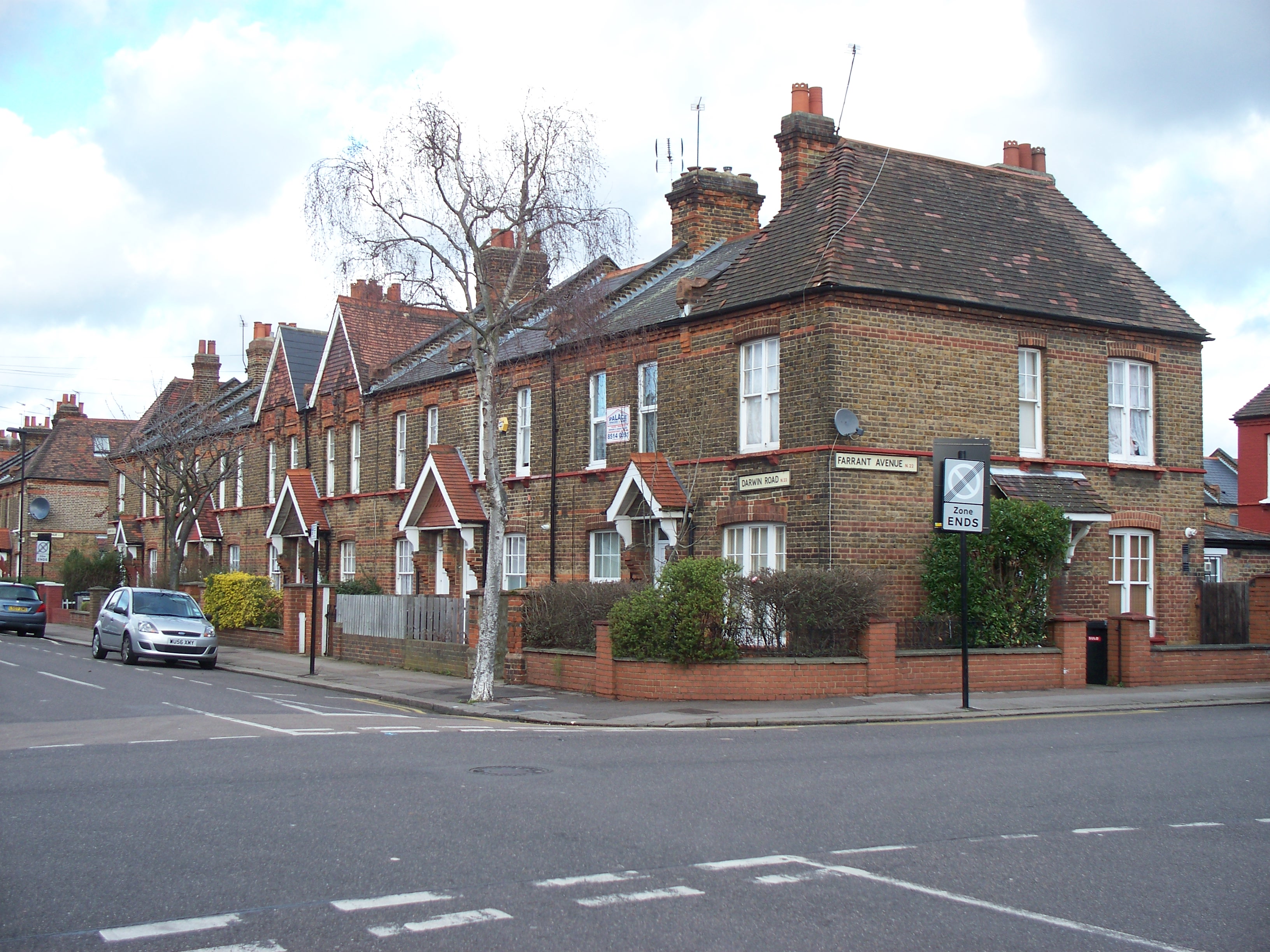
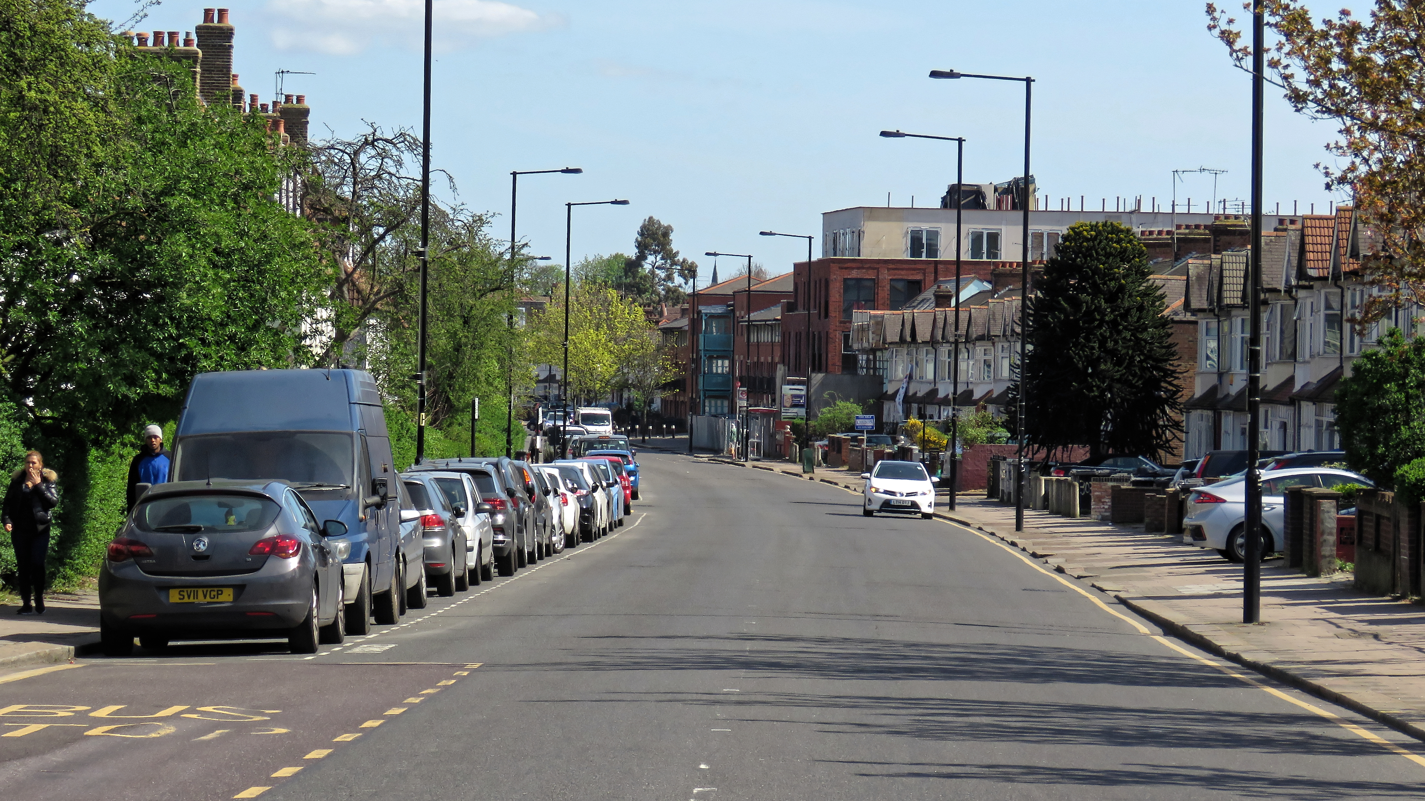
Originally developed in the late 19th century, Noel Park is known for its attractive Victorian architecture. The area is characterized by rows of terraced houses, many of which have been well-preserved and retain their original features. The streets are lined with trees, creating a pleasant and leafy environment.

Noel Park is home to a diverse population, with a mix of families, professionals, and students. The community is known for its friendly atmosphere and strong sense of community spirit. Residents have access to various amenities, including schools, parks, and local shops.

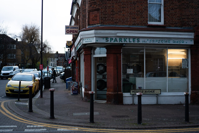
One of the notable features of Noel Park is its proximity to Wood Green, a major commercial and entertainment hub in the borough. This offers residents a wide range of shopping, dining, and entertainment options, including the popular Wood Green Shopping City.

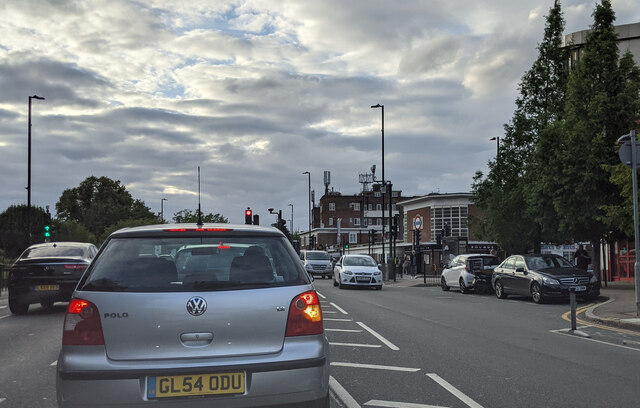
Transport links in Noel Park are excellent. The area benefits from several bus routes connecting it to surrounding neighborhoods and central London. Wood Green Underground Station, served by the Piccadilly Line, is within walking distance, providing quick and easy access to the city center.

Overall, Noel Park, Middlesex is a desirable place to live, offering a combination of historical charm, a strong community spirit, and convenient access to amenities and transport links.

If you have any feedback on the listing, please let us know in the comments section below.

Noel Park Images

Images are sourced within 2km of 51.596127/-0.1013 or Grid Reference TQ3190. Thanks to Geograph Open Source API. All images are credited.

Hornsey Vale : Stationers Park
Alexandra Park : New River bridge
Parked on Park Avenue
On Bounds Green Road approaching junction with Brownlow Road
Path through Alexandra Park Leading up to the palace
Path through Alexandra Park
Leading up to the palace
Path through Alexandra Park
Woodlands in Alexandra Park
Wood Green : New River At this point the New River disappears underground until it emerges at Bowes Park.
Wood Green : New River
At this point the New River disappears underground until it emerges at Bowes Park.
Wood Green : Eldon Road Baptist Church Built 1935-1936 to a design by architect Frederick George Faunch (1863-1945).
Wood Green : Eldon Road Baptist Church
Built 1935-1936 to a design by architect Frederick George Faunch (1863-1945).
Look right rainbow crossing at Wood Green with The Nag's Head pub Look right rainbow crossing at Wood Green with The Nag's Head pub in the background.
Look right rainbow crossing at Wood Green with The Nag's Head pub
Look right rainbow crossing at Wood Green with The Nag's Head pub in the background.
Old Course of the Moselle at Lordship Lane Rec Tottenham When the Moselle was de-culverted its course was moved slightly to the north. The line of the old course has filled with water and frozen over in this shot. One can imagine it as it was one hundred and fifty years ago.
Old Course of the Moselle at Lordship Lane Rec Tottenham
When the Moselle was de-culverted its course was moved slightly to the north. The line of the old course has filled with water and frozen over in this shot. One can imagine it as it was one hundred and fifty years ago.
The Antwerp Arms, Tottenham The Antwerp Arms pub in a residential neighbourhood in Tottenham, in the suburbs of north London.  This image was taken as darkness fell on a wet and gloomy December afternoon.
The Antwerp Arms, Tottenham
The Antwerp Arms pub in a residential neighbourhood in Tottenham, in the suburbs of north London. This image was taken as darkness fell on a wet and gloomy December afternoon.
Entrance to the car park on Lymington Avenue
Sparkles Laundrette on corner of Vincent Road and Moselle Avenue
Wood Green Crown Court
Lymington Avenue in Noel Park
Loading bay of Wood Green Shopping City off Mayes Road
Show me another place!

Noel Park is located at Grid Ref: TQ3190 (Lat: 51.596127, Lng: -0.1013)

Unitary Authority: Haringey

Police Authority: Metropolitan

What 3 Words

///first.image.again. Near Wood Green, London

Nearby Locations

Noel Park

Related Wikis

Noel Park

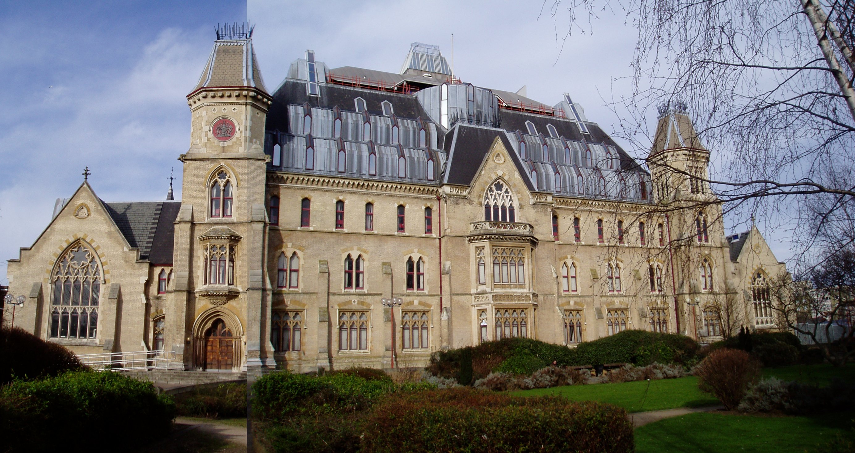
Noel Park in north London is a planned community built in the late 19th and early 20th centuries consisting of 2,200 model dwellings, designed by Rowland...

Wood Green Crown Court

Wood Green Crown Court is a Crown Court venue which deals with criminal cases on Lordship Lane, Wood Green, London, England. == History == The first building...

Noel Park and Wood Green railway station

Noel Park and Wood Green is a closed railway station on the Palace Gates Line in Wood Green, north London. It was located on the north-east side of The...

The Mall Wood Green

The Mall Wood Green is a large shopping centre and residential complex in Wood Green, north London. It was originally known as Wood Green Shopping City...

London Turkish Radio

London Turkish Radio (LTR) is a Turkish radio station specialising in music, news, and politics. It broadcast to London on 1584 kHz AM from 1990 to 2013...

Slave Labour (mural)

Slave Labour is a mural that was painted by a British graffiti artist, Banksy, on the side wall of a Poundland store in Wood Green, London in May 2012...

Lordship Lane, Haringey

Lordship Lane connects Wood Green (N22) with Tottenham High Road (N17). It lies in the London Borough of Haringey and forms part of the A109 road. ��2...

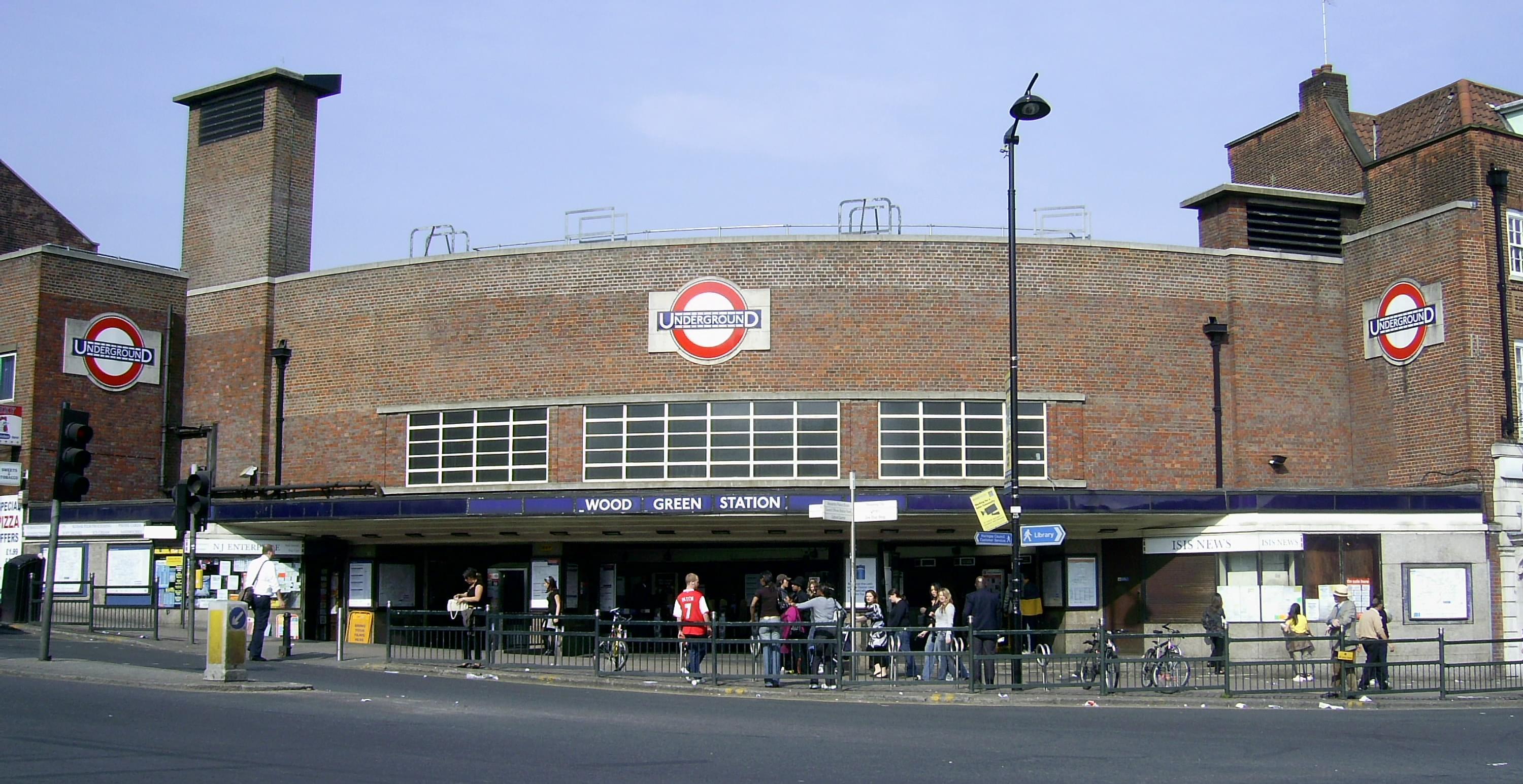
Wood Green tube station

Wood Green is a London Underground station on the Piccadilly line. The station is between Turnpike Lane and Bounds Green stations and is in Travelcard...

Nearby Amenities

Located within 500m of 51.596127,-0.1013
Redvers Road
Bus: yes
Local Ref: V
Public Transport: stop_position
Lat/Long: 51.5975353/-0.1075046
Wood Green Crown Court
Bus: yes
Local Ref: NT
Public Transport: stop_position
Lat/Long: 51.5983846/-0.1045873
Crossing
Crossing: unmarked
Crossing Island: yes
Lat/Long: 51.5997019/-0.1008595
Traffic Calming: hump
Lat/Long: 51.5982234/-0.1074943
Mini Roundabout
Lat/Long: 51.5951365/-0.105104
Traffic Calming: hump
Lat/Long: 51.5965784/-0.1027355
Traffic Calming: table
Lat/Long: 51.5965614/-0.1009012
Traffic Calming: table
Lat/Long: 51.5981969/-0.0962557
Traffic Calming: hump
Lat/Long: 51.595613/-0.0968617
Traffic Calming: hump
Lat/Long: 51.5945611/-0.1014349
Traffic Calming: hump
Lat/Long: 51.5966585/-0.0987137
Traffic Calming: table
Lat/Long: 51.5960496/-0.100444
Ref GB Tflcid: RWG288331
Traffic Calming: hump
Lat/Long: 51.5951093/-0.1041461
Crossing
Crossing: unmarked
Lat/Long: 51.5958766/-0.1078864
Ref GB Tflcid: RWG288891
Traffic Calming: table
Lat/Long: 51.5938935/-0.1061227
Ref GB Tflcid: RWG288336
Traffic Calming: hump
Lat/Long: 51.5926803/-0.1043354
Ref GB Tflcid: RWG287955
Traffic Calming: hump
Lat/Long: 51.5919314/-0.1034465
Traffic Calming: hump
Lat/Long: 51.5930442/-0.1011345
Traffic Signals
Lat/Long: 51.5981494/-0.0949289
Traffic Calming: hump
Lat/Long: 51.5939418/-0.0999331
Parking
Created By: Potlatch alpha
Lat/Long: 51.5949601/-0.1080728
Telephone
Booth: KXPlus
Covered: booth
Lat/Long: 51.5926624/-0.1058109
Post Box
Operator: Royal Mail
Operator Wikidata: Q638098
Ref: N22 17
Lat/Long: 51.5970644/-0.0960652
Post Box
Operator: Royal Mail
Operator Wikidata: Q638098
Ref: N22 34
Lat/Long: 51.5956155/-0.1000991
Post Box
Operator: Royal Mail
Operator Wikidata: Q638098
Ref: N22 24
Lat/Long: 51.5979299/-0.1020982
Post Box
Operator: Royal Mail
Operator Wikidata: Q638098
Ref: N22 23
Lat/Long: 51.6003996/-0.099834
Post Box
Operator: Royal Mail
Operator Wikidata: Q638098
Ref: N22 18
Lat/Long: 51.5988911/-0.0980483
Post Box
Operator: Royal Mail
Operator Wikidata: Q638098
Ref: N22 16
Lat/Long: 51.5975186/-0.1077501
Post Box
Ref: N22 9D
Lat/Long: 51.5955605/-0.1039543
Traffic Calming: hump
Lat/Long: 51.5931507/-0.0998096
Traffic Calming: hump
Lat/Long: 51.5935155/-0.0990991
Pub
The Westbury
Addr City: London
Addr Housenumber: 57
Addr Postcode: N22 6SA
Addr Street: Westbury Avenue
Brewery: various
Check Date: 2024-05-11
Food: yes
Indoor Seating: yes
Outdoor Seating: yes
Phone: +44 20 8889 2059
Smoking: outside
Lat/Long: 51.5935/-0.098389
Bus Stop
Lordship Lane
Local Ref: NE
Naptan AtcoCode: 490004186N
Naptan Bearing: N
Naptan CommonName: Boundary Road Lordship Lane
Naptan Indicator: Stop NE
Naptan Street: BOREHAM ROAD
Naptan Verified: no
Public Transport: platform
Lat/Long: 51.5976242/-0.0949144
Bus Stop
Gladstone Avenue
Local Ref: NC
Naptan AtcoCode: 490007201E
Naptan Bearing: E
Naptan CommonName: Morley AvenueGladstone Avenue
Naptan Indicator: Stop NC
Naptan Street: LORDSHIP LANE
Naptan Verified: no
Public Transport: platform
Wheelchair: yes
Lat/Long: 51.5985327/-0.0965235
Bus Stop
Gladstone Avenue
Local Ref: NP
Naptan AtcoCode: 490007201W
Naptan Bearing: W
Naptan CommonName: Morley AvenueGladstone Avenue
Naptan Indicator: Stop NP
Naptan Street: LORDSHIP LANE
Naptan Verified: no
Public Transport: platform
Wheelchair: yes
Lat/Long: 51.5981426/-0.0955533
Bus Stop
Brampton Park Road
Bench: yes
Local Ref: K
Naptan AtcoCode: 490009461K
Naptan Bearing: N
Naptan CommonName: Brampton Park Road
Naptan Indicator: Stop K
Naptan Street: HIGH ROAD
Naptan Verified: no
Public Transport: platform
Ref: 54153
Shelter: yes
Lat/Long: 51.5931109/-0.1066415
Bus Stop
Brampton Park Road
Local Ref: KA
Naptan AtcoCode: 490009461KA
Naptan Bearing: S
Naptan CommonName: Brampton Park Road
Naptan Indicator: Stop KA
Naptan Street: WOOD GREEN HIGH ROAD
Naptan Verified: no
Public Transport: platform
Ref: 54309
Shelter: yes
Lat/Long: 51.5929285/-0.1063752
Bus Stop
Westbury Avenue Baptist Church
Bench: no
Bin: yes
Lit: yes
Naptan AtcoCode: 490008909E
Naptan Bearing: N
Naptan CommonName: Westbury Avenue Baptist Church
Naptan Verified: no
Public Transport: platform
Shelter: no
Tactile Paving: no
Lat/Long: 51.5938297/-0.0976705
Bus Stop
Westbury Avenue Baptist Church
Bench: no
Bin: yes
Lit: yes
Naptan AtcoCode: 490008909W
Naptan Bearing: N
Naptan CommonName: Westbury Avenue Baptist Church
Naptan Verified: no
Public Transport: platform
Shelter: no
Tactile Paving: no
Lat/Long: 51.5935466/-0.0978976
Bus Stop
Morley Avenue
Local Ref: NR
Naptan AtcoCode: 490010036W
Naptan Bearing: W
Naptan CommonName: Morley Avenue
Naptan Indicator: Stop NR
Naptan Street: LORDSHIP LANE
Naptan Verified: no
Public Transport: platform
Ref: 72923
Wheelchair: yes
Lat/Long: 51.5990703/-0.0982925
Bus Stop
Perth Road
Local Ref: NB
Naptan AtcoCode: 490010954E
Naptan Bearing: E
Naptan CommonName: Perth Road
Naptan Indicator: Stop NB
Naptan Street: LORDSHIP LANE
Naptan Verified: no
Public Transport: platform
Ref: 51168
Lat/Long: 51.5996503/-0.1002321
Bus Stop
Perth Road
Bench: yes
Bin: yes
Bus: yes
Check Date Shelter: 2023-07-01
Lit: yes
Local Ref: NS
Naptan AtcoCode: 490010954W
Naptan Bearing: W
Naptan CommonName: Perth Road
Naptan Indicator: Stop NS
Naptan Street: LORDSHIP LANE
Naptan Verified: no
Public Transport: platform
Ref: 71327
Shelter: yes
Tactile Paving: no
Lat/Long: 51.5992075/-0.1017667
Bus Stop
Solway Road
Bus: yes
Local Ref: NH
Naptan AtcoCode: 490012223E
Naptan Bearing: E
Naptan CommonName: Solway Road
Naptan Indicator: Stop NH
Naptan Street: PERTH ROAD
Naptan Verified: no
Public Transport: platform
Ref: 58524
Lat/Long: 51.5998658/-0.1007718
Bus Stop
Wood Green Crown Court
Bench: yes
Bin: yes
Bus: yes
Lit: yes
Local Ref: NA
Naptan AtcoCode: 490014853E
Naptan Bearing: E
Naptan CommonName: Wood Green Crown Court
Naptan Indicator: Stop NA
Naptan Street: LORDSHIP LANE
Naptan Verified: no
Public Transport: platform
Ref: 49881
Shelter: yes
Tactile Paving: no
Lat/Long: 51.5986572/-0.1038834
Bus Stop
Wood Green Crown Court
Bench: yes
Bin: yes
Bus: yes
Lit: yes
Local Ref: NT
Naptan AtcoCode: 490014853W
Naptan Bearing: W
Naptan CommonName: Wood Green Crown Court
Naptan Indicator: Stop NT
Naptan Street: LORDSHIP LANE
Naptan Verified: no
Public Transport: platform
Ref: 58611
Shelter: yes
Tactile Paving: no
Lat/Long: 51.5983444/-0.1045607
Bus Stop
Redvers Road
Bench: yes
Bin: no
Lit: yes
Local Ref: E
Naptan AtcoCode: 490015470E
Naptan Bearing: E
Naptan CommonName: Redvers Road
Naptan Indicator: Stop E
Naptan Street: LORDSHIP LANE
Naptan Verified: no
Public Transport: platform
Ref: 55589
Shelter: yes
Tactile Paving: no
Lat/Long: 51.5974617/-0.108155
Bus Stop
Redvers Road
Bench: yes
Bin: yes
Bus: yes
Lit: yes
Local Ref: V
Naptan AtcoCode: 490015470E1
Naptan Bearing: E
Naptan CommonName: Redvers Road
Naptan Indicator: Stop V
Naptan Verified: no
Public Transport: platform
Ref: 76926
Shelter: yes
Tactile Paving: no
Lat/Long: 51.5976092/-0.1076093
Dead Pub
The Freemasons
Lat/Long: 51.5990568/-0.102888
William Hill
Brand: William Hill
Brand Wikidata: Q4053147
Shop: bookmaker
Lat/Long: 51.599386/-0.1018299
Money Transfer
Western Union
Lat/Long: 51.5991446/-0.1025207
Dentist
Amber Dental Laboratory
Lat/Long: 51.5991763/-0.1024418
Ref GB Tflcid: RWG288323
Traffic Calming: hump
Lat/Long: 51.5977003/-0.1056512
Ref GB Tflcid: RWG287443
Traffic Calming: hump
Lat/Long: 51.5936358/-0.1015092
Street Lamp
Lamp Model: Philips MA50
Lamp Type: low_pressure_sodium
Light Count: 1
Source: Survey of 2019-04-20
Lat/Long: 51.5951178/-0.0952125
Street Lamp
Lamp Model: Philips MA50
Lamp Type: low_pressure_sodium
Light Count: 1
Source: Survey of 2019-04-20
Lat/Long: 51.5957542/-0.0948219
Barrier: bollard
Lat/Long: 51.5955172/-0.0950743
Leisure: playground
Lat/Long: 51.5951045/-0.097305
Leisure: fitness_station
Sport: fitness
Lat/Long: 51.5949995/-0.0977502
Noel Park
Is In: Wood Green
Landuse: residential
Place: neighbourhood
Wikidata: Q3877693
Wikipedia: en:Noel Park
Lat/Long: 51.5970269/-0.1009153
Traffic Calming: cushion
Lat/Long: 51.5979094/-0.096228
Traffic Calming: hump
Lat/Long: 51.5927647/-0.1005779
Barrier: cycle_barrier
Lat/Long: 51.594617/-0.1004572
Ref GB Tflcid: RWG287446
Traffic Calming: hump
Lat/Long: 51.5942286/-0.103206
JD Sports
Addr City: London
Addr Street: High Road
Addr Suburb: Wood Green
Brand: JD Sports
Brand Wikidata: Q6108019
Shop: sports
Wheelchair: yes
Lat/Long: 51.5928583/-0.1061038
Holland & Barrett
Addr City: London
Addr Country: GB
Addr Postcode: N22 6HL
Addr Street: High Road
Addr Suburb: Wood Green
Brand: Holland & Barrett
Brand Wikidata: Q5880870
Shop: health_food
Lat/Long: 51.592732/-0.1059251
Bank
Halifax
Addr City: London
Addr Country: GB
Addr Postcode: N22 6HH
Addr Street: High Road
Addr Suburb: Wood Green
Brand: Halifax
Brand Wikidata: Q3310164
Brand Wikipedia: en:Halifax (bank)
Wheelchair: yes
Lat/Long: 51.5930973/-0.1064693
4 Feet
Addr City: London
Addr Country: GB
Addr Postcode: N22 6HH
Addr Street: High Road
Addr Suburb: Wood Green
Shop: shoes
Lat/Long: 51.5930034/-0.1064803
Walk n Talk
Addr City: London
Addr Postcode: N22 6HH
Addr Street: High Road
Addr Suburb: Wood Green
Shop: electronics
Lat/Long: 51.5929994/-0.1063191
The Gym
Brand: The Gym
Brand Wikidata: Q48815022
Contact Website: https://www.thegymgroup.com/find-a-gym/north-london-gyms/wood-green-lordship-lane/
Leisure: fitness_centre
Lat/Long: 51.5972343/-0.1080958
Traffic Calming: hump
Lat/Long: 51.5940728/-0.1057339
Ref GB Tflcid: RWG287969
Traffic Calming: hump
Lat/Long: 51.5930803/-0.101897
Traffic Calming: hump
Lat/Long: 51.5942574/-0.1053265
Crossing
Crossing: uncontrolled
Lat/Long: 51.5938294/-0.1060423
Give Way
Direction: forward
Lat/Long: 51.59821/-0.0961314
Crossing
Bicycle: yes
Button Operated: yes
Crossing: traffic_signals
Crossing Island: no
Tactile Paving: yes
Lat/Long: 51.5982372/-0.0957867
Crossing
Crossing: unmarked
Crossing Island: yes
Tactile Paving: yes
Traffic Calming: table
Lat/Long: 51.5982624/-0.0961176
Give Way
Direction: backward
Lat/Long: 51.5982848/-0.0955628
Tactile Paving: yes
Lat/Long: 51.5982863/-0.0957475
Tactile Paving: yes
Lat/Long: 51.5982223/-0.0959215
Bench
Backrest: yes
Material: wood
Seats: 4
Lat/Long: 51.5998315/-0.1004695
Bench
Backrest: yes
Material: wood
Seats: 4
Lat/Long: 51.5999617/-0.1002876
Bench
Backrest: yes
Material: wood
Seats: 4
Lat/Long: 51.5996751/-0.1004056
Bench
Backrest: yes
Material: wood
Seats: 4
Lat/Long: 51.5997062/-0.10026
Bench
Backrest: yes
Material: wood
Seats: 4
Lat/Long: 51.5997308/-0.099993
Entrance: main
Lat/Long: 51.5971248/-0.1072922
Morley Avenue
Bus: yes
Local Ref: NR
Public Transport: stop_position
Lat/Long: 51.5991048/-0.0982559
Perth Road
Bus: yes
Local Ref: NS
Public Transport: stop_position
Lat/Long: 51.5992405/-0.1017947
Perth Road
Bus: yes
Local Ref: NB
Public Transport: stop_position
Lat/Long: 51.5995796/-0.1002143
Redvers Road
Bus: yes
Local Ref: E
Public Transport: stop_position
Lat/Long: 51.5973971/-0.1080776
Solway Road
Bus: yes
Local Ref: NH
Public Transport: stop_position
Lat/Long: 51.5998222/-0.1006915
Wood Green Crown Court
Bus: yes
Local Ref: NA
Public Transport: stop_position
Lat/Long: 51.5986025/-0.1038423
Traffic Calming: cushion
Lat/Long: 51.5963083/-0.0955533
Addr Housenumber: 1
Source: gps+mapnoter
Lat/Long: 51.5931988/-0.0979435
Addr Housenumber: 2
Addr Street: Hawke Park Road
Source: gps+mapnoter
Lat/Long: 51.5932038/-0.0983781
Addr Housenumber: 36
Source: gps+mapnoter
Lat/Long: 51.5928749/-0.0979037
Addr Housenumber: 41
Addr Street: Sirdar Road
Source: gps+mapnoter
Lat/Long: 51.5930049/-0.0976596
Addr Housenumber: 5
Source: gps+mapnoter
Lat/Long: 51.5926933/-0.0972063
Fixme: n22 9d
Source: gps+mapnoter
Lat/Long: 51.5955482/-0.1040268
Addr Housenumber: 103
Source: gps+mapnoter
Lat/Long: 51.5957465/-0.1038069
Addr Housenumber: 24
Source: gps+mapnoter
Lat/Long: 51.5957513/-0.1046097
Addr Housenumber: 99
Source: gps+mapnoter
Lat/Long: 51.5955885/-0.1040323
Addr Housenumber: 2
Source: gps+mapnoter
Lat/Long: 51.5955631/-0.1051534
Addr Housenumber: 49
Source: gps+mapnoter
Lat/Long: 51.5958732/-0.1038712
Addr Housenumber: 34
Source: gps+mapnoter
Lat/Long: 51.5960281/-0.1044989
Addr Housenumber: 73
Source: gps+mapnoter
Lat/Long: 51.59533/-0.1048154
Addr Housenumber: 44
Source: gps+mapnoter
Lat/Long: 51.5957682/-0.104177
Addr Housenumber: 36
Source: gps+mapnoter
Lat/Long: 51.5958415/-0.1043701
Addr Housenumber: 37
Source: gps+mapnoter
Lat/Long: 51.5959867/-0.1047323
Addr Housenumber: 1
Source: gps+mapnoter
Lat/Long: 51.5956168/-0.1058106
Addr City: London
Addr Country: GB
Addr Housenumber: 10a
Addr Postcode: N22 6JA
Addr Street: Lymington Avenue
Addr Suburb: Noel Park
Lat/Long: 51.5937935/-0.1058924
Fixme: Brighthouse closed in 2020. Needs a survey.
Old Name: BrightHouse
Shop: yes
Lat/Long: 51.5936356/-0.1065066
Matalan Clearance
Second Hand: no
Shop: clothes
Lat/Long: 51.5936839/-0.1063376
Bench
Langham
Backrest: yes
Lat/Long: 51.5936256/-0.1067359
Surprise Surprise
Addr City: London
Addr Street: High Road
Addr Suburb: Wood Green
Second Hand: no
Shop: clothes
Lat/Long: 51.5933569/-0.1068432
Baggage Universe
Addr City: London
Addr Country: GB
Addr Postcode: N22 6HH
Addr Street: High Road
Addr Suburb: Wood Green
Shop: bag
Lat/Long: 51.593272/-0.1067225
VPZ
Addr City: London
Addr Country: GB
Addr Postcode: N22 6HH
Addr Street: High Road
Addr Suburb: Wood Green
Brand: VPZ
Brand Wikidata: Q107300487
Shop: e-cigarette
Lat/Long: 51.5931882/-0.1066018
Charlotte Reid London
Addr City: London
Addr Country: GB
Addr Postcode: N22 6HH
Addr Street: High Road
Addr Suburb: Wood Green
Shop: clothes
Lat/Long: 51.5930311/-0.1065119
Waste Basket
Lat/Long: 51.5930595/-0.1065468
Zahra
Addr City: London
Addr Postcode: N22 6HH
Addr Street: High Road
Addr Suburb: Wood Green
Shop: shoes
Lat/Long: 51.5929662/-0.1064376
H.Samuel
Addr City: London
Addr Country: GB
Addr Postcode: N22 6HH
Addr Street: High Road
Addr Suburb: Wood Green
Brand: H.Samuel
Brand Wikidata: Q5628558
Shop: jewelry
Website: https://www.hsamuel.co.uk/store/HS4368-Wood%20Green
Lat/Long: 51.592962/-0.1062646
Shop: greengrocer
Lat/Long: 51.5926808/-0.1056771
Euro Market Kubus
Shop: convenience
Lat/Long: 51.5938868/-0.1059018
Kashmir
Addr City: London
Addr Postcode: N22 6JA
Addr Street: Lymington Avenue
Shop: butcher
Lat/Long: 51.5938451/-0.1059601
JenningsBet
Brand: JenningsBet
Brand Wikidata: Q112925339
Shop: bookmaker
Lat/Long: 51.5935823/-0.1066085
Waste Basket
Lat/Long: 51.5936656/-0.1065374
Bench
Westbury
Backrest: yes
Lat/Long: 51.5936806/-0.1066622
Waste Basket
Lat/Long: 51.5933519/-0.106982
Addr City: London
Addr Postcode: N22 6HH
Addr Street: High Road
Addr Suburb: Wood Green
Disused Shop: shoes
Old Name: Tigana
Lat/Long: 51.5932294/-0.1066622
EE
Addr City: London
Addr Country: GB
Addr Postcode: N22 6HH
Addr Street: High Road
Addr Suburb: Wood Green
Brand: EE
Brand Wikidata: Q5322942
Brand Wikipedia: en:EE Limited
Operator: EE
Shop: mobile_phone
Lat/Long: 51.5934032/-0.1069069
Ref GB Tflcid: RWG288324
Traffic Calming: hump
Lat/Long: 51.5973298/-0.1053678
Crossing
Crossing: uncontrolled
Crossing Island: yes
Crossing Ref: zebra
Lat/Long: 51.5978537/-0.1064153
Tesco Express
Addr City: London
Addr Housenumber: 646
Addr Postcode: N22 5JH
Addr Street: Lordship Lane
Brand: Tesco Express
Brand Wikidata: Q98456772
Contact Website: https://www.tesco.com/store-locator/london/646-lordship-ln
Fhrs Id: 423421
Shop: convenience
Lat/Long: 51.5990354/-0.1029792
Lidl
Addr City: London
Addr Housenumber: 88-96
Addr Postcode: N22 6HE
Addr Street: High Road
Addr Unit: Unit 8
Brand: Lidl
Brand Wikidata: Q151954
Brand Wikipedia: en:Lidl
Fhrs Id: 422998
Shop: supermarket
Source Addr: FHRS Open Data
Website: https://www.lidl.co.uk/s/en-GB/store-finder/london/wood-green/high-road-units-7-8-88-96/
Wheelchair: yes
Lat/Long: 51.5938278/-0.106645
Crossing
Crossing: unmarked
Lat/Long: 51.5943312/-0.10516
Give Way
Direction: forward
Lat/Long: 51.595912/-0.1079484
Site of Duckett's Manor
Historic: yes
Inscription: Site of Manor house of Duckett's Manor. Medieval in origin. Survived till the end of the nineteenth century.
Lat/Long: 51.5932582/-0.1061682
Crossing
Crossing: unmarked
Lat/Long: 51.5943144/-0.1051397
Street Lamp
Lamp Model: Urbis ZX3 Zebra
Lamp Type: high_pressure_sodium
Light Count: 1
Source: Survey of 2019-04-20
Lat/Long: 51.5989101/-0.1026612
Crossing
Button Operated: yes
Crossing: traffic_signals
Crossing Ref: pelican
Source: Survey of 2019-04-20
Tactile Paving: yes
Traffic Signals Sound: yes
Lat/Long: 51.5989392/-0.1028015
Street Lamp
Lamp Model: Urbis ZX3 Zebra
Lamp Type: high_pressure_sodium
Light Count: 1
Source: Survey of 2019-04-20
Lat/Long: 51.5989809/-0.1028706
Street Lamp
Lamp Type: high_pressure_sodium
Light Count: 4
Source: Survey of 2019-04-20
Lat/Long: 51.5922815/-0.1001264
Street Lamp
Lamp Type: high_pressure_sodium
Light Count: 4
Source: Survey of 2019-04-20
Lat/Long: 51.5921351/-0.1006363
Street Lamp
Lamp Model: Philips SGS203
Lamp Type: high_pressure_sodium
Light Count: 1
Source: Survey of 2019-04-20
Lat/Long: 51.5916767/-0.1013896
Street Lamp
Lamp Model: Philips SGS203
Lamp Type: high_pressure_sodium
Light Count: 1
Source: Survey of 2019-04-20
Lat/Long: 51.5918107/-0.100949
Street Lamp
Lamp Model: Philips SGS203
Lamp Type: high_pressure_sodium
Light Count: 1
Source: Survey of 2019-04-20
Lat/Long: 51.5926098/-0.099797
Street Lamp
Lamp Model: Philips SGS203
Lamp Type: high_pressure_sodium
Light Count: 1
Source: Survey of 2019-04-20
Lat/Long: 51.5927523/-0.0993101
Street Lamp
Lamp Model: Urbis ZX3
Lamp Type: high_pressure_sodium
Light Count: 1
Source: Survey of 2019-04-20
Lat/Long: 51.5930555/-0.0990164
Crossing
Button Operated: yes
Crossing: traffic_signals
Crossing Island: no
Crossing Ref: puffin
Kerb: lowered
Source: Survey of 2019-04-20
Tactile Paving: yes
Traffic Signals Sound: yes
Lat/Long: 51.5934252/-0.0982509
Street Lamp
Lamp Model: Philips MA50
Lamp Type: low_pressure_sodium
Light Count: 1
Source: Survey of 2019-04-20
Lat/Long: 51.5932313/-0.0984612
Street Lamp
Lamp Model: Urbis ZX3 Zebra
Lamp Type: high_pressure_sodium
Light Count: 1
Source: Survey of 2019-04-20
Lat/Long: 51.5934296/-0.0983754
Street Lamp
Lamp Model: Urbis ZX3 Zebra
Lamp Type: high_pressure_sodium
Light Count: 1
Source: Survey of 2019-04-20
Lat/Long: 51.5933996/-0.0982077
Street Lamp
Lamp Model: Philips MA50
Lamp Type: low_pressure_sodium
Light Count: 1
Source: Survey of 2019-04-20
Lat/Long: 51.5935263/-0.0981823
Street Lamp
Lamp Model: Philips MA50
Lamp Type: low_pressure_sodium
Light Count: 1
Source: Survey of 2019-04-20
Lat/Long: 51.5935612/-0.0979368
Street Lamp
Lamp Model: Philips MA50
Lamp Type: low_pressure_sodium
Light Count: 1
Source: Survey of 2019-04-20
Lat/Long: 51.593853/-0.0976261
Street Lamp
Lamp Model: Philips MA50
Lamp Type: low_pressure_sodium
Light Count: 1
Source: Survey of 2019-04-20
Lat/Long: 51.5940537/-0.0970488
Street Lamp
Lamp Model: Philips MA50
Lamp Type: low_pressure_sodium
Light Count: 1
Source: Survey of 2019-04-20
Lat/Long: 51.5942672/-0.0966768
Street Lamp
Lamp Model: Philips MA50
Lamp Type: low_pressure_sodium
Light Count: 1
Source: Survey of 2019-04-20
Lat/Long: 51.5944338/-0.0966403
Street Lamp
Lamp Model: Philips MA50
Lamp Type: low_pressure_sodium
Light Count: 1
Source: Survey of 2019-04-20
Lat/Long: 51.5946597/-0.0959936
Street Lamp
Lamp Model: Philips MA50
Lamp Type: low_pressure_sodium
Light Count: 1
Source: Survey of 2019-04-20
Lat/Long: 51.5948738/-0.0956285
Street Lamp
Lamp Model: Philips MA50
Lamp Type: low_pressure_sodium
Light Count: 1
Source: Survey of 2019-04-20
Lat/Long: 51.59535/-0.0949319
Street Lamp
Lamp Model: Urbis ZX3
Lamp Type: high_pressure_sodium
Light Count: 1
Source: Survey of 2019-04-20
Lat/Long: 51.5959396/-0.0945301
Street Lamp
Lamp Model: Urbis ZX3
Lamp Type: high_pressure_sodium
Light Count: 1
Source: Survey of 2019-04-20
Lat/Long: 51.5963053/-0.0944734
Street Lamp
Lamp Model: Philips MA50
Lamp Type: low_pressure_sodium
Light Count: 1
Source: Survey of 2019-04-20
Lat/Long: 51.5965757/-0.0946629
Street Lamp
Lamp Model: Philips MA50
Lamp Type: low_pressure_sodium
Light Count: 1
Source: Survey of 2019-04-20
Lat/Long: 51.5968059/-0.0945691
Street Lamp
Lamp Model: Philips MA50
Lamp Type: low_pressure_sodium
Light Count: 1
Source: Survey of 2019-04-20
Lat/Long: 51.5971389/-0.0948332
Street Lamp
Lamp Model: Urbis ZX3
Lamp Type: high_pressure_sodium
Light Count: 1
Source: Survey of 2019-04-20
Lat/Long: 51.5975537/-0.0946935
Street Lamp
Lamp Model: Urbis ZX3
Lamp Type: high_pressure_sodium
Light Count: 1
Source: Survey of 2019-04-20
Lat/Long: 51.597798/-0.0949372
Street Lamp
Lamp Model: Urbis ZX3
Lamp Type: high_pressure_sodium
Light Count: 1
Source: Survey of 2019-04-20
Lat/Long: 51.5983279/-0.0957866
Street Lamp
Lamp Model: Urbis ZX3
Lamp Type: high_pressure_sodium
Light Count: 1
Source: Survey of 2019-04-20
Lat/Long: 51.5982367/-0.0954734
Street Lamp
Lamp Model: Urbis ZX3
Lamp Type: high_pressure_sodium
Light Count: 1
Source: Survey of 2019-04-20
Lat/Long: 51.5982169/-0.0951955
Camera Mount: pole
Camera Type: fixed
Man Made: surveillance
Source: Survey of 2019-04-20
Surveillance: outdoor
Surveillance Type: camera
Surveillance Zone: traffic
Lat/Long: 51.5981993/-0.094946
Street Lamp
Lamp Model: Philips MA50
Lamp Type: low_pressure_sodium
Light Count: 1
Source: Survey of 2019-04-20
Lat/Long: 51.5961891/-0.0943575
Street Lamp
Lamp Model: Philips MA50
Lamp Type: low_pressure_sodium
Light Count: 1
Source: Survey of 2019-04-20
Lat/Long: 51.596405/-0.0942132
Street Lamp
Lamp Model: Philips MA50
Lamp Type: low_pressure_sodium
Light Count: 1
Source: Survey of 2019-04-20
Lat/Long: 51.5966386/-0.0942335
Access: private
Barrier: lift_gate
Lat/Long: 51.5954117/-0.108093
Generator Method: photovoltaic
Generator Source: solar
Generator Type: solar_photovoltaic_panel
Location: roof
Power: generator
Lat/Long: 51.5926481/-0.1020031
Generator Method: photovoltaic
Generator Source: solar
Generator Type: solar_photovoltaic_panel
Location: roof
Power: generator
Lat/Long: 51.5929406/-0.1022042
Generator Method: photovoltaic
Generator Source: solar
Generator Type: solar_photovoltaic_panel
Location: roof
Power: generator
Lat/Long: 51.5928922/-0.1025717
Generator Method: photovoltaic
Generator Source: solar
Generator Type: solar_photovoltaic_panel
Location: roof
Power: generator
Lat/Long: 51.5931988/-0.1028399
Generator Method: photovoltaic
Generator Source: solar
Generator Type: solar_photovoltaic_panel
Location: roof
Power: generator
Lat/Long: 51.5932755/-0.1023719
Generator Method: photovoltaic
Generator Source: solar
Generator Type: solar_photovoltaic_panel
Location: roof
Power: generator
Lat/Long: 51.5935029/-0.1028171
Generator Method: photovoltaic
Generator Source: solar
Generator Type: solar_photovoltaic_panel
Location: roof
Power: generator
Lat/Long: 51.5933938/-0.103265
Generator Method: photovoltaic
Generator Source: solar
Generator Type: solar_photovoltaic_panel
Location: roof
Power: generator
Lat/Long: 51.5936904/-0.1033039
Generator Method: photovoltaic
Generator Source: solar
Generator Type: solar_photovoltaic_panel
Location: roof
Power: generator
Lat/Long: 51.5938545/-0.1037318
Generator Method: photovoltaic
Generator Source: solar
Generator Type: solar_photovoltaic_panel
Location: roof
Power: generator
Lat/Long: 51.5955133/-0.1028721
Barrier: bollard
Lat/Long: 51.5938531/-0.1061957
Bench
Lat/Long: 51.5934869/-0.1070986
Bench
Lat/Long: 51.5935267/-0.1070032
Barrier: lift_gate
Lat/Long: 51.5942864/-0.1068794
Bench
Backrest: yes
Material: wood
Lat/Long: 51.595053/-0.0991463
Bicycle Repair Station
Fee: no
Lat/Long: 51.5955259/-0.097597
Bench
Backrest: yes
Material: wood
Lat/Long: 51.5953199/-0.0984037
Crossing
Crossing: unmarked
Crossing Island: yes
Tactile Paving: yes
Traffic Calming: table
Lat/Long: 51.5995735/-0.1009074
Crossing
Crossing: traffic_signals
Lat/Long: 51.5981458/-0.095028
Crossing
Crossing: traffic_signals
Lat/Long: 51.5988247/-0.0974527
Crossing
Crossing: uncontrolled
Crossing Island: no
Crossing Ref: zebra
Lat/Long: 51.5995186/-0.1006465
Crossing
Crossing: uncontrolled
Crossing Island: no
Crossing Ref: zebra
Kerb: flush
Tactile Paving: yes
Lat/Long: 51.5946822/-0.0960647
Traffic Calming: hump
Lat/Long: 51.5962431/-0.1036875
Traffic Calming: hump
Lat/Long: 51.5969645/-0.1016349
Traffic Calming: hump
Lat/Long: 51.5980579/-0.1022466
Traffic Calming: hump
Lat/Long: 51.5984997/-0.1026565
Traffic Calming: hump
Lat/Long: 51.5969174/-0.1012221
Traffic Calming: hump
Lat/Long: 51.5973788/-0.1016347
Traffic Calming: hump
Lat/Long: 51.5978035/-0.1020148
Traffic Calming: hump
Lat/Long: 51.5963346/-0.101545
Traffic Calming: hump
Lat/Long: 51.5958433/-0.1010199
Traffic Calming: hump
Lat/Long: 51.5955176/-0.1019289
Traffic Calming: hump
Lat/Long: 51.5945927/-0.1029512
Traffic Calming: hump
Lat/Long: 51.5950592/-0.1016463
Traffic Calming: hump
Lat/Long: 51.5974204/-0.1020426
Traffic Calming: hump
Lat/Long: 51.5971468/-0.1028244
Traffic Calming: hump
Lat/Long: 51.5984792/-0.100622
Traffic Calming: hump
Lat/Long: 51.5983872/-0.1000177
Traffic Calming: hump
Lat/Long: 51.5980414/-0.1002929
Traffic Calming: hump
Lat/Long: 51.5979974/-0.0996725
Traffic Calming: hump
Lat/Long: 51.5982969/-0.099563
Traffic Calming: hump
Lat/Long: 51.5987399/-0.0983163
Traffic Calming: hump
Lat/Long: 51.5990595/-0.0989655
Traffic Calming: hump
Lat/Long: 51.5987509/-0.099848
Traffic Calming: hump
Lat/Long: 51.5962589/-0.0998506
Traffic Calming: hump
Lat/Long: 51.5957419/-0.10016
Traffic Calming: hump
Lat/Long: 51.5955216/-0.100324
Traffic Calming: hump
Lat/Long: 51.5958025/-0.0995341
Traffic Calming: hump
Lat/Long: 51.5953207/-0.0997742
Traffic Calming: cushion
Lat/Long: 51.596009/-0.0949864
Traffic Calming: hump
Lat/Long: 51.5959515/-0.0959077
Traffic Calming: hump
Lat/Long: 51.596403/-0.0962216
Traffic Calming: hump
Lat/Long: 51.5956935/-0.0975462
Traffic Calming: hump
Lat/Long: 51.596068/-0.0978873
Traffic Calming: hump
Lat/Long: 51.5960647/-0.0971823
Traffic Calming: hump
Lat/Long: 51.5956965/-0.0982279
Traffic Calming: hump
Lat/Long: 51.5953755/-0.0991368
Traffic Calming: hump
Lat/Long: 51.5950359/-0.100092
Traffic Calming: hump
Lat/Long: 51.5969695/-0.098712
Traffic Calming: hump
Lat/Long: 51.5964971/-0.0982802
Traffic Calming: hump
Lat/Long: 51.5979484/-0.0988756
Traffic Calming: hump
Lat/Long: 51.598423/-0.097515
Traffic Calming: hump
Lat/Long: 51.5981/-0.0965488
Traffic Calming: hump
Lat/Long: 51.5977759/-0.0974715
Traffic Calming: hump
Lat/Long: 51.5971719/-0.0991742
Traffic Calming: hump
Lat/Long: 51.5973256/-0.098743
Traffic Calming: hump
Lat/Long: 51.5975018/-0.099223
Traffic Calming: hump
Lat/Long: 51.596822/-0.0982533
Traffic Calming: hump
Lat/Long: 51.5971295/-0.097387
Traffic Calming: hump
Lat/Long: 51.5974527/-0.0964735
Traffic Calming: hump
Lat/Long: 51.5968699/-0.0965162
Traffic Calming: hump
Lat/Long: 51.596497/-0.0975652
Traffic Calming: cushion
Lat/Long: 51.5973361/-0.0961022
Traffic Calming: cushion
Lat/Long: 51.5967787/-0.0958058
Traffic Calming: hump
Lat/Long: 51.5935279/-0.1008283
Traffic Calming: hump
Lat/Long: 51.5938795/-0.0991841
Traffic Calming: hump
Lat/Long: 51.5960703/-0.1071472
Traffic Calming: hump
Lat/Long: 51.5964647/-0.106182
Traffic Calming: table
Lat/Long: 51.5999361/-0.10401
Bicycle Parking
Access: yes
Bicycle Parking: stands
Capacity: 2
Covered: no
Fee: no
Lat/Long: 51.593573/-0.0980897
Recycling
Opening Hours: 24/7
Recycling Clothes: yes
Recycling Type: container
Lat/Long: 51.5935983/-0.0978344
Give Way
Direction: backward
Lat/Long: 51.5939093/-0.10609
Bench
Backrest: yes
Material: concrete
Seats: 2
Lat/Long: 51.5982349/-0.1059375
Bench
Backrest: yes
Material: concrete
Seats: 2
Lat/Long: 51.5982222/-0.1059293
Kerb: lowered
Tactile Paving: yes
Lat/Long: 51.5938639/-0.1061762
Barrier: bollard
Lat/Long: 51.5954061/-0.1083438
Traffic Calming: table
Lat/Long: 51.5981505/-0.096396
Barrier: bollard
Bollard: removable
Lat/Long: 51.5918496/-0.1004642
Barrier: bollard
Lat/Long: 51.5922494/-0.1013881
Barrier: bollard
Lat/Long: 51.5922272/-0.1013155
Bicycle: yes
Information: guidepost
Tourism: information
Lat/Long: 51.5919046/-0.1003906
Traffic Signals
Traffic Signals Direction: forward
Lat/Long: 51.5982618/-0.0958743
Traffic Signals
Traffic Signals Direction: backward
Lat/Long: 51.5982215/-0.0957293
Tactile Paving: yes
Lat/Long: 51.5982029/-0.095814
Give Way
Direction: forward
Lat/Long: 51.5983171/-0.0958066
Barrier: bollard
Lat/Long: 51.5982913/-0.0957432
Barrier: bollard
Lat/Long: 51.5983012/-0.0955552
Give Way
Direction: forward
Lat/Long: 51.5981769/-0.0957911
Traffic Signals
Traffic Signals Direction: forward
Lat/Long: 51.5934088/-0.0982801
Traffic Signals
Traffic Signals Direction: backward
Lat/Long: 51.5934456/-0.0982154
Give Way
Direction: forward
Lat/Long: 51.5939393/-0.095799
Traffic Signals
Traffic Signals Direction: forward
Lat/Long: 51.5989239/-0.1028414
Traffic Signals
Traffic Signals Direction: backward
Lat/Long: 51.5989552/-0.1027574
Barrier: bollard
Bollard: fixed
Lat/Long: 51.5928985/-0.0977438
Give Way
Direction: forward
Lat/Long: 51.5929013/-0.0976504
Give Way
Direction: backward
Lat/Long: 51.5928478/-0.0977447
Barrier: bollard
Bollard: fixed
Lat/Long: 51.5928305/-0.09764
Give Way
Direction: backward
Lat/Long: 51.5938751/-0.0959009
Bicycle Parking
Bicycle Parking: stands
Capacity: 4
Ref GB Tflcid: RWG281310
Lat/Long: 51.5989582/-0.1029133
Bicycle Parking
Capacity: 10
Ref GB Tflcid: RWG282060
Lat/Long: 51.599966/-0.1039132
Bicycle Parking
Bicycle Parking: stands
Capacity: 4
Ref GB Tflcid: RWG281790
Lat/Long: 51.5942974/-0.1054066
Bicycle Parking
Bicycle Parking: stands
Capacity: 8
Ref GB Tflcid: RWG281791
Lat/Long: 51.5938517/-0.1062526
Bicycle Parking
Bicycle Parking: stands
Capacity: 8
Covered: no
Ref GB Tflcid: RWG281788
Lat/Long: 51.5973101/-0.1082165
Bicycle Parking
Bicycle Parking: stands
Capacity: 2
Ref GB Tflcid: RWG999276
Lat/Long: 51.5991764/-0.10222
Bicycle Parking
Bicycle Parking: stands
Capacity: 2
Ref GB Tflcid: RWG281314
Lat/Long: 51.5993365/-0.1016352
Bicycle Parking
Bicycle Parking: stands
Capacity: 2
Ref GB Tflcid: RWG281434
Lat/Long: 51.5987649/-0.103068
Bicycle Parking
Capacity: 10
Ref GB Tflcid: RWG281309
Lat/Long: 51.5993692/-0.1032643
Bicycle Parking
Bicycle Parking: stands
Capacity: 2
Ref GB Tflcid: RWG281313
Lat/Long: 51.5992931/-0.1017976
Bicycle Parking
Bicycle Parking: stands
Capacity: 2
Ref GB Tflcid: RWG281321
Lat/Long: 51.5999076/-0.0998315
Bicycle Parking
Bicycle Parking: stands
Capacity: 2
Ref GB Tflcid: RWG281315
Lat/Long: 51.5994267/-0.1013077
Bicycle Parking
Access: private
Bicycle Parking: shed
Capacity: 6
Covered: yes
On Carriageway: yes
Operator: Cyclehoop Rentals
Ref GB Tflcid: RWG281435
Lat/Long: 51.5988531/-0.0994648
Bicycle Parking
Bicycle Parking: stands
Capacity: 2
Ref GB Tflcid: RWG281312
Lat/Long: 51.5990638/-0.1026435
Bicycle Parking
Bicycle Parking: stands
Capacity: 2
Ref GB Tflcid: RWG281322
Lat/Long: 51.6000142/-0.1000189
Bicycle Parking
Bicycle Parking: stands
Capacity: 6
Ref GB Tflcid: RWG281789
Lat/Long: 51.5943465/-0.1052885
Ref GB Tflcid: RWG287859
Traffic Calming: hump
Lat/Long: 51.5935866/-0.095361
Bicycle Parking
Bicycle Parking: stands
Capacity: 6
Ref GB Tflcid: RWG281585
Lat/Long: 51.598145/-0.0956681
Bicycle Parking
Bicycle Parking: stands
Capacity: 8
Ref GB Tflcid: RWG281333
Lat/Long: 51.5982406/-0.0955301
Bicycle Parking
Bicycle Parking: stands
Capacity: 4
Ref GB Tflcid: RWG281332
Lat/Long: 51.5985891/-0.0965747
Bicycle Parking
Bicycle Parking: stands
Capacity: 2
Ref GB Tflcid: RWG281331
Lat/Long: 51.598739/-0.0970502
Bicycle Parking
Bicycle Parking: stands
Capacity: 6
Ref GB Tflcid: RWG282058
Lat/Long: 51.5950998/-0.0970594
Bicycle Parking
Access: private
Bicycle Parking: shed
Capacity: 6
Covered: yes
On Carriageway: yes
Operator: Cyclehoop Rentals
Ref GB Tflcid: RWG281428
Lat/Long: 51.5961593/-0.0953418
Ref GB Tflcid: RWG287507
Traffic Calming: hump
Lat/Long: 51.5981405/-0.1015748
Ref GB Tflcid: RWG288340
Traffic Calming: hump
Lat/Long: 51.5966187/-0.1047559
Ref GB Tflcid: RWG287502
Traffic Calming: hump
Lat/Long: 51.5974259/-0.1036117
Ref GB Tflcid: RWG287526
Traffic Calming: hump
Lat/Long: 51.5976585/-0.0996884
Ref GB Tflcid: RWG287522
Traffic Calming: hump
Lat/Long: 51.5977185/-0.1012001
Ref GB Tflcid: RWG288342
Traffic Calming: hump
Lat/Long: 51.5961012/-0.1057471
Ref GB Tflcid: RWG288327
Traffic Calming: hump
Lat/Long: 51.5962232/-0.104389
Ref GB Tflcid: RWG287366
Traffic Calming: hump
Lat/Long: 51.5997241/-0.1049675
Ref GB Tflcid: RWG288346
Traffic Calming: hump
Lat/Long: 51.5967969/-0.1053764
Ref GB Tflcid: RWG288338
Traffic Calming: hump
Lat/Long: 51.5956249/-0.1054002
Ref GB Tflcid: RWG287427
Traffic Calming: hump
Lat/Long: 51.5944101/-0.097979
Ref GB Tflcid: RWG287450
Traffic Calming: hump
Lat/Long: 51.5951182/-0.1030435
Ref GB Tflcid: RWG288328
Traffic Calming: hump
Lat/Long: 51.5958871/-0.104088
Ref GB Tflcid: RWG287979
Traffic Calming: hump
Lat/Long: 51.5938373/-0.1032739
Ref GB Tflcid: RWG287444
Traffic Calming: hump
Lat/Long: 51.5942692/-0.1022618
Ref GB Tflcid: RWG287501
Traffic Calming: hump
Lat/Long: 51.5977537/-0.1026727
Ref GB Tflcid: RWG287449
Traffic Calming: hump
Lat/Long: 51.594892/-0.1036749
Ref GB Tflcid: RWG287463
Traffic Calming: hump
Lat/Long: 51.5962056/-0.098388
Ref GB Tflcid: RWG287448
Traffic Calming: hump
Lat/Long: 51.5946365/-0.1037689
Ref GB Tflcid: RWG287489
Traffic Calming: hump
Lat/Long: 51.5957847/-0.1031061
Ref GB Tflcid: RWG288339
Traffic Calming: hump
Lat/Long: 51.5959455/-0.1045188
Ref GB Tflcid: RWG288343
Traffic Calming: hump
Lat/Long: 51.5958234/-0.1065218
Ref GB Tflcid: RWG288322
Traffic Calming: hump
Lat/Long: 51.5986919/-0.1070252
Ref GB Tflcid: RWG287295
Traffic Calming: hump
Lat/Long: 51.6002113/-0.1030049
Ref GB Tflcid: RWG287364
Traffic Calming: hump
Lat/Long: 51.5992396/-0.1062328
Ref GB Tflcid: RWG287426
Traffic Calming: hump
Lat/Long: 51.5946395/-0.097021
Ref GB Tflcid: RWG288337
Traffic Calming: hump
Lat/Long: 51.5952011/-0.1048512
Ref GB Tflcid: RWG287293
Traffic Calming: hump
Lat/Long: 51.5994512/-0.103495
Ref GB Tflcid: RWG287487
Traffic Calming: hump
Lat/Long: 51.5960401/-0.102381
Ref GB Tflcid: RWG287442
Traffic Calming: hump
Lat/Long: 51.5940915/-0.1017914
Ref GB Tflcid: RWG287871
Traffic Calming: hump
Lat/Long: 51.5941668/-0.0962173
Ref GB Tflcid: RWG287294
Traffic Calming: hump
Lat/Long: 51.5998745/-0.1025639
Ref GB Tflcid: RWG288341
Traffic Calming: hump
Lat/Long: 51.5963964/-0.104924
Ref GB Tflcid: RWG288332
Traffic Calming: hump
Lat/Long: 51.5945664/-0.1045479
Ref GB Tflcid: RWG287973
Traffic Calming: hump
Lat/Long: 51.5935057/-0.1025367
Ref GB Tflcid: RWG287423
Traffic Calming: hump
Lat/Long: 51.5948529/-0.0961296
Ref GB Tflcid: RWG288330
Traffic Calming: hump
Lat/Long: 51.5954219/-0.1041557
Ref GB Tflcid: RWG287428
Traffic Calming: hump
Lat/Long: 51.5941833/-0.0989267
Ref GB Tflcid: RWG288326
Traffic Calming: hump
Lat/Long: 51.5966965/-0.1040809
Ref GB Tflcid: RWG288333
Traffic Calming: hump
Lat/Long: 51.594022/-0.1040473
Ref GB Tflcid: RWG287483
Traffic Calming: hump
Lat/Long: 51.5964122/-0.1007679
Ref GB Tflcid: RWG288317
Traffic Calming: hump
Lat/Long: 51.5983/-0.1066159
Ref GB Tflcid: RWG287299
Traffic Calming: hump
Lat/Long: 51.6002951/-0.101798
Ref GB Tflcid: RWG287527
Traffic Calming: hump
Lat/Long: 51.5972637/-0.1007938
Ref GB Tflcid: RWG287482
Traffic Calming: hump
Lat/Long: 51.5967585/-0.1003107
Ref GB Tflcid: RWG288325
Traffic Calming: hump
Lat/Long: 51.5971103/-0.1045157
Fuel
Operator: Motor Fuel Group
Operator Website: https://www.motorfuelgroup.com/locations/lordship-lane-fs857/
Operator Wikidata: Q107271358
Lat/Long: 51.5993929/-0.1001416
Shop: convenience
Lat/Long: 51.5993196/-0.1000732
Natural: shrub
Lat/Long: 51.5997512/-0.100256
Natural: shrub
Lat/Long: 51.5997677/-0.1001537
Natural: shrub
Lat/Long: 51.5997741/-0.1001245
Natural: shrub
Lat/Long: 51.5997699/-0.1000326
Natural: shrub
Lat/Long: 51.5998099/-0.1003461
Natural: shrub
Lat/Long: 51.5997816/-0.1003788
Natural: shrub
Lat/Long: 51.5997688/-0.1003393
Natural: shrub
Lat/Long: 51.5997427/-0.1003642
Natural: shrub
Lat/Long: 51.5998761/-0.1001409
Natural: shrub
Lat/Long: 51.5998606/-0.1001082
Natural: shrub
Lat/Long: 51.5998403/-0.1001185
Natural: shrub
Lat/Long: 51.5998392/-0.100158
Natural: shrub
Lat/Long: 51.5998649/-0.1001675
Natural: shrub
Lat/Long: 51.5998611/-0.10014
Natural: shrub
Lat/Long: 51.5999107/-0.1000112
Natural: shrub
Lat/Long: 51.5999043/-0.0999966
Natural: shrub
Lat/Long: 51.5998995/-0.0999811
Natural: shrub
Lat/Long: 51.599827/-0.0997466
Natural: shrub
Lat/Long: 51.5997704/-0.0997638
Natural: shrub
Lat/Long: 51.5997848/-0.0996822
Natural: shrub
Lat/Long: 51.5997763/-0.0996023
Natural: shrub
Lat/Long: 51.5999027/-0.0996937
Three.
Brand: Three
Brand Wikidata: Q407009
Shop: mobile_phone
Website: https://locator.three.co.uk/london/wood-green/unit-3-the-mall-88-high-road
Lat/Long: 51.5940428/-0.1076572
EverySkin
Shop: beauty
Lat/Long: 51.5939986/-0.1076143
H&M
Brand: H&M
Brand Wikidata: Q188326
Shop: clothes
Lat/Long: 51.5941244/-0.1075056
The Gym
Brand: The Gym
Brand Wikidata: Q48815022
Leisure: fitness_centre
Lat/Long: 51.5938703/-0.1073957
River Island
Brand: River Island
Brand Wikidata: Q2670328
Shop: clothes
Lat/Long: 51.5938104/-0.1074292
Specsavers
Brand: Specsavers
Brand Wikidata: Q2000610
Shop: optician
Lat/Long: 51.5937404/-0.1073621
Barrier: bollard
Bollard: fixed
Lat/Long: 51.5966506/-0.1076593
Barrier: bollard
Bollard: fixed
Lat/Long: 51.5966269/-0.1077311
Barrier: bollard
Bollard: fixed
Lat/Long: 51.5966005/-0.1077104
Barrier: bollard
Bollard: fixed
Lat/Long: 51.5965722/-0.1076865
Barrier: bollard
Bollard: fixed
Lat/Long: 51.5965454/-0.1076678
Barrier: bollard
Bollard: fixed
Lat/Long: 51.5965138/-0.1076409
Crossing
Crossing: unmarked
Crossing Island: yes
Crossing Markings: no
Lat/Long: 51.5980571/-0.1057296
Community Centre
Sandbunker Community Centre
Lat/Long: 51.5935895/-0.1029746
Bank
Barclays
Addr City: London
Addr Country: GB
Addr Postcode: N22 6DH
Addr Street: High Road
Addr Suburb: Wood Green
Atm: yes
Branch: Noel Park
Brand: Barclays
Brand Wikidata: Q245343
Operator: Barclays Bank PLC
Lat/Long: 51.5925365/-0.1056106
All Sorts
Addr City: London
Addr Street: High Road
Addr Suburb: Wood Green
Shop: variety_store
Lat/Long: 51.592776/-0.1059982
Memo Barbers
Addr City: London
Addr Street: High Road
Addr Suburb: Wood Green
Shop: hairdresser
Lat/Long: 51.5928077/-0.1060391
Restaurant
Il Bibo's
Addr City: London
Addr Street: High Road
Addr Suburb: Wood Green
Cuisine: italian
Lat/Long: 51.5929189/-0.1061893
CeX
Addr City: London
Addr Street: High Road
Addr Suburb: Wood Green
Brand: CeX
Brand Wikidata: Q5055676
Shop: electronics
Lat/Long: 51.5930301/-0.1063865
Atm
Brand: Halifax
Brand Wikidata: Q3310164
Operator: Halifax
Operator Wikidata: Q3310164
Lat/Long: 51.5931119/-0.1065537
Atm
Brand: Halifax
Brand Wikidata: Q3310164
Operator: Halifax
Operator Wikidata: Q3310164
Lat/Long: 51.593102/-0.1065388
Fast Food
JI
Addr City: London
Addr Street: High Road
Addr Suburb: Wood Green
Cuisine: chicken
Lat/Long: 51.5931518/-0.1065568
H&T Pawnbrokers
Addr City: London
Addr Street: High Road
Addr Suburb: Wood Green
Brand: H&T Pawnbrokers
Brand Wikidata: Q105672451
Shop: pawnbroker
Lat/Long: 51.5933176/-0.1067814
JD Sports
Brand: JD Sports
Brand Wikidata: Q6108019
Shop: sports
Lat/Long: 51.5935571/-0.1071328
Superdrug
Brand: Superdrug
Brand Wikidata: Q7643261
Shop: chemist
Lat/Long: 51.5936196/-0.1071824
Addax
Shop: yes
Lat/Long: 51.5936787/-0.1072736
Betfred
Addr City: London
Addr Street: High Road
Addr Suburb: Wood Green
Brand: Betfred
Brand Wikidata: Q4897425
Operator: Betfred
Shop: bookmaker
Lat/Long: 51.5926794/-0.1058641
Crossing
Crossing: unmarked
Crossing Markings: no
Lat/Long: 51.5984044/-0.1067984
Bicycle Rental
Bicycle Rental: dropoff_point
Check Date: 2024-03-04
Description: Cycle hire parking
Lat/Long: 51.5982663/-0.0955038
Bicycle Rental
Bicycle Rental: dropoff_point
Check Date: 2024-03-04
Description: Cycle hire parking
Lat/Long: 51.5935051/-0.1068861
Shop: dry_cleaning
Lat/Long: 51.5935524/-0.0982694
The data included in this document is from www.openstreetmap.org. The data is made available under ODbL.

Have you been to Noel Park?

Leave your review of Noel Park below (or comments, questions and feedback).