Newton under Roseberry

Settlement in Yorkshire

England

Newton under Roseberry

Pinchinthorpe The Domesday Book records two manors in Pinchinthorpe.  The eastern half, centred on the modern Pinchinthorpe House (but not as far as the Pinchinthorpe Visitor Centre) and the western half comprising Pinchinthorpe Hall.

The photo shows almost the full extent of the western half. Bottom left, partially hidden by trees is Pinchinthorpe Hall. The farm on the right is High Farm. The two farms in the right distance are Spite Hall Farm and Low Farm, also part of the manor. It’s a long narrow manor, I am actually standing on the south-eastern tip.

The fields north of the A173 between the hall and High Farm contain lots of humps and bumps, the site of the medieval hamlet. The name itself, Pinchinthorpe, comes from the Norman family of ‘Pinchum’, the 12th-century holders of the manor.

The most interesting building through is Pinchinthorpe Hall, a 17th-century house which stands in moated grounds. The moated site and post medieval gardens are currently on Historic England’s Heritage at Risk register as “generally unsatisfactory with major localised problems”. The risk seems to be from gardening. The hall itself has recently been reopened as a hospitality venue.

For over 400 years the manor was in the hands of the Catholic Lee family. The family seems to have avoided holding positions of public office and this may have been because of their recusancy.

Main source: Dixon, Grace. “Two Ancient Townships – Studies of Pinchinthorpe and Hutton Lowcross”. 1991. ISBN 0 9507827 2 6.

For sources and references see my blog <span class="nowrap"><a title="http://www.fhithich.uk/?p=27311" rel="nofollow ugc noopener" href="http://www.fhithich.uk/?p=27311">Link</a><img style="margin-left:2px;" alt="External link" title="External link - shift click to open in new window" src="https://s1.geograph.org.uk/img/external.png" width="10" height="10"/></span>
Pinchinthorpe Credit: Mick Garratt

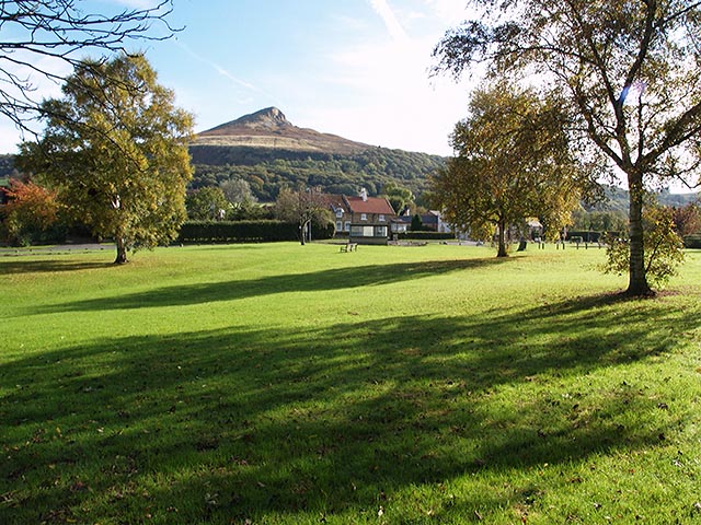
Newton under Roseberry is a picturesque village located in the North Yorkshire Moors National Park, in the northern part of England. Situated at the foot of Roseberry Topping, an iconic hill that offers breathtaking views of the surrounding countryside, this village attracts visitors with its natural beauty and tranquil atmosphere.

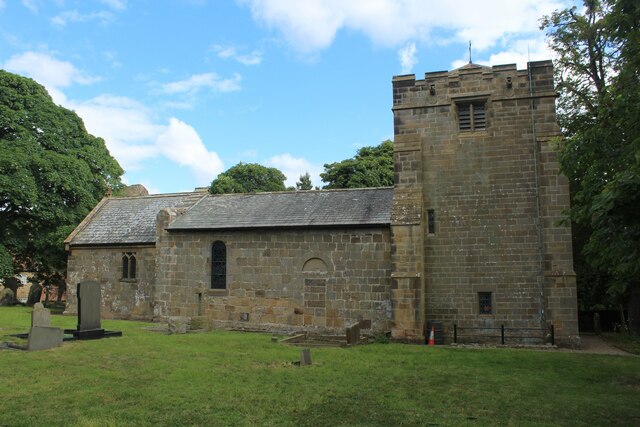
The village itself is small and quaint, with traditional stone-built houses and well-maintained gardens. It has a close-knit community, and residents take pride in preserving the village's heritage and charm. The local church, St. Oswald's, is a focal point of the community and dates back to the 12th century, featuring beautiful stained glass windows and impressive architecture.

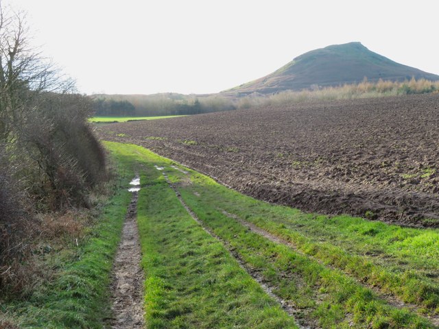
Nature lovers are drawn to Newton under Roseberry due to its proximity to the stunning North York Moors. The area offers a plethora of walking and hiking trails, allowing visitors to explore the diverse flora and fauna of the region. The highlight for many is the ascent of Roseberry Topping, a distinctive hill that stands at 1,049 feet and offers panoramic views of the North York Moors and the North Sea.

For those seeking cultural experiences, nearby towns such as Great Ayton and Guisborough offer historical landmarks and attractions. Great Ayton is particularly significant as it was the childhood home of Captain James Cook, the renowned explorer. Visitors can explore the Captain Cook Schoolroom Museum or take a stroll along the River Leven, which runs through the village.

In conclusion, Newton under Roseberry is a charming village nestled in the North Yorkshire Moors, providing visitors with a peaceful retreat and access to stunning natural landscapes.

If you have any feedback on the listing, please let us know in the comments section below.

Newton under Roseberry Images

Images are sourced within 2km of 54.511241/-1.121639 or Grid Reference NZ5613. Thanks to Geograph Open Source API. All images are credited.

Pinchinthorpe The Domesday Book records two manors in Pinchinthorpe.  The eastern half, centred on the modern Pinchinthorpe House (but not as far as the Pinchinthorpe Visitor Centre) and the western half comprising Pinchinthorpe Hall.

The photo shows almost the full extent of the western half. Bottom left, partially hidden by trees is Pinchinthorpe Hall. The farm on the right is High Farm. The two farms in the right distance are Spite Hall Farm and Low Farm, also part of the manor. It’s a long narrow manor, I am actually standing on the south-eastern tip.

The fields north of the A173 between the hall and High Farm contain lots of humps and bumps, the site of the medieval hamlet. The name itself, Pinchinthorpe, comes from the Norman family of ‘Pinchum’, the 12th-century holders of the manor.

The most interesting building through is Pinchinthorpe Hall, a 17th-century house which stands in moated grounds. The moated site and post medieval gardens are currently on Historic England’s Heritage at Risk register as “generally unsatisfactory with major localised problems”. The risk seems to be from gardening. The hall itself has recently been reopened as a hospitality venue.

For over 400 years the manor was in the hands of the Catholic Lee family. The family seems to have avoided holding positions of public office and this may have been because of their recusancy.

Main source: Dixon, Grace. “Two Ancient Townships – Studies of Pinchinthorpe and Hutton Lowcross”. 1991. ISBN 0 9507827 2 6.

For sources and references see my blog <span class="nowrap"><a title="http://www.fhithich.uk/?p=27311" rel="nofollow ugc noopener" href="http://www.fhithich.uk/?p=27311">Link</a><img style="margin-left:2px;" alt="External link" title="External link - shift click to open in new window" src="https://s1.geograph.org.uk/img/external.png" width="10" height="10"/></span>
Pinchinthorpe
The Domesday Book records two manors in Pinchinthorpe. The eastern half, centred on the modern Pinchinthorpe House (but not as far as the Pinchinthorpe Visitor Centre) and the western half comprising Pinchinthorpe Hall. The photo shows almost the full extent of the western half. Bottom left, partially hidden by trees is Pinchinthorpe Hall. The farm on the right is High Farm. The two farms in the right distance are Spite Hall Farm and Low Farm, also part of the manor. It’s a long narrow manor, I am actually standing on the south-eastern tip. The fields north of the A173 between the hall and High Farm contain lots of humps and bumps, the site of the medieval hamlet. The name itself, Pinchinthorpe, comes from the Norman family of ‘Pinchum’, the 12th-century holders of the manor. The most interesting building through is Pinchinthorpe Hall, a 17th-century house which stands in moated grounds. The moated site and post medieval gardens are currently on Historic England’s Heritage at Risk register as “generally unsatisfactory with major localised problems”. The risk seems to be from gardening. The hall itself has recently been reopened as a hospitality venue. For over 400 years the manor was in the hands of the Catholic Lee family. The family seems to have avoided holding positions of public office and this may have been because of their recusancy. Main source: Dixon, Grace. “Two Ancient Townships – Studies of Pinchinthorpe and Hutton Lowcross”. 1991. ISBN 0 9507827 2 6. For sources and references see my blog LinkExternal link
Cockle Scar When we look at a landscape photo it is very easy to be overwhelmed by the big picture and to miss the little features.

In centuries past, these features meant something, far more than now, and they had names.

It is these features that reveal interesting aspects of the landscape.

The distinctive change in steepness of the north-western face of Roseberry is clearly visible from the Cleveland Plain. This is a shot along the slope. Newton-under-Roseberry is the village extreme right.

And the edge on left is Cockle Scar, a name which I think most people climbing Roseberry will not be familiar with, anxious to achieve the summit.

Climb the wooden steps then the diagonal path through Newton Wood and when you get to the gate you will have crested Cockle Scar. It’s about at the 200m contour level.

The scar is formed from a seam of rock called the Staithes Sandstone Formation, which is more resistant to erosion than Redcar Mudstone Formation below it.

When the last ice age ice sheets swept along the Cleveland Plain from the north-west, the softer mudstone was more readily eroded leaving the edge.

Staithes sandstone is thinly bedded therefore not used much for building, and so not quarried.

Unlike the ‘cap’ of Roseberry which is a different sandstone, the Saltwick Sandstone Formation.

Cockle Scar is not named on the modern Tourist O.S. Maps. I haven’t come across many modern references.

The 2006 book “Roseberry Topping” is one, issued by the Great Ayton Community Archaeology Project.

Early last century, SirAlfred Pease (1857-1939) mentioned the feature in his memoires.

Is there a danger of it being lost?

For sources and references see my blog <span class="nowrap"><a title="http://www.fhithich.uk/?p=27429" rel="nofollow ugc noopener" href="http://www.fhithich.uk/?p=27429">Link</a><img style="margin-left:2px;" alt="External link" title="External link - shift click to open in new window" src="https://s1.geograph.org.uk/img/external.png" width="10" height="10"/></span>
Cockle Scar
When we look at a landscape photo it is very easy to be overwhelmed by the big picture and to miss the little features. In centuries past, these features meant something, far more than now, and they had names. It is these features that reveal interesting aspects of the landscape. The distinctive change in steepness of the north-western face of Roseberry is clearly visible from the Cleveland Plain. This is a shot along the slope. Newton-under-Roseberry is the village extreme right. And the edge on left is Cockle Scar, a name which I think most people climbing Roseberry will not be familiar with, anxious to achieve the summit. Climb the wooden steps then the diagonal path through Newton Wood and when you get to the gate you will have crested Cockle Scar. It’s about at the 200m contour level. The scar is formed from a seam of rock called the Staithes Sandstone Formation, which is more resistant to erosion than Redcar Mudstone Formation below it. When the last ice age ice sheets swept along the Cleveland Plain from the north-west, the softer mudstone was more readily eroded leaving the edge. Staithes sandstone is thinly bedded therefore not used much for building, and so not quarried. Unlike the ‘cap’ of Roseberry which is a different sandstone, the Saltwick Sandstone Formation. Cockle Scar is not named on the modern Tourist O.S. Maps. I haven’t come across many modern references. The 2006 book “Roseberry Topping” is one, issued by the Great Ayton Community Archaeology Project. Early last century, SirAlfred Pease (1857-1939) mentioned the feature in his memoires. Is there a danger of it being lost? For sources and references see my blog LinkExternal link
View to Roseberry Topping from the A171
Roseberry Topping Distinctive cone shaped summit of just over 1,000 feet above sea level, set slightly adrift of the Cleveland Hills proper.
Seen here from the village of Newton, at the western foot of the hill.
A spur from the Cleveland Way gives the National Trail walkers access to the top from the east.
Roseberry Topping
Distinctive cone shaped summit of just over 1,000 feet above sea level, set slightly adrift of the Cleveland Hills proper. Seen here from the village of Newton, at the western foot of the hill. A spur from the Cleveland Way gives the National Trail walkers access to the top from the east.
St. Oswald's Church, Newton under Roseberry Dedicated to the Northumbrian King Oswald.
Parts of the church are of Norman origin, but extensively re-constructed in Victorian times.
Grade II Listed Building
St. Oswald's Church, Newton under Roseberry
Dedicated to the Northumbrian King Oswald. Parts of the church are of Norman origin, but extensively re-constructed in Victorian times. Grade II Listed Building
The King's Head, Newton-under-Roseberry Hostelry on the main A173, near Great Ayton
The King's Head, Newton-under-Roseberry
Hostelry on the main A173, near Great Ayton
Anglo-Saxon carved stone — “a dragon attacking a quadruped” Built into the fabric of St. Oswald’s Church suggesting the existence of a much earlier church.
Anglo-Saxon carved stone — “a dragon attacking a quadruped”
Built into the fabric of St. Oswald’s Church suggesting the existence of a much earlier church.
Old Boundary Marker on the A173 between Pinchinthorpe Hall and Newton under Roseberry Parish Boundary Marker in the hedge on the east side of the A173 between Pinchinthorpe Hall and Newton under Roseberry. On the former boundary of Pinchinthorpe and Newton parishes but entirely in Guisborough parish since 1974. No inscription visible. Grade II Listed details <span class="nowrap"><a title="https://historicengland.org.uk/listing/the-list/list-entry/1329558" rel="nofollow ugc noopener" href="https://historicengland.org.uk/listing/the-list/list-entry/1329558">Link</a><img style="margin-left:2px;" alt="External link" title="External link - shift click to open in new window" src="https://s1.geograph.org.uk/img/external.png" width="10" height="10"/></span>.

Milestone Society National ID: YN_PINNEW01pb
Old Boundary Marker on the A173 between Pinchinthorpe Hall and Newton under Roseberry
Parish Boundary Marker in the hedge on the east side of the A173 between Pinchinthorpe Hall and Newton under Roseberry. On the former boundary of Pinchinthorpe and Newton parishes but entirely in Guisborough parish since 1974. No inscription visible. Grade II Listed details LinkExternal link. Milestone Society National ID: YN_PINNEW01pb
Marker Stone on way up Roseberry Topping
View from top of Roseberry Topping
Muddy field below Roseberry Topping A view taken during a very damp November with a view towards Roseberry Topping from the roadside car park.  The roads around Newton under Roseberry are double yellow lined, whilst even the side lanes in the village are resident parking only. This indicates the demand for parking in the area which is popular with walkers heading for Roseberry Topping. The local council has even installed parking ticket machines in the lay-by here.
Muddy field below Roseberry Topping
A view taken during a very damp November with a view towards Roseberry Topping from the roadside car park. The roads around Newton under Roseberry are double yellow lined, whilst even the side lanes in the village are resident parking only. This indicates the demand for parking in the area which is popular with walkers heading for Roseberry Topping. The local council has even installed parking ticket machines in the lay-by here.
Holiday cottages Bousdale Farm Most likely converted from old farm buildings.
Holiday cottages Bousdale Farm
Most likely converted from old farm buildings.
Path across Bousdale Hill Line of a bridleway heading towards Bousdale Farm.
Path across Bousdale Hill
Line of a bridleway heading towards Bousdale Farm.
Path towards Roseberry Common The path runs along the top edge of High Bousdale Wood with the familiar shape of Roseberry Topping in the distance.
Path towards Roseberry Common
The path runs along the top edge of High Bousdale Wood with the familiar shape of Roseberry Topping in the distance.
Some heavy going ahead Gate at a junction of two bridleways close by Hanging Stone Wood. After recent rains the path on the far side of the gate is across some very muddy land.
Some heavy going ahead
Gate at a junction of two bridleways close by Hanging Stone Wood. After recent rains the path on the far side of the gate is across some very muddy land.
Bridle Gill A short, steep sided valley on the western edge of the hills. It is unnamed on current maps, but the first edition 6" map of the 1850's indicates that this is Bridle Gill. The view extends as far as the industrial landscape of Teesside.
Bridle Gill
A short, steep sided valley on the western edge of the hills. It is unnamed on current maps, but the first edition 6" map of the 1850's indicates that this is Bridle Gill. The view extends as far as the industrial landscape of Teesside.
An optional extra on the Cleveland Way The steep path down towards the col between Newton Moor and Roseberry Topping forms an extra short but challenging diversion from the Cleveland Way. The option is to descend to the col, ascend Roseberry Topping and then reverse the route. Some may be content with the view from the main path.
An optional extra on the Cleveland Way
The steep path down towards the col between Newton Moor and Roseberry Topping forms an extra short but challenging diversion from the Cleveland Way. The option is to descend to the col, ascend Roseberry Topping and then reverse the route. Some may be content with the view from the main path.
Path to Newton under Roseberry Anyone ascending Roseberry Topping from Newton might find this the easiest way as it circles around the north side of the hill, leaving the short but steep ascent to the summit from the east side.
Path to Newton under Roseberry
Anyone ascending Roseberry Topping from Newton might find this the easiest way as it circles around the north side of the hill, leaving the short but steep ascent to the summit from the east side.
Show me another place!

Newton under Roseberry is located at Grid Ref: NZ5613 (Lat: 54.511241, Lng: -1.121639)

Division: North Riding

Unitary Authority: Redcar and Cleveland

Police Authority: Cleveland

What 3 Words

///breezy.sobbed.crypt. Near Great Ayton, North Yorkshire

Related Wikis

Newton under Roseberry

Newton under Roseberry is a village in the borough of Redcar and Cleveland and the ceremonial county of North Yorkshire, England. It is on the A173, between...

Roseberry Topping

Roseberry Topping is a distinctive hill in North Yorkshire, England. It is situated near Great Ayton and Newton under Roseberry. Its summit has a distinctive...

Langbaurgh Ridge

Langbaurgh Ridge (grid reference NZ560121) is an 8.0 hectare geological Site of Special Scientific Interest near the hamlet of Langbaurgh in North Yorkshire...

Cleveland, Yorkshire

Cleveland is a land of hills and dales from the River Tees to Vale of Pickering, England. The name means “cliff-land”. The area corresponds to the former...

Roseberry Mine

Roseberry Mine was an ironstone mine in the North Riding of Yorkshire, England, which operated between 1883 and 1924, with a break of 24 years. Both periods...

Langbaurgh, North Yorkshire

Langbaurgh is a hamlet in the civil parish of Great Ayton in North Yorkshire, England. The place gave its name to the Langbaurgh Wapentake.Langbaurgh Hall...

Roseberry Parkway railway station

Roseberry Parkway railway station (also known as Nunthorpe Parkway) is a proposed railway station which would be between Nunthorpe and Great Ayton railway...

Pinchinthorpe railway station

Pinchinthorpe railway station was a railway station on the Middlesbrough and Guisborough Railway (M&GR). It was opened on 25 February 1854 and closed in...

Nearby Amenities

Located within 500m of 54.511241,-1.121639
Post Box
Post Box Type: wall
Royal Cypher: VR
Royal Cypher Wikidata: Q33102356
Lat/Long: 54.5091817/-1.120134
Newton Under Roseberry
Place: village
Wikidata: Q7020502
Lat/Long: 54.5095007/-1.1204097
The data included in this document is from www.openstreetmap.org. The data is made available under ODbL.

Have you been to Newton under Roseberry?

Leave your review of Newton under Roseberry below (or comments, questions and feedback).