Newport-on-Tay

Settlement in Fife

Scotland

Newport-on-Tay

Trig Point Overlooking Tay Bridges Sitting 93 metres up and having excellent views, this trig pillar is unusual for not being located at the top of the hill, meaning that it must only have been used in conjunction with pillars on the other side of the water.
It was first brought into service in 1948 and goes by the name of Northfield, after the farm below. There is no mystery to the farm's name - further North lies the very wide River Tay.
The two mile long Tay Rail Bridge, which sits upstream from the road bridge, is shown in the picture.
Trig Point Overlooking Tay Bridges Credit: Ian Dodds

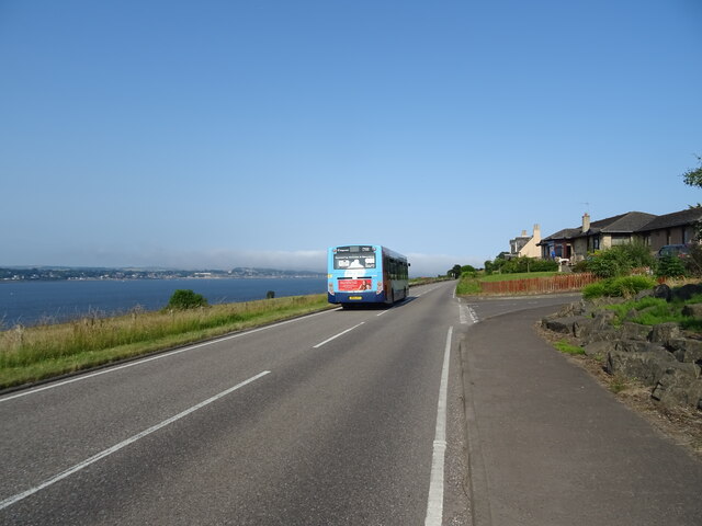
Newport-on-Tay is a small coastal town located in Fife, Scotland. Situated on the northern shores of the Firth of Tay, it is positioned directly opposite the city of Dundee, with the River Tay separating the two. The town has a population of around 3,000 residents.

Historically, Newport-on-Tay was a significant port for the ferry services that operated across the River Tay, connecting Fife with Dundee. However, with the construction of the Tay Road Bridge in 1966 and the subsequent opening of the Tay Rail Bridge in 1878, the town's importance as a transportation hub diminished.

Despite this, Newport-on-Tay retains its charm with stunning views across the river towards Dundee, as well as the picturesque slopes of the nearby Sidlaw Hills. The town offers a peaceful and friendly atmosphere, making it an attractive place to reside.

The town's amenities include a primary school, a library, a community center, and various shops and services. Residents and visitors can enjoy leisurely walks along the promenade or explore the nearby Tentsmuir Forest with its beautiful coastline and nature reserves.

Newport-on-Tay is also home to the Royal Tay Yacht Club, which provides sailing facilities and hosts various events throughout the year. Additionally, golf enthusiasts can take advantage of several golf courses in the surrounding area.

With its scenic location and proximity to Dundee, Newport-on-Tay offers a tranquil lifestyle while still providing easy access to the amenities and cultural attractions of a larger city.

If you have any feedback on the listing, please let us know in the comments section below.

Newport-on-Tay Images

Images are sourced within 2km of 56.440174/-2.9414156 or Grid Reference NO4227. Thanks to Geograph Open Source API. All images are credited.

Trig Point Overlooking Tay Bridges Sitting 93 metres up and having excellent views, this trig pillar is unusual for not being located at the top of the hill, meaning that it must only have been used in conjunction with pillars on the other side of the water.
It was first brought into service in 1948 and goes by the name of Northfield, after the farm below. There is no mystery to the farm's name - further North lies the very wide River Tay.
The two mile long Tay Rail Bridge, which sits upstream from the road bridge, is shown in the picture.
Trig Point Overlooking Tay Bridges
Sitting 93 metres up and having excellent views, this trig pillar is unusual for not being located at the top of the hill, meaning that it must only have been used in conjunction with pillars on the other side of the water. It was first brought into service in 1948 and goes by the name of Northfield, after the farm below. There is no mystery to the farm's name - further North lies the very wide River Tay. The two mile long Tay Rail Bridge, which sits upstream from the road bridge, is shown in the picture.
Lodge, Chesterhill
Lodge, Chesterhill
Grazing and woodland, Chesterhill
Minor road, Chesterhill Towards Inverdovat.
Minor road, Chesterhill
Towards Inverdovat.
Woodland near Inverdovat
Cottages, Inverdovat
Downhill towards the A92 Minor road from Inverdovat.
Downhill towards the A92
Minor road from Inverdovat.
Approaching Forgan Roundabout on the A92 Heading south.
Approaching Forgan Roundabout on the A92
Heading south.
Service station on the A92 near Forgan Roundabout
A92 towards Glenrothes Beware of falling rocks in the cutting.
Also beware of motorists telling cyclists that they have no right to be on their road.
A92 towards Glenrothes
Beware of falling rocks in the cutting. Also beware of motorists telling cyclists that they have no right to be on their road.
National Cycle Route 1 in the centre of the Tay Road Bridge Towards Dundee.
National Cycle Route 1 in the centre of the Tay Road Bridge
Towards Dundee.
National Cycle Route 1 in the centre of the Tay Road Bridge Downhill towards Dundee.
National Cycle Route 1 in the centre of the Tay Road Bridge
Downhill towards Dundee.
National Cycle Route 1 in the centre of the Tay Road Bridge Downhill towards Dundee.
National Cycle Route 1 in the centre of the Tay Road Bridge
Downhill towards Dundee.
National Cycle Route 1 in the centre of the Tay Road Bridge Downhill towards Dundee.
National Cycle Route 1 in the centre of the Tay Road Bridge
Downhill towards Dundee.
B946 towards Tayport
Benchmark on Kirk Street/Bridge Street, Newport on Tay Ordnance Survey benchmark, described on database at <span class="nowrap"><a title="https://www.bench-marks.org.uk/bm143012" rel="nofollow ugc noopener" href="https://www.bench-marks.org.uk/bm143012">Link</a><img style="margin-left:2px;" alt="External link" title="External link - shift click to open in new window" src="https://s1.geograph.org.uk/img/external.png" width="10" height="10"/></span>. See also <a href="https://www.geograph.org.uk/photo/6980756">NO4127 : Junction of Bridge Street and Kirk Street, Newport on Tay</a>.
Benchmark on Kirk Street/Bridge Street, Newport on Tay
Ordnance Survey benchmark, described on database at LinkExternal link. See also NO4127 : Junction of Bridge Street and Kirk Street, Newport on Tay.
Junction of Bridge Street and Kirk Street, Newport on Tay There is an Ordnance Survey benchmark on the wall to the right of the bin. See <a href="https://www.geograph.org.uk/photo/6980737">NO4127 : Benchmark on Kirk Street/Bridge Street, Newport on Tay</a>.
Junction of Bridge Street and Kirk Street, Newport on Tay
There is an Ordnance Survey benchmark on the wall to the right of the bin. See NO4127 : Benchmark on Kirk Street/Bridge Street, Newport on Tay.
Gate at Inverdovat There is an Ordnance Survey rivet benchmark on the bottom stone in the picture. See <a href="https://www.geograph.org.uk/photo/6778536">NO4227 : Rivet benchmark on wall near Inverdovat</a>.
Gate at Inverdovat
There is an Ordnance Survey rivet benchmark on the bottom stone in the picture. See NO4227 : Rivet benchmark on wall near Inverdovat.
Show me another place!

Newport-on-Tay is located at Grid Ref: NO4227 (Lat: 56.440174, Lng: -2.9414156)

Unitary Authority: Fife

Police Authority: Fife

What 3 Words

///pocket.magazine.sourcing. Near Newport-on-Tay, Fife

Nearby Locations

Newport-on-Tay

Related Wikis

Newport-on-Tay

Newport-on-Tay is a small town in the north-east of Fife in Scotland, acting as a commuter town for Dundee. The Fife Coastal Path passes through Newport...

Newport-on-Tay East railway station

Newport-on-Tay East railway station formerly served the town of Newport-on-Tay, Fife, Scotland. The station closed in 1969. == Tayport branch == Newport...

Newport-on-Tay West railway station

Newport-on-Tay West railway station served the town of Newport-on-Tay, Fife, Scotland, from 1879 to 1969 on the Newport Railway. == History == The station...

Woodhaven, Fife

Woodhaven used to be a small village between Newport-on-Tay and Wormit in Fife, Scotland. Due to expansion of these two villages over the years, it is...

Tay Road Bridge

The Tay Road Bridge (Scottish Gaelic: Drochaid-rathaid na Tatha) carries the A92 road across the Firth of Tay from Newport-on-Tay in Fife to Dundee in...

Forgan (Fife)

Forgan is a civil parish in the Scottish county of Fife. It extends 4 miles in length along the north coast of Fife and is at the southern mouth of the...

Radio Tay

Radio Tay is a group of two Independent Local Radio stations serving Tayside and northeast Fife in Scotland. Radio Tay is owned and operated by Bauer Radio...

RRS Discovery

The RRS Discovery is a barque-rigged auxiliary steamship built in Dundee, Scotland for Antarctic research. Launched in 1901, she was the last traditional...

Nearby Amenities

Located within 500m of 56.440174,-2.9414156
Mini Roundabout
Direction: clockwise
Lat/Long: 56.4401683/-2.9414089
Mini Roundabout
Direction: clockwise
Lat/Long: 56.4390319/-2.9421589
Newport-on-Tay
Is In: Fife,Scotland,UK
Name Sco: Newport on Tey
Place: town
Population: 7922
Wikidata: Q508190
Wikipedia: en:Newport-on-Tay
Lat/Long: 56.4397014/-2.9416726
Traffic Calming: table
Lat/Long: 56.4431949/-2.9379479
Scotmid
Addr City: Newport-on-Tay
Addr Housenumber: 48
Addr Postcode: DD6 8AD
Addr Street: High Street
Brand: Scotmid
Brand Wikidata: Q7435719
Brand Wikipedia: en:Scotmid
Opening Hours: Mo-Sa 06:00-22:00; Su 07:00-22:00
Operator: Cooperative
Shop: convenience
Lat/Long: 56.4399774/-2.941387
Pub
Brig O' Tay
Lat/Long: 56.4379555/-2.9433324
Post Box
Brand: Royal Mail
Brand Wikidata: Q638098
Collection Times: Mo-Fr 17:15; Sa 11:45
Operator: Royal Mail
Operator Wikidata: Q638098
Post Box Type: lamp
Ref: DD6 147
Royal Cypher: scottish_crown
Lat/Long: 56.4398141/-2.9418133
Historic: memorial
Memorial: war_memorial
Lat/Long: 56.4408622/-2.9411453
Parking
Parking: surface
Lat/Long: 56.4392304/-2.942534
Spar
Addr City: Newport-on-Tay
Addr Housenumber: 16
Addr Postcode: DD6 8AD
Addr Street: High Street
Atm: yes
Brand: Spar
Brand Wikidata: Q610492
Brand Wikipedia: en:Spar (retailer)
Opening Hours: Mo-Sa 06:30-22:00; Su 07:00-22:00
Shop: convenience
Lat/Long: 56.4394724/-2.941705
Cafe
Manna Coffee
Cuisine: coffee_shop
Lat/Long: 56.4402002/-2.940943
Cafe
Starr's
Lat/Long: 56.4397189/-2.9414971
Recycling
Lat/Long: 56.4396323/-2.940991
Post Box
Collection Times: Mo-Fr 09:00; Sa 07:00
Operator: Royal Mail
Post Box Mounting: stone_wall
Post Box Type: wall
Ref: DD6 123D
Royal Cypher: VR
Royal Cypher Wikidata: Q33102356
Source: survey
Lat/Long: 56.4432046/-2.9400002
Addr City: Tayport
Addr Housenumber: 10
Addr Street: Tay Street
Lat/Long: 56.4407537/-2.9408975
Addr City: Newport on Tay
Addr Housenumber: 52
Addr Street: Tay Street
Lat/Long: 56.4421811/-2.9404443
Addr City: Tayport
Addr Housenumber: 54
Addr Street: Tay Street
Lat/Long: 56.4422502/-2.9404243
Addr City: Tayport
Addr Housenumber: 66
Addr Street: Tay Street
Lat/Long: 56.4432795/-2.9398467
Addr City: Tayport
Addr Housenumber: 8
Addr Street: Tay Street
Lat/Long: 56.4406995/-2.9409199
Fast Food
The Silvery Tay
Cuisine: fish_and_chips
Lat/Long: 56.4400626/-2.941304
Fast Food
Wing Wah
Cuisine: chinese
Lat/Long: 56.4374471/-2.9443792
Atm
Lat/Long: 56.4400436/-2.9414078
Crossing
Crossing: uncontrolled
Crossing Ref: zebra
Lat/Long: 56.4400859/-2.9414645
Crossing
Crossing: uncontrolled
Crossing Ref: zebra
Lat/Long: 56.4401561/-2.941122
Bus Stop
Bench: yes
Shelter: yes
Lat/Long: 56.4420085/-2.9404993
Bus Stop
Bench: yes
Shelter: yes
Lat/Long: 56.4423516/-2.940587
Entrance: yes
Lat/Long: 56.4404976/-2.9403502
Man Made: flagpole
Lat/Long: 56.4396035/-2.9410772
Bus Stop
Naptan AtcoCode: 6500N0073
Naptan NaptanCode: 34343937
Lat/Long: 56.4393026/-2.9419248
Bus Stop
Bench: no
Bus: yes
Naptan AtcoCode: 6500N0518
Naptan NaptanCode: 34343939
Public Transport: platform
Shelter: no
Lat/Long: 56.4397925/-2.9417464
Post Office
Newport-on-Tay Post Office
Addr City: Newport-on-Tay
Addr Postcode: DD6 8DB
Brand: Post Office
Brand Wikidata: Q1783168
Ref Pol Id: 177334
Lat/Long: 56.4393995/-2.9416165
Post Box
Brand: Royal Mail
Brand Wikidata: Q638098
Collection Times: Mo-Fr 17:30; Sa 11:45
Operator: Royal Mail
Operator Wikidata: Q638098
Post Box Type: pillar
Ref: DD6 146
Royal Cypher: GVIR
Royal Cypher Wikidata: Q33102169
Lat/Long: 56.4401492/-2.9408278
Leisure: bandstand
Lat/Long: 56.441686/-2.9408842
Bench
Lat/Long: 56.4402841/-2.9413723
Bench
Lat/Long: 56.4416919/-2.9409808
Bus Stop
Naptan AtcoCode: 6500N0552
Naptan NaptanCode: 34358584
Lat/Long: 56.4400306/-2.9404576
Telephone
Booth: KX100
Covered: booth
Lat/Long: 56.4400928/-2.9411148
Bench
Backrest: yes
Lat/Long: 56.4433171/-2.9400362
Post Box
Collection Times: Mo-Fr 09:00; Sa 07:00
Operator: Royal Mail
Post Box Type: lamp
Ref: DD6 121D
Royal Cypher: scottish_crown
Lat/Long: 56.4394804/-2.9372167
Defibrillator
Emergency: defibrillator
Opening Hours: 24/7
Lat/Long: 56.4399128/-2.9417631
Entrance: yes
Lat/Long: 56.4399172/-2.9417855
Minick of Newport
Shop: butcher
Lat/Long: 56.4401851/-2.9408531
Bus Stop
Bench: yes
Naptan AtcoCode: 6500N0070
Naptan NaptanCode: 34343928
Shelter: yes
Lat/Long: 56.438762/-2.9427856
Bus Stop
Bus: yes
Public Transport: platform
Lat/Long: 56.4390289/-2.9382005
Bus Stop
Bus: yes
Public Transport: platform
Lat/Long: 56.4391593/-2.9381118
Doctors
Tayview Medical Practice
Healthcare: doctor
Lat/Long: 56.4379379/-2.9358044
Newport-on-Tay East
Historic Railway: station
Railway: site
Wikidata: Q7018725
Wikipedia: en:Newport-on-Tay East railway station
Lat/Long: 56.4407078/-2.9351431
Library
Newport Library
Opening Hours: Mo,Fr 10:00-17:00; Tu 10:00-14:00; Fr 10:00-17:00; Sa 10:00-13:00
Lat/Long: 56.4394671/-2.9403724
Post Box
Collection Times: Mo-Fr 09:00; Sa 07:00
Manufacturer: Carronade
Operator: Royal Mail
Post Box Mounting: pier
Post Box Type: lamp
Ref: DD6 145D
Royal Cypher: scottish_crown
Source: survey
Lat/Long: 56.4364546/-2.9448626
The data included in this document is from www.openstreetmap.org. The data is made available under ODbL.

Have you been to Newport-on-Tay?

Leave your review of Newport-on-Tay below (or comments, questions and feedback).