Berwick

Settlement in Gloucestershire

England

Berwick

Compton Greenfield (Glos) All Saints Church
Compton Greenfield (Glos) All Saints Church Credit: ChurchCrawler

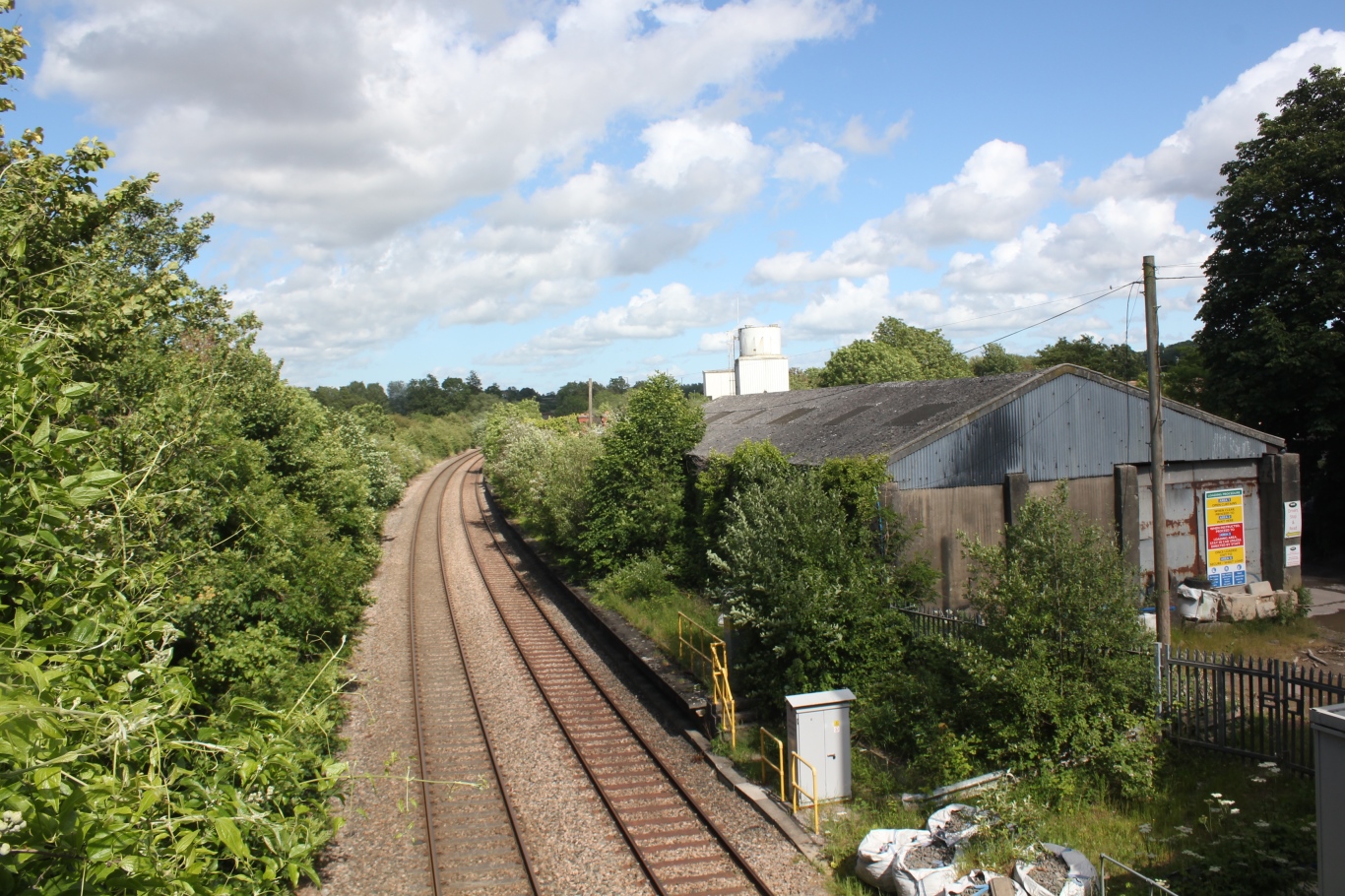
Berwick is a small village located in the county of Gloucestershire, in the southwestern part of England. Situated near the River Severn, it lies approximately 6 miles northwest of the town of Thornbury and 15 miles north of the city of Bristol. With a population of around 500 residents, Berwick retains a charming rural atmosphere.

The village is known for its picturesque surroundings, characterized by rolling green hills, meandering country lanes, and beautiful farmland. It is an ideal location for those seeking a peaceful and idyllic setting away from the hustle and bustle of city life. The community is tight-knit and welcoming, fostering a strong sense of belonging among its residents.

Berwick's history can be traced back to the Domesday Book of 1086, where it is mentioned as "Berewic." Over the centuries, the village has evolved, but it still retains some of its historic charm. The architecture reflects a mix of styles from different eras, with traditional stone cottages blending alongside more modern buildings.

Despite its small size, Berwick offers a range of amenities for its residents. These include a local pub, village hall, and a primary school, providing essential services and fostering a sense of community cohesion. The surrounding countryside also provides ample opportunities for outdoor activities such as walking, cycling, and horse riding.

Overall, Berwick is a tranquil and scenic village, offering a peaceful retreat for those seeking a rural lifestyle. Its rich history, picturesque landscapes, and strong community spirit make it an attractive place to live or visit in Gloucestershire.

If you have any feedback on the listing, please let us know in the comments section below.

Berwick Images

Images are sourced within 2km of 51.522977/-2.638642 or Grid Reference ST5580. Thanks to Geograph Open Source API. All images are credited.

Compton Greenfield (Glos) All Saints Church
Mercedes-Benz at Cribbs Just one of the many 'sheds' at Cribbs Causeway  shopping centre.
Mercedes-Benz at Cribbs
Just one of the many 'sheds' at Cribbs Causeway shopping centre.
The M49 near Avonmouth The storage tanks are in ST5481.
The M49 near Avonmouth
The storage tanks are in ST5481.
Wyck Beck Road, Henbury Behind the hedge beyond the roundabout is Clifton Rugby Ground. The row of trees on the horizon is the M5.
Wyck Beck Road, Henbury
Behind the hedge beyond the roundabout is Clifton Rugby Ground. The row of trees on the horizon is the M5.
Tree by Old Elizabethan's RFC Tree covered in mistletoe on the edge of the rugby pitch, by Severn Road.
Tree by Old Elizabethan's RFC
Tree covered in mistletoe on the edge of the rugby pitch, by Severn Road.
Church in Hallen The church is at the cross-roads in Hallen.
Church in Hallen
The church is at the cross-roads in Hallen.
Berwick
Berwick
Man Made Structure I don't know what this structure is that is marked on the OS Map running along the side of the road.
Man Made Structure
I don't know what this structure is that is marked on the OS Map running along the side of the road.
Man Made Embankment The end of the man-made embankment looking south-east. 
The map and the actual ground features seem slightly different as the footpath actually starts by the end of the structure. Another photo of the structure is <a href="https://www.geograph.org.uk/photo/118651">ST5580 : Man Made Structure</a> in the neighbouring grid square.
Man Made Embankment
The end of the man-made embankment looking south-east. The map and the actual ground features seem slightly different as the footpath actually starts by the end of the structure. Another photo of the structure is ST5580 : Man Made Structure in the neighbouring grid square.
End of the road This road used to go to Vimpenny's Common according to the 1940's OS Map, now the M49 blocks the way and Vimpenny's Common is no longer there. The M49 is on the horizon.
End of the road
This road used to go to Vimpenny's Common according to the 1940's OS Map, now the M49 blocks the way and Vimpenny's Common is no longer there. The M49 is on the horizon.
Road by Brook Farm
Road by Brook Farm
Compton Greenfield Junction leading into Compton Greenfield, looking north-west.
"Compton" is derived from the words 'combe' meaning valley, and 'ton' meaning settlement.
Compton Greenfield
Junction leading into Compton Greenfield, looking north-west. "Compton" is derived from the words 'combe' meaning valley, and 'ton' meaning settlement.
Steep winding road The road is narrow and climbs between the steep banks.
Steep winding road
The road is narrow and climbs between the steep banks.
Bridge under the M5 by Hollywood Tower The entrance to Hollywood Tower is on the left just before the bridge. On the other side of the bridge is the Cribbs Causeway Shopping Centre.
Bridge under the M5 by Hollywood Tower
The entrance to Hollywood Tower is on the left just before the bridge. On the other side of the bridge is the Cribbs Causeway Shopping Centre.
Gas works A view of all three gas containers from a field to the south.
Gas works
A view of all three gas containers from a field to the south.
Gas container A view of the sun striking the westernmost gas container with heavy rainclouds in the background.
Gas container
A view of the sun striking the westernmost gas container with heavy rainclouds in the background.
Gas works A view of all three gas containers from behind the Selvaco carbon plant.  The farm buildings in front of the containers are part of Minor farm.
Gas works
A view of all three gas containers from behind the Selvaco carbon plant. The farm buildings in front of the containers are part of Minor farm.
Electricity pylon This pylon is one of a long line carrying power from Seabank power station towards Bristol.
Electricity pylon
This pylon is one of a long line carrying power from Seabank power station towards Bristol.
Show me another place!

Berwick is located at Grid Ref: ST5580 (Lat: 51.522977, Lng: -2.638642)

Unitary Authority: South Gloucestershire

Police Authority: Avon and Somerset

What 3 Words

///noses.basket.modest. Near Severn Beach, Gloucestershire

Nearby Locations

Berwick Berwick Wood

Related Wikis

Berwick, Gloucestershire

Berwick is a hamlet in the South Gloucestershire district, in the English county of Gloucestershire. Nearby settlements include the city of Bristol and...

Hallen, Gloucestershire

Hallen is a village in South Gloucestershire, England, just north of the Bristol city boundary. It is southwest of Easter Compton, northeast of Avonmouth...

Cribbs F.C.

Cribbs Football Club is an English football club founded in 1958 and based at Cribbs Causeway, South Gloucestershire. They are currently members of Southern...

Hallen A.F.C.

Hallen Association Football Club is a non league football club based in Hallen, near Bristol, England. Affiliated to the Gloucestershire County FA, they...

Hallen Halt railway station

Hallen Halt railway station was a railway station in Hallen, Gloucestershire, England, on the Henbury Loop Line. The station is closed, and the line is...

Henbury railway station

Henbury railway station served the Bristol suburb of Henbury, England, from 1910 to 1965. The station was situated on the Henbury Loop Line of the Great...

Blaise High School

Blaise High School (formerly Henbury School) is an 11–18 mixed, secondary school and sixth form with academy status in Henbury, Bristol, England. It was...

Compton Greenfield

Compton Greenfield is a small hamlet of farms and spread out houses to the south west of Easter Compton, in South Gloucestershire. The parish church of...

Nearby Amenities

Located within 500m of 51.522977,-2.638642
Bus Stop
Berwick Farm
Naptan AtcoCode: 0170SGB20569
Naptan Bearing: S
Naptan CommonName: Berwick Farm
Naptan NaptanCode: sgladpa
Naptan Street: Berwick Lane
Naptan Verified: no
Source: naptan_import
Lat/Long: 51.5229564/-2.6401776
Bus Stop
Berwick Farm
Naptan AtcoCode: 0170SGB20570
Naptan Bearing: S
Naptan CommonName: Berwick Farm
Naptan NaptanCode: sgladpd
Naptan Street: Berwick Lane
Naptan Verified: no
Source: naptan_import
Lat/Long: 51.5229131/-2.6398599
Bus Stop
Sampsons Farm Cottages
Naptan AtcoCode: 0170SGB20571
Naptan Bearing: N
Naptan CommonName: Sampsons Farm Cottages
Naptan NaptanCode: sgladpm
Naptan Street: Berwick Lane
Naptan Verified: no
Source: naptan_import
Lat/Long: 51.5263028/-2.6378634
Bus Stop
Sampsons Farm Cottages
Naptan AtcoCode: 0170SGB20572
Naptan Bearing: S
Naptan CommonName: Sampsons Farm Cottages
Naptan NaptanCode: sgladpt
Naptan Street: Berwick Lane
Naptan Verified: no
Source: naptan_import
Lat/Long: 51.5262965/-2.6377594
Barrier: kissing_gate
Lat/Long: 51.5209091/-2.638022
Max Events
Sport: motor
Lat/Long: 51.5211135/-2.6337453
Communication Mobile Phone: yes
Man Made: mast
Tower Type: communication
Lat/Long: 51.5204835/-2.635853
Colour: yellow;black
Marker: aerial
Operator: GPSS
Utility: oil
Lat/Long: 51.5218127/-2.6450293
Colour: yellow;black
Marker: aerial
Operator: GPSS
Utility: oil
Lat/Long: 51.521758/-2.644997
Colour: yellow;black
Marker: aerial
Operator: GPSS
Utility: oil
Lat/Long: 51.5218991/-2.6448989
Colour: yellow;black
Marker: aerial
Operator: GPSS
Utility: oil
Lat/Long: 51.5218561/-2.6448651
Colour: yellow;black
Marker: aerial
Operator: GPSS
Utility: oil
Lat/Long: 51.5223357/-2.6441287
Colour: yellow;black
Marker: aerial
Operator: GPSS
Utility: oil
Lat/Long: 51.5223294/-2.6440881
Colour: yellow;black
Marker: aerial
Operator: GPSS
Utility: oil
Lat/Long: 51.5221575/-2.6448453
Colour: yellow;black
Marker: aerial
Operator: GPSS
Utility: oil
Lat/Long: 51.523385/-2.6422643
Colour: yellow;black
Marker: aerial
Operator: GPSS
Utility: oil
Lat/Long: 51.5233753/-2.6422312
Colour: yellow;black
Marker: aerial
Operator: GPSS
Utility: oil
Lat/Long: 51.5250596/-2.6420106
Colour: white
Marker: stile
Operator: GPSS
Utility: oil
Lat/Long: 51.5250487/-2.6420046
Colour: yellow;black
Marker: aerial
Operator: GPSS
Utility: oil
Lat/Long: 51.5227788/-2.6432788
Drinking Water
Access: customers
Bottle: yes
Lat/Long: 51.5211286/-2.6335237
Access: customers
Backrest: no
Covered: yes
Leisure: picnic_table
Lat/Long: 51.5210807/-2.6336744
Waste Basket
Access: customers
Lat/Long: 51.5211418/-2.633609
Access: customers
Backrest: no
Covered: yes
Leisure: picnic_table
Lat/Long: 51.5210513/-2.6336959
Access: customers
Backrest: no
Covered: no
Leisure: picnic_table
Lat/Long: 51.521166/-2.6336321
Access: customers
Backrest: no
Covered: no
Leisure: picnic_table
Lat/Long: 51.5211509/-2.6336623
Waste Basket
Access: customers
Lat/Long: 51.5211774/-2.6337213
Access: customers
Backrest: no
Covered: no
Leisure: picnic_table
Lat/Long: 51.5211824/-2.6336638
Access: customers
Backrest: no
Covered: no
Leisure: picnic_table
Lat/Long: 51.5211678/-2.6336868
Access: customers
Backrest: no
Covered: yes
Leisure: picnic_table
Lat/Long: 51.5210639/-2.6336603
Camera Mount: pole
Camera Type: fixed
Man Made: surveillance
Surveillance: outdoor
Lat/Long: 51.5213529/-2.6339481
Shop: coffee
Lat/Long: 51.5210762/-2.6335997
Access: customers
Backrest: no
Covered: yes
Leisure: picnic_table
Lat/Long: 51.52109/-2.6336399
Barrier: kissing_gate
Lat/Long: 51.5200107/-2.6369389
Power: pole
Lat/Long: 51.5203207/-2.6426304
Power: pole
Lat/Long: 51.520817/-2.6413946
Power: pole
Lat/Long: 51.5213229/-2.6401707
Power: pole
Lat/Long: 51.521636/-2.6394261
Power: pole
Lat/Long: 51.5223805/-2.6389691
Power: pole
Lat/Long: 51.5230451/-2.6385429
Power: pole
Lat/Long: 51.5237574/-2.6381155
Power: pole
Lat/Long: 51.5230828/-2.6384451
Power: pole
Lat/Long: 51.5235136/-2.6372324
Power: pole
Lat/Long: 51.5236925/-2.6367095
Power: pole
Lat/Long: 51.5238288/-2.6363432
Power: pole
Transformer: distribution
Lat/Long: 51.5241808/-2.6354129
Generator Source: solar
Power: generator
Lat/Long: 51.5212153/-2.6348734
Generator Source: solar
Power: generator
Lat/Long: 51.5211402/-2.6349901
Generator Source: solar
Power: generator
Lat/Long: 51.5210743/-2.6352395
The data included in this document is from www.openstreetmap.org. The data is made available under ODbL.

Have you been to Berwick?

Leave your review of Berwick below (or comments, questions and feedback).