Achtalean

Settlement in Inverness-shire

Scotland

Achtalean

Moorland North of Portree
Moorland North of Portree Credit: David Dixon

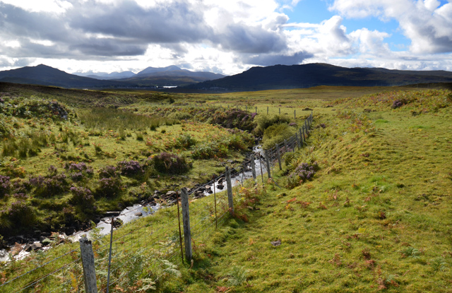
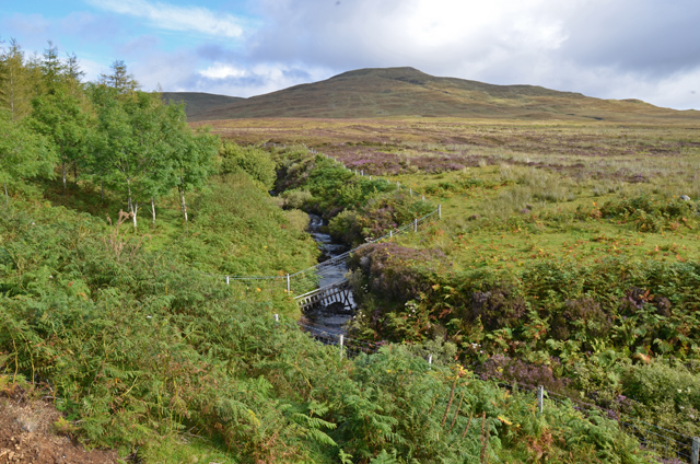
Achtalean is a small village located in the county of Inverness-shire in Scotland. Situated within the stunning Scottish Highlands, Achtalean is known for its picturesque scenery and tranquil atmosphere. The village is surrounded by lush green hills, rolling farmlands, and meandering rivers, making it a popular destination for those seeking a peaceful retreat in nature.

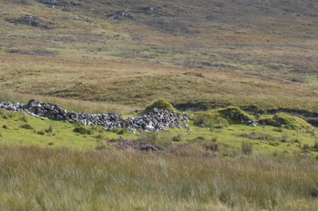
Achtalean is home to a tight-knit community of residents who take pride in their village's rich history and heritage. The architecture in Achtalean is a mix of traditional stone cottages and modern homes, showcasing a blend of old-world charm and contemporary design.

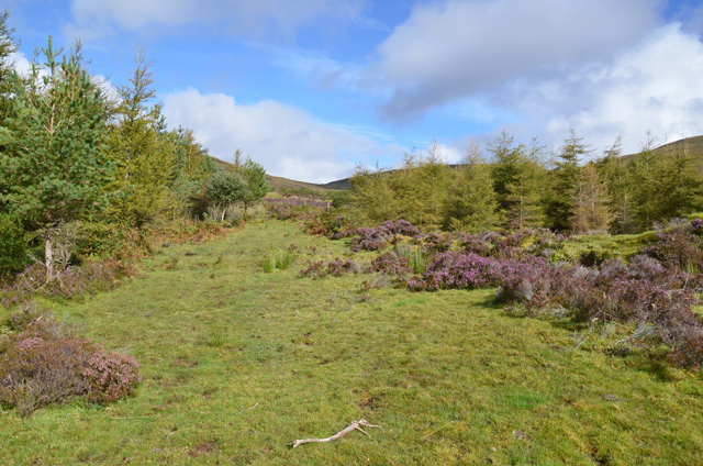
In terms of amenities, Achtalean offers a few local shops, cafes, and pubs for residents and visitors to enjoy. The village is also a great starting point for outdoor activities such as hiking, fishing, and birdwatching, with several scenic trails and nature reserves in the surrounding area.

Overall, Achtalean is a charming and idyllic village in the heart of the Scottish Highlands, offering a peaceful and scenic retreat for those looking to escape the hustle and bustle of modern life.

If you have any feedback on the listing, please let us know in the comments section below.

Achtalean Images

Images are sourced within 2km of 57.433633/-6.2170148 or Grid Reference NG4746. Thanks to Geograph Open Source API. All images are credited.

Moorland North of Portree
Moorland near Drumuie
A855 approaching Portree The A855 is approximately 33 miles long, encircling the Trotternish Peninsula at the north end of Skye. It is single-track for much of its length, undergoing fairly frequent repair as it is mostly built on top of a peat moor. Despite nominally being a coast road, the route is more often than not inland, with only glimpses of the sea available, particularly on the east coast of Trotternish. Despite this, however, it is a spectacular drive, and reveals some of Skye's finer features <span class="nowrap"><a title="https://www.sabre-roads.org.uk/wiki/index.php?title=A855" rel="nofollow ugc noopener" href="https://www.sabre-roads.org.uk/wiki/index.php?title=A855">Link</a><img style="margin-left:2px;" alt="External link" title="External link - shift click to open in new window" src="https://s1.geograph.org.uk/img/external.png" width="10" height="10"/></span> (SABRE).
A855 approaching Portree
The A855 is approximately 33 miles long, encircling the Trotternish Peninsula at the north end of Skye. It is single-track for much of its length, undergoing fairly frequent repair as it is mostly built on top of a peat moor. Despite nominally being a coast road, the route is more often than not inland, with only glimpses of the sea available, particularly on the east coast of Trotternish. Despite this, however, it is a spectacular drive, and reveals some of Skye's finer features LinkExternal link (SABRE).
A87, Sluggans The A87 runs 99 miles from Invergarry to Uig on the Isle of Skye <a href="https://www.geograph.org.uk/photo/7374675">NG3863 : End of the A87, Uig</a>.
<span class="nowrap"><a title="https://www.sabre-roads.org.uk/wiki/index.php?title=A87" rel="nofollow ugc noopener" href="https://www.sabre-roads.org.uk/wiki/index.php?title=A87">Link</a><img style="margin-left:2px;" alt="External link" title="External link - shift click to open in new window" src="https://s1.geograph.org.uk/img/external.png" width="10" height="10"/></span>
A87, Sluggans
The A87 runs 99 miles from Invergarry to Uig on the Isle of Skye NG3863 : End of the A87, Uig. LinkExternal link
A87 leaving Portree The A87 runs 99 miles from Invergarry to Uig on the Isle of Skye <a href="https://www.geograph.org.uk/photo/7374675">NG3863 : End of the A87, Uig</a>.
<span class="nowrap"><a title="https://www.sabre-roads.org.uk/wiki/index.php?title=A87" rel="nofollow ugc noopener" href="https://www.sabre-roads.org.uk/wiki/index.php?title=A87">Link</a><img style="margin-left:2px;" alt="External link" title="External link - shift click to open in new window" src="https://s1.geograph.org.uk/img/external.png" width="10" height="10"/></span>
A87 leaving Portree
The A87 runs 99 miles from Invergarry to Uig on the Isle of Skye NG3863 : End of the A87, Uig. LinkExternal link
A87, southbound The A87 runs 99 miles from Invergarry to Uig on the Isle of Skye <a href="https://www.geograph.org.uk/photo/7374675">NG3863 : End of the A87, Uig</a>.
<span class="nowrap"><a title="https://www.sabre-roads.org.uk/wiki/index.php?title=A87" rel="nofollow ugc noopener" href="https://www.sabre-roads.org.uk/wiki/index.php?title=A87">Link</a><img style="margin-left:2px;" alt="External link" title="External link - shift click to open in new window" src="https://s1.geograph.org.uk/img/external.png" width="10" height="10"/></span>
A87, southbound
The A87 runs 99 miles from Invergarry to Uig on the Isle of Skye NG3863 : End of the A87, Uig. LinkExternal link
Sharp bend, A87 The A87 runs 99 miles from Invergarry to Uig on the Isle of Skye <a href="https://www.geograph.org.uk/photo/7374675">NG3863 : End of the A87, Uig</a>.
<span class="nowrap"><a title="https://www.sabre-roads.org.uk/wiki/index.php?title=A87" rel="nofollow ugc noopener" href="https://www.sabre-roads.org.uk/wiki/index.php?title=A87">Link</a><img style="margin-left:2px;" alt="External link" title="External link - shift click to open in new window" src="https://s1.geograph.org.uk/img/external.png" width="10" height="10"/></span>
Sharp bend, A87
The A87 runs 99 miles from Invergarry to Uig on the Isle of Skye NG3863 : End of the A87, Uig. LinkExternal link
A87, southbound The A87 runs 99 miles from Invergarry to Uig on the Isle of Skye <a href="https://www.geograph.org.uk/photo/7374675">NG3863 : End of the A87, Uig</a>.
<span class="nowrap"><a title="https://www.sabre-roads.org.uk/wiki/index.php?title=A87" rel="nofollow ugc noopener" href="https://www.sabre-roads.org.uk/wiki/index.php?title=A87">Link</a><img style="margin-left:2px;" alt="External link" title="External link - shift click to open in new window" src="https://s1.geograph.org.uk/img/external.png" width="10" height="10"/></span>
A87, southbound
The A87 runs 99 miles from Invergarry to Uig on the Isle of Skye NG3863 : End of the A87, Uig. LinkExternal link
A87 entering Portree The A87 runs 99 miles from Invergarry to Uig on the Isle of Skye <a href="https://www.geograph.org.uk/photo/7374675">NG3863 : End of the A87, Uig</a>.
<span class="nowrap"><a title="https://www.sabre-roads.org.uk/wiki/index.php?title=A87" rel="nofollow ugc noopener" href="https://www.sabre-roads.org.uk/wiki/index.php?title=A87">Link</a><img style="margin-left:2px;" alt="External link" title="External link - shift click to open in new window" src="https://s1.geograph.org.uk/img/external.png" width="10" height="10"/></span>
A87 entering Portree
The A87 runs 99 miles from Invergarry to Uig on the Isle of Skye NG3863 : End of the A87, Uig. LinkExternal link
Co-op carpark, Portree
Scattered bushes in a barren brown field site
Eskidal Burn The burn is a headwater of the River Leasgeary, which reaches the sea in Portree Bay. Here it flows through land that was once cultivated by the inhabitants of the deserted settlement of Eskidal.
Eskidal Burn
The burn is a headwater of the River Leasgeary, which reaches the sea in Portree Bay. Here it flows through land that was once cultivated by the inhabitants of the deserted settlement of Eskidal.
Eskidal Burn The burn is a headwater of the River Leasgeary, which reaches the sea in Portree Bay. This a view upstream, with A'Chorra-Bheinn rising in the background.
Eskidal Burn
The burn is a headwater of the River Leasgeary, which reaches the sea in Portree Bay. This a view upstream, with A'Chorra-Bheinn rising in the background.
Ruins in Eskidal Some of the overgrown and tumbled ruins in the former settlement of Eskidal, north of Portree.
Ruins in Eskidal
Some of the overgrown and tumbled ruins in the former settlement of Eskidal, north of Portree.
Planted woodland in Eskidal A fenced area of woodland beside the Eskidal Burn. Much of it is coniferous, but it does include some native deciduous species around its edges.
Planted woodland in Eskidal
A fenced area of woodland beside the Eskidal Burn. Much of it is coniferous, but it does include some native deciduous species around its edges.
Show me another place!

Achtalean is located at Grid Ref: NG4746 (Lat: 57.433633, Lng: -6.2170148)

Unitary Authority: Highland

Police Authority: Highlands and Islands

What 3 Words

///received.menu.nags. Near Portree, Highland

Nearby Locations

Achtalean

Related Wikis

Achachork

Achachork (Scottish Gaelic: Achadh a' Choirce) is a small village in the Scottish council area of the Highland. It is lies on the A855 road to the north...

Bun-sgoil Ghàidhlig Phort Righ

Bun-sgoil Ghàidhlig Phort Righ is a Gaelic-medium primary school in Portree on Skye, Scotland. The school opened April 2018, becoming the third purpose...

Radio Skye

Radio Skye is a local radio station which broadcasts from Portree to the Isle of Skye, as well as the region of Lochalsh, Wester Ross on the Scottish mainland...

Pairc nan Laoch

Pairc nan Laoch is a shinty stadium in Portree, Isle of Skye, Scotland. It is home to Skye Camanachd. == History == Skye Camanachd originally played at...

Nearby Amenities

Located within 500m of 57.433633,-6.2170148
Power: pole
Lat/Long: 57.433131/-6.2171164
Power: pole
Lat/Long: 57.4369793/-6.2205065
Power: pole
Lat/Long: 57.4355139/-6.219627
Craigleadh
Place: isolated_dwelling
Lat/Long: 57.4312781/-6.2177677
Place: farm
Lat/Long: 57.4349338/-6.2113089
Power: pole
Lat/Long: 57.4329217/-6.2249431
Power: pole
Lat/Long: 57.4325218/-6.2243021
Power: pole
Lat/Long: 57.4319529/-6.223366
Power: pole
Lat/Long: 57.4314129/-6.2224513
Power: pole
Lat/Long: 57.4308931/-6.221585
Power: pole
Lat/Long: 57.4303401/-6.2207025
Power: pole
Lat/Long: 57.4297986/-6.2197933
Power: pole
Lat/Long: 57.4292528/-6.2188974
Power: pole
Lat/Long: 57.4370594/-6.2200159
Power: pole
Lat/Long: 57.4363462/-6.2195492
Power: pole
Lat/Long: 57.4362365/-6.2200695
Power: pole
Lat/Long: 57.4356201/-6.2190959
Power: pole
Lat/Long: 57.4343128/-6.2183462
Power: pole
Lat/Long: 57.4337288/-6.2171057
Power: pole
Lat/Long: 57.4319926/-6.2152778
Power: pole
Lat/Long: 57.4314526/-6.2147132
Power: pole
Lat/Long: 57.4314504/-6.215326
Power: pole
Lat/Long: 57.429738/-6.2129295
Power: pole
Lat/Long: 57.4308837/-6.2141056
Achtalean
Place: locality
Lat/Long: 57.4337343/-6.2191883
The data included in this document is from www.openstreetmap.org. The data is made available under ODbL.

Have you been to Achtalean?

Leave your review of Achtalean below (or comments, questions and feedback).