Nantglyn

Settlement in Denbighshire

Wales

Nantglyn

Church House, Nantglyn
Church House, Nantglyn Credit: Chris Andrews

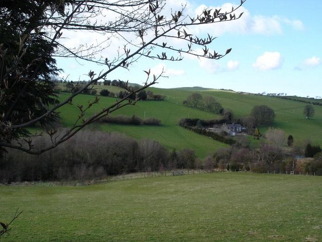
Nantglyn is a small village located in the county of Denbighshire in north-east Wales. Situated in the picturesque Vale of Clwyd, Nantglyn is surrounded by rolling hills and lush green countryside, offering stunning views and a tranquil atmosphere.

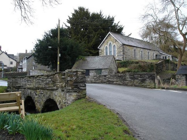
The village has a rich history dating back to the medieval period, with remnants of ancient settlements and landmarks still visible today. One of the notable features is the 13th-century St. James' Church, which stands proudly in the heart of the village. The church is known for its beautiful architecture and houses several historical artifacts.

Nantglyn is a close-knit community, with a population of around 500 residents. It offers a peaceful and idyllic lifestyle, making it an attractive destination for those seeking a rural retreat. The village has a friendly and welcoming atmosphere, with a strong sense of community spirit.

Although small in size, Nantglyn has a number of amenities to cater to its residents. These include a village hall, a primary school, and a local pub, which serves as a popular meeting place for residents and visitors alike. The surrounding area provides ample opportunities for outdoor activities such as hiking, cycling, and fishing.

Nantglyn's location also offers easy access to the nearby towns of Denbigh and Ruthin, where residents can find a wider range of services and amenities. Overall, Nantglyn is a charming village that combines natural beauty, historical significance, and a close community spirit.

If you have any feedback on the listing, please let us know in the comments section below.

Nantglyn Images

Images are sourced within 2km of 53.14611/-3.490038 or Grid Reference SJ0062. Thanks to Geograph Open Source API. All images are credited.

Church House, Nantglyn
St James' Church, Nantglyn
Bylchau Farmland to the northeast of Bylchau.
Bylchau
Farmland to the northeast of Bylchau.
Chapel at Waen, near Nantglyn Calvinist chapel, built 1811, at the side of the road going from Nantglyn to Bylchau.
Chapel at Waen, near Nantglyn
Calvinist chapel, built 1811, at the side of the road going from Nantglyn to Bylchau.
Steep hill A very steep hill to the west of Nantglyn (1 in 4).
Steep hill
A very steep hill to the west of Nantglyn (1 in 4).
Pen y Lôn Enw addas iawn! Ffordd hir, gul a serth i'w gyrraedd.
Translated means 'End of the road'. A very appropriate name as it is at the end of a long narrow steep road.
Pen y Lôn
Enw addas iawn! Ffordd hir, gul a serth i'w gyrraedd. Translated means 'End of the road'. A very appropriate name as it is at the end of a long narrow steep road.
Farmland near Saron Farmland in the Vale of Clwyd near Saron.
Farmland near Saron
Farmland in the Vale of Clwyd near Saron.
Minor road near Bryn Robin Looking southward.
Minor road near Bryn Robin
Looking southward.
Hedge lined minor road at Foel G'ap Looking south-westward.
Hedge lined minor road at Foel G'ap
Looking south-westward.
Tree lined minor road near Foel Gasyth Looking south-eastward.
Tree lined minor road near Foel Gasyth
Looking south-eastward.
Road (B4501) near to Cefn Looking north-westward in the direction of Denbigh.
Road (B4501) near to Cefn
Looking north-westward in the direction of Denbigh.
Vale of Tyn Y Twll Looking west into the valley at Tyn Y Twll, from the B5435/B4501 crossroads.
Vale of Tyn Y Twll
Looking west into the valley at Tyn Y Twll, from the B5435/B4501 crossroads.
Ty'n Y Fynnon Looking back down the valley across the farmland at Ty'n Y Ffynnon, with the farm buildings adjacent to the road in a fold of the valley.
Ty'n Y Fynnon
Looking back down the valley across the farmland at Ty'n Y Ffynnon, with the farm buildings adjacent to the road in a fold of the valley.
Felin Hen The brook which runs down from above Maes Cadarn and Plas Nantglyn passes under the road in a culvert beneath my feet, thence to the left and across the field behind the trees, eventually running past the farmhouse at Felin Hen which you see in centre shot.
Felin Hen
The brook which runs down from above Maes Cadarn and Plas Nantglyn passes under the road in a culvert beneath my feet, thence to the left and across the field behind the trees, eventually running past the farmhouse at Felin Hen which you see in centre shot.
Disused Chapel at Soar This picturesque little chapel at Soar stands by the brook which winds through the hamlet, and is deserving of more care and attention than its small community can afford. The chapel at Saron, a mile or so up the road, is used by several local communities, including Soar.
Disused Chapel at Soar
This picturesque little chapel at Soar stands by the brook which winds through the hamlet, and is deserving of more care and attention than its small community can afford. The chapel at Saron, a mile or so up the road, is used by several local communities, including Soar.
Afon Ystrad The river running through fields near to Groes
Afon Ystrad
The river running through fields near to Groes
Nantglyn fields
Nantglyn fields
Nantglyn Stone bridge running through the centre of the village
Nantglyn
Stone bridge running through the centre of the village
Show me another place!

Nantglyn is located at Grid Ref: SJ0062 (Lat: 53.14611, Lng: -3.490038)

Unitary Authority: Denbighshire

Police Authority: North Wales

What 3 Words

///pancakes.workforce.bearable. Near Henllan, Denbighshire

Related Wikis

Nantglyn

Nantglyn is a small village and community in Denbighshire, Wales. The population of the community taken at the 2011 census was 323. It is situated in a...

Cader

Cader is a village in Denbighshire, Wales.

Clwyd West (UK Parliament constituency)

Clwyd West (Welsh: Gorllewin Clwyd) is a constituency of the House of Commons of the Parliament of the United Kingdom (at Westminster). It elects one Member...

Clwyd West (Senedd constituency)

Clwyd West (Welsh: Gorllewin Clwyd) is a constituency of the Senedd. It elects one Member of the Senedd by the first past the post method of election....

Nearby Amenities

Located within 500m of 53.14611,-3.490038
Nantglyn
Created By: Potlatch 0.10f
Is In: Denbighshire,Cymru,Wales,UK
Place: village
Wikidata: Q13651875
Lat/Long: 53.146426/-3.4909008
Place: farm
Lat/Long: 53.1499615/-3.4921723
Place: farm
Lat/Long: 53.1487261/-3.4957128
Place: farm
Lat/Long: 53.1431534/-3.4883743
Power: pole
Lat/Long: 53.14731/-3.4902289
Material: wood
Power: pole
Lat/Long: 53.1468564/-3.4898347
Material: wood
Power: pole
Lat/Long: 53.1466086/-3.4898829
Power: pole
Lat/Long: 53.1464477/-3.4888825
Power: pole
Lat/Long: 53.1474886/-3.4908458
Power: pole
Lat/Long: 53.1476897/-3.4905079
Power: pole
Lat/Long: 53.1478714/-3.4902182
Power: pole
Lat/Long: 53.1483653/-3.4900573
Ford: yes
Lat/Long: 53.1451314/-3.4847113
Ford: yes
Lat/Long: 53.1455463/-3.4849157
Power: pole
Lat/Long: 53.1486963/-3.4910629
Power: pole
Lat/Long: 53.1490485/-3.4903816
Power: pole
Lat/Long: 53.14933/-3.4898264
Leisure: playground
Lat/Long: 53.1487843/-3.4890538
Post Box
Brand: Royal Mail
Brand Wikidata: Q638098
Collection Times: Mo-Fr 15:15; Sa 10:30
Operator: Royal Mail
Operator Wikidata: Q638098
Post Box Type: lamp
Ref: LL16 30
Royal Cypher: EIIR
Royal Cypher Wikidata: Q33102113
Lat/Long: 53.1470482/-3.4898604
Defibrillator
Defibrillator Location: On front wall of Church House
Emergency: defibrillator
Indoor: no
Lat/Long: 53.1469843/-3.4898433
War Memorial 1914-18
Historic: memorial
Memorial: war_memorial
Lat/Long: 53.146168/-3.4902281
Bus Stop
Bus: yes
Public Transport: platform
Shelter: yes
Lat/Long: 53.1476527/-3.4890145
Direction: 165
Generator Method: photovoltaic
Generator Output Electricity: yes
Generator Solar Modules: 22
Generator Source: solar
Generator Type: solar_photovoltaic_panel
Location: roof
Power: generator
Lat/Long: 53.1502209/-3.4910855
Direction: 145
Generator Method: photovoltaic
Generator Output Electricity: yes
Generator Solar Modules: 16
Generator Source: solar
Generator Type: solar_photovoltaic_panel
Location: roof
Power: generator
Lat/Long: 53.1498871/-3.4924655
Direction: 85
Generator Method: photovoltaic
Generator Output Electricity: yes
Generator Solar Modules: 4
Generator Source: solar
Generator Type: solar_photovoltaic_panel
Location: roof
Power: generator
Lat/Long: 53.1481194/-3.4894195
Direction: 175
Generator Method: photovoltaic
Generator Output Electricity: yes
Generator Solar Modules: 10
Generator Source: solar
Generator Type: solar_photovoltaic_panel
Location: roof
Power: generator
Lat/Long: 53.1480965/-3.4894795
The data included in this document is from www.openstreetmap.org. The data is made available under ODbL.

Have you been to Nantglyn?

Leave your review of Nantglyn below (or comments, questions and feedback).