Nantddu

Settlement in Brecknockshire

Wales

Nantddu

Milestone - Brecon 13 Not at position marked on OS map. Other end of lay-by.
Milestone - Brecon 13 Credit: Adrian Dust

Nantddu is a small village located in the historic county of Brecknockshire, Wales. Situated in the picturesque Brecon Beacons National Park, it offers stunning natural beauty and a tranquil setting for residents and visitors alike.

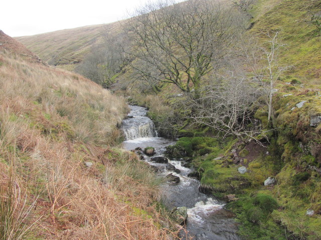
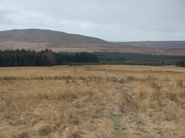
The village is nestled in the Usk Valley, surrounded by rolling hills and lush green countryside. It is located approximately 4 miles southeast of the market town of Brecon, the principal town of Brecknockshire. The River Usk flows nearby, adding to the scenic charm of the area.

Nantddu has a rich history, with evidence of human settlement dating back to prehistoric times. The village was traditionally a farming community, with agriculture playing a significant role in the local economy. Today, it retains its rural character, with a few working farms still operating in the vicinity.

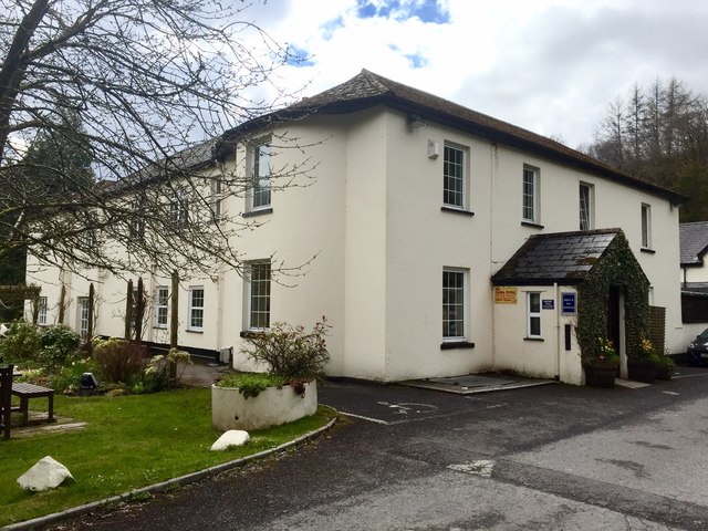
Despite its small size, Nantddu offers a range of amenities for residents, including a village hall and a pub. The community is close-knit and friendly, with a strong sense of community spirit.

For outdoor enthusiasts, Nantddu provides easy access to a variety of recreational activities. The Brecon Beacons National Park offers ample opportunities for hiking, cycling, and wildlife spotting. The nearby Brecon Beacons Mountain Range is a popular destination for climbers and mountaineers, with its highest peak, Pen y Fan, attracting many outdoor enthusiasts.

Overall, Nantddu is a charming village that offers a peaceful and idyllic setting amidst the natural beauty of the Brecon Beacons.

If you have any feedback on the listing, please let us know in the comments section below.

Nantddu Images

Images are sourced within 2km of 51.815652/-3.4520987 or Grid Reference SO0014. Thanks to Geograph Open Source API. All images are credited.

Milestone - Brecon 13 Not at position marked on OS map. Other end of lay-by.
Milestone - Brecon 13
Not at position marked on OS map. Other end of lay-by.
View up Cwm Taf towards Nant-Ddu Taken from the east side of the valley.
View up Cwm Taf towards Nant-Ddu
Taken from the east side of the valley.
View across Cwm Taf Garwnant Visitor Centre can be seen in the trees. The A470 runs along the valley floor.
View across Cwm Taf
Garwnant Visitor Centre can be seen in the trees. The A470 runs along the valley floor.
View up Cwm Llysiog Surprisingly remote cwm.
View up Cwm Llysiog
Surprisingly remote cwm.
Cwm Llysiog
Cwm Llysiog
Accommodation in Cwm Llysiog Not much of a roof in this shot but there were signs of recent use as a shelter (wood for burning, tarpaulin)?
Accommodation in Cwm Llysiog
Not much of a roof in this shot but there were signs of recent use as a shelter (wood for burning, tarpaulin)?
Confluence of Nant Wern-Ddu and Nant Llysiog
Nant Llysiog Not too hard going (after fording the stream) walking up Cwm Llysiog.
Nant Llysiog
Not too hard going (after fording the stream) walking up Cwm Llysiog.
View from Cefn Ynys-fawr View down to Llwyn-on Reservoir.
View from Cefn Ynys-fawr
View down to Llwyn-on Reservoir.
View west from Cefn Ynys-fawr A sometimes faint track heads towards the forestry.
View west from Cefn Ynys-fawr
A sometimes faint track heads towards the forestry.
Nant Ddu Lodge The Nant Ddu Lodge - a country hotel in the heart of the Brecon Beacons.
Nant Ddu Lodge
The Nant Ddu Lodge - a country hotel in the heart of the Brecon Beacons.
Nant Ddu The Nant Ddu, or Black Stream, flowing past Nant Ddu lodge.
Nant Ddu
The Nant Ddu, or Black Stream, flowing past Nant Ddu lodge.
Woodland footpath One of several footpaths around Garwnant Visitors Centre in the Brecon Beacons.
Woodland footpath
One of several footpaths around Garwnant Visitors Centre in the Brecon Beacons.
Falls on the Garw Nant The stream which gives its name to the forest and so to the nearby Natural Resources Wales visitor centre is seen here tumbling over a succession of small edges. These beds of sandstone are the Plateau Beds, the same Old Red Sandstone strata which form the summits of Pen y Fan and Corn Du but which here, a few miles further south, are down at an elevation just below 1000ft above sea level. A number of small falls can be enjoyed from the easy access trail leading away from the centre and car park.
Falls on the Garw Nant
The stream which gives its name to the forest and so to the nearby Natural Resources Wales visitor centre is seen here tumbling over a succession of small edges. These beds of sandstone are the Plateau Beds, the same Old Red Sandstone strata which form the summits of Pen y Fan and Corn Du but which here, a few miles further south, are down at an elevation just below 1000ft above sea level. A number of small falls can be enjoyed from the easy access trail leading away from the centre and car park.
Footbridge over Garw Nant The stream tumbles over several short drops near to the centre. Worth a visit after rain when the falls are more impressive.
Footbridge over Garw Nant
The stream tumbles over several short drops near to the centre. Worth a visit after rain when the falls are more impressive.
Car park, Garwnant Visitor Centre Situated in Coed Taf Fawr, a large area of forestry in the Brecon Beacons National Park.
The forest is in the care of Natural Resources Wales which has taken over the functions previously carried out by Forestry Commission Wales.
Car park, Garwnant Visitor Centre
Situated in Coed Taf Fawr, a large area of forestry in the Brecon Beacons National Park. The forest is in the care of Natural Resources Wales which has taken over the functions previously carried out by Forestry Commission Wales.
Pont ger Garwnant / Bridge near Garwnant Pont haearn yn rychwantu Afon Tâf Fawr hrt Canolfan Ymwelwyr Garwnant.

An iron bridge spanning the Tâf Fawr river near Garwnant (trans. rough stream) Visitor Centre.
Pont ger Garwnant / Bridge near Garwnant
Pont haearn yn rychwantu Afon Tâf Fawr hrt Canolfan Ymwelwyr Garwnant. An iron bridge spanning the Tâf Fawr river near Garwnant (trans. rough stream) Visitor Centre.
Cronfa Ddwr Llwyn-onn / Llwyn-onn Reservoir Cronfa Ddwr Llwyn-onn, un o dair cronfa a adeladwyd yng Nghwm Tâf i gyflenwi dwr i ddinas Caerdydd.  

Llwyn-onn (trans. ashgrove), one of three reservoirs constructed in Cwm Tâf to supply water to Cardiff.
Cronfa Ddwr Llwyn-onn / Llwyn-onn Reservoir
Cronfa Ddwr Llwyn-onn, un o dair cronfa a adeladwyd yng Nghwm Tâf i gyflenwi dwr i ddinas Caerdydd. Llwyn-onn (trans. ashgrove), one of three reservoirs constructed in Cwm Tâf to supply water to Cardiff.
Show me another place!

Nantddu is located at Grid Ref: SO0014 (Lat: 51.815652, Lng: -3.4520987)

Unitary Authority: Powys

Police Authority: Dyfed Powys

What 3 Words

///donates.awestruck.calibrate. Near Merthyr Tydfil

Related Wikis

Cantref Reservoir

Cantref Reservoir is the middle of the three reservoirs in the Taff Fawr valley in Wales. It was built by Cardiff Corporation Waterworks between 1886 and...

Llwyn-on Reservoir

Llwyn-on Reservoir (or Llwyn Onn Reservoir) is the largest and southernmost of the three reservoirs in the Taf Fawr valley in South Wales. Cardiff Corporation...

Cadair Fawr

Cadair Fawr is a hill in the northern corner of the county borough of Rhondda Cynon Taf, Wales. It lies within the Brecon Beacons National Park and Fforest...

Daren Fach

Daren Fach is a Site of Special Scientific Interest in Merthyr Tydfil, south Wales. == See also == List of Sites of Special Scientific Interest in Mid...

Have you been to Nantddu?

Leave your review of Nantddu below (or comments, questions and feedback).