Achosnich

Settlement in Argyllshire

Scotland

Achosnich

Yachts at anchor Within the hour they had upped anchor and sailed
Yachts at anchor Credit: Jim Smillie

The requested URL returned error: 429 Too Many Requests

If you have any feedback on the listing, please let us know in the comments section below.
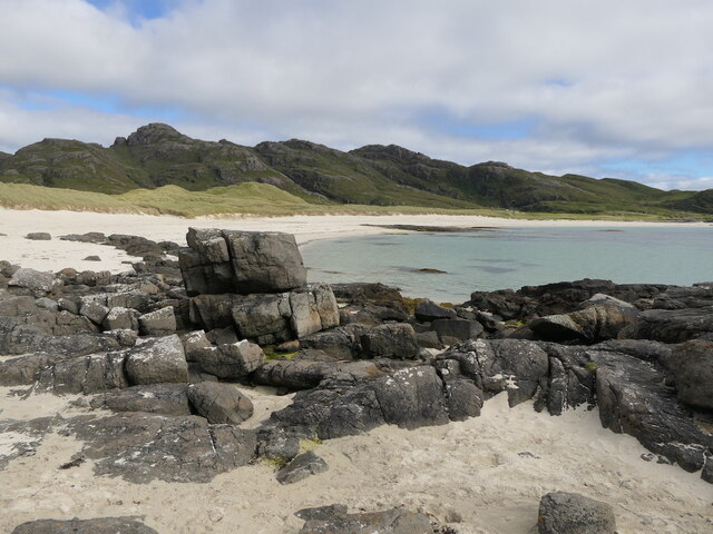
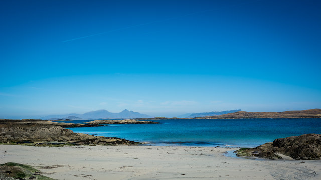
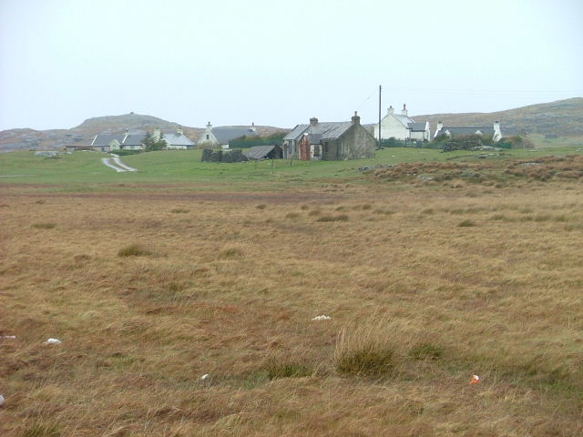
Achosnich Images

Images are sourced within 2km of 56.725582/-6.1788278 or Grid Reference NM4467. Thanks to Geograph Open Source API. All images are credited.

Yachts at anchor Within the hour they had upped anchor and sailed
Yachts at anchor
Within the hour they had upped anchor and sailed
Rock pools Mixture of rocks sand and water
Rock pools
Mixture of rocks sand and water
Sheltered bay with small boat Looking to Meall Sanna
Sheltered bay with small boat
Looking to Meall Sanna
Incoming tide Very small waves on a calm day
Incoming tide
Very small waves on a calm day
Meall Sanna Gabbro peak above the white sands of Sanna. Ardnamuchan Ring Complex.
Meall Sanna
Gabbro peak above the white sands of Sanna. Ardnamuchan Ring Complex.
Summit, Meall Sanna
Summit, Meall Sanna
Beach at Portuairk
Beach at Portuairk
Sonochan Hotel
Sonochan Hotel
Sonachan Hotel, Ardnamurchan In 2017, this hotel was closed.
Sonachan Hotel, Ardnamurchan
In 2017, this hotel was closed.
Track entrance near Achosnich
The road to Portuairk
Inlet at Portuairk
Inlet at Portuairk
Cycling on the beach at Sanna
Sheep by Loch Grigadale
Farm buildings at Grigadale
Boat by the Allt Grigadale
Tidal inlet, Sanna Bay There were some intricate patterns in the sand of the inlet stream. The crag on the left (gabbro I think) is sometimes used by climbers as a bouldering wall <span class="nowrap"><a title="https://www.ukclimbing.com/logbook/crag.php?id=16792" rel="nofollow ugc noopener" href="https://www.ukclimbing.com/logbook/crag.php?id=16792">Link</a><img style="margin-left:2px;" alt="External link" title="External link - shift click to open in new window" src="https://s1.geograph.org.uk/img/external.png" width="10" height="10"/></span> .
Tidal inlet, Sanna Bay
There were some intricate patterns in the sand of the inlet stream. The crag on the left (gabbro I think) is sometimes used by climbers as a bouldering wall LinkExternal link .
The B8007 near Sonachan Hotel Evening light on Beinn na Seilg.
The B8007 near Sonachan Hotel
Evening light on Beinn na Seilg.
Show me another place!

Achosnich is located at Grid Ref: NM4467 (Lat: 56.725582, Lng: -6.1788278)

Unitary Authority: Highland

Police Authority: Highlands and Islands

Also known as: Achadh Osnaich

What 3 Words

///grocers.polo.releasing. Near Kilchoan, Highland

Nearby Locations

Achadh Osnaich Achosnich

Related Wikis

Achosnich

Achosnich (Scottish Gaelic: Achadh Osnaich) is a crofting township in Ardnamurchan, Argyle within the Scottish council area of Highland. It is close to...

Portuairk

Portuairk (Scottish Gaelic: Port Uairce) is a crofting township, at the western end of the Ardnamurchan peninsula, Lochaber, Highland, Scotland. It is...

Achnaha

Achnaha (Scottish Gaelic: Achadh na h-Ă€tha) is a remote village in Ardnamurchan, Lochaber, in the Scottish council area of Highland. One of the local...

Sanna, Ardnamurchan

Sanna (Scottish Gaelic: Sanna) is a hamlet at the far western tip of the Scottish peninsula of Ardnamurchan, in Lochaber, Highland. It is one of the most...

Nearby Amenities

Located within 500m of 56.725582,-6.1788278
Achosnich
Name Gd: Achadh Osnaich
Place: hamlet
Wikidata: Q1885303
Wikipedia: en:Achosnich
Lat/Long: 56.7261342/-6.1793462
Ford: yes
Lat/Long: 56.7251284/-6.1739635
Power: pole
Lat/Long: 56.7293533/-6.1756843
Power: pole
Lat/Long: 56.7285462/-6.1758654
Power: pole
Lat/Long: 56.7281187/-6.1759257
Power: pole
Lat/Long: 56.7254295/-6.1728452
Power: pole
Lat/Long: 56.7259806/-6.1736056
Power: pole
Lat/Long: 56.7262543/-6.1739744
Power: pole
Lat/Long: 56.7277376/-6.176025
Power: pole
Lat/Long: 56.727224/-6.1753061
Power: pole
Lat/Long: 56.7268797/-6.1762825
Power: pole
Lat/Long: 56.7267326/-6.176717
Power: pole
Lat/Long: 56.7263867/-6.1776584
Power: pole
Lat/Long: 56.7262455/-6.1781198
Power: pole
Lat/Long: 56.7258371/-6.1792181
Power: pole
Lat/Long: 56.7255759/-6.1799638
Power: pole
Lat/Long: 56.7254199/-6.1804506
Power: pole
Lat/Long: 56.7252109/-6.1810246
Power: pole
Lat/Long: 56.72464/-6.1826876
Power: pole
Lat/Long: 56.7242044/-6.1839241
Power: pole
Lat/Long: 56.7237835/-6.1851391
Power: pole
Lat/Long: 56.7234921/-6.1859867
The data included in this document is from www.openstreetmap.org. The data is made available under ODbL.

Have you been to Achosnich?

Leave your review of Achosnich below (or comments, questions and feedback).