Moulsecomb

Settlement in Sussex

England

Moulsecomb

Montreal Road, Brighton Extinction Rebellion mural reflected on the side of a fossil-fuelled parked car, Montreal Road, Brighton
Montreal Road, Brighton Credit: screened out

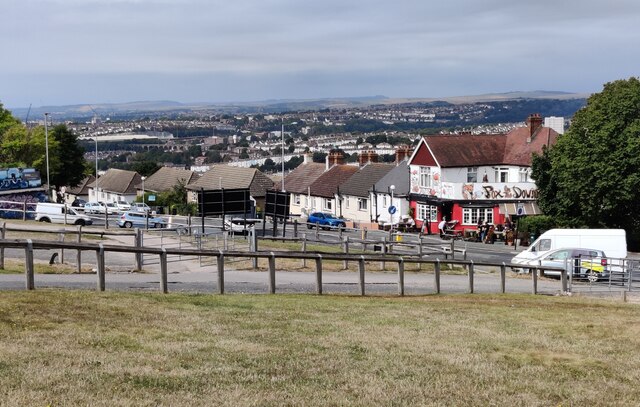
Moulsecomb is a small residential area located in the county of Sussex, England. Situated on the outskirts of the city of Brighton and Hove, Moulsecomb is primarily a suburb, offering a peaceful and family-friendly environment. It is bordered by the districts of Bevendean, Coldean, and Hollingdean, and is in close proximity to the South Downs National Park.

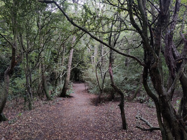
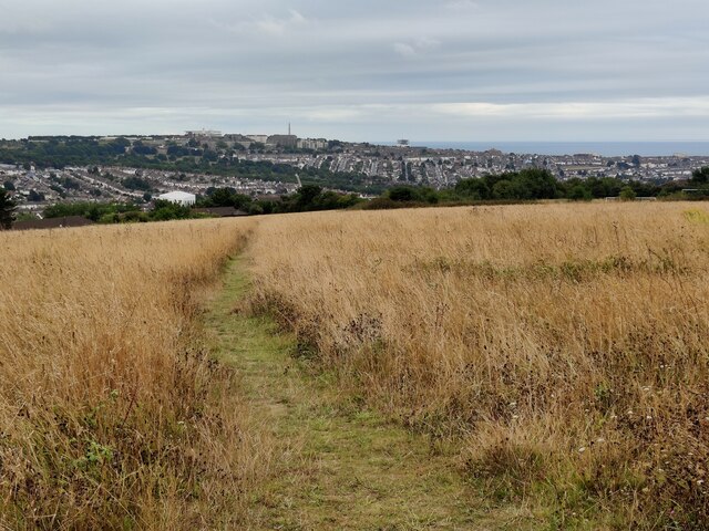
The area of Moulsecomb is known for its abundance of green spaces, making it an attractive place for nature lovers. Moulsecomb Park, located at the heart of the neighborhood, is a popular destination for residents, offering expansive lawns, playgrounds, and sports fields. The park is also home to the Moulsecoomb Forest Garden and Wildlife Project, which provides a valuable educational resource for the community.

Moulsecomb is well-served by public transportation, with regular bus services connecting it to the city center of Brighton and Hove. The area also benefits from its proximity to the University of Sussex and the University of Brighton, making it a convenient location for students and academics.

Amenities in Moulsecomb include a range of shops, restaurants, and cafes, providing residents with everyday conveniences. The neighborhood is also home to Moulsecomb Primary School, ensuring that families have access to quality education for their children.

Overall, Moulsecomb offers a tranquil and green environment, while still providing easy access to the vibrant city of Brighton and Hove. Its attractive location, amenities, and educational institutions make it an appealing place to reside.

If you have any feedback on the listing, please let us know in the comments section below.

Moulsecomb Images

Images are sourced within 2km of 50.838254/-0.1125068 or Grid Reference TQ3306. Thanks to Geograph Open Source API. All images are credited.

Montreal Road, Brighton Extinction Rebellion mural reflected on the side of a fossil-fuelled parked car, Montreal Road, Brighton
Montreal Road, Brighton
Extinction Rebellion mural reflected on the side of a fossil-fuelled parked car, Montreal Road, Brighton
Brighton viewed from near Whitehawk Hill
Round Hill Road in Brighton Round Hill is an inner city suburban area of Brighton. It was developed mostly in the late 19th century on an area of high land overlooking central Brighton, and contains a mix of privately owned and privately rented terraced housing.
Round Hill included a windmill, which stood on the 223-foot (68 m) hilltop until 1913.
Round Hill Road in Brighton
Round Hill is an inner city suburban area of Brighton. It was developed mostly in the late 19th century on an area of high land overlooking central Brighton, and contains a mix of privately owned and privately rented terraced housing. Round Hill included a windmill, which stood on the 223-foot (68 m) hilltop until 1913.
The Roundhill The Roundhill is a plant-based restaurant and pub on the corner of Round Hill Road and Ditchling Road, in the Round Hill area of Brighton.
Round Hill is an inner city suburban area of Brighton. It was developed mostly in the late 19th century on an area of high land overlooking central Brighton, and contains a mix of privately owned and privately rented terraced housing.
Round Hill included a windmill, which stood on the 223-foot (68 m) hilltop until 1913.
<a href="https://www.geograph.org.uk/photo/7270605">TQ3105 : The Roundhill at night</a>
The Roundhill
The Roundhill is a plant-based restaurant and pub on the corner of Round Hill Road and Ditchling Road, in the Round Hill area of Brighton. Round Hill is an inner city suburban area of Brighton. It was developed mostly in the late 19th century on an area of high land overlooking central Brighton, and contains a mix of privately owned and privately rented terraced housing. Round Hill included a windmill, which stood on the 223-foot (68 m) hilltop until 1913. TQ3105 : The Roundhill at night
The Jolly Brewer A public house along Ditchling Road on the corner of Florence Place, in the Round Hill area of Brighton. It dates back to as early as 1848. Tamplin's Brewery was a well known brewer in Victorian times, they acquired the property in 1874.
The Jolly Brewer
A public house along Ditchling Road on the corner of Florence Place, in the Round Hill area of Brighton. It dates back to as early as 1848. Tamplin's Brewery was a well known brewer in Victorian times, they acquired the property in 1874.
The Pub at Fiveways On the corner of Hollingbury Road and Ditchling Road in Brighton.
The Pub at Fiveways
On the corner of Hollingbury Road and Ditchling Road in Brighton.
Blakers Park in Brighton A small park in the Fiveways area of Brighton. The park was opened in 1894, and was given to the people of Brighton by Alderman Blaker.
Blakers Park in Brighton
A small park in the Fiveways area of Brighton. The park was opened in 1894, and was given to the people of Brighton by Alderman Blaker.
The Cleveland Arms A public house overlooking Blakers Park in the Fiveways and Preston Park area of Brighton. It is on the corner of Cleveland Road and Lucerne Road.
The Cleveland Arms
A public house overlooking Blakers Park in the Fiveways and Preston Park area of Brighton. It is on the corner of Cleveland Road and Lucerne Road.
Path to Roedale in Brighton
Hole 5 at Hollingbury Park Golf Course
Woodland next to the Hollingbury Park Golf Course
Grassland above Hollingdean
St Matthias Church at Fiveways, Brighton
Sign at the Pub at Fiveways At the junction of Hollingbury Road, Ditchling Road, Preston Drove and Stanford Avenue in Brighton.
Sign at the Pub at Fiveways
At the junction of Hollingbury Road, Ditchling Road, Preston Drove and Stanford Avenue in Brighton.
Petrol station along Ditchling Road, Brighton In the Round Hill area of Brighton.
Petrol station along Ditchling Road, Brighton
In the Round Hill area of Brighton.
Open House in Brighton A public house along Springfield Road, next to London Road Station.
Open House in Brighton
A public house along Springfield Road, next to London Road Station.
London Road viaduct in Brighton The brick railway viaduct carries the East Coastway Line between Brighton and London Road railway stations. It was built in the 1840s and is 67 feet (20 m) in height, and has a total length of 1,200 feet (370 m), across 27 spans. Approximately 10 million bricks were needed to build the viaduct.
London Road viaduct in Brighton
The brick railway viaduct carries the East Coastway Line between Brighton and London Road railway stations. It was built in the 1840s and is 67 feet (20 m) in height, and has a total length of 1,200 feet (370 m), across 27 spans. Approximately 10 million bricks were needed to build the viaduct.
Ditchling Rise in Round Hill, Brighton
Show me another place!

Moulsecomb is located at Grid Ref: TQ3306 (Lat: 50.838254, Lng: -0.1125068)

Unitary Authority: Brighton and Hove

Police Authority: Sussex

What 3 Words

///tides.stones.winner. Near Brighton, East Sussex

Nearby Locations

Moulsecomb Racehill Valley

Related Wikis

Bear Road, Brighton

The Bear Road area is a largely residential area in the east of Brighton, part of the English city of Brighton and Hove. Centred on the steep west–east...

Brighton Business School

The School of Business and Law is part of the University of Brighton. It offers undergraduate and postgraduate degrees. The school has approximately 500...

Preston Barracks

Preston Barracks was a military installation on Lewes Road, Brighton. All of the buildings on the site (except for the Crimean War Building) have been...

Brighton Electric

Brighton Electric is a music studio complex & Bar/Venue in Brighton, UK, founded in 2000. The main premises was built in 1897 as the Brighton Corporation...

Nearby Amenities

Located within 500m of 50.838254,-0.1125068
Traffic Calming: bump
Lat/Long: 50.8394858/-0.1158338
Traffic Calming: hump
Lat/Long: 50.8399569/-0.1153576
Leisure: playground
Lat/Long: 50.8374768/-0.112594
Give Way
Direction: forward
Lat/Long: 50.8387868/-0.107944
Give Way
Direction: backward
Lat/Long: 50.8386974/-0.1070484
Give Way
Direction: forward
Lat/Long: 50.8387667/-0.1065771
Traffic Calming: bump
Lat/Long: 50.8426558/-0.1114824
Traffic Calming: bump
Lat/Long: 50.8417835/-0.1087676
Traffic Calming: bump
Lat/Long: 50.8417794/-0.1109379
Bus Stop
Eastbourne Road
Bus: yes
Naptan AtcoCode: 149000007738
Operator: Brighton & Hove Buses
Public Transport: platform
Lat/Long: 50.8395859/-0.1124531
Turning Circle
Lat/Long: 50.8404178/-0.1088145
Traffic Calming: hump
Lat/Long: 50.8406872/-0.1153594
Traffic Calming: hump
Lat/Long: 50.8403331/-0.1149815
Traffic Calming: hump
Lat/Long: 50.8385946/-0.1171062
Traffic Calming: hump
Lat/Long: 50.8389962/-0.1164304
Traffic Calming: hump
Lat/Long: 50.8376818/-0.1155892
Direction: backward
Traffic Calming: choker
Lat/Long: 50.8394639/-0.1180318
Traffic Calming: hump
Lat/Long: 50.8401375/-0.1181585
Traffic Calming: hump
Lat/Long: 50.8387485/-0.1181596
Traffic Calming: hump
Lat/Long: 50.8392742/-0.1136048
Traffic Calming: hump
Lat/Long: 50.8377126/-0.1146059
Traffic Calming: hump
Lat/Long: 50.8379827/-0.1161826
Traffic Calming: hump
Lat/Long: 50.8399449/-0.1125316
Traffic Calming: hump
Lat/Long: 50.8383776/-0.119248
Traffic Calming: hump
Lat/Long: 50.8402829/-0.1134214
Traffic Calming: hump
Lat/Long: 50.8380977/-0.1151539
Traffic Calming: hump
Lat/Long: 50.8380231/-0.1189578
Traffic Calming: hump
Lat/Long: 50.840838/-0.1146366
Traffic Calming: hump
Lat/Long: 50.8405341/-0.1139627
Traffic Calming: hump
Lat/Long: 50.8400509/-0.1142644
Traffic Calming: hump
Lat/Long: 50.8399576/-0.1173759
Traffic Calming: hump
Lat/Long: 50.8377597/-0.1163712
Traffic Calming: hump
Lat/Long: 50.8402978/-0.116123
Traffic Calming: choker
Lat/Long: 50.8396757/-0.1190287
Traffic Calming: hump
Lat/Long: 50.837608/-0.1148653
Traffic Calming: hump
Lat/Long: 50.8393018/-0.117361
Traffic Calming: hump
Lat/Long: 50.8379331/-0.1180423
Traffic Calming: hump
Lat/Long: 50.8387111/-0.1141206
Traffic Calming: hump
Lat/Long: 50.8378495/-0.1172063
Traffic Calming: hump
Lat/Long: 50.8405884/-0.1174241
Traffic Calming: hump
Lat/Long: 50.8411664/-0.1168997
Traffic Calming: bump
Lat/Long: 50.8418299/-0.1097357
Traffic Calming: hump
Lat/Long: 50.8412905/-0.1101863
Traffic Calming: hump
Lat/Long: 50.8411488/-0.109525
Traffic Calming: hump
Lat/Long: 50.8413305/-0.107635
Traffic Calming: hump
Lat/Long: 50.8423705/-0.1116865
Traffic Calming: bump
Lat/Long: 50.8422605/-0.1107538
Post Box
Brand: Royal Mail
Brand Wikidata: Q638098
Brand Wikipedia: en:Royal Mail
Collection Plate: CP1D
Collection Times: Mo-Fr 09:00; Sa 07:00
Operator: Royal Mail
Operator Wikidata: Q638098
Post Box Type: pillar
Ref: BN2 195D
Royal Cypher: GR
Royal Cypher Wikidata: Q33102273
Lat/Long: 50.8379143/-0.1147663
Waste Basket
Waste: dog_excrement
Lat/Long: 50.835942/-0.1086362
Traffic Calming: hump
Lat/Long: 50.8411245/-0.1086663
Bus Stop
Eastbourne Road
Bus: yes
Naptan AtcoCode: 149000006739
Operator: Brighton & Hove Buses
Public Transport: platform
Lat/Long: 50.8399208/-0.1126059
Post Box
Brand: Royal Mail
Brand Wikidata: Q638098
Brand Wikipedia: en:Royal Mail
Operator: Royal Mail
Operator Wikidata: Q638098
Ref: BN2 364D
Lat/Long: 50.8390827/-0.108989
Post Box
Brand: Royal Mail
Brand Wikidata: Q638098
Operator: Royal Mail
Operator Wikidata: Q638098
Ref: BN2 196D
Lat/Long: 50.8381194/-0.1193053
Bus Stop
Manton Road
Bus: yes
Public Transport: platform
Lat/Long: 50.8418071/-0.1090358
Bus Stop
Manton Road
Bench: no
Bus: yes
Departures Board: timetable
Naptan AtcoCode: 149000006214
Naptan NaptanCode: brijmap
Operator: Brighton & Hove Buses
Public Transport: platform
Shelter: no
Lat/Long: 50.841102/-0.1094235
Woodvale North Chapel
Building: chapel
Lat/Long: 50.8349722/-0.1146912
Woodvale South Chapel
Building: chapel
Lat/Long: 50.8347944/-0.1148074
Traffic Calming: hump
Lat/Long: 50.8397725/-0.1165739
Street Lamp
Height: 10
Lamp Type: led
Lat/Long: 50.8415443/-0.1097652
Street Lamp
Lamp Type: led
Lat/Long: 50.841802/-0.1097875
Street Lamp
Lamp Type: led
Ref: 40
Lat/Long: 50.8416949/-0.110931
Street Lamp
Lamp Type: led
Lat/Long: 50.8421395/-0.1105816
Street Lamp
Lamp Type: led
Note: 42
Ref: 42
Lat/Long: 50.8421374/-0.1113038
Street Lamp
Lamp Type: led
Ref: 45
Lat/Long: 50.8426678/-0.1122389
Leisure: garden
Lat/Long: 50.8403852/-0.1100905
Barrier: bollard
Bollard: fixed
Height: 0.8
Material: plastic
Lat/Long: 50.8427017/-0.1114568
Barrier: bollard
Bollard: fixed
Height: 0.8
Material: plastic
Lat/Long: 50.8426887/-0.1114723
Barrier: bollard
Bollard: fixed
Height: 0.8
Material: plastic
Lat/Long: 50.8426576/-0.1115119
Barrier: bollard
Bollard: fixed
Height: 0.8
Material: plastic
Lat/Long: 50.8426413/-0.1114855
Traffic Sign: yes
Lat/Long: 50.842561/-0.1113647
Man Made: utility_pole
Material: wood
Operator: BT
Lat/Long: 50.8426405/-0.1113489
Street Lamp
Lamp Type: led
Lat/Long: 50.8425309/-0.1111398
Colour: green
Man Made: street_cabinet
Operator: BT
Street Cabinet: telecom
Lat/Long: 50.8424657/-0.1112321
Street Lamp
Lamp Type: led
Lat/Long: 50.8423564/-0.1108273
Barrier: bollard
Bollard: fixed
Height: 0.8
Material: plastic
Lat/Long: 50.8422915/-0.1107411
Barrier: bollard
Bollard: fixed
Colour: black
Height: 0.8
Material: plastic
Lat/Long: 50.8422774/-0.1107566
Barrier: bollard
Bollard: fixed
Colour: black
Height: 0.8
Material: plastic
Lat/Long: 50.8422488/-0.1107992
Barrier: bollard
Bollard: fixed
Colour: black
Height: 0.8
Material: plastic
Lat/Long: 50.8422314/-0.1107629
Man Made: utility_pole
Material: wood
Operator: BT
Lat/Long: 50.8421565/-0.1104088
Street Lamp
Lamp Type: led
Lat/Long: 50.8420541/-0.1101927
Man Made: manhole
Manhole: telecom
Operator: BT
Lat/Long: 50.8419082/-0.1101399
Man Made: manhole
Manhole: telecom
Operator: BT
Lat/Long: 50.8418423/-0.1100052
Colour: green
Man Made: street_cabinet
Operator: Virgin Media
Street Cabinet: cable_tv
Lat/Long: 50.8418242/-0.1100103
Man Made: manhole
Manhole: telecom
Operator: BT
Lat/Long: 50.8418647/-0.1099926
Street Lamp
Lat/Long: 50.8417427/-0.1093149
Street Lamp
Lamp Type: led1
Lat/Long: 50.8417644/-0.1087588
Street Lamp
Lamp Type: led
Lat/Long: 50.8418474/-0.1082944
Waste Basket
Waste: dog_excrement
Lat/Long: 50.8414297/-0.1075154
Barrier: bollard
Colour: black
Height: 0.8
Material: plastic
Lat/Long: 50.841156/-0.1086914
Street Lamp
Lat/Long: 50.8411682/-0.1085544
Barrier: bollard
Bollard: fixed
Height: 0.8
Material: plastic
Lat/Long: 50.8411578/-0.108645
Barrier: bollard
Bollard: fixed
Colour: black
Material: plastic
Width: 0.2
Lat/Long: 50.8411209/-0.1086413
Leisure: garden
Lat/Long: 50.8379987/-0.1092206
Barrier: bollard
Lat/Long: 50.8413647/-0.1076339
Barrier: bollard
Lat/Long: 50.8413495/-0.1076763
Barrier: bollard
Lat/Long: 50.8413309/-0.1076088
Barrier: bollard
Lat/Long: 50.8413059/-0.1075837
Waste Basket
Lat/Long: 50.8411153/-0.1096249
Street Lamp
Lamp Type: led
Lat/Long: 50.8412721/-0.1076225
Crossing
Lat/Long: 50.8413619/-0.1139819
Crossing
Lat/Long: 50.8415703/-0.1141836
Crossing
Lat/Long: 50.8419144/-0.1139759
Crossing
Lat/Long: 50.841932/-0.1133041
Crossing
Lat/Long: 50.841568/-0.1126931
Crossing
Lat/Long: 50.8417586/-0.1142359
Turning Loop
Lat/Long: 50.8396444/-0.1118716
Crossing
Lat/Long: 50.841988/-0.1136355
Crossing
Lat/Long: 50.8419256/-0.1133074
Crossing
Lat/Long: 50.8417018/-0.1128722
Crossing
Lat/Long: 50.841909/-0.1139681
Grit Bin
Lat/Long: 50.8402252/-0.1113021
Man Made: manhole
Manhole: drain
Lat/Long: 50.8402227/-0.1113445
Man Made: street_cabinet
Lat/Long: 50.8419884/-0.1135246
Street Lamp
Lat/Long: 50.8417344/-0.1129008
Street Lamp
Lat/Long: 50.8414927/-0.112567
Street Lamp
Lat/Long: 50.8412352/-0.1122166
Street Lamp
Lat/Long: 50.8405316/-0.1115172
Street Lamp
Lat/Long: 50.8404356/-0.1118019
Crossing
Lat/Long: 50.840635/-0.112266
Crossing
Lat/Long: 50.8406515/-0.1123048
Natural: shrub
Lat/Long: 50.8407916/-0.1125421
Natural: shrub
Lat/Long: 50.8407866/-0.1125326
Crossing
Lat/Long: 50.841163/-0.1135049
Crossing
Lat/Long: 50.8408194/-0.1127026
Crossing
Lat/Long: 50.8408033/-0.112663
Crossing
Lat/Long: 50.8409297/-0.1129624
Crossing
Lat/Long: 50.8415726/-0.1141589
Natural: shrub
Lat/Long: 50.8416133/-0.1143517
Natural: shrub
Lat/Long: 50.8415605/-0.114528
Natural: shrub
Lat/Long: 50.8415448/-0.1145355
Grit Bin
Lat/Long: 50.8416609/-0.1143037
Crossing
Lat/Long: 50.8405558/-0.1123186
Crossing
Lat/Long: 50.8402662/-0.1116458
Crossing
Lat/Long: 50.8415192/-0.1142949
Crossing
Lat/Long: 50.8417047/-0.1143124
Crossing
Lat/Long: 50.8415475/-0.1149097
Crossing
Lat/Long: 50.8415255/-0.1149381
Crossing
Lat/Long: 50.8413465/-0.1141545
Crossing
Lat/Long: 50.8413283/-0.1141258
Crossing
Lat/Long: 50.8412181/-0.1138841
Crossing
Lat/Long: 50.8413816/-0.1149614
Crossing
Lat/Long: 50.8413762/-0.1149217
Crossing
Lat/Long: 50.8398603/-0.1117578
Crossing
Lat/Long: 50.8409237/-0.1146869
Natural: shrub
Lat/Long: 50.8408829/-0.1159818
Natural: shrub
Lat/Long: 50.8410642/-0.1158557
Natural: shrub
Lat/Long: 50.8411012/-0.1158243
Natural: shrub
Lat/Long: 50.8411364/-0.1157915
Natural: shrub
Lat/Long: 50.841132/-0.1157653
Natural: shrub
Lat/Long: 50.8410856/-0.1157911
Crossing
Lat/Long: 50.8410056/-0.1148671
Grit Bin
Lat/Long: 50.8409374/-0.1150019
Fire Hydrant
Emergency: fire_hydrant
Water Source: main
Lat/Long: 50.8413835/-0.1151267
Street Lamp
Lamp Type: led
Ref: 02
Lat/Long: 50.8395339/-0.1081572
Barrier: bollard
Bollard: fixed
Material: wood
Lat/Long: 50.8395098/-0.1081775
Barrier: bollard
Bollard: fixed
Material: wood
Lat/Long: 50.839503/-0.1081727
Street Lamp
Lamp Type: led
Ref: 01
Lat/Long: 50.8396819/-0.1070013
Barrier: debris
Lat/Long: 50.8403615/-0.1127743
Fire Hydrant
Emergency: fire_hydrant
Water Source: main
Lat/Long: 50.8409838/-0.1118006
Crossing
Lat/Long: 50.8366834/-0.1115769
Street Lamp
Height: 18
Lamp Mount: straight_mast
Lamp Type: electric
Lat/Long: 50.8363713/-0.1092549
Street Lamp
Height: 18
Lamp Mount: straight_mast
Lamp Type: electric
Lat/Long: 50.8363164/-0.108723
Street Lamp
Height: 18
Lamp Mount: straight_mast
Lamp Type: electric
Lat/Long: 50.8362707/-0.1082565
Street Lamp
Height: 18
Lamp Mount: straight_mast
Lamp Type: electric
Lat/Long: 50.8361708/-0.1072255
Street Lamp
Height: 18
Lamp Mount: straight_mast
Lamp Type: electric
Lat/Long: 50.8361243/-0.1067189
Street Lamp
Height: 18
Lamp Mount: straight_mast
Lamp Type: electric
Lat/Long: 50.8360768/-0.1062725
House: terraced
Lat/Long: 50.8405757/-0.1171567
Traffic Calming: choker
Lat/Long: 50.8387529/-0.1078296
Traffic Calming: choker
Lat/Long: 50.8386925/-0.1071666
Traffic Calming: hump
Lat/Long: 50.8405203/-0.1184987
Street Lamp
Lamp Mount: bent_mast
Lamp Type: electric
Ref: 3
Lat/Long: 50.8408204/-0.1079576
Height: 9
Man Made: utility_pole
Material: wood
Operator: BT
Ref: 1377
Utility: telecom
Lat/Long: 50.8408234/-0.1079147
Historic: monument
Lat/Long: 50.8369617/-0.1105037
Historic: monument
Lat/Long: 50.8375486/-0.1094137
Noexit: yes
Lat/Long: 50.8378741/-0.1076672
Bench
Lat/Long: 50.8356786/-0.1109315
Bench
Lat/Long: 50.8357173/-0.110901
Bench
Lat/Long: 50.8357427/-0.1108735
Barrier: bollard
Bollard: fixed
Lat/Long: 50.8423529/-0.1116969
Barrier: bollard
Bollard: fixed
Lat/Long: 50.8423844/-0.1116476
Barrier: bollard
Bollard: fixed
Lat/Long: 50.8424121/-0.1116868
Street Lamp
Lamp Mount: straight_mast
Lamp Type: electric
Ref: 44
Lat/Long: 50.8424871/-0.11194
Height: 9
Man Made: utility_pole
Material: wood
Operator: BT
Utility: telecom
Lat/Long: 50.8423304/-0.1115558
Street Lamp
Lamp Mount: straight_mast
Lamp Type: electric
Ref: 43
Lat/Long: 50.842279/-0.1116459
Street Lamp
Lamp Mount: straight_mast
Lamp Type: electric
Ref: 41
Lat/Long: 50.8419045/-0.1111835
Street Lamp
Lamp Mount: straight_mast
Lamp Type: electric
Lat/Long: 50.8416942/-0.1109352
Street Lamp
Lamp Mount: straight_mast
Lamp Type: electric
Note: 39
Lat/Long: 50.8414501/-0.1106592
Traffic Calming: hump
Lat/Long: 50.8395673/-0.1147866
Traffic Calming: hump
Lat/Long: 50.8392563/-0.1143412
Traffic Calming: bump
Lat/Long: 50.8390644/-0.1193657
Traffic Calming: table
Lat/Long: 50.8397868/-0.1191504
Give Way
Direction: backward
Lat/Long: 50.839407/-0.1177865
Addr Country: GB
Building: house
Building Levels: 2
Building Material: brick
Height: 10
House: terraced
Roof Material: roof_tiles
Roof Orientation: across
Roof Shape: gabled
Lat/Long: 50.8382072/-0.1128262
Man Made: antenna
Lat/Long: 50.8372962/-0.1141682
Power: transformer
Lat/Long: 50.8373119/-0.1141712
Barrier: bollard
Bollard: fixed
Material: stone
Lat/Long: 50.8384907/-0.1130898
Barrier: bollard
Bollard: fixed
Material: stone
Lat/Long: 50.8385479/-0.1130382
Barrier: bollard
Bollard: fixed
Material: stone
Lat/Long: 50.8385663/-0.1130213
Barrier: bollard
Bollard: fixed
Material: stone
Lat/Long: 50.8385089/-0.1130726
Waste Basket
Waste: trash
Lat/Long: 50.8389372/-0.1057515
Bench
Lat/Long: 50.8389207/-0.1055982
Bench
Lat/Long: 50.8389475/-0.1056797
Bench
Lat/Long: 50.8388832/-0.1056381
Bench
Lat/Long: 50.8388548/-0.1055885
Traffic Calming: choker
Lat/Long: 50.8387847/-0.1064643
Traffic Calming: choker
Lat/Long: 50.8392304/-0.1077303
Entrance: main
Lat/Long: 50.8395712/-0.1063072
Bus: yes
Public Transport: stop_position
Lat/Long: 50.8395342/-0.1183624
Barrier: bollard
Bollard: fixed
Material: metal
Lat/Long: 50.839422/-0.1179921
Barrier: bollard
Bollard: fixed
Material: metal
Lat/Long: 50.8394362/-0.1180045
Barrier: bollard
Bollard: fixed
Material: metal
Lat/Long: 50.8394419/-0.1180259
Barrier: bollard
Bollard: fixed
Material: metal
Lat/Long: 50.8394506/-0.1180648
Barrier: bollard
Bollard: fixed
Material: metal
Lat/Long: 50.8394555/-0.1180879
Barrier: bollard
Bollard: fixed
Material: metal
Lat/Long: 50.8394565/-0.118106
Barrier: bollard
Bollard: fixed
Material: metal
Lat/Long: 50.839458/-0.1181248
Barrier: bollard
Bollard: fixed
Material: metal
Lat/Long: 50.8394587/-0.1181684
Barrier: bollard
Bollard: fixed
Material: metal
Lat/Long: 50.8394542/-0.118206
Barrier: bollard
Bollard: fixed
Material: metal
Lat/Long: 50.8394313/-0.1182455
Barrier: bollard
Bollard: fixed
Material: metal
Lat/Long: 50.8394072/-0.1183039
Barrier: bollard
Bollard: fixed
Material: metal
Lat/Long: 50.8393875/-0.1183582
Barrier: bollard
Bollard: fixed
Material: metal
Lat/Long: 50.8393693/-0.1184098
Barrier: bollard
Bollard: fixed
Material: metal
Lat/Long: 50.839418/-0.1184544
Barrier: bollard
Bollard: fixed
Material: metal
Lat/Long: 50.8394379/-0.1184018
Entrance: main
Lat/Long: 50.8399158/-0.1176982
Barrier: bollard
Bollard: fixed
Material: plastic
Lat/Long: 50.8418013/-0.1097235
Barrier: bollard
Bollard: fixed
Material: plastic
Lat/Long: 50.8418102/-0.1097714
Barrier: bollard
Bollard: fixed
Material: plastic
Lat/Long: 50.8418464/-0.109752
Barrier: bollard
Bollard: fixed
Material: plastic
Lat/Long: 50.8418735/-0.1097412
Barrier: bollard
Bollard: fixed
Material: plastic
Lat/Long: 50.8417636/-0.1087391
Barrier: bollard
Bollard: fixed
Material: plastic
Lat/Long: 50.8417579/-0.1087907
Barrier: bollard
Bollard: fixed
Material: plastic
Lat/Long: 50.8417963/-0.1087968
Barrier: bollard
Bollard: fixed
Material: plastic
Lat/Long: 50.8418244/-0.1088031
Street Lamp
Lamp Type: electric
Lat/Long: 50.841156/-0.1099622
Noexit: yes
Lat/Long: 50.842247/-0.1117432
Noexit: yes
Lat/Long: 50.8423886/-0.111937
Noexit: yes
Lat/Long: 50.8425008/-0.112132
Noexit: yes
Lat/Long: 50.8426063/-0.112286
Noexit: yes
Lat/Long: 50.8426308/-0.1123316
Noexit: yes
Lat/Long: 50.8427371/-0.1125529
Height: 30
Man Made: chimney
Lat/Long: 50.8357509/-0.1106344
Fire Hydrant
Emergency: fire_hydrant
Fire Hydrant Position: green
Fire Hydrant Type: underground
Note: Plate is a sticker on a lamp post. No dimentions stated. 2m away.
Water Source: main
Lat/Long: 50.8411033/-0.1097362
Street Lamp
Height: 18
Lamp Mount: straight_mast
Lamp Type: electric
Lat/Long: 50.836224/-0.1077546
Street Lamp
Height: 18
Lamp Mount: straight_mast
Lamp Type: electric
Lat/Long: 50.8371772/-0.1161088
Street Lamp
Height: 18
Lamp Mount: straight_mast
Lamp Type: electric
Lat/Long: 50.8374591/-0.1190167
Street Lamp
Height: 18
Lamp Mount: straight_mast
Lamp Type: electric
Lat/Long: 50.8373677/-0.1180536
Street Lamp
Height: 18
Lamp Mount: straight_mast
Lamp Type: electric
Lat/Long: 50.8370694/-0.115082
Height: 9
Man Made: utility_pole
Material: wood
Operator: BT Openreach
Utility: telecom
Lat/Long: 50.8370244/-0.1155569
Height: 9
Man Made: utility_pole
Material: wood
Operator: BT Openreach
Utility: telecom
Lat/Long: 50.8373282/-0.118701
Height: 9
Man Made: utility_pole
Material: wood
Operator: BT Openreach
Utility: telecom
Lat/Long: 50.8371192/-0.1165413
Street Lamp
Height: 18
Lamp Mount: straight_mast
Lamp Type: electric
Lat/Long: 50.8371305/-0.116655
Street Lamp
Height: 18
Lamp Mount: straight_mast
Lamp Type: electric
Lat/Long: 50.8367502/-0.1121867
Street Lamp
Height: 18
Lamp Mount: straight_mast
Lamp Type: electric
Lat/Long: 50.8366229/-0.1117482
Street Lamp
Height: 18
Lamp Mount: straight_mast
Lamp Type: electric
Lat/Long: 50.8367207/-0.1127104
Street Lamp
Height: 18
Lamp Mount: straight_mast
Lamp Type: electric
Lat/Long: 50.8369241/-0.1146685
Street Lamp
Height: 18
Lamp Mount: straight_mast
Lamp Type: electric
Lat/Long: 50.8370264/-0.1156495
Height: 9
Man Made: utility_pole
Lat/Long: 50.8364671/-0.1102545
Street Lamp
Height: 18
Lamp Mount: straight_mast
Lamp Type: electric
Lat/Long: 50.836523/-0.1107316
Street Lamp
Height: 18
Lamp Mount: straight_mast
Lamp Type: electric
Lat/Long: 50.8372797/-0.1171321
Bench
Colour: Green
Material: wood
Seats: 3
Lat/Long: 50.8410366/-0.1118352
The data included in this document is from www.openstreetmap.org. The data is made available under ODbL.

Have you been to Moulsecomb?

Leave your review of Moulsecomb below (or comments, questions and feedback).