Milverton

Settlement in Somerset Somerset West and Taunton

England

Milverton

Milverton: North Street Looking east down this largely Georgian street. Thomas Young, professor of physics at the Royal Institution was born here in 1733. He formulated the wave theory of light and was involved in the decryption of Egyptian hieroglyphs
Milverton: North Street Credit: Martin Bodman

Milverton is a picturesque village located in the county of Somerset, England. Situated approximately 5 miles west of Taunton, the village is nestled in the scenic Vale of Taunton Deane. With a population of around 1,500, Milverton is known for its charming rural character and historic buildings.

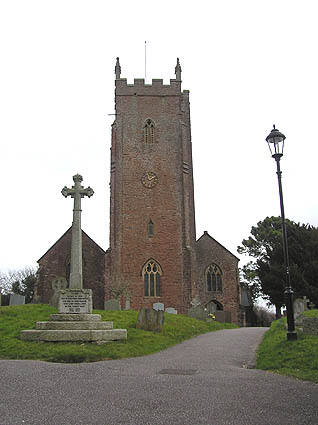
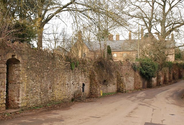
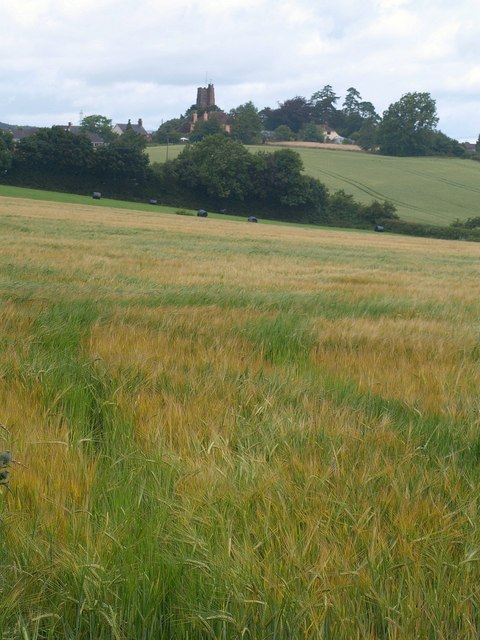
The village center features a range of well-preserved Georgian and Victorian architecture, including the iconic Milverton Church, a Grade I listed building dating back to the 13th century. The church's tower offers stunning panoramic views of the surrounding countryside and is a popular attraction for visitors.

Milverton boasts a strong sense of community, with a variety of local amenities. The village has a primary school, a post office, a village store, and a pub, the Globe Inn, which has been serving locals and tourists alike for over 200 years. The village also hosts regular events and activities, such as fairs, concerts, and sports clubs, fostering a vibrant social life for residents.

Surrounded by rolling hills and lush green landscapes, Milverton provides ample opportunities for outdoor enthusiasts. The village is located close to the Quantock Hills, an Area of Outstanding Natural Beauty, offering extensive walking and cycling trails. Additionally, the nearby Wiveliscombe and Taunton offer further amenities and attractions, including shops, restaurants, and leisure facilities.

Overall, Milverton is a charming and idyllic village with a rich history, a strong sense of community, and stunning natural surroundings, making it an attractive place to live or visit for those seeking a peaceful and picturesque Somerset experience.

If you have any feedback on the listing, please let us know in the comments section below.

Milverton Images

Images are sourced within 2km of 51.02481/-3.2552489 or Grid Reference ST1225. Thanks to Geograph Open Source API. All images are credited.

Milverton: North Street Looking east down this largely Georgian street. Thomas Young, professor of physics at the Royal Institution was born here in 1733. He formulated the wave theory of light and was involved in the decryption of Egyptian hieroglyphs
Milverton: North Street
Looking east down this largely Georgian street. Thomas Young, professor of physics at the Royal Institution was born here in 1733. He formulated the wave theory of light and was involved in the decryption of Egyptian hieroglyphs
Milverton: Fore Street The Globe stands by the turning to Houndsmoor, on the right
Milverton: Fore Street
The Globe stands by the turning to Houndsmoor, on the right
Wiveliscombe: Quakinghouse Lane Behind the camera the lane leads to Fry’s Quaking House and a burial ground for Quakers that appears to date from 1681. Ahead is Duck’s Copse
Wiveliscombe: Quakinghouse Lane
Behind the camera the lane leads to Fry’s Quaking House and a burial ground for Quakers that appears to date from 1681. Ahead is Duck’s Copse
Wiveliscombe: field with new crop; the town in the distance At or near the ploughed field immediately to the right of the tree on the left is the site of a Roman fort, where a hoard of third and fourth century coins was discovered. Roman forts have also been discovered at Clayhanger and at Bolham, near Tiverton
Wiveliscombe: field with new crop; the town in the distance
At or near the ploughed field immediately to the right of the tree on the left is the site of a Roman fort, where a hoard of third and fourth century coins was discovered. Roman forts have also been discovered at Clayhanger and at Bolham, near Tiverton
Milverton: Netherfield The last house in Sand Street, going south west towards Langford Budville
Milverton: Netherfield
The last house in Sand Street, going south west towards Langford Budville
Milverton: Chipley Park Jabiru leads Royal Predica in the first race of the Point-to-Point meeting held here on 5 February 2006
Milverton: Chipley Park
Jabiru leads Royal Predica in the first race of the Point-to-Point meeting held here on 5 February 2006
Milverton: Chipley Park A demonstration by Tiverton Foxhounds at their Point-to-Point meeting held on 5 February 2006
Milverton: Chipley Park
A demonstration by Tiverton Foxhounds at their Point-to-Point meeting held on 5 February 2006
Milverton: Chipley Park 5 February 2006. In the fourth race Fair to to, Sir Norman, Fanion de Nevlliac and Barton Saint tackle one of the fences on this point-to-point circuit. The meeting is held by the Tiverton Foxhounds Hunt.
Milverton: Chipley Park
5 February 2006. In the fourth race Fair to to, Sir Norman, Fanion de Nevlliac and Barton Saint tackle one of the fences on this point-to-point circuit. The meeting is held by the Tiverton Foxhounds Hunt.
Milverton: orchard near Olands A public footpath runs through the orchard to Milverton Court
Milverton: orchard near Olands
A public footpath runs through the orchard to Milverton Court
Milverton: Town Mills Privately owned, these mills would have supplied Milverton with its flour in the 18th and 19th centuries. They stand at the end of a no-through road and were powered by a leat from a weir on the Hillfarrance Brook, half a mile upstream at ST115269. There were two internal overshot waterwheels, driving two sets of machinery. One of the wheels survives in situ
Milverton: Town Mills
Privately owned, these mills would have supplied Milverton with its flour in the 18th and 19th centuries. They stand at the end of a no-through road and were powered by a leat from a weir on the Hillfarrance Brook, half a mile upstream at ST115269. There were two internal overshot waterwheels, driving two sets of machinery. One of the wheels survives in situ
Fitzhead: by Road’s Barn Poultry farm with free-range hens. Eggs for sale here
Fitzhead: by Road’s Barn
Poultry farm with free-range hens. Eggs for sale here
St. Michael's church, Milverton
St. Michael's Hill, Milverton
Milverton: Baghay Farm Many of the farm buildings have recently been converted for residential use. Looking north
Milverton: Baghay Farm
Many of the farm buildings have recently been converted for residential use. Looking north
Milverton: barns at Farthing’s Farm Looking north
Milverton: barns at Farthing’s Farm
Looking north
Milverton: towards Garnival’s Week Farm The track doubles as a public footpath; looking east-north-east
Milverton: towards Garnival’s Week Farm
The track doubles as a public footpath; looking east-north-east
Milverton: road at Preston Bowyer A bend in the Taunton – Wiveliscombe road with Preston Farm to the right. Looking north
Milverton: road at Preston Bowyer
A bend in the Taunton – Wiveliscombe road with Preston Farm to the right. Looking north
Milverton: Limekiln at Aslant Covert Looking south west
Milverton: Limekiln at Aslant Covert
Looking south west
Show me another place!

Milverton is located at Grid Ref: ST1225 (Lat: 51.02481, Lng: -3.2552489)

Administrative County: Somerset

District: Somerset West and Taunton

Police Authority: Avon and Somerset

What 3 Words

///speaker.soups.funds. Near Milverton, Somerset

Related Wikis

Nearby Amenities

Located within 500m of 51.02481,-3.2552489
Milverton
Direction: forward
Source City Limit: sign
Traffic Sign: city_limit
Lat/Long: 51.022436/-3.2574305
Direction: forward
Maxspeed: 20 mph
Source Maxspeed: sign
Traffic Sign: maxspeed
Lat/Long: 51.0275409/-3.2578679
Milverton
Is In: Somerset, England, UK
Place: village
Wikidata: Q2079183
Wikipedia: en:Milverton, Somerset
Lat/Long: 51.0251275/-3.2548397
Give Way
Direction: backward
Lat/Long: 51.0261673/-3.2526363
Give Way
Direction: backward
Lat/Long: 51.0262411/-3.2495358
Historic: memorial
Memorial: war_memorial
Lat/Long: 51.0256472/-3.2543576
Give Way
Direction: forward
Lat/Long: 51.0263853/-3.2542907
Give Way
Direction: forward
Lat/Long: 51.0261061/-3.2528262
Traffic Calming: bump
Lat/Long: 51.0216724/-3.258314
Direction: forward
Maxspeed: 20 mph
Source Maxspeed: sign
Traffic Sign: maxspeed
Lat/Long: 51.0215746/-3.2582885
Give Way
Direction: forward
Lat/Long: 51.0216399/-3.2582578
Direction: backward
Maxspeed: 20 mph
Source Maxspeed: sign
Traffic Sign: maxspeed
Lat/Long: 51.0216319/-3.2580981
Give Way
Direction: forward
Lat/Long: 51.023983/-3.2565276
Give Way
Direction: backward
Lat/Long: 51.0246974/-3.2557042
Give Way
Direction: backward
Lat/Long: 51.0248349/-3.2552375
Give Way
Direction: backward
Lat/Long: 51.0246097/-3.2536979
Give Way
Direction: backward
Lat/Long: 51.0244022/-3.2522106
Give Way
Direction: backward
Lat/Long: 51.0245161/-3.2513241
Give Way
Direction: forward
Lat/Long: 51.0255739/-3.250148
Give Way
Direction: forward
Lat/Long: 51.0256245/-3.2501949
Give Way
Direction: backward
Lat/Long: 51.0216378/-3.2581222
Crossing
Crossing: zebra
Lat/Long: 51.0217648/-3.2583859
Entrance: yes
Lat/Long: 51.025402/-3.2538028
Post Box
Operator: Royal Mail
Operator Wikidata: Q638098
Post Box Design: ludlow
Post Box Type: wall
Ref: TA4 403
Royal Cypher: GVIR
Royal Cypher Wikidata: Q33102169
Lat/Long: 51.0246616/-3.2544866
Gemini
Addr City: Taunton
Addr Postcode: TA4 1JN
Addr Street: Sand Street
Addr Village: Milverton
Shop: hairdresser
Lat/Long: 51.0247349/-3.2552492
The data included in this document is from www.openstreetmap.org. The data is made available under ODbL.

Have you been to Milverton?

Leave your review of Milverton below (or comments, questions and feedback).