Tobar Ashik

Heritage Site in Inverness-shire

Scotland

Tobar Ashik

Footbridge over the Allt Linnidal Looking upstream, with Beinn Dearg Bheag and Beinn na Caillich in the distance.
Footbridge over the Allt Linnidal Credit: John Allan

Tobar Ashik is a historic heritage site located in Inverness-shire, Scotland. Situated near the village of Fort Augustus, this site holds immense cultural and historical significance. Tobar Ashik is a natural spring renowned for its healing properties and has been attracting visitors for centuries.

The site is surrounded by lush greenery and offers a serene and tranquil atmosphere for visitors. The spring water is believed to possess therapeutic qualities, and it is said to have cured various ailments in the past. Many people still flock to Tobar Ashik in the hopes of benefiting from its healing powers.

In addition to its medicinal properties, Tobar Ashik is also steeped in folklore and mythology. Legend has it that the spring was named after a local fairy, Ashik, who was said to have magical powers. It is believed that if visitors make a wish while drinking from the spring, Ashik would grant their wishes.

The heritage site is well-preserved and features a stone wellhouse, which is an architectural marvel in itself. The wellhouse dates back to the early 19th century and is a testament to the site's historical importance.

Tobar Ashik continues to be a popular tourist attraction, drawing visitors from all around the world. Its natural beauty, historical significance, and mythical aura make it a must-visit destination for those interested in Scotland's rich heritage.

If you have any feedback on the listing, please let us know in the comments section below.

Tobar Ashik Images

Images are sourced within 2km of 57.252/-5.838 or Grid Reference NG6824. Thanks to Geograph Open Source API. All images are credited.
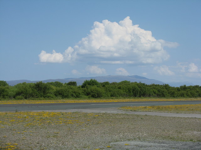
Footbridge over the Allt Linnidal Looking upstream, with Beinn Dearg Bheag and Beinn na Caillich in the distance.
Footbridge over the Allt Linnidal
Looking upstream, with Beinn Dearg Bheag and Beinn na Caillich in the distance.
House at Lower Breakish At the eastern end of the Brecais Iosal road, with a view over the mouth of Ob Bhreacais.
House at Lower Breakish
At the eastern end of the Brecais Iosal road, with a view over the mouth of Ob Bhreacais.
Rockwell Commander 114B at Broadford G-OECM at the airfield on Skye. This 21-year-old aircraft is based at Carlisle
Rockwell Commander 114B at Broadford
G-OECM at the airfield on Skye. This 21-year-old aircraft is based at Carlisle
Apron at Isle of Skye [Ashaig] Airfield The runway is just ahead, running left/right.
Apron at Isle of Skye [Ashaig] Airfield
The runway is just ahead, running left/right.
Welcome Isle of Skye [Ashaig] The Broadford airfield office.
Welcome Isle of Skye [Ashaig]
The Broadford airfield office.
The Isle of Skye Airstrip Plaque commemorating the opening of the airstrip by the Hon. George Younger on 14 April 1972. Constructed by the Corps of Royal Engineers, 1969-1971.
The Isle of Skye Airstrip
Plaque commemorating the opening of the airstrip by the Hon. George Younger on 14 April 1972. Constructed by the Corps of Royal Engineers, 1969-1971.
The Broadford Airstrip on Skye Looking across the runway towards the hills of Applecross.
The Broadford Airstrip on Skye
Looking across the runway towards the hills of Applecross.
A87 through Breakish
Red Skye Restaurant, Breakish This restaurant occupies what was once Breakish school and schoolhouse.
Red Skye Restaurant, Breakish
This restaurant occupies what was once Breakish school and schoolhouse.
Footbridge, Lower Breakish The footbridge carries a path from Waterloo and the Ardnish peninsula to Lower Breakish over the Allt Linnidal.
Footbridge, Lower Breakish
The footbridge carries a path from Waterloo and the Ardnish peninsula to Lower Breakish over the Allt Linnidal.
Ob Bhreacais, Lower Breakish A basalt dyke crosses the head of the inlet, creating a small waterfall on the Allt Linnidal, which appears to be covered at high water.
Ob Bhreacais, Lower Breakish
A basalt dyke crosses the head of the inlet, creating a small waterfall on the Allt Linnidal, which appears to be covered at high water.
Ob Bhreacais, Lower Breakish The estuary of the Allt Linnidal, which separates the Ardnish peninsula and Lower Breakish.
Ob Bhreacais, Lower Breakish
The estuary of the Allt Linnidal, which separates the Ardnish peninsula and Lower Breakish.
Pontoon, Ardnish I've not worked out what this was used for.
Pontoon, Ardnish
I've not worked out what this was used for.
Ardnish An isolated tree on rough grassland. The small outcrops face south or SE.
Ardnish
An isolated tree on rough grassland. The small outcrops face south or SE.
Outcrop, Ardnish This appears to me to be a limestone dyke.
Outcrop, Ardnish
This appears to me to be a limestone dyke.
Rubha Ardnish Eilean na Ruadhaich (mid distance, left of centre) is accessible at low water.
Rubha Ardnish
Eilean na Ruadhaich (mid distance, left of centre) is accessible at low water.
Eilean na Ruadhaich Looking east from the island, which is accessible at low water.
Eilean na Ruadhaich
Looking east from the island, which is accessible at low water.
Eilean na Ruadhaich Looking north from the island, which is accessible at low water.
The islands in the distance are Pabay (left) and the Crowlin Islands (centre).
Eilean na Ruadhaich
Looking north from the island, which is accessible at low water. The islands in the distance are Pabay (left) and the Crowlin Islands (centre).
Show me another place!

Tobar Ashik is located at Grid Ref: NG6824 (Lat: 57.252, Lng: -5.838)

Unitary Authority: Highland

Police Authority: Highlands and Islands

What 3 Words

///equal.encroach.thighs. Near Broadford, Highland

Related Wikis

Ashaig

Ashaig (Scottish Gaelic: Aiseag, referring to a ferry) is a small township, situated adjacent to Upper Breakish and Lower Breakish near Broadford on the...

Broadford Airfield

Isle of Skye (Broadford) Airfield (also known as Ashaig Airstrip or Broadford Aerodrome) is a small airfield on the Isle of Skye, Scotland, with a single...

Lower Breakish

Lower Breakish (Scottish Gaelic: Breacais Ìosal) is a village on the Isle of Skye in Scotland. == Gallery... ==

Upper Breakish

Upper Breakish (Scottish Gaelic: Breacais Àrd) is a village on the Isle of Skye in Scotland in the United Kingdom. == References == The geographic coordinates...

Pabay

Pabay is a Scottish island just off the coast of Skye. The name Pabay is derived from an old Norse word meaning "priest's isle" and there are the remains...

Harrapool

Harrapool (Scottish Gaelic: Harrapul) is a village, that lies on the right hand side of Broadford Bay, in Isle of Skye, Scottish Highlands and is in the...

Ross, Skye and Lochaber (UK Parliament constituency)

Ross, Skye and Lochaber is a constituency of the House of Commons of the Parliament of the United Kingdom (Westminster). It elects one Member of Parliament...

Broadford, Skye

Broadford (Scottish Gaelic: An t-Àth Leathann [ən̪ˠ t̪aːh ˈʎɛhən̪ˠ]), together with nearby Harrapool, is the second-largest settlement on the Isle of Skye...

Nearby Amenities

Located within 500m of 57.252,-5.838
Source: PGS
Lat/Long: 57.2537542/-5.8304254
Source: PGS
Lat/Long: 57.2535884/-5.8309373
Source: PGS
Lat/Long: 57.2533256/-5.8317251
Created By: almien_coastlines
Source: PGS
Lat/Long: 57.253652/-5.831564
Source: PGS
Lat/Long: 57.2535218/-5.8326577
Created By: almien_coastlines
Source: PGS
Lat/Long: 57.253237/-5.83295
Source: PGS
Lat/Long: 57.2529967/-5.8333085
Source: PGS
Lat/Long: 57.2529089/-5.8335663
Source: PGS
Lat/Long: 57.2528423/-5.8339902
Source: PGS
Lat/Long: 57.2526475/-5.8344152
Source: PGS
Lat/Long: 57.2523686/-5.8346659
Source: PGS
Lat/Long: 57.2522723/-5.8347338
Source: PGS
Lat/Long: 57.2521102/-5.8347357
Created By: almien_coastlines
Source: PGS
Lat/Long: 57.251916/-5.834739
Created By: almien_coastlines
Source: PGS
Lat/Long: 57.252022/-5.835692
Source: PGS
Lat/Long: 57.2513873/-5.8358424
Source: PGS
Lat/Long: 57.250913/-5.8455226
Created By: almien_coastlines
Source: PGS
Lat/Long: 57.250541/-5.844557
Created By: almien_coastlines
Source: PGS
Lat/Long: 57.250675/-5.844332
Created By: almien_coastlines
Source: PGS
Lat/Long: 57.250807/-5.844105
Source: PGS
Lat/Long: 57.2509454/-5.843243
Source: PGS
Lat/Long: 57.2524671/-5.8416144
Source: PGS
Lat/Long: 57.2514299/-5.8442032
Created By: almien_coastlines
Source: PGS
Lat/Long: 57.251181/-5.844607
Created By: Merkaartor 0.12
Lat/Long: 57.2486699/-5.8413539
Barrier: stile
Source: survey
Lat/Long: 57.2508877/-5.8354858
Tobar Aiseig
Alt Name: St Maelrubha's Well
Natural: spring
Source: survey
Lat/Long: 57.2506312/-5.835505
Bench
Source: survey
Lat/Long: 57.249637/-5.835994
Power: pole
Lat/Long: 57.2488138/-5.8426999
Power: pole
Lat/Long: 57.2485971/-5.8434306
Òb Bhreacais
Natural: bay
Lat/Long: 57.2511415/-5.8405844
The data included in this document is from www.openstreetmap.org. The data is made available under ODbL.

Have you been to Tobar Ashik?

Leave your review of Tobar Ashik below (or comments, questions and feedback).