The Dodman and St Austell Bay

Heritage Site in Cornwall

England

The Dodman and St Austell Bay

Cross at Dodman Point
Cross at Dodman Point Credit: don cload

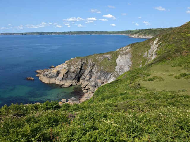
The Dodman and St Austell Bay, located in Cornwall, England, is a significant heritage site that encompasses a stunning natural landscape and holds historical value. The Dodman, also known as Dodman Point, is a prominent headland situated on the southern coastline of Cornwall.

Rising to an impressive height of 110 meters (360 feet), the Dodman offers breathtaking panoramic views of the surrounding St Austell Bay and the English Channel. Its commanding position has made it a vital landmark for mariners, guiding ships safely along the coast for centuries. The headland is also home to a distinctive granite cross, known as the Dodman Cross, which has stood as a navigational aid since the early 19th century.

The area surrounding the Dodman is rich in history, with evidence of human activity dating back to the Iron Age. Archaeological excavations have revealed the remains of ancient settlements, including Iron Age ramparts, burial mounds, and a medieval chapel. These archaeological sites provide valuable insights into the region's past and have contributed to a better understanding of the area's cultural heritage.

In addition to its historical significance, the Dodman and St Austell Bay also boast diverse ecosystems and wildlife. The headland is a designated Area of Outstanding Natural Beauty, offering a haven for various bird species and other wildlife. Visitors can explore the picturesque coastal paths, enjoy the unspoiled beaches, and engage in activities like birdwatching, hiking, and photography.

Overall, the Dodman and St Austell Bay in Cornwall offer a unique combination of natural beauty and historical significance, making it a cherished heritage site that attracts both locals and tourists alike.

If you have any feedback on the listing, please let us know in the comments section below.

The Dodman and St Austell Bay Images

Images are sourced within 2km of 50.227/-4.808 or Grid Reference SW9940. Thanks to Geograph Open Source API. All images are credited.

Cross at Dodman Point
Coast path at the Bulwark The bank is obscured by tall bracken. You get a much better idea from <a href="https://www.geograph.org.uk/photo/4457128">SX0039 : Path junction near the Bulwark on Dodman Point</a>, taken at the same spot. But this image does include Bow (or is it Vault) Beach in the background. The bulwark is the northern earthwork enclosing cliff castle <span class="nowrap"><a title="https://www.historicengland.org.uk/listing/the-list/list-entry/1020865" rel="nofollow ugc noopener" href="https://www.historicengland.org.uk/listing/the-list/list-entry/1020865">Link</a><img style="margin-left:2px;" alt="External link" title="External link - shift click to open in new window" src="https://s1.geograph.org.uk/img/external.png" width="10" height="10"/></span>
Coast path at the Bulwark
The bank is obscured by tall bracken. You get a much better idea from SX0039 : Path junction near the Bulwark on Dodman Point, taken at the same spot. But this image does include Bow (or is it Vault) Beach in the background. The bulwark is the northern earthwork enclosing cliff castle LinkExternal link
Cattle south of Penare From a footpath that follows the bulwark around the Dodman cliff castle to link the coast path northwest and northnortheast of the point.
Cattle south of Penare
From a footpath that follows the bulwark around the Dodman cliff castle to link the coast path northwest and northnortheast of the point.
Trig pillar and Watch House, Dodman Point
Near Dodman Point Looking towards Bow or Vault Beach.
Near Dodman Point
Looking towards Bow or Vault Beach.
View to the coast from the path to Dodman Point
Dodman Trig Point Flush Bracket S1748 and Watch Tower
Gell Point
Gell Point
Dodman Point Beautiful to the eye, this headland has a nasty reputation amongst mariners throughout the ages.
Dodman Point
Beautiful to the eye, this headland has a nasty reputation amongst mariners throughout the ages.
Stone Cross, Dodman Point
The Dodman
The Dodman
Cross at Dodman Point
Dodman Meadow The meadow land on the Dodman promontory covers the site of an ancient hillfort. In the distance are the hills of the St Austell Granite.
Dodman Meadow
The meadow land on the Dodman promontory covers the site of an ancient hillfort. In the distance are the hills of the St Austell Granite.
Dodman from the south west
Dodman from due south
The cross at Dodman Point
Cross on Dodman Point Approaching this cross on Dodman Point I assumed it was a war memorial, in fact it predates the twentieth century and was erected in 1896 in the hope of the second coming of Jesus Christ.
Cross on Dodman Point
Approaching this cross on Dodman Point I assumed it was a war memorial, in fact it predates the twentieth century and was erected in 1896 in the hope of the second coming of Jesus Christ.
On Dodman Point View to the east from Dodman Point.
On Dodman Point
View to the east from Dodman Point.
Show me another place!

The Dodman and St Austell Bay is located at Grid Ref: SW9940 (Lat: 50.227, Lng: -4.808)

Unitary Authority: Cornwall

Police Authority: Devon and Cornwall

What 3 Words

///tubes.televise.pulses. Near Mevagissey, Cornwall

Related Wikis

Penare

Penare is a hamlet near Gorran Haven in Cornwall, England, UK. Penare is situated 1 mile (2 km) south-west of Gorran Haven.Pronunciation is PEA - NAR....

Hemmick Beach

Hemmick Beach is a west-facing beach on the south coast of Cornwall, England. It is situated at the east end of Veryan Bay, on the west side of the Dodman...
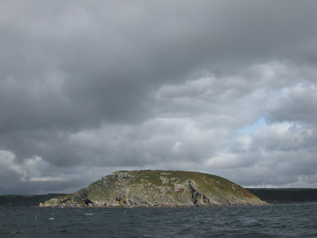
Dodman Point

Dodman Point (Cornish: Penn Den Varow) near Mevagissey is the highest headland on the south Cornwall coast, measuring 374 feet (114 m). It is also known...

Vault Beach

Vault Beach (also Bow Beach) is situated on the south coast of Cornwall, England, UK, near Gorran Haven. The beach consists mainly of shingle but does...

Boswinger

Boswinger is a village in south Cornwall, England, two miles south of Mevagissey (where the 2011 Census population is included). There is a youth hostel...
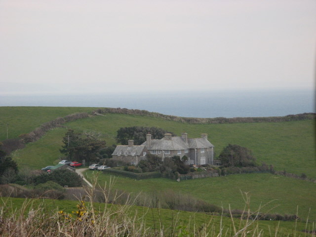
Lamledra

Lamledra is a house near Gorran Haven in Cornwall, England, UK. It is situated immediately above Vault Beach. It was built in 1911 by the barrister, John...
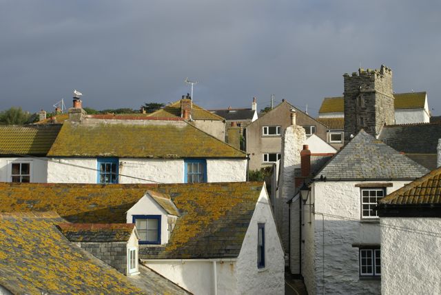
Gorran Haven

Gorran Haven (Cornish: Porthust) is a fishing village, in the civil parish of St Goran, on the south coast of Cornwall, England, UK. It is about 2 miles...

St Goran

St Goran is a coastal civil parish in Cornwall, England, UK, six miles (10 km) south-southwest of St Austell. The largest settlement in the parish is the...

Nearby Amenities

Located within 500m of 50.227,-4.808
Source: PGS
Lat/Long: 50.2288774/-4.8129147
Source: PGS
Lat/Long: 50.228688/-4.812708
Source: PGS
Lat/Long: 50.2276509/-4.8124651
Source: PGS
Lat/Long: 50.2273817/-4.8123521
Source: PGS
Lat/Long: 50.2272248/-4.8121869
Source: PGS
Lat/Long: 50.2269864/-4.8122177
Source: PGS
Lat/Long: 50.2260117/-4.8122607
Source: PGS
Lat/Long: 50.2249958/-4.8126254
Source: PGS
Lat/Long: 50.2249443/-4.8123395
Source: PGS
Lat/Long: 50.2247625/-4.8119603
Source: PGS
Lat/Long: 50.2249684/-4.8119603
Source: PGS
Lat/Long: 50.2249454/-4.8111439
Source: PGS
Lat/Long: 50.2249637/-4.8109234
Source: PGS
Lat/Long: 50.224735/-4.8104368
Source: PGS
Lat/Long: 50.2242957/-4.8103509
Source: PGS
Lat/Long: 50.223654/-4.810662
Source: PGS
Lat/Long: 50.2231013/-4.810587
Source: PGS
Lat/Long: 50.2229229/-4.8104153
Source: PGS
Lat/Long: 50.22317/-4.8099003
Source: PGS
Lat/Long: 50.223019/-4.8096857
Source: PGS
Lat/Long: 50.2232523/-4.8094926
Source: PGS
Lat/Long: 50.2229436/-4.8084671
Source: PGS
Lat/Long: 50.2227125/-4.8084507
Kerb: no
Lat/Long: 50.2299339/-4.806772
Gell Pool
Place: locality
Source: OS_OpenData_StreetView
Lat/Long: 50.2244016/-4.8114007
Long Rock
Place: locality
Source: OS_OpenData_StreetView
Lat/Long: 50.2265431/-4.8135465
Helencane
Place: locality
Source: OS_OpenData_StreetView
Lat/Long: 50.2284646/-4.8141999
Gell Point
Place: locality
Source: OS_OpenData_StreetView
Lat/Long: 50.2244578/-4.812987
Barrier: stile
Stile: squeezer
Lat/Long: 50.2289424/-4.8119663
Bench
Backrest: no
Lat/Long: 50.2244362/-4.8078342
Barrier: kissing_gate
Image: https://archive.org/details/2020gorranhaven/Gorran%20Haven%202020-08-24/IMG_20200824_135621.jpg
Material: wood
Lat/Long: 50.2302273/-4.8052777
Barrier: stile
Foot: yes
Image: https://archive.org/details/2020gorranhaven/Gorran%20Haven%202020-08-24/IMG_20200824_135437.jpg
Material: stone
Stile: stepover
Wheelchair: no
Lat/Long: 50.2304645/-4.8044982
The Dodman
Hiking: yes
Image: https://archive.org/details/dodmanpoint/Dodman%20Point%202020-08-28/IMG_20200828_133755.jpg
Information: map
Operator: National Trust
Tourism: information
Lat/Long: 50.2297752/-4.8062041
Hiking: yes
Image: https://archive.org/details/dodmanpoint/Dodman%20Point%202020-08-28/IMG_20200828_133746.jpg
Information: guidepost
Operator: National Trust
Tourism: information
Lat/Long: 50.2296808/-4.8061669
Barrier: stile
Foot: yes
Image: https://archive.org/details/dodmanpoint/Dodman%20Point%202020-08-28/DSCN2319.JPG
Stile: stepover
Lat/Long: 50.2251551/-4.8017824
Hiking: yes
Image: https://archive.org/details/dodmanpoint/Dodman%20Point%202020-08-28/DSCN2304.JPG
Information: guidepost
Operator: National Trust
Tourism: information
Lat/Long: 50.226089/-4.8021787
Bench
Backrest: no
Survey Date: 2023-03-26
Lat/Long: 50.2308887/-4.809424
Barrier: stile
Lat/Long: 50.2301622/-4.8118572
The data included in this document is from www.openstreetmap.org. The data is made available under ODbL.

Have you been to The Dodman and St Austell Bay?

Leave your review of The Dodman and St Austell Bay below (or comments, questions and feedback).