The Castle

Heritage Site in Pembrokeshire

Wales

The Castle

Lane to Stockpark On a drizzly September evening.
Lane to Stockpark Credit: David Lally

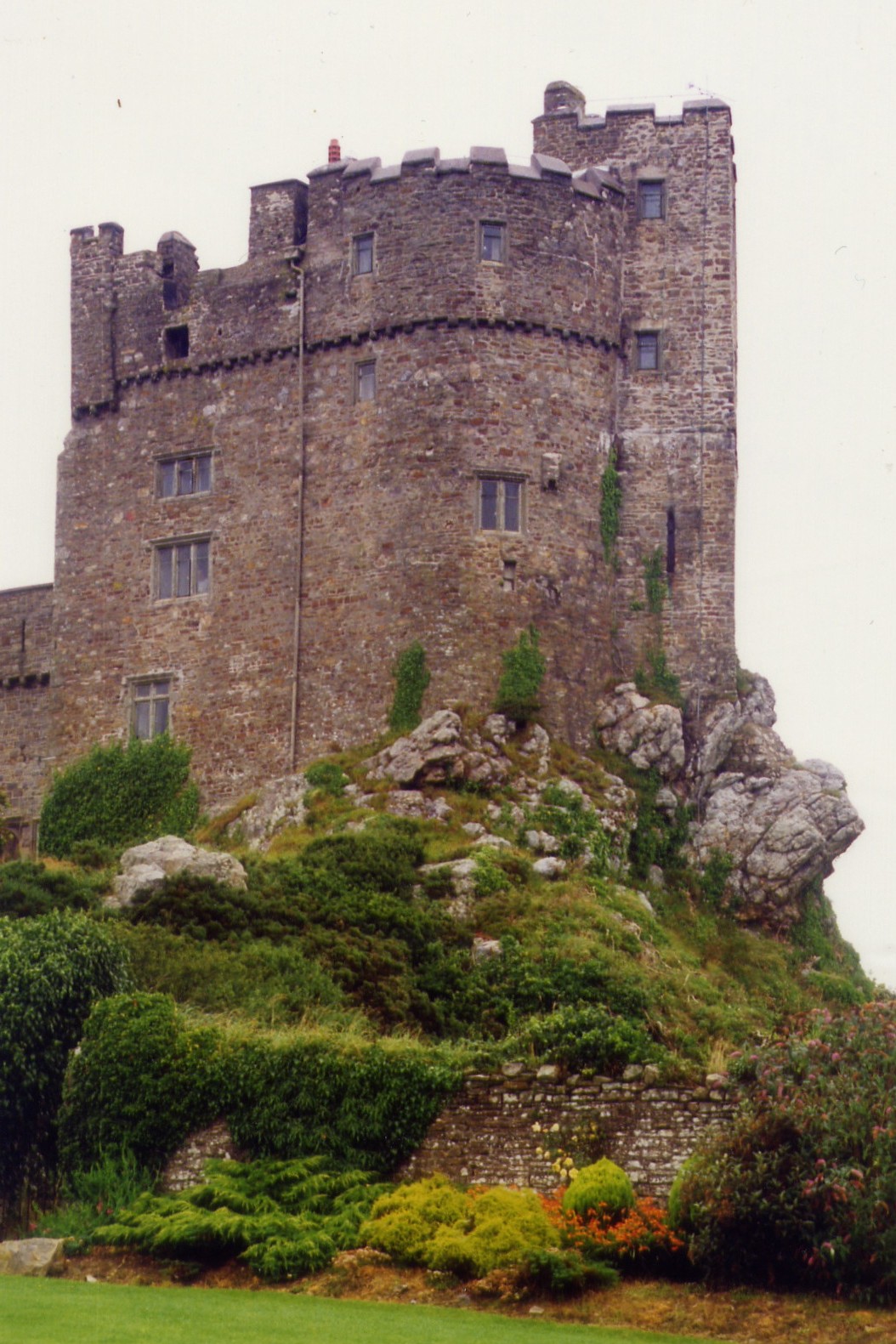
The Castle, located in Pembrokeshire, Wales, is a historic heritage site that dates back to the medieval period. It is situated on a rocky promontory overlooking the picturesque town of Pembroke and the River Cleddau. The Castle is known for its impressive stone walls, towers, and gatehouse, which are well-preserved and provide visitors with a glimpse into the past.

Constructed in the 11th century by the Normans, The Castle has a rich and storied history, playing a significant role in various conflicts and battles throughout the centuries. It was later extensively renovated and expanded by the Tudor dynasty, adding to its architectural significance and grandeur.

Visitors to The Castle can explore the grounds, climb the towers for panoramic views of the surrounding countryside, and learn about its fascinating history through informative displays and guided tours. The site is also used for various events and activities, such as reenactments, concerts, and medieval fairs, making it a popular destination for tourists and locals alike.

Overall, The Castle in Pembrokeshire is a must-visit for history enthusiasts, offering a captivating glimpse into Wales' medieval past and providing a unique and immersive experience for visitors of all ages.

If you have any feedback on the listing, please let us know in the comments section below.

The Castle Images

Images are sourced within 2km of 51.833/-5.055 or Grid Reference SM8919. Thanks to Geograph Open Source API. All images are credited.

Lane to Stockpark On a drizzly September evening.
Lane to Stockpark
On a drizzly September evening.
Camrose Brook
Camrose Brook
Field and woodland Near Summerhill Mill.
Field and woodland
Near Summerhill Mill.
Lane From Keeston Towards Summerhill Mill
Lane From Keeston
Towards Summerhill Mill
Road junction near Keeston This is the junction of the A487 leading to Haverfordwest and the minor road for Keeston and Camrose.
Road junction near Keeston
This is the junction of the A487 leading to Haverfordwest and the minor road for Keeston and Camrose.
Sculptured Head This sculptured head can be found in the woods beside the highest lake which is full of trout. The sculpture reminds you of Easter Island.
Sculptured Head
This sculptured head can be found in the woods beside the highest lake which is full of trout. The sculpture reminds you of Easter Island.
Bus shelter and stop, Simpson Cross Bus shelter and stop by the A487 at Simpson Cross.
Bus shelter and stop, Simpson Cross
Bus shelter and stop by the A487 at Simpson Cross.
View from Simpson Hill Farm near Simpsons Cross
A Horse on Simpsons Hill Farm
A487 at Simpson Cross boundary
A487 at Little Hilton Farm
Simpson South Farm Looking south-west down the farm drive from the road.
Simpson South Farm
Looking south-west down the farm drive from the road.
Ordnance Survey Flush Bracket 11508 This can be found on the wall of an old farm building at Kerrin Cottage.
For more detail see : <span class="nowrap"><a title="http://www.bench-marks.org.uk/bm22523" rel="nofollow ugc noopener" href="http://www.bench-marks.org.uk/bm22523">Link</a><img style="margin-left:2px;" alt="External link" title="External link - shift click to open in new window" src="https://s1.geograph.org.uk/img/external.png" width="10" height="10"/></span>
Ordnance Survey Flush Bracket 11508
This can be found on the wall of an old farm building at Kerrin Cottage. For more detail see : LinkExternal link
The lane to Keeston Moor Looking south towards Moor Hall.
The lane to Keeston Moor
Looking south towards Moor Hall.
Keeston Hill A spooky mist hung over the lower ground
Keeston Hill
A spooky mist hung over the lower ground
Cuffern Manor Built around 1770 by John Rees Stokes.  The Manor has had a lively history, including three significant fires [one since this photograph was taken].
It was a hotel in the 1960's, then became a nursing home and has now become a hotel again. <span class="nowrap"><a title="http://www.cuffernmanor.co.uk/history/" rel="nofollow ugc noopener" href="http://www.cuffernmanor.co.uk/history/">Link</a><img style="margin-left:2px;" alt="External link" title="External link - shift click to open in new window" src="https://s1.geograph.org.uk/img/external.png" width="10" height="10"/></span>
Cuffern Manor
Built around 1770 by John Rees Stokes. The Manor has had a lively history, including three significant fires [one since this photograph was taken]. It was a hotel in the 1960's, then became a nursing home and has now become a hotel again. LinkExternal link
Potato field near Simpson Cross Looking north-west from the road between Simpson Cross and Nolton Cross.
Potato field near Simpson Cross
Looking north-west from the road between Simpson Cross and Nolton Cross.
Potato field ready for harvest The leaves have been pruned from the plants in preparation for harvest. Looking north-west towards the farmyard at Woodlands Edge.
Potato field ready for harvest
The leaves have been pruned from the plants in preparation for harvest. Looking north-west towards the farmyard at Woodlands Edge.
Show me another place!

The Castle is located at Grid Ref: SM8919 (Lat: 51.833, Lng: -5.055)

Unitary Authority: Pembrokeshire

Police Authority: Dyfed Powys

What 3 Words

///maps.glassware.heartache. Near Camrose, Pembrokeshire

Nearby Locations

Keeston Hill The Castle

Related Wikis

Pembrokeshire Motor Museum

The Pembrokeshire Motor Museum used to exhibit a range of restored vintage cars. It was located at Simpson Cross, in Pembrokeshire, West Wales on the A487...

Pembrokeshire Coast National Park

Pembrokeshire Coast National Park (Welsh: Parc Cenedlaethol Arfordir Penfro) is a national park along the Pembrokeshire coast in west Wales. It was established...

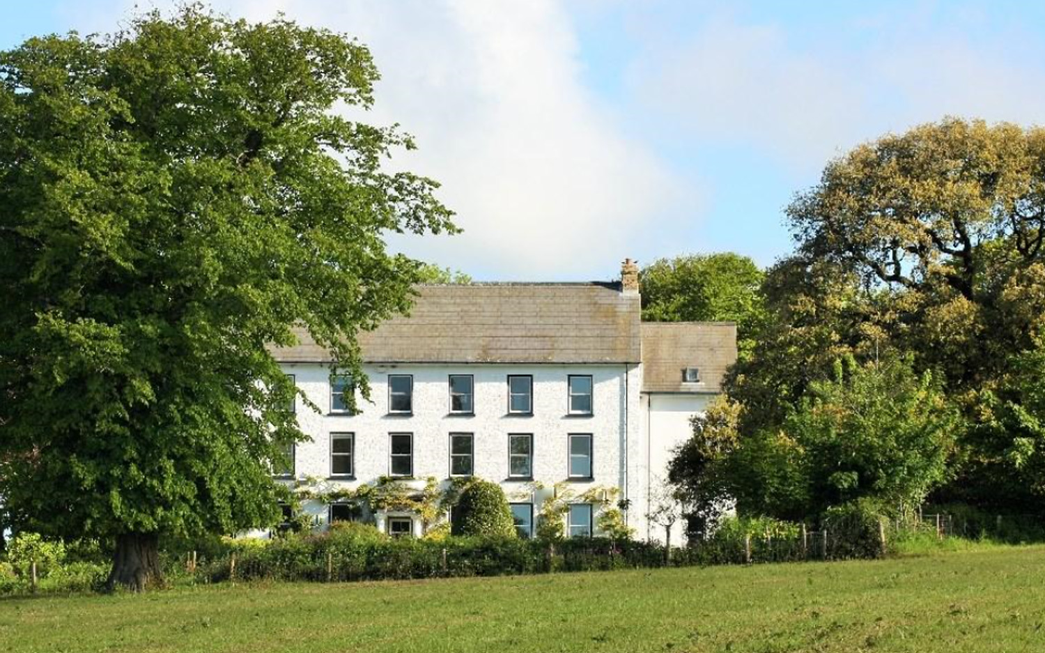
Cuffern Manor, Pembrokeshire

Cuffern Manor in Roch, Pembrokeshire is a house of historical significance and is listed on the Wales Heritage Register. It was built in 1770 by John Rees...

Roch Castle

Roch Castle (Welsh: Castell y Garn) is a 12th-century castle, located at Roch near Haverfordwest, Wales. Built by Norman knight Adam de Rupe in the second...

Nearby Amenities

Located within 500m of 51.833,-5.055
Keeston
Place: village
Lat/Long: 51.8336705/-5.0478529
Give Way
Direction: forward
Lat/Long: 51.8326048/-5.0604575
Direction: 190
Generator Method: photovoltaic
Generator Output Electricity: yes
Generator Solar Modules: 12
Generator Source: solar
Generator Type: solar_photovoltaic_panel
Location: roof
Power: generator
Lat/Long: 51.8328439/-5.0620446
Direction: 170
Generator Method: photovoltaic
Generator Output Electricity: yes
Generator Solar Modules: 18
Generator Source: solar
Generator Type: solar_photovoltaic_panel
Location: roof
Power: generator
Lat/Long: 51.8320578/-5.0617402
Direction: 145
Generator Method: photovoltaic
Generator Output Electricity: yes
Generator Solar Modules: 16
Generator Source: solar
Generator Type: solar_photovoltaic_panel
Location: roof
Power: generator
Lat/Long: 51.8323416/-5.0608805
Direction: SSW
Generator Method: photovoltaic
Generator Output Electricity: yes
Generator Solar Modules: 16
Generator Source: solar
Generator Type: solar_photovoltaic_panel
Location: roof
Power: generator
Lat/Long: 51.833177/-5.060977
Direction: 215
Generator Method: photovoltaic
Generator Output Electricity: yes
Generator Solar Modules: 16
Generator Source: solar
Generator Type: solar_photovoltaic_panel
Location: roof
Power: generator
Lat/Long: 51.8331725/-5.0497051
Direction: 190
Generator Method: photovoltaic
Generator Output Electricity: yes
Generator Solar Modules: 6
Generator Source: solar
Generator Type: solar_photovoltaic_panel
Location: roof
Power: generator
Lat/Long: 51.8316836/-5.0481829
Direction: S
Generator Method: photovoltaic
Generator Output Electricity: yes
Generator Solar Modules: 6
Generator Source: solar
Generator Type: solar_photovoltaic_panel
Location: roof
Power: generator
Lat/Long: 51.8320068/-5.0479469
Direction: 215
Generator Method: photovoltaic
Generator Output Electricity: yes
Generator Solar Modules: 6
Generator Source: solar
Generator Type: solar_photovoltaic_panel
Location: roof
Power: generator
Lat/Long: 51.8321875/-5.0479442
Direction: SW
Generator Method: photovoltaic
Generator Output Electricity: yes
Generator Solar Modules: 16
Generator Source: solar
Generator Type: solar_photovoltaic_panel
Location: roof
Power: generator
Lat/Long: 51.8317653/-5.0500604
Direction: 190
Generator Method: photovoltaic
Generator Output Electricity: yes
Generator Solar Modules: 15
Generator Source: solar
Generator Type: solar_photovoltaic_panel
Location: roof
Power: generator
Lat/Long: 51.8317383/-5.0504333
Give Way
Direction: forward
Lat/Long: 51.8304648/-5.052584
Bus Stop
Bus: yes
Public Transport: platform
Shelter: yes
Lat/Long: 51.8302953/-5.0519496
Bus Stop
Bus: yes
Public Transport: platform
Lat/Long: 51.832737/-5.0621486
Man Made: utility_pole
Lat/Long: 51.8357096/-5.0493742
Man Made: utility_pole
Lat/Long: 51.8350794/-5.0496792
Man Made: utility_pole
Lat/Long: 51.8344911/-5.0502462
Man Made: utility_pole
Lat/Long: 51.8346453/-5.0492202
Keeston Hill Farm
Place: farm
Lat/Long: 51.8311712/-5.0531282
Man Made: utility_pole
Lat/Long: 51.8319232/-5.0541716
Man Made: utility_pole
Lat/Long: 51.8315368/-5.0575573
The data included in this document is from www.openstreetmap.org. The data is made available under ODbL.

Have you been to The Castle?

Leave your review of The Castle below (or comments, questions and feedback).