St Molnag's Chapel

Heritage Site in Inverness-shire

Scotland

St Molnag's Chapel

Ferry arriving at Clachan, Raasay
Ferry arriving at Clachan, Raasay Credit: Sandy Gerrard

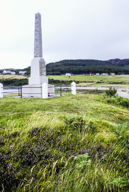
St Molnag's Chapel is a historic religious site located in Inverness-shire, Scotland. Situated on the eastern shore of Loch Ness, this ancient chapel is considered a significant heritage site, attracting visitors from all over the world. Dating back to the 13th century, it is believed to have been founded by St Molnag, a Celtic saint who resided in the area during the early medieval period.

The chapel is constructed in the traditional Scottish architectural style, featuring a rectangular shape with a simple stone exterior. The interior comprises a single nave with a small altar at the eastern end. The chapel's walls are adorned with religious symbols and ancient carvings, reflecting the rich history of the site.

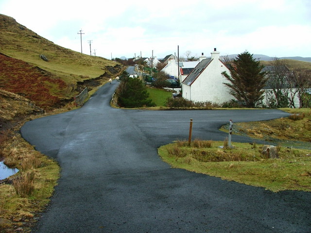
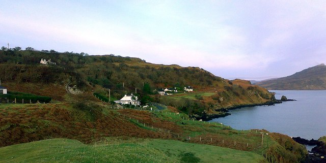
St Molnag's Chapel offers breathtaking views of the surrounding landscape, with Loch Ness stretching out in front of it and the majestic mountains of the Scottish Highlands in the distance. The tranquil ambiance and picturesque setting make it a popular spot for contemplation and reflection.

While the chapel is no longer used for regular worship, it remains an important pilgrimage site for individuals seeking spiritual solace and a connection to Scotland's religious past. Visitors can explore the chapel grounds, marvel at the ancient architecture, and learn about the fascinating legends associated with St Molnag and the area's early Christian heritage.

Preservation efforts have been made to maintain the chapel's historical integrity, ensuring that future generations can continue to appreciate its significance. St Molnag's Chapel stands as a testament to Scotland's religious and cultural heritage, providing a glimpse into the past for visitors and historians alike.

If you have any feedback on the listing, please let us know in the comments section below.

St Molnag's Chapel Images

Images are sourced within 2km of 57.353/-6.082 or Grid Reference NG5436. Thanks to Geograph Open Source API. All images are credited.

Ferry arriving at Clachan, Raasay
Cut Mark, Home Farm, Raasay Not shown on modern OS DB but shown on Six-inch 2nd and later editions, 1892-1960
Cut Mark, Home Farm, Raasay
Not shown on modern OS DB but shown on Six-inch 2nd and later editions, 1892-1960
Corner of Home Farm, Raasay
OS Pivot, Raasay House, Raasay Not shown on modern OS DB but shown on Six-inch 2nd and later editions, 1892-1960.
OS Pivot, Raasay House, Raasay
Not shown on modern OS DB but shown on Six-inch 2nd and later editions, 1892-1960.
Oskaig Point
Oskaig Point
Dismantled railway, Raasay Used to transport iron ore from the mines down to the ironworks, which were active during the First World War. The land is now used for grazing cattle. The red hills of Skye are in the background, with Glamaig prominent.
Dismantled railway, Raasay
Used to transport iron ore from the mines down to the ironworks, which were active during the First World War. The land is now used for grazing cattle. The red hills of Skye are in the background, with Glamaig prominent.
Dismantled railway, Raasay Used to transport iron ore from the mines down to the ironworks, which were active during the First World War. The red hills of Skye are in the background, with Glamaig prominent.
Dismantled railway, Raasay
Used to transport iron ore from the mines down to the ironworks, which were active during the First World War. The red hills of Skye are in the background, with Glamaig prominent.
Ruined mine building, Raasay No.1 Mine was active during the First World War. A railway was used to transport iron ore down to the ironworks at Suisnish. The red hills of Skye are in the background, with Glamaig prominent.
Ruined mine building, Raasay
No.1 Mine was active during the First World War. A railway was used to transport iron ore down to the ironworks at Suisnish. The red hills of Skye are in the background, with Glamaig prominent.
Entrance to Raasay No.1 Mine, August 1995 The mine was developed before WWI by the William Baird Company to supply ironstone to their iron-smelting works in Lanarkshire and Ayrshire. The entrance to the mine was by the adit driven into the hillside beyond the white notice.
Further information with many photographs can be seen on the Canmore website - <span class="nowrap"><a title="https://canmore.org.uk/site/11465/raasay-no1-mine" rel="nofollow ugc noopener" href="https://canmore.org.uk/site/11465/raasay-no1-mine">Link</a><img style="margin-left:2px;" alt="External link" title="External link - shift click to open in new window" src="https://s1.geograph.org.uk/img/external.png" width="10" height="10"/></span> .
A railway was used to transport ore from the site to be exported via the old wooden pier at Suisnish - <a title="https://www.geograph.org.uk/photo/5761128" href="https://www.geograph.org.uk/photo/5761128">Link</a> . The 'bridge' in the foreground of the image is over a stream; presumably when intact it carried the rail track.
Entrance to Raasay No.1 Mine, August 1995
The mine was developed before WWI by the William Baird Company to supply ironstone to their iron-smelting works in Lanarkshire and Ayrshire. The entrance to the mine was by the adit driven into the hillside beyond the white notice. Further information with many photographs can be seen on the Canmore website - LinkExternal link . A railway was used to transport ore from the site to be exported via the old wooden pier at Suisnish - Link . The 'bridge' in the foreground of the image is over a stream; presumably when intact it carried the rail track.
Raasay War memorial at Inverarish Inverarish is the largest settlement on Raasay making it the logical location for the island's war memorial. The village looks out over the Narrows of Raasay to Skye, just a kilometre or two distant.
Raasay War memorial at Inverarish
Inverarish is the largest settlement on Raasay making it the logical location for the island's war memorial. The village looks out over the Narrows of Raasay to Skye, just a kilometre or two distant.
View near Oskaig On the west coast of Raasay with Skye in the distance.
From a print, date uncertain.
View near Oskaig
On the west coast of Raasay with Skye in the distance. From a print, date uncertain.
Road above Oskaig Plantation Looking towards Orchard Wood.
From a print, date approximate.
Road above Oskaig Plantation
Looking towards Orchard Wood. From a print, date approximate.
Piers of former railway viaduct The viaduct carried by these piers carried a rope-worked railway built during the First World War to serve a nearby iron mine.
Piers of former railway viaduct
The viaduct carried by these piers carried a rope-worked railway built during the First World War to serve a nearby iron mine.
Abandoned mine building Derelict building at the site of Raasay Mine 2, a short lived iron mine believed to have seen little production due to geological faulting. It was connected to a processing plant at Suisnish by a rope-worked railway.
Abandoned mine building
Derelict building at the site of Raasay Mine 2, a short lived iron mine believed to have seen little production due to geological faulting. It was connected to a processing plant at Suisnish by a rope-worked railway.
Abandoned mine building Derelict building at Raasay Mine 2, a short lived Iron mine that operated during the First World War.
Abandoned mine building
Derelict building at Raasay Mine 2, a short lived Iron mine that operated during the First World War.
Landscape around Raasay Free Church View Towards Raasay Free Church from Dun Borodale.
Landscape around Raasay Free Church
View Towards Raasay Free Church from Dun Borodale.
The Manse Former Free Church manse.  Now a holiday cottage.
The Manse
Former Free Church manse. Now a holiday cottage.
Railway Viaduct Abutment Abutment of former viaduct across Inverarish Burn on the railway leading to Raasay Mine 2, an iron mine that operated briefly during World War I.
Railway Viaduct Abutment
Abutment of former viaduct across Inverarish Burn on the railway leading to Raasay Mine 2, an iron mine that operated briefly during World War I.
Show me another place!

St Molnag's Chapel is located at Grid Ref: NG5436 (Lat: 57.353, Lng: -6.082)

Unitary Authority: Highland

Police Authority: Highlands and Islands

What 3 Words

///rich.mirroring.poem. Near Portree, Highland

Related Wikis

Isle of Raasay distillery

Isle of Raasay distillery is a Scotch whisky distillery on the Inner Hebridean Isle of Raasay in Northwest Scotland. The distillery is owned by R&B Distillers...

Inverarish

Inverarish (Scottish Gaelic: Inbhir Àrais) is a village that is the main settlement of the Isle of Raasay, in the civil parish of Portree, in the council...

Peinachorran

Peinchorran (Scottish Gaelic: Peighinn a' Chorrain; Peinachorrain on Ordnance Survey maps) is a remote settlement, lying at the end of the B883 road, on...

Gedintailor

Gedintailor (Scottish Gaelic: Gead an t-Sailleir) is a crofting village, lying on the shores of the Narrows of Raasay on the east coast of the island of...

Nearby Amenities

Located within 500m of 57.353,-6.082
Source: PGS
Lat/Long: 57.3500303/-6.0881188
Source: PGS
Lat/Long: 57.3499348/-6.087903
Source: PGS
Lat/Long: 57.3498003/-6.0764307
Source: PGS
Lat/Long: 57.350289/-6.0769101
Source: PGS
Lat/Long: 57.3505074/-6.076964
Source: PGS
Lat/Long: 57.3509196/-6.0797336
Source: PGS
Lat/Long: 57.3508525/-6.0809062
Source: PGS
Lat/Long: 57.3506466/-6.0811035
Source: PGS
Lat/Long: 57.3504783/-6.0810458
Source: PGS
Lat/Long: 57.3504022/-6.0813048
Source: PGS
Lat/Long: 57.3503848/-6.081753
Source: PGS
Lat/Long: 57.3507823/-6.082432
Source: PGS
Lat/Long: 57.3516476/-6.0822275
Source: PGS
Lat/Long: 57.3516732/-6.0823139
Source: PGS
Lat/Long: 57.3522057/-6.0833183
Source: PGS
Lat/Long: 57.3522353/-6.0837289
Source: PGS
Lat/Long: 57.3520505/-6.0845163
Source: PGS
Lat/Long: 57.3514976/-6.0847192
Source: PGS
Lat/Long: 57.3512828/-6.0848675
Source: PGS
Lat/Long: 57.3507986/-6.0860764
Source: PGS
Lat/Long: 57.3506902/-6.0862917
Source: PGS
Lat/Long: 57.3505901/-6.086477
Source: PGS
Lat/Long: 57.3507966/-6.0881543
Source: PGS
Lat/Long: 57.3509813/-6.0882188
Source: PGS
Lat/Long: 57.3513012/-6.0877197
Source: PGS
Lat/Long: 57.3518018/-6.0880572
Source: PGS
Lat/Long: 57.3523225/-6.0877389
Created By: dmgroom_coastlines
Source: PGS
Lat/Long: 57.3526/-6.0877
Source: PGS
Lat/Long: 57.3529054/-6.0869575
Created By: dmgroom_coastlines
Source: PGS
Lat/Long: 57.35335/-6.08693
Source: PGS
Lat/Long: 57.35362/-6.086787
Source: PGS
Lat/Long: 57.3539874/-6.0861947
Source: PGS
Lat/Long: 57.3541754/-6.0862009
Source: PGS
Lat/Long: 57.354244/-6.0861389
Source: PGS
Lat/Long: 57.3546927/-6.0863371
Source: PGS
Lat/Long: 57.3551805/-6.0855566
Source: PGS
Lat/Long: 57.3548016/-6.0840185
Created By: dmgroom_coastlines
Source: PGS
Lat/Long: 57.35469/-6.08375
Source: PGS
Lat/Long: 57.3547257/-6.0832426
Created By: dmgroom_coastlines
Source: PGS
Lat/Long: 57.3548/-6.08303
Created By: dmgroom_coastlines
Source: PGS
Lat/Long: 57.35505/-6.08253
Created By: dmgroom_coastlines
Source: PGS
Lat/Long: 57.35529/-6.08204
Source: PGS
Lat/Long: 57.3555635/-6.0816664
Source: PGS
Lat/Long: 57.3562089/-6.08181
Created By: dmgroom_coastlines
Source: PGS
Lat/Long: 57.35708/-6.0819
Source: PGS
Lat/Long: 57.3573418/-6.0816891
Ferry Terminal
Lat/Long: 57.3498484/-6.0827728
Barrier: cattle_grid
Lat/Long: 57.3516428/-6.0745204
Post Box
Collection Times: Mo-Sa 10:30
Note: label has reference as PO81
Operator: Royal Mail
Operator Wikidata: Q638098
Post Box Mounting: brick_pillar
Post Box Type: wall
Ref: IV40 81
Royal Cypher: GR
Royal Cypher Wikidata: Q33102273
Lat/Long: 57.351961/-6.0748023
Clachan
Name En: Clachan
Name Gd: An Clachan
Place: hamlet
Lat/Long: 57.3529617/-6.0773973
Barrier: kissing_gate
Lat/Long: 57.3506702/-6.0757864
Ratharsair / Raasay
Board Type: nature
Check Date: 2021-09-15
Information: board
Tourism: information
Lat/Long: 57.3504381/-6.0822119
Toilets
Access: yes
Fee: no
Level: 0
Lat/Long: 57.3506256/-6.0820255
Bicycle Parking
Capacity: 8
Lat/Long: 57.3505983/-6.0821198
Uamh nan Ramh souterrain
Historic: archaeological_site
Historic Civilization: prehistoric
Lat/Long: 57.3519076/-6.0750313
Bench
Lat/Long: 57.355259/-6.0814026
Raasay Pictish Stone
Historic: archaeological_site
Lat/Long: 57.3550926/-6.0805636
Churchton Bay
Name Gd: Camas Bhaile na h-Eaglaise
Natural: bay
Lat/Long: 57.3491261/-6.0798812
Power: pole
Lat/Long: 57.3533244/-6.0745939
Artwork Subject: mermaid
Artwork Type: sculpture
Material: stone
Tourism: artwork
Lat/Long: 57.3508557/-6.0817614
Artwork Subject: mermaid
Artwork Type: sculpture
Material: stone
Tourism: artwork
Lat/Long: 57.3509288/-6.0820444
An Àird Ghiuthais
Natural: cape
Lat/Long: 57.3513588/-6.0868762
Temptation Hill
Tourism: viewpoint
Lat/Long: 57.3554725/-6.0789086
Power: pole
Lat/Long: 57.3537184/-6.0755674
The data included in this document is from www.openstreetmap.org. The data is made available under ODbL.

Have you been to St Molnag's Chapel?

Leave your review of St Molnag's Chapel below (or comments, questions and feedback).