St Mary's Well

Heritage Site in Caithness

Scotland

St Mary's Well

Crosskirk, Caithness, disused Chapel
Crosskirk, Caithness, disused Chapel Credit: Bill Henderson

The requested URL returned error: 429 Too Many Requests

If you have any feedback on the listing, please let us know in the comments section below.

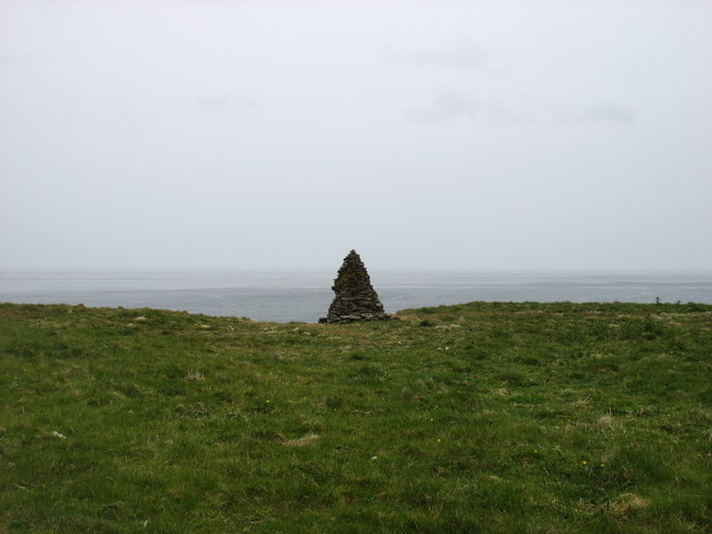
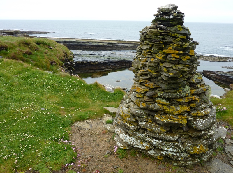
St Mary's Well Images

Images are sourced within 2km of 58.603/-3.678 or Grid Reference ND0269. Thanks to Geograph Open Source API. All images are credited.

Crosskirk, Caithness, disused Chapel
St Mary's - ruined chapel Crosskirk
Sea cliff Typical weathering of an 'Old Red Sandstone' sea cliff taken at low tide, showing the strata of the sandstone beds.
Sea cliff
Typical weathering of an 'Old Red Sandstone' sea cliff taken at low tide, showing the strata of the sandstone beds.
Forss: postbox № KW14 28 A small postbox serving the few premises at Bridge of Forss, emptied at 2:30 on weekday afternoons and 11:30 on Saturday mornings.
Forss: postbox № KW14 28
A small postbox serving the few premises at Bridge of Forss, emptied at 2:30 on weekday afternoons and 11:30 on Saturday mornings.
Tunnel of Trees
Tunnel of Trees
Track to St Mary's Chapel
St Mary's Chapel and graveyard The wind turbines are near the Forss Business and Technology Park, which lies in the square to the south.

"St Mary’s Chapel was probably built in the 1100s, though the religious significance of the site may date back further." [Historic Environment Scotland]
St Mary's Chapel and graveyard
The wind turbines are near the Forss Business and Technology Park, which lies in the square to the south. "St Mary’s Chapel was probably built in the 1100s, though the religious significance of the site may date back further." [Historic Environment Scotland]
Shore near St Mary's Chapel
Sheep near St Mary's Chapel The foreground sheep are in this grid square. The rest of the scene lies in the square to the south.
Sheep near St Mary's Chapel
The foreground sheep are in this grid square. The rest of the scene lies in the square to the south.
Sea Stack at Crosskirk A sea stack of sedimentary rock near Crosskirk Bay.
Sea Stack at Crosskirk
A sea stack of sedimentary rock near Crosskirk Bay.
Boundary wall Mains of Brims Farm
Cairn beside St Mary's chapel, Crosskirk Looking due north to a very calm Atlantic Ocean.
Cairn beside St Mary's chapel, Crosskirk
Looking due north to a very calm Atlantic Ocean.
Headland at Crosskirk Looking just east of north, from near the ruined chapel, to a very calm Atlantic Ocean.
Headland at Crosskirk
Looking just east of north, from near the ruined chapel, to a very calm Atlantic Ocean.
St Mary's chapel, Crosskirk This ruined chapel used to be accessible from the south. But now it can be reached only by a more awkward route from the east.
St Mary's chapel, Crosskirk
This ruined chapel used to be accessible from the south. But now it can be reached only by a more awkward route from the east.
Coastline below Forss Business and Energy Park, Caithness Accessing this grid square was easier than I was expecting due to a flagstone "staircase" in the cliff.  See <a href="https://www.geograph.org.uk/photo/6596119">ND0169 : Coastline below Forss Business and Energy Park, Caithness</a>.
Coastline below Forss Business and Energy Park, Caithness
Accessing this grid square was easier than I was expecting due to a flagstone "staircase" in the cliff. See ND0169 : Coastline below Forss Business and Energy Park, Caithness.
Cairn, Crosskirk, Caithness The cairn marks the site of a broch, some walling of which can be seen below it.  The broch was excavated by archaeologists between 1966 and 1972.  Most of it was then bulldozed over the cliff edge, apparently to prevent coastal erosion.  Hopefully an alternative solution would have been found nowadays.  Several hundred photos of the excavation are available via <span class="nowrap"><a title="https://canmore.org.uk/site/8019/crosskirk" rel="nofollow ugc noopener" href="https://canmore.org.uk/site/8019/crosskirk">Link</a><img style="margin-left:2px;" alt="External link" title="External link - shift click to open in new window" src="https://s1.geograph.org.uk/img/external.png" width="10" height="10"/></span>.
Cairn, Crosskirk, Caithness
The cairn marks the site of a broch, some walling of which can be seen below it. The broch was excavated by archaeologists between 1966 and 1972. Most of it was then bulldozed over the cliff edge, apparently to prevent coastal erosion. Hopefully an alternative solution would have been found nowadays. Several hundred photos of the excavation are available via LinkExternal link.
Ripple marked rock below below Forss Business and Energy Park, Caithness The ripples are fossilised sediment which was formed into ridges by the action of water or wind.
Ripple marked rock below below Forss Business and Energy Park, Caithness
The ripples are fossilised sediment which was formed into ridges by the action of water or wind.
Show me another place!

St Mary's Well is located at Grid Ref: ND0269 (Lat: 58.603, Lng: -3.678)

Unitary Authority: Highlands

Police Authority: Highland and Islands

What 3 Words

///spreading.lawful.scraper. Near Reay, Highland

Related Wikis

Crosskirk Broch

Crosskirk Broch was a fortification near the present day hamlet of Crosskirk near Thurso, Caithness, Scotland. After thorough archaeological exploration...

Crosskirk

Crosskirk is a small remote hamlet, overlooking Crosskirk Bay, in Caithness, Scottish Highlands and is in the Scottish council area of Highland.The hamlet...

Forss, Highland

Forss is a small hamlet, situated 3 miles west of Thurso, in Caithness, Scottish Highlands and is in the Scottish council area of Highland. Brims Castle...

Brims Castle

Brims Castle is a ruined 16th century L-plan tower house on Brims Ness, Highland region, Scotland, to the south of the Pentland Firth, about 5 miles (8...

Nearby Amenities

Located within 500m of 58.603,-3.678
Source: Bing
Lat/Long: 58.6066467/-3.6730994
Hill of Lybster
Ele: 52
Man Made: survey_point
Note Ele: 169 ft
Place: locality
Source: OS7
Source Ele: OS7
Source Name: OS7
Lat/Long: 58.6011946/-3.6835169
St Mary's Well
Man Made: water_well
Source: OS7
Source Name: OS7
Lat/Long: 58.6050401/-3.680942
Source: Bing
Lat/Long: 58.6056854/-3.672274
Source: Bing
Lat/Long: 58.6054761/-3.6714453
Source: Bing
Lat/Long: 58.6044947/-3.6714361
Source: Bing
Lat/Long: 58.6038575/-3.6716576
Source: Bing
Lat/Long: 58.6028226/-3.6709978
Generator Method: wind_turbine
Generator Output Electricity: yes
Generator Source: wind
Generator Type: horizontal_axis
Power: generator
Lat/Long: 58.603848/-3.6842486
Generator Method: wind_turbine
Generator Output Electricity: yes
Generator Source: wind
Generator Type: horizontal_axis
Power: generator
Lat/Long: 58.6017442/-3.6859454
Man Made: mast
Lat/Long: 58.6012306/-3.6836876
Power: pole
Lat/Long: 58.5987074/-3.6780113
Power: pole
Lat/Long: 58.6010658/-3.6829507
Power: pole
Lat/Long: 58.6005325/-3.6819126
Power: pole
Lat/Long: 58.6000143/-3.6808938
Power: pole
Lat/Long: 58.5997464/-3.6797543
Power: pole
Lat/Long: 58.5994961/-3.6785762
Power: pole
Lat/Long: 58.5991112/-3.6780354
Power: pole
Lat/Long: 58.5988647/-3.6777119
Power: pole
Lat/Long: 58.598559/-3.6772895
Power: pole
Lat/Long: 58.604227/-3.6699058
Power: pole
Lat/Long: 58.6035467/-3.6703572
Power: pole
Lat/Long: 58.6028486/-3.67077
Power: pole
Lat/Long: 58.6023632/-3.6710525
Power: pole
Lat/Long: 58.6019456/-3.6713518
Power: pole
Lat/Long: 58.6020814/-3.6722692
Power: pole
Lat/Long: 58.6022399/-3.6733508
Power: pole
Lat/Long: 58.6023833/-3.6744178
Power: pole
Lat/Long: 58.6025569/-3.6757939
Power: pole
Lat/Long: 58.6027254/-3.6770396
Power: pole
Lat/Long: 58.6029065/-3.6783336
Power: pole
Lat/Long: 58.6035479/-3.679082
Power: pole
Lat/Long: 58.604222/-3.6794538
Ford: yes
Lat/Long: 58.6057129/-3.6727906
The data included in this document is from www.openstreetmap.org. The data is made available under ODbL.

Have you been to St Mary's Well?

Leave your review of St Mary's Well below (or comments, questions and feedback).