St Leonard's Chapel

Heritage Site in Kent Tonbridge and Malling

England

St Leonard's Chapel

West Malling by-pass and cycle path A well designed cycle path beside the A228 just before the main entrance into the Kings Hill estate.
West Malling by-pass and cycle path Credit: Ron Lee

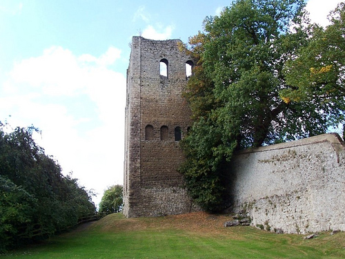
St Leonard's Chapel, located in the county of Kent, is a renowned heritage site that holds significant historical and architectural importance. This medieval chapel, believed to have been built in the late 12th century, stands in the picturesque village of Hythe, near the south-east coast of England.

The chapel is a stunning example of Romanesque architecture, characterized by its rounded arches, thick stone walls, and small windows. It is constructed from local flint and features a simple yet elegant design, typical of the era in which it was built.

One of the most notable features of St Leonard's Chapel is its well-preserved interior. The original medieval wall paintings, depicting scenes from the Bible, have survived the test of time and provide a fascinating glimpse into the religious and artistic practices of the period.

Additionally, the chapel is home to a beautifully carved Norman font, which is believed to be one of the oldest in the country. The font's intricate detailing and craftsmanship make it a true marvel to behold.

St Leonard's Chapel has played an important role in the local community for centuries. It has served as a place of worship, a meeting space, and even a school. Today, it continues to be used for religious ceremonies and is a popular tourist attraction, drawing visitors from far and wide who are captivated by its historical significance and architectural beauty.

As a designated heritage site, St Leonard's Chapel is carefully preserved and maintained by local authorities to ensure its historical and cultural value endures for future generations to appreciate and enjoy.

If you have any feedback on the listing, please let us know in the comments section below.

St Leonard's Chapel Images

Images are sourced within 2km of 51.282/0.402 or Grid Reference TQ6756. Thanks to Geograph Open Source API. All images are credited.

West Malling by-pass and cycle path A well designed cycle path beside the A228 just before the main entrance into the Kings Hill estate.
West Malling by-pass and cycle path
A well designed cycle path beside the A228 just before the main entrance into the Kings Hill estate.
Footpath through orchard from Broadwater Lane
Footpath through an orchard from Lavenders Lane to Broadwater road
Water Lane West Malling Just before its junction with the High Street
Water Lane West Malling
Just before its junction with the High Street
Swan Street, West Malling
Lobster Pot, West Malling
Police Station Road, West Malling
Swan Street, West Malling
High Street, West Malling
King Street, West Malling
Ryarsh Lane, West Malling
The Bull, West Malling
Town Hill, West Malling
Offham Road, West Malling
Norman Road, West Malling
Alma Road, West Malling
Norman Road, West Malling
Show me another place!

St Leonard's Chapel is located at Grid Ref: TQ6756 (Lat: 51.282, Lng: 0.402)

Administrative County: Kent

District: Tonbridge and Malling

Police Authority: Kent

What 3 Words

///balconies.princely.compiler. Near Kings Hill, Kent

Related Wikis

Manor Park Country Park

Manor Park Country Park is a country park in West Malling, Kent, England. The 52-acre (210,000 m2) park, formerly the private gardens of the nearby Douces...

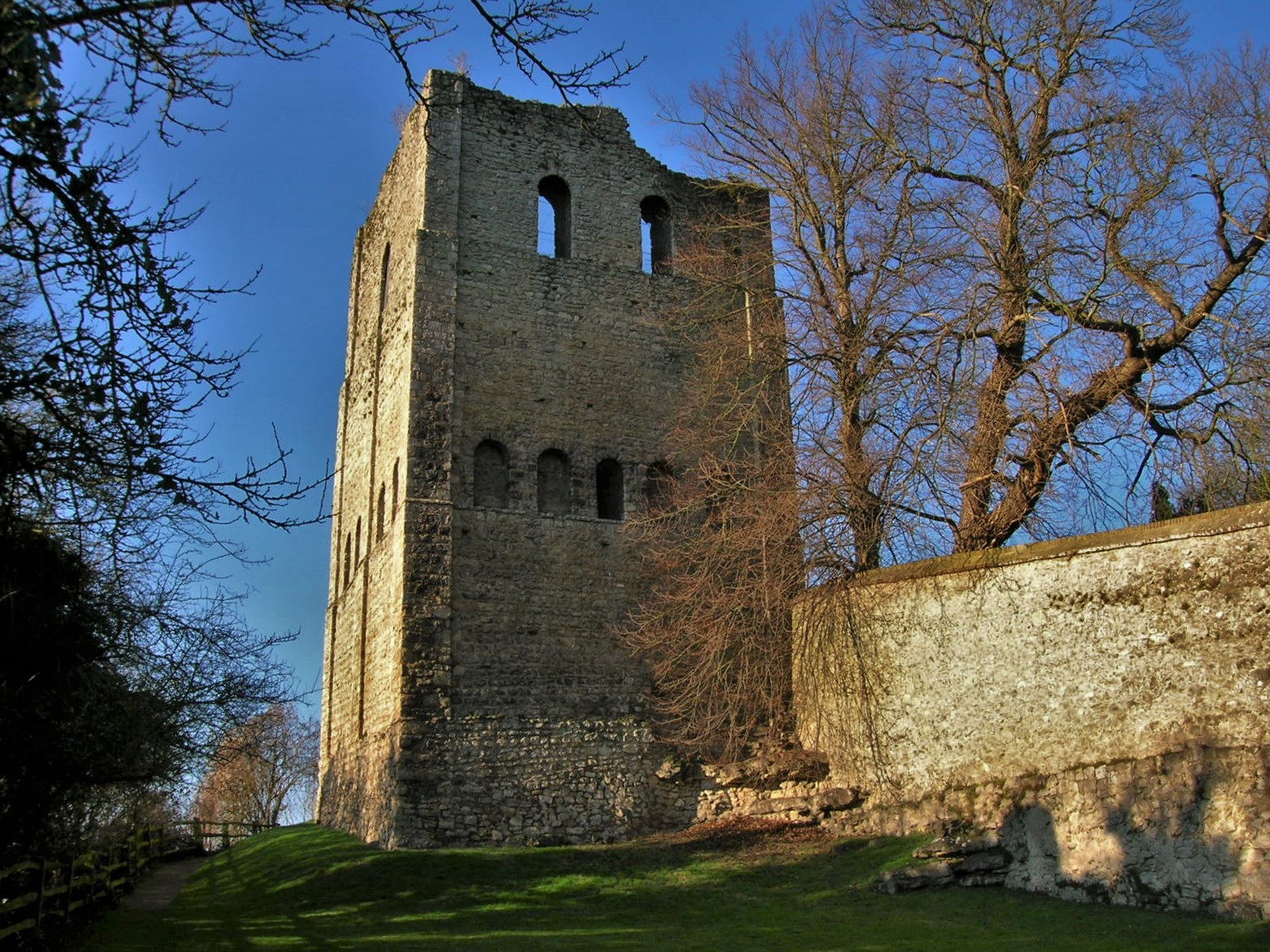
St Leonard's Tower, West Malling

St Leonard's Tower is a probable Norman keep in West Malling, in the county of Kent, England. The tower was probably built by Gundulf, the Bishop of Rochester...

Kings Hill

Kings Hill is a civil parish in the borough of Tonbridge and Malling in Kent, England. It is one of several new villages built in Kent since the 1950s...

RAF West Malling

Royal Air Force West Malling or more simply RAF West Malling is a former Royal Air Force station located 1.6 miles (2.6 km) south of West Malling, Kent...

Malling Rural District

Malling was a rural district in Kent, England which covered West Malling, East Malling, Snodland, Larkfield, Borough Green and Aylesford. From after the...

West Malling

West Malling ( MAW-ling, historically Town Malling) is a market town in the Tonbridge and Malling district of Kent, England. It has a population of 2,590...

Malling Abbey

St Mary's Abbey, also known as Malling Abbey, is an abbey of Anglican Benedictine nuns located in West Malling, Kent, England. It was founded around 1090...

St Augustine's College of Theology

St Augustine's College of Theology is a non-residential Anglican theological college in the Southeast of England. Founded in 1994 as the South East Institute...

Nearby Amenities

Located within 500m of 51.282,0.402
RDT Limited
Building: Capita Data Centre
Lat/Long: 51.2795544/0.3975201
Crossing
Bicycle: yes
Crossing: traffic_signals
Crossing Ref: toucan
Lat/Long: 51.2816918/0.4029211
Crossing
Bicycle: yes
Crossing: traffic_signals
Crossing Ref: toucan
Lat/Long: 51.2819643/0.4029988
Bus Stop
Kimberly Clark
Local Ref: adj
Naptan AtcoCode: 2400A000040A
Naptan Bearing: E
Naptan BusStopType: MKD
Naptan CommonName: Kimberly Clark
Naptan Indicator: adj
Naptan Landmark: Kimberly Clark
Naptan NaptanCode: kntadjgw
Naptan RevisionNumber: 6
Naptan Status: act
Naptan Street: Kings Hill Avenue
Naptan Verified: no
Public Transport: platform
Ref: kntadjgw
Shelter: yes
Source: naptan_import
Source Date: 2018-02-12
Lat/Long: 51.2777855/0.4013459
Bus Stop
Kimberly Clark
Local Ref: opp
Naptan AtcoCode: 2400A000050A
Naptan Bearing: W
Naptan BusStopType: MKD
Naptan CommonName: Kimberly Clark
Naptan Indicator: opp
Naptan Landmark: Kimberly Clark
Naptan NaptanCode: kntadjma
Naptan RevisionNumber: 4
Naptan Status: act
Naptan Street: Kings Hill Avenue
Naptan Verified: no
Public Transport: platform
Ref: kntadjma
Source: naptan_import
Source Date: 2018-02-12
Lat/Long: 51.277906/0.4001317
Bus Stop
King Hill
Bus: yes
Naptan AtcoCode: 2400A000130A
Naptan Bearing: S
Naptan CommonName: King Hill
Naptan Indicator: S-bound
Naptan Landmark: King Hill
Naptan NaptanCode: kntadjpd
Naptan Street: King Hill
Naptan Verified: no
Public Transport: platform
Source: naptan_import
Lat/Long: 51.2804556/0.3953056
Bus Stop
Tower View
Local Ref: S-bound
Naptan AtcoCode: 2400A074380A
Naptan Bearing: S
Naptan BusStopType: MKD
Naptan CommonName: Tower View
Naptan Indicator: S-bound
Naptan Landmark: Kings Hill Avenue Roundabout
Naptan NaptanCode: kntgjgtj
Naptan RevisionNumber: 4
Naptan Status: act
Naptan Street: Tower View
Naptan Verified: no
Public Transport: platform
Ref: kntgjgtj
Source: naptan_import
Source Date: 2018-02-12
Lat/Long: 51.2778452/0.4025798
Mini Roundabout
Direction: clockwise
Lat/Long: 51.2794215/0.404555
Mini Roundabout
Direction: clockwise
Lat/Long: 51.2808206/0.4058739
Addr City: West Malling
Addr Housename: 1 Tower View
Addr Postcode: ME19 4HA
Lat/Long: 51.2782322/0.4015682
Traffic Signals
Traffic Signals: signal
Traffic Signals Direction: forward
Lat/Long: 51.2817382/0.4029663
Traffic Signals
Traffic Signals: pedestrian_crossing
Traffic Signals Direction: forward
Lat/Long: 51.2819499/0.4029344
The Obelisk
Tourism: artwork
Lat/Long: 51.2811933/0.4025516
Noexit: yes
Lat/Long: 51.2776423/0.4030395
Traffic Calming: island
Lat/Long: 51.279493/0.4032634
Generator Method: photovoltaic
Generator Output Electricity: yes
Generator Source: solar
Generator Type: solar_photovoltaic_panel
Location: roof
Power: generator
Lat/Long: 51.2817562/0.3964171
Generator Method: photovoltaic
Generator Output Electricity: yes
Generator Source: solar
Generator Type: solar_photovoltaic_panel
Location: roof
Power: generator
Lat/Long: 51.2817353/0.396511
Generator Method: photovoltaic
Generator Output Electricity: yes
Generator Source: solar
Generator Type: solar_photovoltaic_panel
Location: roof
Power: generator
Lat/Long: 51.2845143/0.3986648
Noexit: yes
Lat/Long: 51.27824/0.405597
Noexit: yes
Lat/Long: 51.278687/0.4054663
Traffic Signals
Traffic Signals: signal
Traffic Signals Direction: forward
Lat/Long: 51.2816775/0.4027318
Bus Stop
Lat/Long: 51.2783202/0.4028785
The data included in this document is from www.openstreetmap.org. The data is made available under ODbL.

Have you been to St Leonard's Chapel?

Leave your review of St Leonard's Chapel below (or comments, questions and feedback).