Pen Beri and Treleidir

Heritage Site in Pembrokeshire

Wales

Pen Beri and Treleidir

Northwestern edge of Dowrog Common LNR Some of the invasive gorse and willow has been cleared and burnt by the Wildlife Trust. The boundary bank with bushes is on the right. Rhodiad-y-Brenin is on the skyline.
Northwestern edge of Dowrog Common LNR Credit: M J Roscoe

Pen Beri and Treleidir are two notable heritage sites located in Pembrokeshire, Wales. These sites are of historical and cultural significance, attracting visitors from around the world.

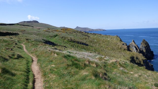
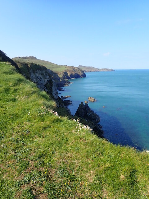
Pen Beri, also known as Penberry, is an ancient hillfort situated near the village of Roch. It dates back to the Iron Age and is believed to have been inhabited around 2,500 years ago. The hillfort consists of a double rampart and ditch system, enclosing an area of approximately 3.5 hectares. The site offers breathtaking views of the surrounding countryside and is a popular destination for hikers and history enthusiasts.

Treleidir, on the other hand, is an impressive Neolithic burial chamber located near the village of Trefin. This well-preserved chamber, also referred to as a cromlech or dolmen, consists of several large standing stones supporting a capstone, creating a structure resembling a giant stone table. Archaeological research suggests that Treleidir was built around 5,000 years ago, making it one of the oldest surviving structures in the region. It is believed to have been used as a communal burial site for the local community during the Neolithic period.

Both Pen Beri and Treleidir provide valuable insights into the lives and customs of ancient communities in Pembrokeshire. They serve as reminders of the region's rich historical past and contribute to our understanding of prehistoric societies. The sites are managed and protected by local authorities, ensuring their preservation for future generations to enjoy and learn from.

If you have any feedback on the listing, please let us know in the comments section below.

Pen Beri and Treleidir Images

Images are sourced within 2km of 51.916/-5.25 or Grid Reference SM7629. Thanks to Geograph Open Source API. All images are credited.

Northwestern edge of Dowrog Common LNR Some of the invasive gorse and willow has been cleared and burnt by the Wildlife Trust. The boundary bank with bushes is on the right. Rhodiad-y-Brenin is on the skyline.
Northwestern edge of Dowrog Common LNR
Some of the invasive gorse and willow has been cleared and burnt by the Wildlife Trust. The boundary bank with bushes is on the right. Rhodiad-y-Brenin is on the skyline.
Make Hay. Pwll-caerog, looking across the fields from the Pembrokeshire Coast Path.
Make Hay.
Pwll-caerog, looking across the fields from the Pembrokeshire Coast Path.
Porth Tre-wen
Porth Tre-wen
Stonechat The European Stonechat (Saxicola rubicola) breed in heathland, coastal dunes and rough grassland with scattered small shrubs and bramble, open gorse, tussocks or heather. The male's song is high and twittering like a Dunnock. Both sexes have a clicking call like stones knocking together.
Stonechat
The European Stonechat (Saxicola rubicola) breed in heathland, coastal dunes and rough grassland with scattered small shrubs and bramble, open gorse, tussocks or heather. The male's song is high and twittering like a Dunnock. Both sexes have a clicking call like stones knocking together.
Porth Tre-wen Taken from the coastal path
Porth Tre-wen
Taken from the coastal path
Castell Coch Fort
Castell Coch Fort
Ynys Gwair
Ynys Gwair
Thrift on a clifftop wall Clifftop field walls such as this are the classic place to find the coastal plant known as Thrift or Sea Pink.
Thrift on a clifftop wall
Clifftop field walls such as this are the classic place to find the coastal plant known as Thrift or Sea Pink.
Ynys Gwair and the Clifftop at Castell Coch Ynys Gwair is the offshore island with the much smaller Carreg-gwylan-fach just beyond.
Ynys Gwair and the Clifftop at Castell Coch
Ynys Gwair is the offshore island with the much smaller Carreg-gwylan-fach just beyond.
Ynys Gwair
Ynys Gwair
Coast Path Near Tremynydd Fawr Looking towards Penclegyr and the Bishops islet off Whitesands
Coast Path Near Tremynydd Fawr
Looking towards Penclegyr and the Bishops islet off Whitesands
Path Near Ynys Gwair Heading southwest
Path Near Ynys Gwair
Heading southwest
An Abundance Of Thrift Especially beautiful this year
An Abundance Of Thrift
Especially beautiful this year
Castell Coch Iron Age Promontory Fort
Pembrokeshire Coast Path Going west towards Aberdinas. The rocky hill ahead is Carn Penberry
Pembrokeshire Coast Path
Going west towards Aberdinas. The rocky hill ahead is Carn Penberry
Ynys Gwair and Carreg Gwylan Fach Two rocky islets at Aberdinas
Ynys Gwair and Carreg Gwylan Fach
Two rocky islets at Aberdinas
Aberdinas Inlet on the north Pembrokeshire coast
Aberdinas
Inlet on the north Pembrokeshire coast
Rugged Pembrokeshire Coast Looking down the coast, the shores mostly inaccessible from the clifftops. Penberry hill on the left and Carn Llidi in the distance
Rugged Pembrokeshire Coast
Looking down the coast, the shores mostly inaccessible from the clifftops. Penberry hill on the left and Carn Llidi in the distance
Show me another place!

Pen Beri and Treleidir is located at Grid Ref: SM7629 (Lat: 51.916, Lng: -5.25)

Unitary Authority: Pembrokeshire

Police Authority: Dyfed Powys

What 3 Words

///crispy.fictional.sunblock. Near St Davids, Pembrokeshire

Related Wikis

Dowrog Common

Dowrog Common (Welsh: Comin Dowrog) is a Site of Special Scientific Interest (or SSSI) in Pembrokeshire, South Wales. It has been designated as a Site...

Carn Llidi

Carn Llidi is a hill east of St David's Head in Pembrokeshire, Wales. Carn Llidi and its surrounding area is part of the Pembrokeshire Coast National Park...

Caerfarchell

Caerfarchell (Welsh pronunciation: [kaɪrvɑːrxɛɬ]) is a small village in Pembrokeshire, Wales, 3 miles northeast of St Davids, close by the A487 road. It...

Penrhiw Priory

Penrhiw Priory was originally built as a vicarage in St Davids, Pembrokeshire, Wales, in 1884. The building was enlarged in the 1960s, serving for a time...

Arfordir Abereiddi

Arfordir Abereiddi is a Site of Special Scientific Interest (SSSI) in Pembrokeshire, South Wales. It has been designated as a Site of Special Scientific...

Abereiddy

Abereiddy (Welsh: Abereddi) is a hamlet in the county of Pembrokeshire, in west Wales.It has a small beach which was awarded the Blue flag rural beach...

Ysgol Dewi Sant

Ysgol Dewi Sant is a secondary school in St Davids, Pembrokeshire, Wales. == Description == The school serves the historic city of St Davids and an extensive...

St David's (Pembrokeshire electoral ward)

St David's is the name of an electoral ward in Pembrokeshire, Wales. It covers the small city of St Davids and the ward's boundaries are coterminous with...

Nearby Amenities

Located within 500m of 51.916,-5.25
Penbiri
Natural: peak
Lat/Long: 51.9165222/-5.2492449
Power: pole
Lat/Long: 51.91572/-5.2434638
Power: pole
Lat/Long: 51.9149027/-5.2436945
Power: pole
Lat/Long: 51.9140208/-5.2439332
Power: pole
Lat/Long: 51.9134335/-5.2441156
Direction: SSE
Generator Method: photovoltaic
Generator Output Electricity: yes
Generator Solar Modules: 14
Generator Source: solar
Generator Type: solar_photovoltaic_panel
Location: roof
Power: generator
Lat/Long: 51.9147372/-5.2444837
The data included in this document is from www.openstreetmap.org. The data is made available under ODbL.

Have you been to Pen Beri and Treleidir?

Leave your review of Pen Beri and Treleidir below (or comments, questions and feedback).