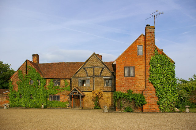
Ockwells Manor

Heritage Site in Berkshire

England

Ockwells Manor

Braywick Cemetery: early February 2022
Braywick Cemetery: early February 2022 Credit: Basher Eyre

Ockwells Manor, located in Berkshire, England, is a historic heritage site that dates back to the 15th century. This magnificent manor house is known for its exceptional architectural features and is considered a prime example of late medieval design.

The manor is built in a traditional timber-framed style, with intricate carved details and a stunning red brick exterior. Its picturesque setting amidst beautifully landscaped gardens and rolling countryside adds to its charm and appeal. Ockwells Manor is a Grade I listed building, which means it is recognized as being of exceptional historical and architectural significance.

Inside the manor, visitors can explore the various rooms that have been painstakingly preserved over the centuries. The Great Hall, with its high timbered ceiling and impressive fireplace, is a highlight of the house. Other notable features include the Tudor-style decorated ceilings, the exquisite stained glass windows, and the ornate wooden staircase.

Ockwells Manor has been in the ownership of the same family for over 500 years, further adding to its rich history. The manor house is open to the public during certain times of the year, allowing visitors to experience firsthand the grandeur and authenticity of this medieval gem.

Overall, Ockwells Manor in Berkshire is a captivating heritage site that offers a glimpse into the past. Its architectural beauty, historical significance, and well-preserved features make it a must-visit destination for history enthusiasts and architecture aficionados alike.

If you have any feedback on the listing, please let us know in the comments section below.

Ockwells Manor Images

Images are sourced within 2km of 51.502/-0.739 or Grid Reference SU8778. Thanks to Geograph Open Source API. All images are credited.

Braywick Cemetery: early February 2022
Mid section of Ockwells Road
Brayswick Cemetery: path
The Holyport Interchange Junction 8/9 on the M4, where it links with the A404(M) and the A308(M), viewed from a plane approaching Heathrow Airport.
The Holyport Interchange
Junction 8/9 on the M4, where it links with the A404(M) and the A308(M), viewed from a plane approaching Heathrow Airport.
Willant Close, Woodlands Park, White Waltham The western edge of the built up area with the bungalows on the left backing onto the airfield.
Willant Close, Woodlands Park, White Waltham
The western edge of the built up area with the bungalows on the left backing onto the airfield.
Holyport : M4 Motorway Approaching Holyport Interchange.
Holyport : M4 Motorway
Approaching Holyport Interchange.
Cox Green : M4 Motorway Looking along the M4 Motorway eastbound.
Cox Green : M4 Motorway
Looking along the M4 Motorway eastbound.
Farmland, Cox Green A footpath between arable fields to the south of Woodlands Park.
Farmland, Cox Green
A footpath between arable fields to the south of Woodlands Park.
J9a, A404(M) The A404(M) is 2 miles long and is called the Maidenhead bypass, and is one of two motorways to meet the M4 at the double numbered J8/9.
J9a, A404(M)
The A404(M) is 2 miles long and is called the Maidenhead bypass, and is one of two motorways to meet the M4 at the double numbered J8/9.
J9a, A404(M) The A404(M) is 2 miles long and is called the Maidenhead bypass, and is one of two motorways to meet the M4 at the double numbered J8/9.
J9a, A404(M)
The A404(M) is 2 miles long and is called the Maidenhead bypass, and is one of two motorways to meet the M4 at the double numbered J8/9.
A404(M) approaching J8 The A404(M) is 2 miles long and is called the Maidenhead bypass, and is one of two motorways to meet the M4 at the double numbered J8/9.
A404(M) approaching J8
The A404(M) is 2 miles long and is called the Maidenhead bypass, and is one of two motorways to meet the M4 at the double numbered J8/9.
Footbridge over the M4 The M4 is 190 miles long and runs from London to South Wales. Major centres close to the motorway include Reading, Swindon, Bristol, Newport, Cardiff and Swansea. The motorway was constructed between 1961 and 1996. The M4 originally crossed the first Severn Road Bridge. It has now been diverted to use the Second Severn Crossing and the motorway over the older bridge has been renumbered as M48.
Wikipedia: <span class="nowrap"><a title="http://en.wikipedia.org/wiki/M4_motorway" rel="nofollow ugc noopener" href="http://en.wikipedia.org/wiki/M4_motorway">Link</a><img style="margin-left:2px;" alt="External link" title="External link - shift click to open in new window" src="https://s1.geograph.org.uk/img/external.png" width="10" height="10"/></span>
Footbridge over the M4
The M4 is 190 miles long and runs from London to South Wales. Major centres close to the motorway include Reading, Swindon, Bristol, Newport, Cardiff and Swansea. The motorway was constructed between 1961 and 1996. The M4 originally crossed the first Severn Road Bridge. It has now been diverted to use the Second Severn Crossing and the motorway over the older bridge has been renumbered as M48. Wikipedia: LinkExternal link
M4, westbound The M4 is 190 miles long and runs from London to South Wales. Major centres close to the motorway include Reading, Swindon, Bristol, Newport, Cardiff and Swansea. The motorway was constructed between 1961 and 1996. The M4 originally crossed the first Severn Road Bridge. It has now been diverted to use the Second Severn Crossing and the motorway over the older bridge has been renumbered as M48.
Wikipedia: <span class="nowrap"><a title="http://en.wikipedia.org/wiki/M4_motorway" rel="nofollow ugc noopener" href="http://en.wikipedia.org/wiki/M4_motorway">Link</a><img style="margin-left:2px;" alt="External link" title="External link - shift click to open in new window" src="https://s1.geograph.org.uk/img/external.png" width="10" height="10"/></span>
M4, westbound
The M4 is 190 miles long and runs from London to South Wales. Major centres close to the motorway include Reading, Swindon, Bristol, Newport, Cardiff and Swansea. The motorway was constructed between 1961 and 1996. The M4 originally crossed the first Severn Road Bridge. It has now been diverted to use the Second Severn Crossing and the motorway over the older bridge has been renumbered as M48. Wikipedia: LinkExternal link
M4 footbridge The M4 is 190 miles long and runs from London to South Wales. Major centres close to the motorway include Reading, Swindon, Bristol, Newport, Cardiff and Swansea. The motorway was constructed between 1961 and 1996. The M4 originally crossed the first Severn Road Bridge. It has now been diverted to use the Second Severn Crossing and the motorway over the older bridge has been renumbered as M48.
Wikipedia: <span class="nowrap"><a title="http://en.wikipedia.org/wiki/M4_motorway" rel="nofollow ugc noopener" href="http://en.wikipedia.org/wiki/M4_motorway">Link</a><img style="margin-left:2px;" alt="External link" title="External link - shift click to open in new window" src="https://s1.geograph.org.uk/img/external.png" width="10" height="10"/></span>
M4 footbridge
The M4 is 190 miles long and runs from London to South Wales. Major centres close to the motorway include Reading, Swindon, Bristol, Newport, Cardiff and Swansea. The motorway was constructed between 1961 and 1996. The M4 originally crossed the first Severn Road Bridge. It has now been diverted to use the Second Severn Crossing and the motorway over the older bridge has been renumbered as M48. Wikipedia: LinkExternal link
Lillibrooke Manor Court Yard
Ockwells Park Fields
A404(M) Footbridge
A404(M) Footbridge
End of Ockwells Road - Cox Green
Show me another place!

Ockwells Manor is located at Grid Ref: SU8778 (Lat: 51.502, Lng: -0.739)

Unitary Authority: Windsor and Maidenhead

Police Authority: Thames Valley

What 3 Words

///free.love.alone. Near Maidenhead, Berkshire

Related Wikis

Ockwells

Ockwells Manor is a 13,838 sq ft (1,285.6 m2) timber-framed 15th century manor house in the civil parish of Cox Green, adjoining Maidenhead, in the English...

Ockwells Park

Ockwells Park is a park, part of which is a local nature reserve, in Cox Green, Berkshire, England. The nature reserve is owned by the Royal Borough of...

Cox Green, Berkshire

Cox Green is a civil parish in the Royal Borough of Windsor and Maidenhead in Berkshire. It is a large suburb of Maidenhead with most of its housing west...

Boyn Hill

Boyn Hill is a suburb of Maidenhead in the English county of Berkshire. It is located west of the town centre, between the A4 and the railway. == References ==

Nearby Amenities

Located within 500m of 51.502,-0.739
Bus Stop
Brill Close
Bus: yes
Naptan AtcoCode: 036006023023
Naptan Bearing: NE
Naptan CommonName: Brill Close
Naptan Indicator: adj
Naptan Landmark: Cox Green Road
Naptan NaptanCode: winatwa
Naptan PlusbusZoneRef: MDNHEAD
Naptan Street: Shoppenhangers Road
Naptan Verified: no
Public Transport: platform
Shelter: yes
Source: naptan_import
Lat/Long: 51.5059039/-0.7382462
Bus Stop
Brill Close
Naptan AtcoCode: 036006023024
Naptan Bearing: SW
Naptan CommonName: Brill Close
Naptan Indicator: opp
Naptan Landmark: Cox Green Road
Naptan NaptanCode: winatwd
Naptan PlusbusZoneRef: MDNHEAD
Naptan Street: Shoppenhangers Road
Naptan Verified: no
Source: naptan_import
Lat/Long: 51.5057345/-0.7383805
Bus Stop
Cox Green Road
Naptan AtcoCode: 036006733733
Naptan Bearing: SE
Naptan CommonName: Cox Green Road
Naptan Indicator: S-bound
Naptan Landmark: Lambourne Drive
Naptan NaptanCode: windwaw
Naptan PlusbusZoneRef: MDNHEAD
Naptan Street: Cox Green Road
Naptan Verified: no
Source: naptan_import
Lat/Long: 51.5063619/-0.7398618
Mini Roundabout
Direction: clockwise
Lat/Long: 51.5060685/-0.7377733
Traffic Calming: cushion
Lat/Long: 51.5061626/-0.7397456
Direction: 250
Fixme: survey for panel count
Generator Method: photovoltaic
Generator Output Electricity: yes
Generator Solar Modules: 8
Generator Source: solar
Generator Type: solar_photovoltaic_panel
Location: roof
Power: generator
Lat/Long: 51.5053646/-0.7423778
Direction: 70
Fixme: survey for panel count
Generator Method: photovoltaic
Generator Output Electricity: yes
Generator Solar Modules: 8
Generator Source: solar
Generator Type: solar_photovoltaic_panel
Location: roof
Power: generator
Lat/Long: 51.5053765/-0.7423267
Direction: 250
Fire Hydrant Type: survey for panel count
Fixme: survey for panel count
Generator Method: photovoltaic
Generator Output Electricity: yes
Generator Solar Modules: 16
Generator Source: solar
Generator Type: solar_photovoltaic_panel
Location: roof
Power: generator
Lat/Long: 51.5050461/-0.7422067
Direction: 270
Generator Method: photovoltaic
Generator Output Electricity: yes
Generator Solar Modules: 10
Generator Source: solar
Generator Type: solar_photovoltaic_panel
Location: roof
Power: generator
Lat/Long: 51.5050316/-0.7429306
Direction: 190
Fixme: survey for panel count
Generator Method: photovoltaic
Generator Output Electricity: yes
Generator Solar Modules: 15
Generator Source: solar
Generator Type: solar_photovoltaic_panel
Location: roof
Power: generator
Lat/Long: 51.5037181/-0.7450823
Direction: 180
Fixme: survey for panel count
Generator Method: photovoltaic
Generator Output Electricity: yes
Generator Solar Modules: 17
Generator Source: solar
Generator Type: solar_photovoltaic_panel
Location: roof
Power: generator
Lat/Long: 51.5037684/-0.7452867
Direction: 80
Generator Method: photovoltaic
Generator Output Electricity: yes
Generator Solar Modules: 10
Generator Source: solar
Generator Type: solar_photovoltaic_panel
Location: roof
Power: generator
Lat/Long: 51.5054474/-0.7360461
Direction: 260
Generator Method: photovoltaic
Generator Output Electricity: yes
Generator Solar Modules: 10
Generator Source: solar
Generator Type: solar_photovoltaic_panel
Location: roof
Power: generator
Lat/Long: 51.5054434/-0.7360977
Direction: 220
Generator Method: photovoltaic
Generator Output Electricity: yes
Generator Solar Modules: 18
Generator Source: solar
Generator Type: solar_photovoltaic_panel
Location: roof
Power: generator
Lat/Long: 51.5044833/-0.7332223
Direction: 220
Generator Method: photovoltaic
Generator Output Electricity: yes
Generator Solar Modules: 24
Generator Source: solar
Generator Type: solar_photovoltaic_panel
Location: roof
Power: generator
Lat/Long: 51.5041363/-0.7373605
Leisure: fitness_station
Sport: fitness
Lat/Long: 51.5014731/-0.7344645
Leisure: fitness_station
Sport: fitness
Lat/Long: 51.5020398/-0.7361719
Leisure: fitness_station
Sport: fitness
Lat/Long: 51.5021602/-0.7362075
Leisure: fitness_station
Sport: fitness
Lat/Long: 51.501374/-0.7359644
Leisure: fitness_station
Sport: fitness
Lat/Long: 51.5013937/-0.7355868
Access: private
Historic: aircraft
Inscription: Hawker Hunter T.Mk.7, 8836M / 41H/693743 XL592
Lat/Long: 51.5005825/-0.7382456
The data included in this document is from www.openstreetmap.org. The data is made available under ODbL.

Have you been to Ockwells Manor?

Leave your review of Ockwells Manor below (or comments, questions and feedback).