Mare & Foal

Heritage Site in Northumberland

England

Mare & Foal

Winshields Trigpoint, Highest point on Hadrian's Wall TP7000 - Winshields <span class="nowrap"><a title="http://trigpointing.uk/trig/7000" rel="nofollow ugc noopener" href="http://trigpointing.uk/trig/7000">Link</a><img style="margin-left:2px;" alt="External link" title="External link - shift click to open in new window" src="https://s1.geograph.org.uk/img/external.png" width="10" height="10"/></span>
Winshields Trigpoint, Highest point on Hadrian's Wall Credit: Brian Deegan

Mare & Foal, located in Northumberland, is a renowned heritage site that captivates visitors with its natural beauty and historical significance. Nestled within the picturesque landscape of the Northumberland National Park, this site offers a unique glimpse into the region's rich cultural heritage.

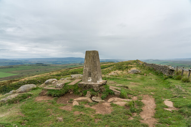
The highlight of Mare & Foal is the striking rock formation that resembles a mare and her foal, hence its name. This natural wonder has been shaped by millions of years of geological activity, resulting in a distinctive silhouette that is a sight to behold. Standing at approximately 50 feet tall, the rock formation is an iconic symbol of the Northumberland countryside.

In addition to its geological significance, Mare & Foal holds historical importance as well. The site is believed to have been used as a marker for ancient routes through the region, serving as a guide for travelers and drovers alike. It has also been associated with folklore and local legends, adding to its mystique and allure.

Visitors to Mare & Foal can enjoy scenic walks and hikes in the surrounding area, immersing themselves in the natural beauty of the Northumberland landscape. The site offers breathtaking views of rolling hills, lush meadows, and the nearby Simonside Hills, making it a haven for nature enthusiasts and photographers.

Overall, Mare & Foal in Northumberland is a must-visit heritage site for those seeking a blend of natural beauty and historical significance. Its distinctive rock formation, coupled with its stunning surroundings, creates an unforgettable experience that showcases the region's unique charm.

If you have any feedback on the listing, please let us know in the comments section below.

Mare & Foal Images

Images are sourced within 2km of 54.992/-2.43 or Grid Reference NY7266. Thanks to Geograph Open Source API. All images are credited.

Winshields Trigpoint, Highest point on Hadrian's Wall TP7000 - Winshields <span class="nowrap"><a title="http://trigpointing.uk/trig/7000" rel="nofollow ugc noopener" href="http://trigpointing.uk/trig/7000">Link</a><img style="margin-left:2px;" alt="External link" title="External link - shift click to open in new window" src="https://s1.geograph.org.uk/img/external.png" width="10" height="10"/></span>
Winshields Trigpoint, Highest point on Hadrian's Wall
TP7000 - Winshields LinkExternal link
Cawfields Milecastle (42) on Hadrian's Wall Hadrian's wall or 'Vallum Aelium' is the remains of a large Roman fortification. The wall extended west from Segedunum at Wallsend on the River Tyne to the shore of the Solway Firth, ending a short but unknown distance west of the village of Bowness-on-Solway. Construction probably started sometime in AD 122 and was largely completed within six years.

The remains were made a UNESCO World Heritage Site in 1987.
Cawfields Milecastle (42) on Hadrian's Wall
Hadrian's wall or 'Vallum Aelium' is the remains of a large Roman fortification. The wall extended west from Segedunum at Wallsend on the River Tyne to the shore of the Solway Firth, ending a short but unknown distance west of the village of Bowness-on-Solway. Construction probably started sometime in AD 122 and was largely completed within six years. The remains were made a UNESCO World Heritage Site in 1987.
Hadrian's Wall Vallum at Cawfields Hadrian's wall or 'Vallum Aelium' is the remains of a large Roman fortification. The wall extended west from Segedunum at Wallsend on the River Tyne to the shore of the Solway Firth, ending a short but unknown distance west of the village of Bowness-on-Solway. Construction probably started sometime in AD 122 and was largely completed within six years.

The remains were made a UNESCO World Heritage Site in 1987.
Hadrian's Wall Vallum at Cawfields
Hadrian's wall or 'Vallum Aelium' is the remains of a large Roman fortification. The wall extended west from Segedunum at Wallsend on the River Tyne to the shore of the Solway Firth, ending a short but unknown distance west of the village of Bowness-on-Solway. Construction probably started sometime in AD 122 and was largely completed within six years. The remains were made a UNESCO World Heritage Site in 1987.
Turret 41a on Hadrian's Wall at Caw Gap Hadrian's wall or 'Vallum Aelium' is the remains of a large Roman fortification. The wall extended west from Segedunum at Wallsend on the River Tyne to the shore of the Solway Firth, ending a short but unknown distance west of the village of Bowness-on-Solway. Construction probably started sometime in AD 122 and was largely completed within six years.

The remains were made a UNESCO World Heritage Site in 1987.
Turret 41a on Hadrian's Wall at Caw Gap
Hadrian's wall or 'Vallum Aelium' is the remains of a large Roman fortification. The wall extended west from Segedunum at Wallsend on the River Tyne to the shore of the Solway Firth, ending a short but unknown distance west of the village of Bowness-on-Solway. Construction probably started sometime in AD 122 and was largely completed within six years. The remains were made a UNESCO World Heritage Site in 1987.
Hadrian's Wall at Thorny Doors Hadrian's wall or 'Vallum Aelium' is the remains of a large Roman fortification. The wall extended west from Segedunum at Wallsend on the River Tyne to the shore of the Solway Firth, ending a short but unknown distance west of the village of Bowness-on-Solway. Construction probably started sometime in AD 122 and was largely completed within six years.

The remains were made a UNESCO World Heritage Site in 1987.
Hadrian's Wall at Thorny Doors
Hadrian's wall or 'Vallum Aelium' is the remains of a large Roman fortification. The wall extended west from Segedunum at Wallsend on the River Tyne to the shore of the Solway Firth, ending a short but unknown distance west of the village of Bowness-on-Solway. Construction probably started sometime in AD 122 and was largely completed within six years. The remains were made a UNESCO World Heritage Site in 1987.
Hadrian's Wall The Roman wall itself is under the bank to the left of the field wall.
Hadrian's Wall
The Roman wall itself is under the bank to the left of the field wall.
Milecastle 41 on Hadrian's Wall View from east.
Milecastle 41 on Hadrian's Wall
View from east.
Hadrian’s Wall at Winshield Crags
Windshields Trig Point At 345m this is the highest point on Hadrian’s Wall.
Windshields Trig Point
At 345m this is the highest point on Hadrian’s Wall.
Flush bracket on Winshields Trig Point
Hadrian’s Wall Path at Boogle Hole
Hadrian’s Wall at Caw Gap
Hadrian’s Wall: Turret 41A
Hadrian’s Wall at Thorny Doors
Cawfields Quarry
Cawfields Quarry
Caw Burn
Caw Burn
Hadrian’s Wall: Milecastle 42
Hadrian’s Wall at Cawfields Quarry
Show me another place!

Mare & Foal is located at Grid Ref: NY7266 (Lat: 54.992, Lng: -2.43)

What 3 Words

///fixture.instilled.buzzards. Near Haltwhistle, Northumberland

Nearby Locations

Mare & Foal

Related Wikis

Milecastle 41

Milecastle 41 (Melkridge) was a milecastle on Hadrian's Wall (grid reference NY73026705). == Description == Milecastle 41 is located to the east of Caw...

Milecastle 42

Milecastle 42 (Cawfields) is a milecastle on Hadrian's Wall (grid reference NY7157466692). == Description == Milecastle 42 is on a steep south-facing slope...
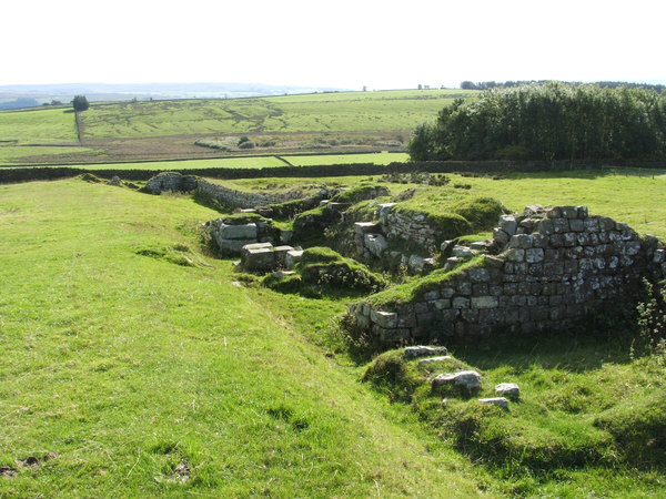
Aesica

Aesica (with the modern name of Great Chesters) was a Roman fort, one and a half miles north of the small town of Haltwhistle in Northumberland, England...

Lees Hall Roman Camp

Lees Hall Roman Camp is an archaeological site, a Roman camp near Hadrian's Wall, in Northumberland, England. It is near Haltwhistle and adjacent to the...

Nearby Amenities

Located within 500m of 54.992,-2.43
Barrier: stile
Lat/Long: 54.9892961/-2.4357821
Caw Gap
Natural: saddle
Lat/Long: 54.9957431/-2.4283731
Barrier: stile
Source: Bing
Lat/Long: 54.9952886/-2.4278131
Barrier: stile
Source: Bing
Lat/Long: 54.9953096/-2.4279904
Barrier: kissing_gate
Source: Bing
Lat/Long: 54.9957363/-2.4280604
Barrier: kissing_gate
Source: Bing
Lat/Long: 54.9956919/-2.4281832
Barrier: stile
Lat/Long: 54.9951045/-2.429634
Barrier: stile
Source: Bing
Lat/Long: 54.9940019/-2.4292463
Mare and Foal
Archaeological Site: megalith
Historic: archaeological_site
Megalith Type: menhir
Note: Doesn't seem to be much info on this. Some however suggest it may not be that old or a standing stone in the usual definition.
Source: Bing
Wikidata: Q17675109
Lat/Long: 54.9908315/-2.4307866
Board Type: history
Image: https://www.geograph.org.uk/photo/7543041
Information: board
Tourism: information
Lat/Long: 54.9957934/-2.4305856
The data included in this document is from www.openstreetmap.org. The data is made available under ODbL.

Have you been to Mare & Foal?

Leave your review of Mare & Foal below (or comments, questions and feedback).