Malthouse

Heritage Site in Kent

England

Malthouse

Entrance to Lynsted Park Viewed from Tickham Lane.
Entrance to Lynsted Park Credit: pam fray

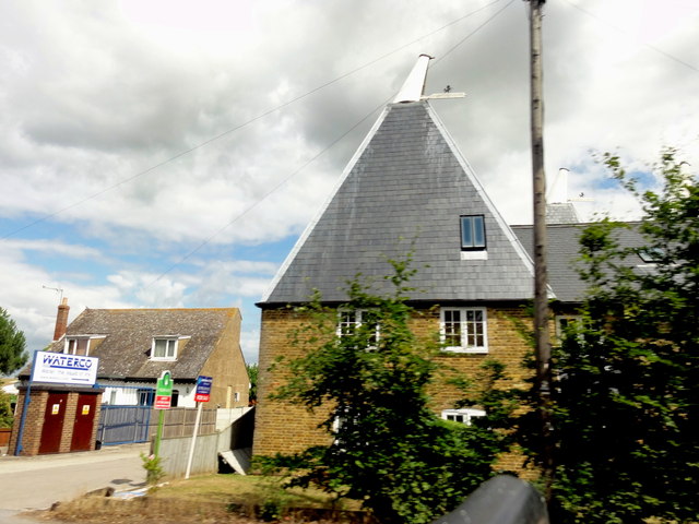
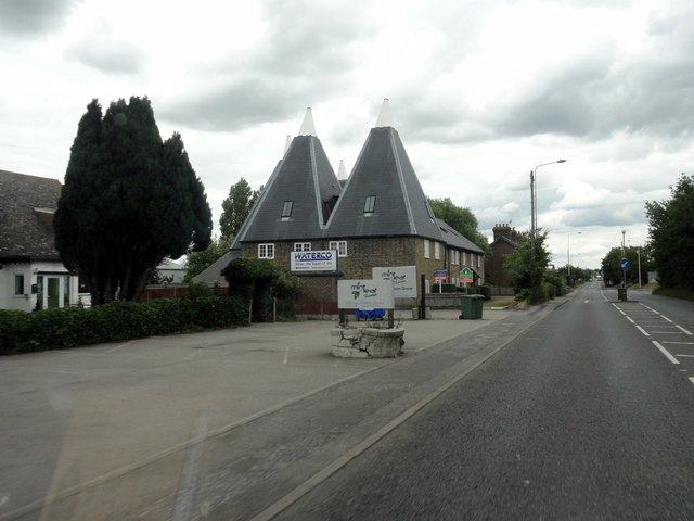
Malthouse, Kent is a historically significant heritage site located in the county of Kent, England. This site has a rich history dating back to the 18th century and is renowned for its well-preserved malthouse, which played a crucial role in the brewing industry during that time.

The malthouse itself is a remarkable structure made of red brick with a distinctive chimney stack. It was originally built in the mid-1700s and served as a malting facility, where barley was germinated and processed to produce malt. Malthouse, Kent was strategically situated near a water source, allowing for the malting process to be carried out efficiently.

Visitors to Malthouse, Kent can explore the various rooms and chambers within the malthouse, which provide an insight into the brewing techniques employed during the 18th century. The site also features displays of traditional brewing equipment and tools, giving visitors a glimpse into the craftsmanship and ingenuity of the era.

Additionally, Malthouse, Kent offers guided tours, where knowledgeable guides provide historical context and share fascinating anecdotes about the site's past. These tours allow visitors to learn about the significance of the malthouse in the local community and its role in shaping the brewing industry in Kent.

Malthouse, Kent is not only a testament to the industrial heritage of the region but also serves as a hub for education and cultural enrichment. It offers a unique opportunity to explore the history of brewing in Kent and its impact on the local economy.

If you have any feedback on the listing, please let us know in the comments section below.
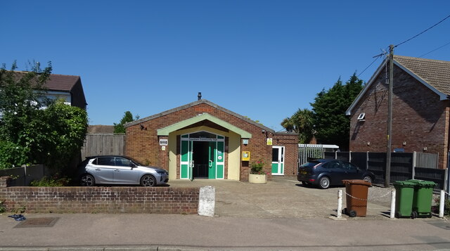
Malthouse Images

Images are sourced within 2km of 51.318/0.792 or Grid Reference TQ9461. Thanks to Geograph Open Source API. All images are credited.

Entrance to Lynsted Park Viewed from Tickham Lane.
Entrance to Lynsted Park
Viewed from Tickham Lane.
Dully House, Tonge, near Sittingbourne On Dully Road.
Dully House, Tonge, near Sittingbourne
On Dully Road.
View across Bapchild and The Swale to the Isle of Sheppey From a footpath running between Dully Road and Church Street, Rodmersham.
View across Bapchild and The Swale to the Isle of Sheppey
From a footpath running between Dully Road and Church Street, Rodmersham.
Elizabeth II postbox on Station Road, Teynham Postbox No. ME9 12.
Elizabeth II postbox on Station Road, Teynham
Postbox No. ME9 12.
Houses on Lower Road, Teynham
Lower Road, Teynham
Lower Road, Teynham
Houses on Station Road, Teynham
Station Road, Teynham
Teynham Community Hall On Station Road.
Teynham Community Hall
On Station Road.
Tickham Lane, Lynsted
Teynham - 2015 Teynham, Kent, London Road, A2
Teynham - 2015
Teynham, Kent, London Road, A2
Radfield - 2015 Radfield, Kent, London Road, A2
Radfield - 2015
Radfield, Kent, London Road, A2
Radfield - 2015 Radfield, Kent, London Road, A2
Radfield - 2015
Radfield, Kent, London Road, A2
Radfield - 2015 Radfield, Kent, London Road, A2
Radfield - 2015
Radfield, Kent, London Road, A2
Upper Newlands - 2015 Upper Newlands, Kent, London Road, A2, Oast Cottage
Upper Newlands - 2015
Upper Newlands, Kent, London Road, A2, Oast Cottage
The Old Vicarage, near Bapchild A Georgian house on Dully Road.
The Old Vicarage, near Bapchild
A Georgian house on Dully Road.
Footpath to Panteny Lane, near Bapchild Next to Haywood off Dully Road.
Footpath to Panteny Lane, near Bapchild
Next to Haywood off Dully Road.
Show me another place!

Malthouse is located at Grid Ref: TQ9461 (Lat: 51.318, Lng: 0.792)

Police Authority: Kent

What 3 Words

///storyline.manages.marine. Near Teynham, Kent

Nearby Locations

Malthouse Bogle Sunderland

Related Wikis

Lynsted

Lynsted is a village in Lynsted with Kingsdown civil parish in the Swale borough of Kent, England. The village is situated south of the A2 road between...

Teynham

Teynham ( TEN-əm) is a large village and civil parish in the borough of Swale in Kent, England. The parish lies between the towns of Sittingbourne and...

Lewson Street

Lewson Street is a village near the A2 road, in the Swale District, in the English county of Kent. It is near the towns of Sittingbourne and Faversham...

Bapchild

Bapchild is a village and civil parish in the Swale district of Kent, England, about two miles inside of Sittingbourne. It lies on the old Roman road...

Norton, Buckland and Stone

Norton, Buckland and Stone is a small rural civil parish 1 mile (1.6 km) east of Teynham and 3 miles (4.8 km) west of the centre of Faversham in the borough...

Teynham railway station

Teynham railway station is on the Chatham Main Line in England, serving the village of Teynham, Kent. It is 47 miles 74 chains (77.1 km) down the line...

Rodmersham

Rodmersham is a village and civil parish in the Borough of Swale in the north of the English county of Kent. It is just under 1 mile (1.6 km) south of...

Newbury, Kent

Newbury is a hamlet near the village of Erriottwood, in the Swale district, in the English county of Kent. It is near the town of Sittingbourne. ��2�...

Nearby Amenities

Located within 500m of 51.318,0.792
Batteries
Place: locality
Source: npe
Lat/Long: 51.3176591/0.7848966
Bus Stop
Lynsted & Norton Primary School
Bus: yes
Flag: no
Naptan AtcoCode: 2400A011490A
Naptan Bearing: W
Naptan BusStopType: CUS
Naptan CommonName: Lynsted & Norton Primary School
Naptan Indicator: adj
Naptan Landmark: Lynsted & Norton Primary School
Naptan NaptanCode: kntampta
Naptan Street: Lynsted Lane
Naptan Verified: no
Public Transport: platform
Source: naptan_import
Lat/Long: 51.3159477/0.7887215
Bus Stop
Lynsted & Norton Primary School
Bus: yes
Flag: no
Naptan AtcoCode: 2400A011500A
Naptan Bearing: E
Naptan BusStopType: CUS
Naptan CommonName: Lynsted & Norton Primary School
Naptan Indicator: opp
Naptan Landmark: Lynsted & Norton Primary School
Naptan NaptanCode: kntamptd
Naptan Street: Lynsted Lane
Naptan Verified: no
Public Transport: platform
Source: naptan_import
Lat/Long: 51.3160828/0.7887153
Bus Stop
Lynsted & Norton School
Bus: yes
Flag: no
Naptan AtcoCode: 2400A071870A
Naptan Bearing: W
Naptan BusStopType: CUS
Naptan CommonName: Lynsted & Norton School
Naptan Indicator: o/s
Naptan Landmark: Primary School
Naptan NaptanCode: kntgdpta
Naptan Street: Lynsted Lane
Naptan Verified: no
Public Transport: platform
Source: naptan_import
Lat/Long: 51.3159908/0.7883878
Bumpit Farm
Landuse: farm
Note Retag: CS #48756035
Lat/Long: 51.3156738/0.7977297
Bumpit
Place: hamlet
Lat/Long: 51.3164239/0.7957095
Florence Cottage
Building: yes
Lat/Long: 51.3187846/0.7947184
St Peters Place
Building: yes
Lat/Long: 51.3143786/0.7879872
Berkeley House
Building: yes
Wikidata: Q26400231
Lat/Long: 51.3163429/0.7873594
Batteries Farm
Landuse: farm
Note Retag: CS #48756035
Lat/Long: 51.3176827/0.7861207
Bogle
Building: house
Lat/Long: 51.3188224/0.7932941
Kindergarten
Stepping Stones Pre-School
Addr City: Lynsted
Addr Housename: Lynsted County Primary School
Addr Postcode: ME9 0RL
Addr Street: Lynsted Lane
Fhrs Authority: Swale
Fhrs Id: 714335
Fhrs Inspectiondate: 2016-05-09
Fhrs Rating: 5
Level: 0
Operator Type: public
Lat/Long: 51.315692/0.7892891
Generator Method: photovoltaic
Generator Output Electricity: yes
Generator Source: solar
Generator Type: solar_photovoltaic_panel
Location: roof
Power: generator
Lat/Long: 51.3166223/0.7881054
Generator Method: photovoltaic
Generator Output Electricity: yes
Generator Source: solar
Generator Type: solar_photovoltaic_panel
Location: roof
Power: generator
Lat/Long: 51.3158109/0.7876843
The data included in this document is from www.openstreetmap.org. The data is made available under ODbL.

Have you been to Malthouse?

Leave your review of Malthouse below (or comments, questions and feedback).