Maiden Way

Heritage Site in Cumberland Eden

England

Maiden Way

Shepherd's hut showing the fire grate and well-constructed chimney into the stonework marked as a sheepfold on map Second wild camp close to the hut. This time I spent a few hours repairing one wall as it's just too good and remote to let it go to ruin.
Shepherd's hut showing the fire grate and well-constructed chimney into the stonework marked as a sheepfold on map Credit: brian mccaffery

Maiden Way is an ancient Roman road located in the county of Cumberland, England. This heritage site holds great historical significance, as it was constructed by the Romans in the 2nd century AD to connect the forts of Brougham and Kirkby Thore.

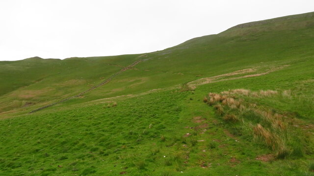
Spanning a distance of approximately 27 miles, Maiden Way follows a relatively straight path across the rugged terrain of the Cumbrian Pennines. The road was built using a combination of stone paving and gravel, showcasing the engineering expertise of the Romans. It was primarily used for military purposes, facilitating the movement of troops, supplies, and communication between the forts.

Today, Maiden Way remains largely intact, despite some areas being eroded or damaged due to natural elements and human activity. The road offers a unique glimpse into the Roman occupation of Britain, revealing their infrastructure and strategic planning.

Visitors to Maiden Way can explore various sections of the road, with some parts still retaining the original Roman pavement. The surrounding landscape provides a picturesque backdrop, showcasing the beauty of the Cumberland region.

Maiden Way is recognized as a protected heritage site, and efforts are underway to preserve and maintain its historical value. It serves as a testament to the Roman influence in the area and offers an opportunity for visitors to immerse themselves in the rich history of Cumberland.

If you have any feedback on the listing, please let us know in the comments section below.

Maiden Way Images

Images are sourced within 2km of 54.74/-2.537 or Grid Reference NY6538. Thanks to Geograph Open Source API. All images are credited.

Shepherd's hut showing the fire grate and well-constructed chimney into the stonework marked as a sheepfold on map Second wild camp close to the hut. This time I spent a few hours repairing one wall as it's just too good and remote to let it go to ruin.
Shepherd's hut showing the fire grate and well-constructed chimney into the stonework marked as a sheepfold on map
Second wild camp close to the hut. This time I spent a few hours repairing one wall as it's just too good and remote to let it go to ruin.
Shepherd's hut marked on map as a sheepfold Few hours' repairing one side. Probably constructed purely for an overnight stay to escape the harsh elements, complete with a fireplace/metal grate and  chimney. Roof was constructed out of a tree trunk for the joist and branches for the purlins, then corrugated sheeting covered it.
Shepherd's hut marked on map as a sheepfold
Few hours' repairing one side. Probably constructed purely for an overnight stay to escape the harsh elements, complete with a fireplace/metal grate and chimney. Roof was constructed out of a tree trunk for the joist and branches for the purlins, then corrugated sheeting covered it.
Shepherd's hut. Spent an hour rebuilding another section.
Shepherd's hut.
Spent an hour rebuilding another section.
Hill track ascending above Meikle Awfell above Melmerby
Summit cairn on Melmerby Fell
Cuns Fell (539m) Seen across Ousbydale from the Maiden Way. There are quite a few rounded or peaked summits along the East Fellside (the section of the North Pennines rising above the Eden Valley). Probably the best known are the "pikes" such as Dufton, Knock and Murton. They are formed from different rocks to the more usual sandstones, shales and limestones of the nearby Pennine escarpment. Some are probably volcanic in origin or igneous like the dolerite that rings High Cup and which outcrops all along this part of the fells.
Cuns Fell (539m)
Seen across Ousbydale from the Maiden Way. There are quite a few rounded or peaked summits along the East Fellside (the section of the North Pennines rising above the Eden Valley). Probably the best known are the "pikes" such as Dufton, Knock and Murton. They are formed from different rocks to the more usual sandstones, shales and limestones of the nearby Pennine escarpment. Some are probably volcanic in origin or igneous like the dolerite that rings High Cup and which outcrops all along this part of the fells.
Upright stone, Maiden Way on Melmerby Fell We saw no markings on the stone but its location near the old bridleway (and Roman Road) suggests it was a marker for the route in poor weather. No need today with Cross Fell in clear view across the moorland miles.
Upright stone, Maiden Way on Melmerby Fell
We saw no markings on the stone but its location near the old bridleway (and Roman Road) suggests it was a marker for the route in poor weather. No need today with Cross Fell in clear view across the moorland miles.
Stone by the Maiden Way This large, tapering stone just beside the track may have been a route marker when, of course it would have stood upright. There are signs of straight cuts and pittings which could conceivably be prehistoric (or just chisel marks and natural weathering). The view is towards Cuns Fell and the distant northern fells of Lakeland.
Stone by the Maiden Way
This large, tapering stone just beside the track may have been a route marker when, of course it would have stood upright. There are signs of straight cuts and pittings which could conceivably be prehistoric (or just chisel marks and natural weathering). The view is towards Cuns Fell and the distant northern fells of Lakeland.
Small tarn near the Maiden Way on Melmerby Fell The upright slab of gritstone may be a marker (similar to <a title="https://www.geograph.org.uk/photo/2770101)" href="https://www.geograph.org.uk/photo/2770101)">Link</a> - but if so, why is it here and not by the track?
Small tarn near the Maiden Way on Melmerby Fell
The upright slab of gritstone may be a marker (similar to Link - but if so, why is it here and not by the track?
Crossing Melmerby Fell on a fine frosty afternoon Firm, easy going - where else would you wish to be? Looking towards Cross Fell which looks a lot closer than it actually is.
Crossing Melmerby Fell on a fine frosty afternoon
Firm, easy going - where else would you wish to be? Looking towards Cross Fell which looks a lot closer than it actually is.
Summit cairn, Melmerby Fell Looking from the 709m top (Dun Edge) towards the large cairn on Knapside Hill. It was from here that we began to see deeply rutted trail bike tracks which took the edge of what was a superb day on the North Pennine fells.
Summit cairn, Melmerby Fell
Looking from the 709m top (Dun Edge) towards the large cairn on Knapside Hill. It was from here that we began to see deeply rutted trail bike tracks which took the edge of what was a superb day on the North Pennine fells.
Heading for Knapside Hill An easy track leads across from Melmerby Fell.
Heading for Knapside Hill
An easy track leads across from Melmerby Fell.
Trail bike damage on Knapside Hill These ruts were apparent much of the way from the footpath entry onto the open fell <a title="https://www.geograph.org.uk/photo/2771008" href="https://www.geograph.org.uk/photo/2771008">Link</a> right across to Melmerby Fell. The people who ride these bikes (illegally) on public footpaths and over fragile ground could not care less about the environment. I have reported the problem to the North Pennines AONB unit so at least they are aware of the situation.
Trail bike damage on Knapside Hill
These ruts were apparent much of the way from the footpath entry onto the open fell Link right across to Melmerby Fell. The people who ride these bikes (illegally) on public footpaths and over fragile ground could not care less about the environment. I have reported the problem to the North Pennines AONB unit so at least they are aware of the situation.
Ruined sheepfold on west flank of Knapside Hill Looking towards a distant Cross Fell.
Ruined sheepfold on west flank of Knapside Hill
Looking towards a distant Cross Fell.
Cairn above Blea Scar This large cairn is in prominent view on the descent from Knapside Hill. Across the hazy Eden Valley rise the northern fells of the Lake District.
Cairn above Blea Scar
This large cairn is in prominent view on the descent from Knapside Hill. Across the hazy Eden Valley rise the northern fells of the Lake District.
Going nowhere, very slowly The remains of what look like a tractor engine and chassis rust gently away by the footpath above Blea Scar.
Going nowhere, very slowly
The remains of what look like a tractor engine and chassis rust gently away by the footpath above Blea Scar.
Trail bike damage below Knapside Hill These ruts were apparent much of the way from the footpath entry onto the open fell right across to Melmerby Fell <a title="https://www.geograph.org.uk/photo/2770490" href="https://www.geograph.org.uk/photo/2770490">Link</a> The people who ride these bikes (illegally) on public footpaths and over fragile ground could not care less about the environment. I have reported the problem to the North Pennines AONB unit so at least they are aware of the situation.
Trail bike damage below Knapside Hill
These ruts were apparent much of the way from the footpath entry onto the open fell right across to Melmerby Fell Link The people who ride these bikes (illegally) on public footpaths and over fragile ground could not care less about the environment. I have reported the problem to the North Pennines AONB unit so at least they are aware of the situation.
Bench mark in embedded rock, footpath on Meikle Awfell An unusual situation.
Bench mark in embedded rock, footpath on Meikle Awfell
An unusual situation.
Show me another place!

Maiden Way is located at Grid Ref: NY6538 (Lat: 54.74, Lng: -2.537)

Administrative County: Cumbria

District: Eden

Police Authority: Cumbria

What 3 Words

///storyline.readily.secretly. Near Alston, Cumbria

Related Wikis

Melmerby, Cumbria

Melmerby is a village and civil parish in the Eden district, in the county of Cumbria, England. It is a small village with a population of around 200....

St John's Church, Gamblesby

St. John's Church was a Victorian parish Church of England church in the village of Gamblesby, Cumbria, England.The Gothic Revival-style church, with tall...

Gamblesby

Gamblesby is a village near Melmerby, and former civil parish, now in the parish of Glassonby, in the Westmorland and Furness district, in the ceremonial...

Ousby

Ousby is a village and civil parish in Eden district, in the English county of Cumbria. It is a Thankful Village, one of 52 parishes in England and Wales...

Cross Fell

Cross Fell is the highest mountain in the Pennines of Northern England and the highest point in England outside the Lake District. It is located in the...

Unthank, Glassonby

Unthank is a village near Gamblesby in the civil parish of Glassonby in Cumbria, England. It is first mentioned in writing as Unthanke in 1332. == See... ==

Busk, Cumbria

Busk is a hamlet in Cumbria, England. It is located 3.7 miles (6.0 km) by road to the east of Kirkoswald. == See also == List of places in Cumbria ��2...

Black Fell (Pennines)

Black Fell is a hill in the North Pennines, England. It is located just north of the A686 road, west of Alston and is one of the most northerly parts of...

Nearby Amenities

Located within 500m of 54.74,-2.537
Dun Edge
Place: locality
Lat/Long: 54.7372015/-2.5423108
Abandoned: yes
Historic: mine_shaft
Lat/Long: 54.7420111/-2.5375697
Abandoned: yes
Historic: mine_shaft
Lat/Long: 54.7423333/-2.5386016
Hard Rigg Edge
Ele: 627
Natural: peak
Lat/Long: 54.7427787/-2.5309391
Man Made: cairn
Lat/Long: 54.7384449/-2.5315673
Man Made: cairn
Lat/Long: 54.7392424/-2.5310417
Man Made: cairn
Lat/Long: 54.7406218/-2.5297327
Man Made: cairn
Lat/Long: 54.7408746/-2.5295347
The data included in this document is from www.openstreetmap.org. The data is made available under ODbL.

Have you been to Maiden Way ?

Leave your review of Maiden Way below (or comments, questions and feedback).