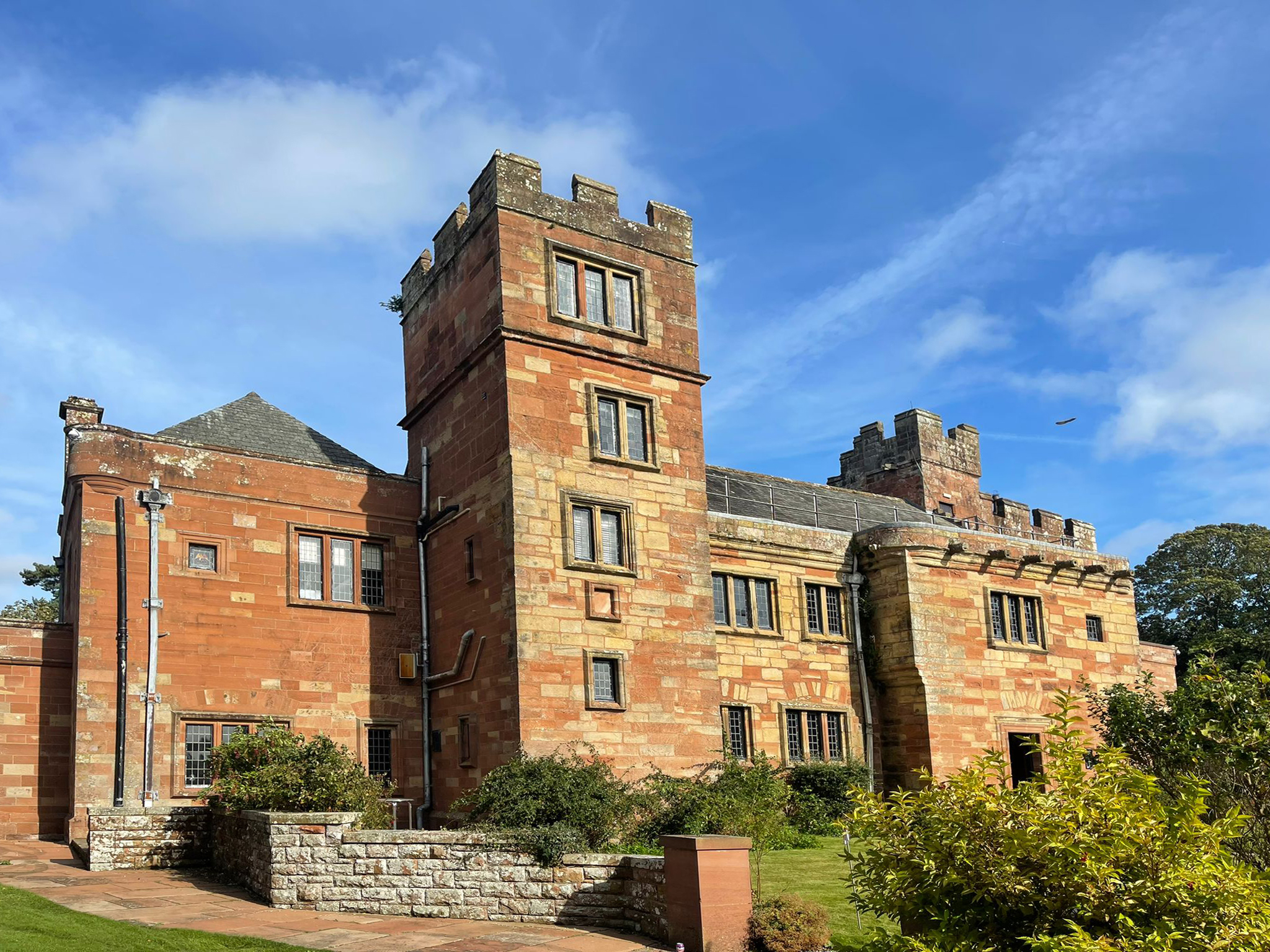
Dalston Hall

Heritage Site in Cumberland Carlisle

England

Dalston Hall

The Cumbria Way near Caldew School This path is both the Caldew Cycleway and The Cumbria Way, which follow the same tarmacked path from here to Cummersdale (next photograph <a href="https://www.geograph.org.uk/photo/7771354">NY3750 : The Caldew Cycleway near Caldew School</a>).
The grounds of Caldew School are to the left behind the fence.
The Cumbria Way near Caldew School Credit: Adrian Taylor

Dalston Hall, located in Cumberland, England, is a historical heritage site renowned for its rich history and architectural significance. Situated in the village of Dalston, just a few miles southwest of Carlisle, the hall has been an integral part of the region for centuries.

Originally built in the 15th century, Dalston Hall is an exquisite example of medieval architecture. The hall features a magnificent tower, stone walls, and a grand entrance gate, all of which contribute to its impressive appearance. Over the years, the building has undergone several alterations and extensions, blending different architectural styles and adding to its charm.

Throughout its history, Dalston Hall has witnessed numerous significant events. It has been associated with notable figures, including the Earls of Dalston, Sir John Dalston, and the Graham family. The hall served as a residence for these influential families and played a vital role in the local community.

Today, Dalston Hall stands as a testament to the area's heritage and offers visitors a chance to explore its historical significance. The hall has been converted into a luxury hotel, providing guests with a unique opportunity to experience the grandeur of the past while enjoying modern amenities. The magnificent gardens surrounding the hall further enhance its appeal, offering a serene and picturesque setting for visitors to relax and appreciate the beauty of the estate.

Dalston Hall is a cherished heritage site in Cumberland, attracting history enthusiasts, architecture lovers, and tourists alike. With its rich history, stunning architecture, and beautiful surroundings, it continues to captivate visitors with its timeless charm and elegance.

If you have any feedback on the listing, please let us know in the comments section below.

Dalston Hall Images

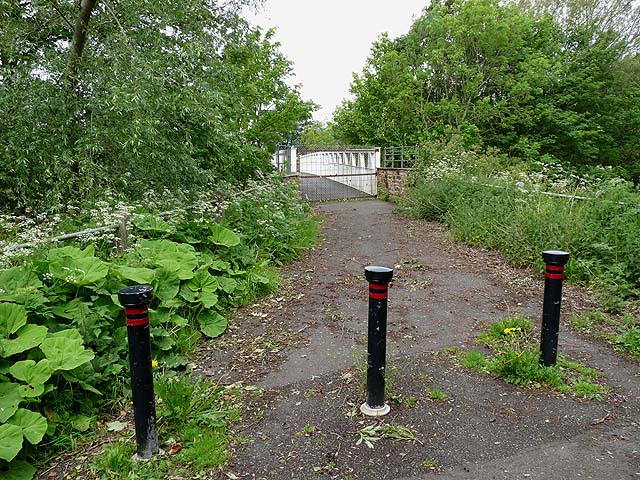
Images are sourced within 2km of 54.853/-2.973 or Grid Reference NY3751. Thanks to Geograph Open Source API. All images are credited.

The Cumbria Way near Caldew School This path is both the Caldew Cycleway and The Cumbria Way, which follow the same tarmacked path from here to Cummersdale (next photograph <a href="https://www.geograph.org.uk/photo/7771354">NY3750 : The Caldew Cycleway near Caldew School</a>).
The grounds of Caldew School are to the left behind the fence.
The Cumbria Way near Caldew School
This path is both the Caldew Cycleway and The Cumbria Way, which follow the same tarmacked path from here to Cummersdale (next photograph NY3750 : The Caldew Cycleway near Caldew School). The grounds of Caldew School are to the left behind the fence.
The Caldew Cycleway near Caldew School This path is both the Caldew Cycleway and The Cumbria Way.
The River Caldew flows behind the bushes on the right.
The Caldew Cycleway near Caldew School
This path is both the Caldew Cycleway and The Cumbria Way. The River Caldew flows behind the bushes on the right.
The Cumbria Way beside the River Caldew The path is the route of both The Cumbria Way and the Caldew Cycleway, at this point squeezed between the ugly metal palisade fencing erected by Network Rail alongside the Maryport to Carlisle railway and the fast flowing River Caldew (next photograph <a href="https://www.geograph.org.uk/photo/7723523">NY3851 : The Cumbria Way near Brownelson Wood</a>).
The rapids on the River Caldew here are caused by the hard igneous basaltic-andesite rock of the Armathwaite-Cleveland Dyke (variously known as the Cleveland Dyke, Cleveland-Armathwaite Dyke or the Armathwaite Dyke) intruding into the river bed.  The dyke, mapped at approximately 430 km (270 miles) in length was formed between 66 and 56 million years ago during the Palaeogene period and is part of the substantial dyke swarm associated with volcanic activity on the Island of Mull.
The Cumbria Way beside the River Caldew
The path is the route of both The Cumbria Way and the Caldew Cycleway, at this point squeezed between the ugly metal palisade fencing erected by Network Rail alongside the Maryport to Carlisle railway and the fast flowing River Caldew (next photograph NY3851 : The Cumbria Way near Brownelson Wood). The rapids on the River Caldew here are caused by the hard igneous basaltic-andesite rock of the Armathwaite-Cleveland Dyke (variously known as the Cleveland Dyke, Cleveland-Armathwaite Dyke or the Armathwaite Dyke) intruding into the river bed. The dyke, mapped at approximately 430 km (270 miles) in length was formed between 66 and 56 million years ago during the Palaeogene period and is part of the substantial dyke swarm associated with volcanic activity on the Island of Mull.
The Caldew Cycleway beside the River Caldew The path is the route of both the Caldew Cycleway and The Cumbria Way long distance path, at this point squeezed between the unsightly fencing bordering the Maryport to Carlisle railway, and the fast flowing River Caldew behind the bushes on the right (next photograph <a href="https://www.geograph.org.uk/photo/7771487">NY3851 : The Cumbria Way beside the River Caldew</a>).
The rapids on the River Caldew here are caused by the hard igneous basaltic-andesite rock of the Armathwaite-Cleveland Dyke (variously known as the Cleveland Dyke, Cleveland-Armathwaite Dyke or the Armathwaite Dyke) intruding into the river bed.  The dyke, with a mapped length of approximately 430 km (270 miles), was formed between 66 and 56 million years ago during the Palaeogene period and is part of a substantial dyke swarm associated with volcanic activity on the Island of Mull.
The Caldew Cycleway beside the River Caldew
The path is the route of both the Caldew Cycleway and The Cumbria Way long distance path, at this point squeezed between the unsightly fencing bordering the Maryport to Carlisle railway, and the fast flowing River Caldew behind the bushes on the right (next photograph NY3851 : The Cumbria Way beside the River Caldew). The rapids on the River Caldew here are caused by the hard igneous basaltic-andesite rock of the Armathwaite-Cleveland Dyke (variously known as the Cleveland Dyke, Cleveland-Armathwaite Dyke or the Armathwaite Dyke) intruding into the river bed. The dyke, with a mapped length of approximately 430 km (270 miles), was formed between 66 and 56 million years ago during the Palaeogene period and is part of a substantial dyke swarm associated with volcanic activity on the Island of Mull.
The Cumbria Way near Lowmill The Cumbria Way follows the Caldew Cycleway between the River Caldew (hidden behind the bushes on the right) and the Cumbrian Coast Line partly concealed behind the metal palisade fencing (next photograph <a href="https://www.geograph.org.uk/photo/7771629">NY3851 : The Caldew Cycleway beside the River Caldew</a>).
The Cumbria Way near Lowmill
The Cumbria Way follows the Caldew Cycleway between the River Caldew (hidden behind the bushes on the right) and the Cumbrian Coast Line partly concealed behind the metal palisade fencing (next photograph NY3851 : The Caldew Cycleway beside the River Caldew).
The Cumbria Way near Lowmill The Cumbria Way follows the Caldew Cycleway approaching the Whitehaven to Carlisle railway line (next photograph <a href="https://www.geograph.org.uk/photo/7771938">NY3851 : The Cumbria Way near Lowmill</a>).
The tail race of the former mill at Lowmill passes under the path at this point; no longer required for its original purpose it takes the water from a small beck that drains Dalston Common.
The Cumbria Way near Lowmill
The Cumbria Way follows the Caldew Cycleway approaching the Whitehaven to Carlisle railway line (next photograph NY3851 : The Cumbria Way near Lowmill). The tail race of the former mill at Lowmill passes under the path at this point; no longer required for its original purpose it takes the water from a small beck that drains Dalston Common.
Nestlé Factory, Dalston Adjacent to The Cumbria Way and the Caldew Cycleway, the Nestlé factory employs over three hundred people in Dalston, using on average 63 million litres of milk annually to produce a range of Nescafé products, Latte, and Coffee Mate, the latter being a whitener for beverages.
Nestlé Factory, Dalston
Adjacent to The Cumbria Way and the Caldew Cycleway, the Nestlé factory employs over three hundred people in Dalston, using on average 63 million litres of milk annually to produce a range of Nescafé products, Latte, and Coffee Mate, the latter being a whitener for beverages.
Gateway on The Caldew Cycleway Near Lowmill, the gate for pedestrians and maintenance vehicles on the Caldew Cycleway has been removed, rendering the adjacent cattle grid for cyclists redundant.
This is the route of The Cumbria Way long distance path from Ulverston to Carlisle (next photograph <a href="https://www.geograph.org.uk/photo/7771996">NY3751 : The Cumbria Way near Lowmill</a>).
Gateway on The Caldew Cycleway
Near Lowmill, the gate for pedestrians and maintenance vehicles on the Caldew Cycleway has been removed, rendering the adjacent cattle grid for cyclists redundant. This is the route of The Cumbria Way long distance path from Ulverston to Carlisle (next photograph NY3751 : The Cumbria Way near Lowmill).
The Cumbria Way near Lowmill The Cumbria Way follows the Caldew Cycleway near Lowmill (next photograph <a href="https://www.geograph.org.uk/photo/7773037">NY3751 : Gateway on The Caldew Cycleway</a>).
This is the route of National Cycle Network Routes 7 and 10.
The Cumbria Way near Lowmill
The Cumbria Way follows the Caldew Cycleway near Lowmill (next photograph NY3751 : Gateway on The Caldew Cycleway). This is the route of National Cycle Network Routes 7 and 10.
The Cumbria Way, Lowmill The Cumbria Way long distance path follows the Caldew Cycleway near Lowmill (next photograph <a href="https://www.geograph.org.uk/photo/7773069">NY3751 : The Cumbria Way near Lowmill</a>); this is also the route of National Cycle Network Routes 7 and 10.
The footpath sign points left to the B5299 Carlisle Road via Lowmill and Low Mill Level Crossing.
The Cumbria Way, Lowmill
The Cumbria Way long distance path follows the Caldew Cycleway near Lowmill (next photograph NY3751 : The Cumbria Way near Lowmill); this is also the route of National Cycle Network Routes 7 and 10. The footpath sign points left to the B5299 Carlisle Road via Lowmill and Low Mill Level Crossing.
The Cumbria Way near Lowmill The Cumbria Way long distance path follows the Caldew Cycleway near Lowmill (next photograph <a href="https://www.geograph.org.uk/photo/7773666">NY3751 : The Cumbria Way, Lowmill</a>); this is also the route of National Cycle Network Routes 7 and 10.
Previously there was a gate for pedestrians here with a small cattle grid to allow cyclists to pass.  The gate has been removed and the cattle grid, between the short fences, is becoming overgrown.
The Cumbria Way near Lowmill
The Cumbria Way long distance path follows the Caldew Cycleway near Lowmill (next photograph NY3751 : The Cumbria Way, Lowmill); this is also the route of National Cycle Network Routes 7 and 10. Previously there was a gate for pedestrians here with a small cattle grid to allow cyclists to pass. The gate has been removed and the cattle grid, between the short fences, is becoming overgrown.
The Cumbria Way near Dalston The Cumbria Way follows the Caldew Cycleway between Dalston and Lowmill (next photograph <a href="https://www.geograph.org.uk/photo/7773683">NY3751 : The Cumbria Way near Lowmill</a>).
This is the route of National Cycle Network Routes 7 and 10.
The Cumbria Way near Dalston
The Cumbria Way follows the Caldew Cycleway between Dalston and Lowmill (next photograph NY3751 : The Cumbria Way near Lowmill). This is the route of National Cycle Network Routes 7 and 10.
Road from Durdar to Dalston
A sad tale of the Millennium Along with many communities, Dalston Parish Council inaugurated a number of public works to commemorate the new Millennium. These included the rebuilding of the White Bridge, a foot and cycle bridge over the River Caldew; and tree planting and the erection of a bench on the east bank.

In October 2010, it was discovered that 80 % of the foundations of the central pier had been eroded away by the river, and the bridge was promptly closed for safety reasons. The bench (the top of which can just be seen) rapidly became overgrown, being no longer readily accessible from  the village.

Hopefully there is a happy end to this story. It was planned to commence repairs in June 2011, shortly after this photograph was taken.
A sad tale of the Millennium
Along with many communities, Dalston Parish Council inaugurated a number of public works to commemorate the new Millennium. These included the rebuilding of the White Bridge, a foot and cycle bridge over the River Caldew; and tree planting and the erection of a bench on the east bank. In October 2010, it was discovered that 80 % of the foundations of the central pier had been eroded away by the river, and the bridge was promptly closed for safety reasons. The bench (the top of which can just be seen) rapidly became overgrown, being no longer readily accessible from the village. Hopefully there is a happy end to this story. It was planned to commence repairs in June 2011, shortly after this photograph was taken.
A sad tale of the Millennium Along with many communities, Dalston Parish Council inaugurated a number of public works to commemorate the new Millennium. These included the rebuilding of the White Bridge, a foot and cycle bridge over the River Caldew; and tree planting and the erection of a bench on the east bank.

In October 2010, it was discovered that 80 % of the foundations of the central pier had been eroded away by the river, and the bridge was promptly closed for safety reasons. The bench rapidly became overgrown, being no longer readily accessible from  the village.

It was planned to commence repairs in June 2011, shortly after this photograph was taken.
A sad tale of the Millennium
Along with many communities, Dalston Parish Council inaugurated a number of public works to commemorate the new Millennium. These included the rebuilding of the White Bridge, a foot and cycle bridge over the River Caldew; and tree planting and the erection of a bench on the east bank. In October 2010, it was discovered that 80 % of the foundations of the central pier had been eroded away by the river, and the bridge was promptly closed for safety reasons. The bench rapidly became overgrown, being no longer readily accessible from the village. It was planned to commence repairs in June 2011, shortly after this photograph was taken.
Grass fields near Dalston Land south of Carlisle appears to be mainly grazing land. Little sign of livestock, the cattle will be inside for the Winter.
Grass fields near Dalston
Land south of Carlisle appears to be mainly grazing land. Little sign of livestock, the cattle will be inside for the Winter.
Bridge restored! Once again the White Bridge is open (see <a href="https://www.geograph.org.uk/photo/2455212">NY3749 : A sad tale of the Millennium</a>).
Bridge restored!
Once again the White Bridge is open (see NY3749 : A sad tale of the Millennium).
The White Bridge Originally opened in 1899 and restored in 1999 for the Millennium. Severe erosion of the supporting pier led to its closure in 2010, but now thankfully repaired and reopened (see <a href="https://www.geograph.org.uk/photo/2455212">NY3749 : A sad tale of the Millennium</a>).
The White Bridge
Originally opened in 1899 and restored in 1999 for the Millennium. Severe erosion of the supporting pier led to its closure in 2010, but now thankfully repaired and reopened (see NY3749 : A sad tale of the Millennium).
Show me another place!

Dalston Hall is located at Grid Ref: NY3751 (Lat: 54.853, Lng: -2.973)

Administrative County: Cumbria

District: Carlisle

Police Authority: Cumbria

What 3 Words

///meant.hints.crisis. Near Dalston, Cumbria

Related Wikis

Dalston Hall

Dalston Hall is a fortified country house at Dalston in Cumbria, England. It is a Grade II* listed building. == History == Dalston Hall was built around...

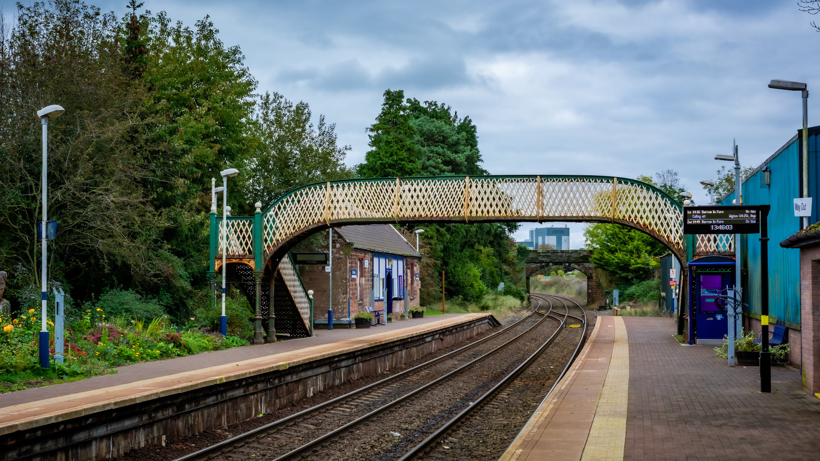
Dalston railway station (Cumbria)

Dalston railway station serves the village of Dalston near Carlisle in Cumbria, England. It is on the Cumbrian Coast Line, which runs between Carlisle...
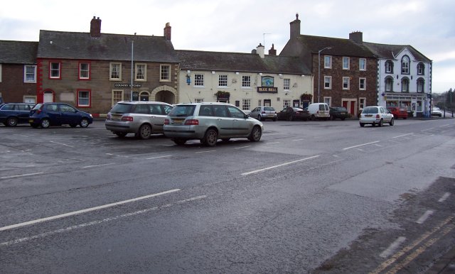
Dalston, Cumbria

Dalston is a large village and civil parish within Cumberland unitary authority area, Cumbria, and historically part of Cumberland. It is situated on the...

Cummersdale railway station

Cummersdale was a railway station on the Maryport and Carlisle Railway (M&CR) serving Cummersdale in Cumbria. The station was opened by the M&CR in 1858...

Nearby Amenities

Located within 500m of 54.853,-2.973
Lowmill Road End
Naptan AtcoCode: 090033154153
Naptan Bearing: S
Naptan BusStopType: CUS
Naptan CommonName: Lowmill Road End
Naptan Indicator: Near
Naptan Landmark: Caldewhurst
Naptan NaptanCode: cumdptad
Naptan Street: Carlisle Road
Naptan Verified: no
Source: naptan_import
Lat/Long: 54.8520655/-2.976342
Parking
Source: survey
Lat/Long: 54.8511617/-2.976558
Power: pole
Lat/Long: 54.8545395/-2.9657692
Power: pole
Lat/Long: 54.8540889/-2.9669363
Power: pole
Lat/Long: 54.8535934/-2.9682355
Power: pole
Lat/Long: 54.8529935/-2.9694568
Power: pole
Lat/Long: 54.8524003/-2.9706664
Power: pole
Lat/Long: 54.8518506/-2.9718312
Power: pole
Lat/Long: 54.8515899/-2.9710484
Power: pole
Lat/Long: 54.8511515/-2.9697846
Power: pole
Lat/Long: 54.8507443/-2.968641
Power: pole
Lat/Long: 54.8500683/-2.9694073
Power: pole
Lat/Long: 54.8494574/-2.9709588
Power: pole
Lat/Long: 54.8487366/-2.9727696
Power: pole
Lat/Long: 54.850566/-2.9786398
Power: pole
Lat/Long: 54.8572081/-2.9751061
The data included in this document is from www.openstreetmap.org. The data is made available under ODbL.

Have you been to Dalston Hall ?

Leave your review of Dalston Hall below (or comments, questions and feedback).