Castle Goring

Heritage Site in Sussex Worthing

England

Castle Goring

Footpath junction with Grub Ride
Footpath junction with Grub Ride Credit: Shazz

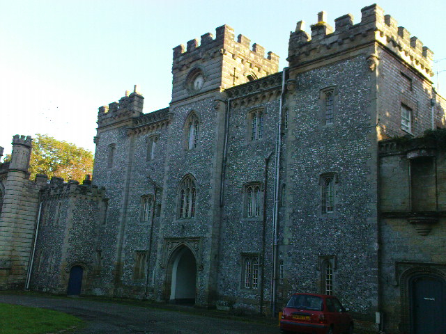
Castle Goring is a historic castle located in Sussex, England. Situated near Worthing, the castle has a rich history that dates back to the 18th century. It is a Grade I listed building and is considered a heritage site of significant importance.

Originally built in 1795 by John Nash, the renowned architect, Castle Goring showcases a stunning example of neo-Gothic architecture. The castle's design features intricate detailing, including pointed arches, ornate windows, and a prominent tower. The castle is surrounded by beautiful gardens and grounds, providing a picturesque setting for visitors.

Throughout its history, Castle Goring has been associated with several notable figures. It was once owned by the Duke of Norfolk and later purchased by the famous playwright and author, Sir Paul Getty. The castle has also been used as a filming location for various movies and television shows, adding to its cultural significance.

Today, Castle Goring is open to the public, offering guided tours that allow visitors to explore the castle's rich history and architectural beauty. The interior of the castle boasts elegant rooms with period furnishings, showcasing the grandeur of the past. The gardens, meticulously maintained, offer visitors a peaceful retreat and serve as a backdrop for weddings and other events.

Castle Goring stands as a testament to the rich heritage and architectural prowess of the region. Its historical significance, stunning design, and picturesque surroundings make it a popular destination for history enthusiasts, architecture lovers, and those seeking a tranquil escape in the heart of Sussex.

If you have any feedback on the listing, please let us know in the comments section below.

Castle Goring Images

Images are sourced within 2km of 50.838/-0.43 or Grid Reference TQ1005. Thanks to Geograph Open Source API. All images are credited.

Footpath junction with Grub Ride
Looking west on Grub Ride from bridleway crossing Quite high in the trees on the left is a notice declaring PRIVATE  and No public right of way.
Looking west on Grub Ride from bridleway crossing
Quite high in the trees on the left is a notice declaring PRIVATE and No public right of way.
Weatherbird by bridleway What sort of bird is it?
Weatherbird by bridleway
What sort of bird is it?
Bridleway passes Keepers Cottage See also <a title="https://www.geograph.org.uk/photo/3535503" href="https://www.geograph.org.uk/photo/3535503">Link</a>.
Bridleway passes Keepers Cottage
See also Link.
Weathercock by bridleway
Path east to bridleway It's a moot point as to which side of the hedge is the path.
Path east to bridleway
It's a moot point as to which side of the hedge is the path.
Field gate and stile east of Clapham This was taken looking back the way I had come. I had not used the stile and had been on the wrong side of the hedge.
Field gate and stile east of Clapham
This was taken looking back the way I had come. I had not used the stile and had been on the wrong side of the hedge.
Footpath joins bridleway in Clapham Wood
Bridleway going northwards from footpath junction A view the other way is at <a title="https://www.geograph.org.uk/photo/2635796" href="https://www.geograph.org.uk/photo/2635796">Link</a>.
Bridleway going northwards from footpath junction
A view the other way is at Link.
Roundabout on Littlehampton Road with pedestrian bridge
Looking north on Titnore Lane
Houses at byway junction on Titnore Lane
Restricted byway goes west from Titnore Lane
Looking north on Titnore Lane
Titnore Lane looking north from small bridge
Titnore Lane looking south from small bridge
Looking south on Salvington Hill
Entrance to Salvington Lodge
Show me another place!

Castle Goring is located at Grid Ref: TQ1005 (Lat: 50.838, Lng: -0.43)

Administrative County: West Sussex

District: Worthing

Police Authority: Sussex

What 3 Words

///bandstand.stumps.taster. Near Goring-by-Sea, West Sussex

Nearby Locations

Garden Wood Castle Goring

Related Wikis

Castle Goring

Castle Goring is a country house in Worthing, in West Sussex, England about 4.5 miles (7 kilometres) northwest of the town centre. One of Worthing's two...

Titnore Wood

Titnore Wood is an area of ancient woodland to the north-west of Worthing in West Sussex. With neighbouring Goring Wood it forms one of the last remaining...

Cote, West Sussex

Cote (also Walcote or Coate) was a hamlet in the former parish of Durrington, West Sussex (now a suburb of Worthing), England. It is 3 miles (4.8 km) northwest...

Northbrook (electoral division)

Northbrook is an electoral division of West Sussex in the United Kingdom, and returns one member to sit on West Sussex County Council. == Extent == The...

Nearby Amenities

Located within 500m of 50.838,-0.43
Bus Stop
Castle Goring Mews
Naptan AtcoCode: 4400LH0353
Naptan Bearing: E
Naptan CommonName: Castle Goring Mews
Naptan Indicator: Centre
Naptan Landmark: Holt Farm
Naptan NaptanCode: wsxdatdw
Naptan Street: A27
Naptan Verified: no
Source: naptan_import
Lat/Long: 50.8402098/-0.4318548
Coach & Horses
Naptan AtcoCode: 4400LH0354
Naptan Bearing: E
Naptan BusStopType: CUS
Naptan CommonName: Coach & Horses
Naptan Indicator: opp. Stanhope Farm
Naptan Landmark: Stanhope Farm
Naptan NaptanCode: wsxdatga
Naptan Street: A27
Naptan Verified: no
Source: naptan_import
Lat/Long: 50.8404269/-0.4246037
Bus Stop
Coach & Horses
Naptan AtcoCode: 4400LH0355
Naptan Bearing: W
Naptan CommonName: Coach & Horses
Naptan Indicator: adj Stanhope Farm
Naptan Landmark: Stanhope Farm
Naptan NaptanCode: wsxdatgd
Naptan Street: A27
Naptan Verified: no
Source: naptan_import
Lat/Long: 50.8399918/-0.4256836
Bus Stop
Castle Goring Mews
Naptan AtcoCode: 4400LH0356
Naptan Bearing: W
Naptan CommonName: Castle Goring Mews
Naptan Indicator: Centre
Naptan Landmark: Castle Goring Mews
Naptan NaptanCode: wsxdatgj
Naptan Street: A27
Naptan Verified: no
Source: naptan_import
Lat/Long: 50.8400478/-0.4331812
Noexit: yes
Lat/Long: 50.8376952/-0.4254426
The data included in this document is from www.openstreetmap.org. The data is made available under ODbL.

Have you been to Castle Goring?

Leave your review of Castle Goring below (or comments, questions and feedback).