Carn Fawr

Heritage Site in Cardiganshire

Wales

Carn Fawr

Ordnance Survey Cut Mark This OS cut mark can be found on the wall SW side of the road. It marks a point 249.363m above mean sea level.
Ordnance Survey Cut Mark Credit: Adrian Dust

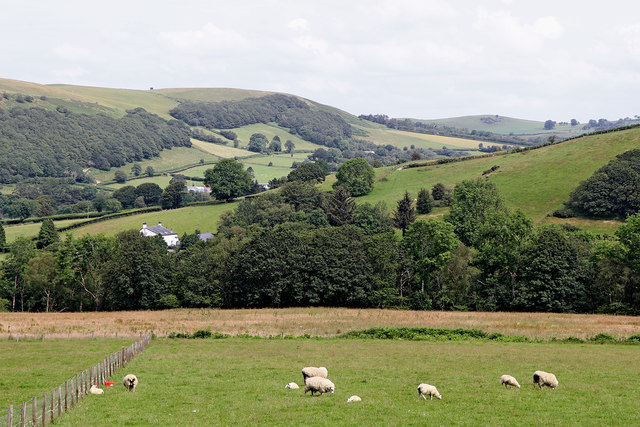
Carn Fawr is a significant heritage site located in Cardiganshire, Wales. It is a prominent hill situated near the village of Llandysul, offering spectacular views of the surrounding countryside. The name "Carn Fawr" translates to "large cairn" in English, which accurately describes the main feature of this site.

The hill is known for its Bronze Age burial mound, which is believed to have been constructed around 2000 BC. The cairn is circular in shape and measures approximately 30 meters in diameter. It is made up of stones and earth, with a central chamber where human remains were once interred. The site has undergone various excavations over the years, revealing artifacts such as pottery and flint tools, providing valuable insights into the lives of the people who inhabited the area during the Bronze Age.

Carn Fawr has great cultural and historical significance, representing the ancient burial practices of the region's early inhabitants. It is a protected heritage site under the care of Cadw, the Welsh Government's historic environment service. Visitors to Carn Fawr can explore the site and observe the cairn up close, taking in the impressive craftsmanship and architectural design of this ancient burial structure.

The hill is surrounded by beautiful countryside, making it an attractive destination for nature enthusiasts and history buffs alike. The panoramic views from the top of Carn Fawr are breathtaking, offering a unique perspective of the Welsh landscape. The site is easily accessible, with parking facilities available nearby, and is a must-visit for anyone interested in the rich cultural heritage of Cardiganshire.

If you have any feedback on the listing, please let us know in the comments section below.

Carn Fawr Images

Images are sourced within 2km of 52.2/-3.895 or Grid Reference SN7057. Thanks to Geograph Open Source API. All images are credited.

Ordnance Survey Cut Mark This OS cut mark can be found on the wall SW side of the road. It marks a point 249.363m above mean sea level.
Ordnance Survey Cut Mark
This OS cut mark can be found on the wall SW side of the road. It marks a point 249.363m above mean sea level.
Ordnance Survey Cut Mark This OS cut mark can be found on the NW parapet of the bridge. It marks a point 256.634m above mean sea level.
Ordnance Survey Cut Mark
This OS cut mark can be found on the NW parapet of the bridge. It marks a point 256.634m above mean sea level.
Ordnance Survey Cut Mark This OS cut mark can be found on the wall NE side of the road. It marks a point 247.363m above mean sea level.
Ordnance Survey Cut Mark
This OS cut mark can be found on the wall NE side of the road. It marks a point 247.363m above mean sea level.
Ordnance Survey Cut Mark This OS cut mark can be found on the wall south side of the road. It marks a point 271.771m above mean sea level.
Ordnance Survey Cut Mark
This OS cut mark can be found on the wall south side of the road. It marks a point 271.771m above mean sea level.
Llwybr ceffyl ger Bryn-wernen / A bridleway near Bryn-wernen Llwybr ceffyl yn mynd i lawr y waered ar lan Nant Cou ger Ffarm Bryn-wernen.


A bridleway descending alongside Nant Cou (trans. ravine stream) near Bryn-wernen Farm (trans. willow hill).
Llwybr ceffyl ger Bryn-wernen / A bridleway near Bryn-wernen
Llwybr ceffyl yn mynd i lawr y waered ar lan Nant Cou ger Ffarm Bryn-wernen. A bridleway descending alongside Nant Cou (trans. ravine stream) near Bryn-wernen Farm (trans. willow hill).
Cyffordd o lwybrau ceffyl / A junction of bridleways Cyffordd o lwybrau ceffyl ger Ffarm Bryn-wernen. Yn ddiddorol ddigon nid yw'r llwybr ar y chwith yn cael ei nodi ar Fap OS.

A junction of bridleways near Bryn-wernen Farm (trans. willow hill). Interestingly enough the bridleway branching away on the left is not marked on the OS Map.
Cyffordd o lwybrau ceffyl / A junction of bridleways
Cyffordd o lwybrau ceffyl ger Ffarm Bryn-wernen. Yn ddiddorol ddigon nid yw'r llwybr ar y chwith yn cael ei nodi ar Fap OS. A junction of bridleways near Bryn-wernen Farm (trans. willow hill). Interestingly enough the bridleway branching away on the left is not marked on the OS Map.
Llwybr ceffyl ger Bryn-wernen / A bridleway near Bryn-wernen Llwybr ceffyl ger Ffarm Bryn-wernen. Yn  ddiddorol ddigon nid yw'r llwybr hwn wedi cael ei nodi ar fap OS.

A bridleway near Bryn-wernen Farm (trans. willow hill). Interestingly enough this path is not marked on OS Maps.
Llwybr ceffyl ger Bryn-wernen / A bridleway near Bryn-wernen
Llwybr ceffyl ger Ffarm Bryn-wernen. Yn ddiddorol ddigon nid yw'r llwybr hwn wedi cael ei nodi ar fap OS. A bridleway near Bryn-wernen Farm (trans. willow hill). Interestingly enough this path is not marked on OS Maps.
Heol fynediad Glangors / Glangors access road Llwybr ceffyl a heol fynediad i Langors.

A bridleway and access road to Glangors (trans. on the banks of the fen).
Heol fynediad Glangors / Glangors access road
Llwybr ceffyl a heol fynediad i Langors. A bridleway and access road to Glangors (trans. on the banks of the fen).
Llwybr ceffyl ger Glangors / Bridleway near Glangors Llwybr ceffyl ger amhedd-dy o'r enw Glangors.

A bridleway near a property called Glangors (trans. on the banks of the fen).
Llwybr ceffyl ger Glangors / Bridleway near Glangors
Llwybr ceffyl ger amhedd-dy o'r enw Glangors. A bridleway near a property called Glangors (trans. on the banks of the fen).
Farmland and forest east of Tregaron in Ceredigion About a mile east of Tregaron north of the Abergwesyn road at the lower end of Cwm Berwyn, and looking towards Cwm Groes.
Farmland and forest east of Tregaron in Ceredigion
About a mile east of Tregaron north of the Abergwesyn road at the lower end of Cwm Berwyn, and looking towards Cwm Groes.
Farmland and forest east of Tregaron in Ceredigion About a mile east of Tregaron north of the Abergwesyn road. The Afon Berwyn flows through the woodland at the end of the field. Beyond those trees is Cwm Groes.
Farmland and forest east of Tregaron in Ceredigion
About a mile east of Tregaron north of the Abergwesyn road. The Afon Berwyn flows through the woodland at the end of the field. Beyond those trees is Cwm Groes.
Ceredigion farmland ast of Tregaron Looking north across the wide lower section of Cwm Berwyn towards Cwm Groes.
Ceredigion farmland ast of Tregaron
Looking north across the wide lower section of Cwm Berwyn towards Cwm Groes.
Ceredigion farmland east of Tregaron
Farm road east of Tregaron in Ceredigion This half mile private driveway leads to the farm at Llwyngaru.
Farm road east of Tregaron in Ceredigion
This half mile private driveway leads to the farm at Llwyngaru.
Ruined Farmstead, Nant Carfan, Ceredigion This was quite a substantial building. The public "route" up the valley stops here, though the track continues eastwards another mile or so.
Ruined Farmstead, Nant Carfan, Ceredigion
This was quite a substantial building. The public "route" up the valley stops here, though the track continues eastwards another mile or so.
Rough Grazing and Mountain Track, Nant Carfan, Ceredigion The well designated route from the Teifi at Pont Carfan is less well defined from here to its end one mile ahead. For some reason only the lower half of the route is designated now as a public way.
Rough Grazing and Mountain Track, Nant Carfan, Ceredigion
The well designated route from the Teifi at Pont Carfan is less well defined from here to its end one mile ahead. For some reason only the lower half of the route is designated now as a public way.
Hillside and Ruin, Nant carfan, Ceredigion
Ruined Farmstead, Nant Carfan, Ceredigion
Show me another place!

Carn Fawr is located at Grid Ref: SN7057 (Lat: 52.2, Lng: -3.895)

Unitary Authority: Ceredigion

Police Authority: Dyfed Powys

What 3 Words

///stir.distilled.camped. Near Tregaron, Ceredigion

Nearby Locations

Esgair Fraith Carn Fawr

Related Wikis

Pentre, Ceredigion

Pentre is a small area in the community of Tregaron, Ceredigion, Wales, which is 60.4 miles (97.2 km) from Cardiff and 169.5 miles (272.8 km) from London...

Tregaron Hospital

Tregaron Hospital (Welsh: Ysbyty Tregaron) is a community hospital in Tregaron, Wales. It is managed by the Hywel Dda University Health Board. == History... ==

River Brenig

The River Brenig (Afon Brenig) is a tributary river of the River Teifi and runs through the market town of Tregaron in Ceredigion, Wales. It is formed...

Tregaron

Tregaron (Welsh: [treˈɡaːrɔn] "town of St Caron") is an ancient market town in Ceredigion, Wales. It is sited astride the River Brenig, a tributary of...

Have you been to Carn Fawr?

Leave your review of Carn Fawr below (or comments, questions and feedback).