Cadair Idris

Heritage Site in Merionethshire

Wales

Cadair Idris

Summit plateau of Cadair Idris
Summit plateau of Cadair Idris Credit: Steven Brown

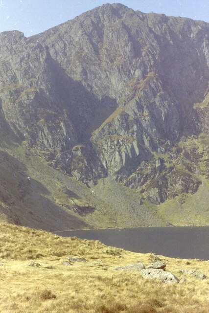
Cadair Idris, located in Merionethshire, Wales, is a prominent mountain in Snowdonia National Park. Standing at a height of 893 meters (2,930 feet), it is one of the most popular destinations for hikers and outdoor enthusiasts in the region. The name Cadair Idris translates to "Idris' Chair" in English, referring to a legendary giant named Idris who was said to have sat on the mountain to contemplate the stars.

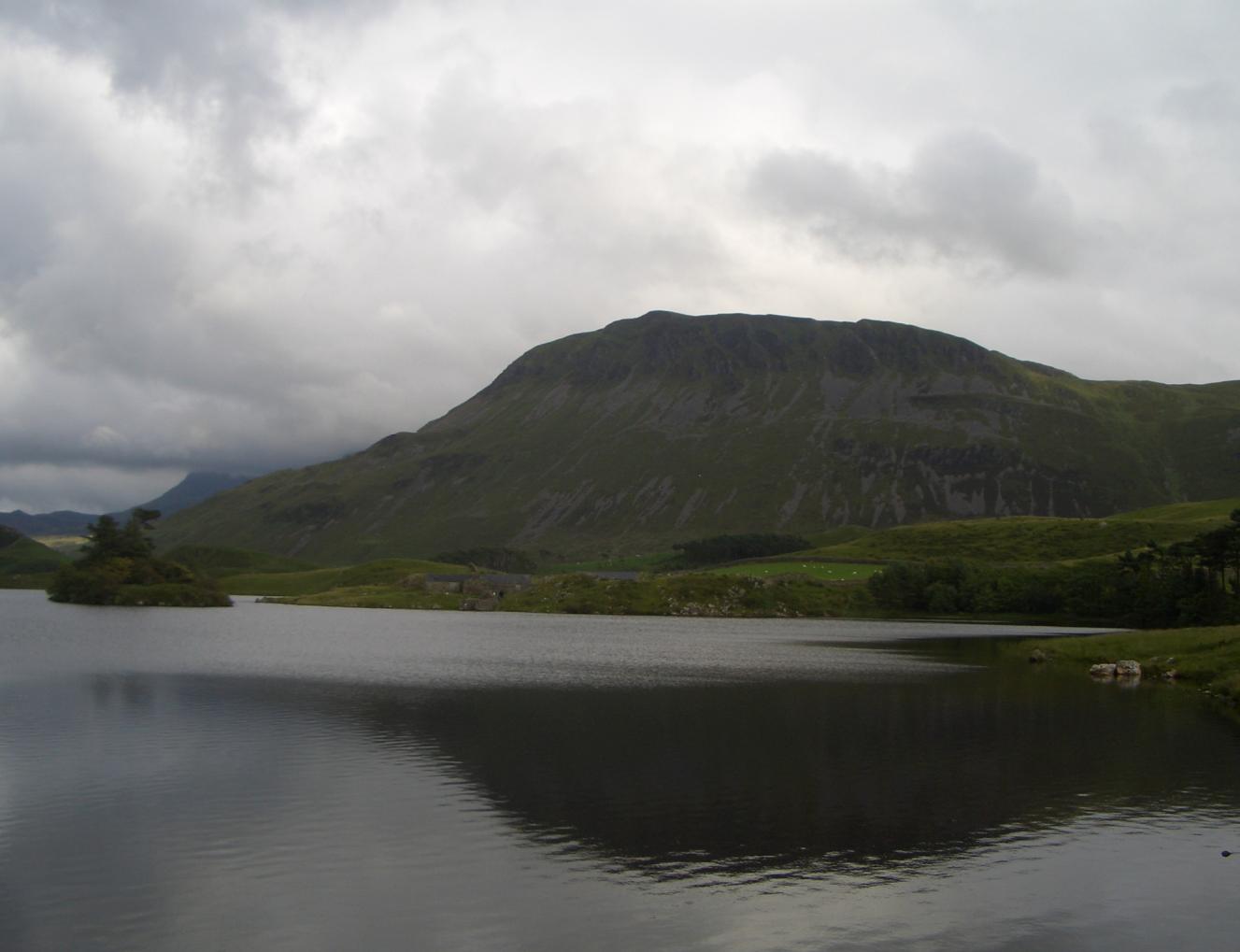
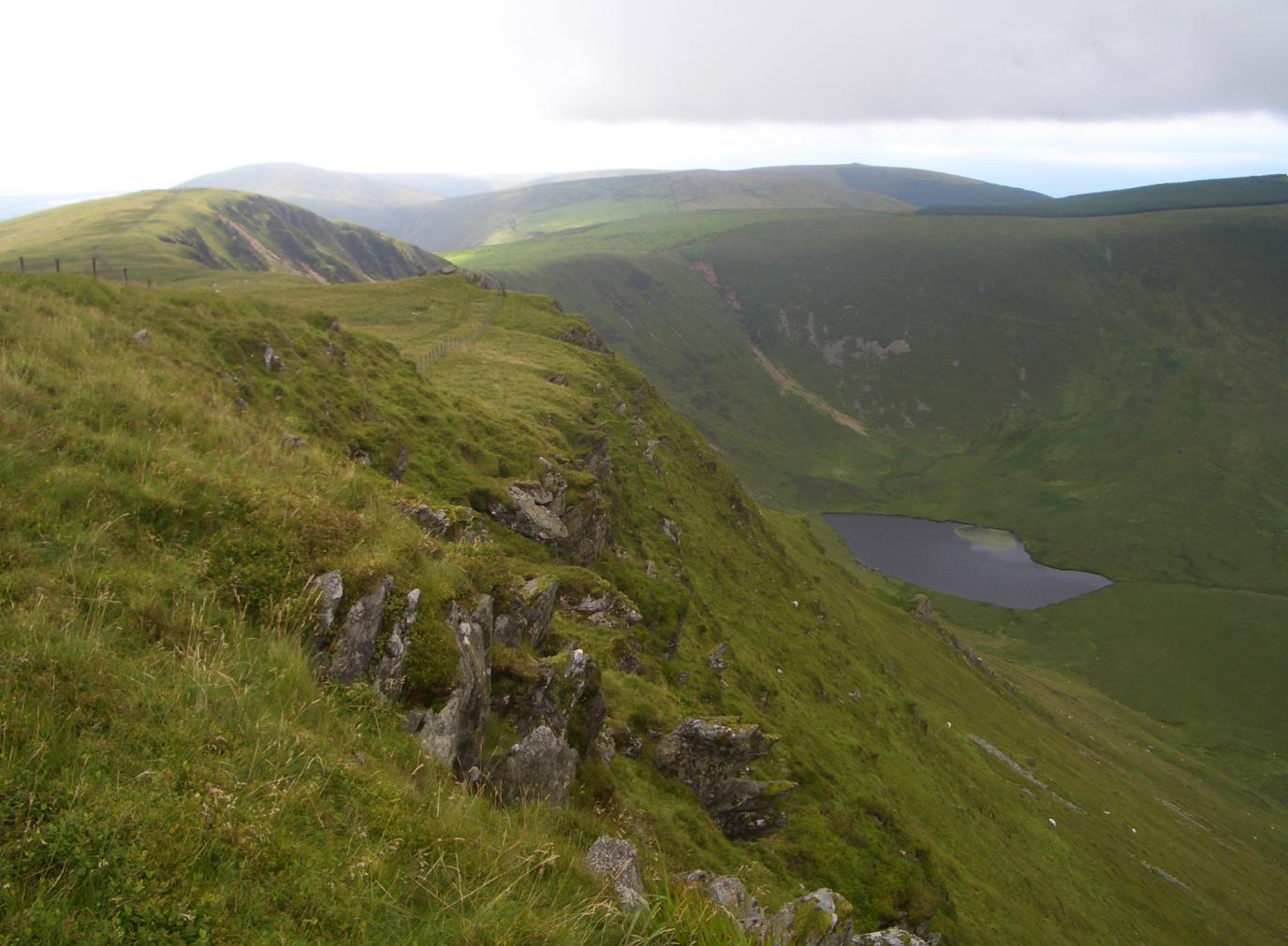
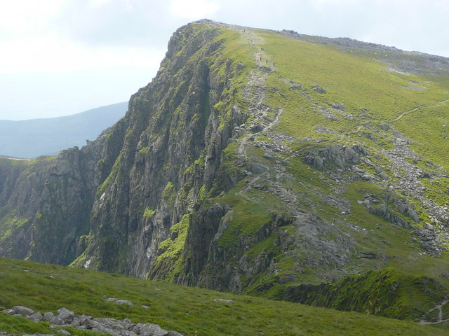
The mountain offers breathtaking panoramic views of the surrounding landscape, including the Mawddach Estuary, the Rhinogydd mountain range, and the peaks of Snowdonia. Its distinctive features include steep cliffs, rocky outcrops, and glacial valleys, adding to its scenic allure.

Cadair Idris is not only renowned for its natural beauty but also for its rich cultural and historical significance. It has a strong connection to Welsh mythology and folklore, with numerous legends and tales associated with the mountain. Additionally, the area has evidence of prehistoric settlements, including Bronze Age cairns and Iron Age hillforts, further enhancing its historical importance.

The mountain boasts a variety of walking and hiking trails, catering to all levels of experience. The most popular route is the Pony Path, a well-maintained track that leads to the summit. Other routes, like the Fox's Path and the Minffordd Path, offer more challenging and scenic options for experienced hikers.

Cadair Idris is not only a haven for outdoor enthusiasts but also a protected site, recognized for its ecological diversity. It is home to a wide range of flora and fauna, including rare species such as the Snowdon lily and the peregrine falcon.

Overall, Cadair Idris is a cherished heritage site that captivates visitors with its natural beauty, cultural significance, and challenging trails, making it a must-visit destination for those exploring the wonders of Wales.

If you have any feedback on the listing, please let us know in the comments section below.

Cadair Idris Images

Images are sourced within 2km of 52.705/-3.924 or Grid Reference SH7013. Thanks to Geograph Open Source API. All images are credited.

Summit plateau of Cadair Idris
Trig point on Penygadair
Craig Cau above Llyn Cau
Llyn-y-Gadair below Cadair Idris Glacial oligotrophic lake viewed from Penygadair.
Llyn-y-Gadair below Cadair Idris
Glacial oligotrophic lake viewed from Penygadair.
South from Penygadair Penygadair is the highest top on Cader Idris. Craig Cau is in the mid-distance. The Talyllyn valley is beyond.
South from Penygadair
Penygadair is the highest top on Cader Idris. Craig Cau is in the mid-distance. The Talyllyn valley is beyond.
Outcrops, Penygadair East of the summit. Looking south, over the Talyllyn valley.
Outcrops, Penygadair
East of the summit. Looking south, over the Talyllyn valley.
East of the summit, Penygadair Looking east along the broad ridge to Mynydd Moel.
East of the summit, Penygadair
Looking east along the broad ridge to Mynydd Moel.
Llyn Cau
Llyn Cau
Break in the clouds over Llyn Cau
Craig Cau
Craig Cau
The Saddle and Llyn y Gadair from Penygadair
Trig Point on Penygadair
Path towards Mynydd Moel
Llyn Gader Having taken the Pony Path from Ty Nant car park, reaching above Llyn Gadair, before final scramble to summit of Penygadair (Cadair Idris) <span class="nowrap"><a title="https://snowdonia.gov.wales/walk/pony-path-ty-nant/" rel="nofollow ugc noopener" href="https://snowdonia.gov.wales/walk/pony-path-ty-nant/">Link</a><img style="margin-left:2px;" alt="External link" title="External link - shift click to open in new window" src="https://s1.geograph.org.uk/img/external.png" width="10" height="10"/></span>
Llyn Gader
Having taken the Pony Path from Ty Nant car park, reaching above Llyn Gadair, before final scramble to summit of Penygadair (Cadair Idris) LinkExternal link
Long way down to Llyn Cau Pretty much exactly the same image as <a href="https://www.geograph.org.uk/photo/967868">SH7112 : Llyn Cau through a cleft</a>, taken 28 years earlier on a family walk up the hill, although the exact date is not certain. The photo is a scanned from my late father's archive
Long way down to Llyn Cau
Pretty much exactly the same image as SH7112 : Llyn Cau through a cleft, taken 28 years earlier on a family walk up the hill, although the exact date is not certain. The photo is a scanned from my late father's archive
Picnic time on the southern shore of Llyn Cau Scanned from a slide in my late father's archive, which was taken on the occasion of a walk up Cadair with dad's colleague and his twin daughters. I'm sure we got to the top, as I have a recollection of the friend having to carry an exhausted labrador dog back down, unceremoniously stuffed into a large rucksack.
Picnic time on the southern shore of Llyn Cau
Scanned from a slide in my late father's archive, which was taken on the occasion of a walk up Cadair with dad's colleague and his twin daughters. I'm sure we got to the top, as I have a recollection of the friend having to carry an exhausted labrador dog back down, unceremoniously stuffed into a large rucksack.
Llyn Cau Rocks, scree and heather encircle Llyn Cau. Low cloud appears likely to eclipse the few patches of sunlight.
Llyn Cau
Rocks, scree and heather encircle Llyn Cau. Low cloud appears likely to eclipse the few patches of sunlight.
Craig Cwm Amarch Afon Dysynnu is flanked by two mountainous arms running southwest towards Tywyn.
Craig Cwm Amarch
Afon Dysynnu is flanked by two mountainous arms running southwest towards Tywyn.
Show me another place!

Cadair Idris is located at Grid Ref: SH7013 (Lat: 52.705, Lng: -3.924)

Unitary Authority: Gwynedd

Police Authority: North Wales

What 3 Words

///forgives.facing.storm. Near Dolgellau, Gwynedd

Related Wikis

Cadair Idris

Cadair Idris or Cader Idris is a mountain in the Meirionnydd area of Gwynedd, Wales. It lies at the southern end of the Snowdonia National Park near the...

Tyrrau Mawr

Tyrrau Mawr or Craig-las is a subsidiary summit of Cadair Idris in the Snowdonia National Park, in Gwynedd, northwest Wales. It lies to the west of Cyfrwy...

Gau Graig

Gau Graig is a subsidiary summit of Cadair Idris in the Snowdonia National Park, in Gwynedd, northwest Wales. It lies to the east of Mynydd Moel on a broad...

Craig-y-llyn

Craig-y-llyn is a subsidiary summit of Cadair Idris in the Snowdonia National Park, in Gwynedd, northwest Wales. It lies at the western end of the long...

Mynydd Moel

Mynydd Moel is the second highest summit of Cadair Idris in the Snowdonia National Park, in Gwynedd, northwest Wales. == Geography == It lies to the east...

Cyfrwy

Cyfrwy is a subsidiary summit of Cadair Idris in the Snowdonia National Park, in Gwynedd, northwest Wales. It lies to the west of Cadair Idris and is often...

Craig Cwm Amarch

Craig Cwm Amarch is not synonymous with Craig y Cau but names the headwall of Cwm Amarch on Cadair Idris in the Snowdonia National Park, in Gwynedd, north...
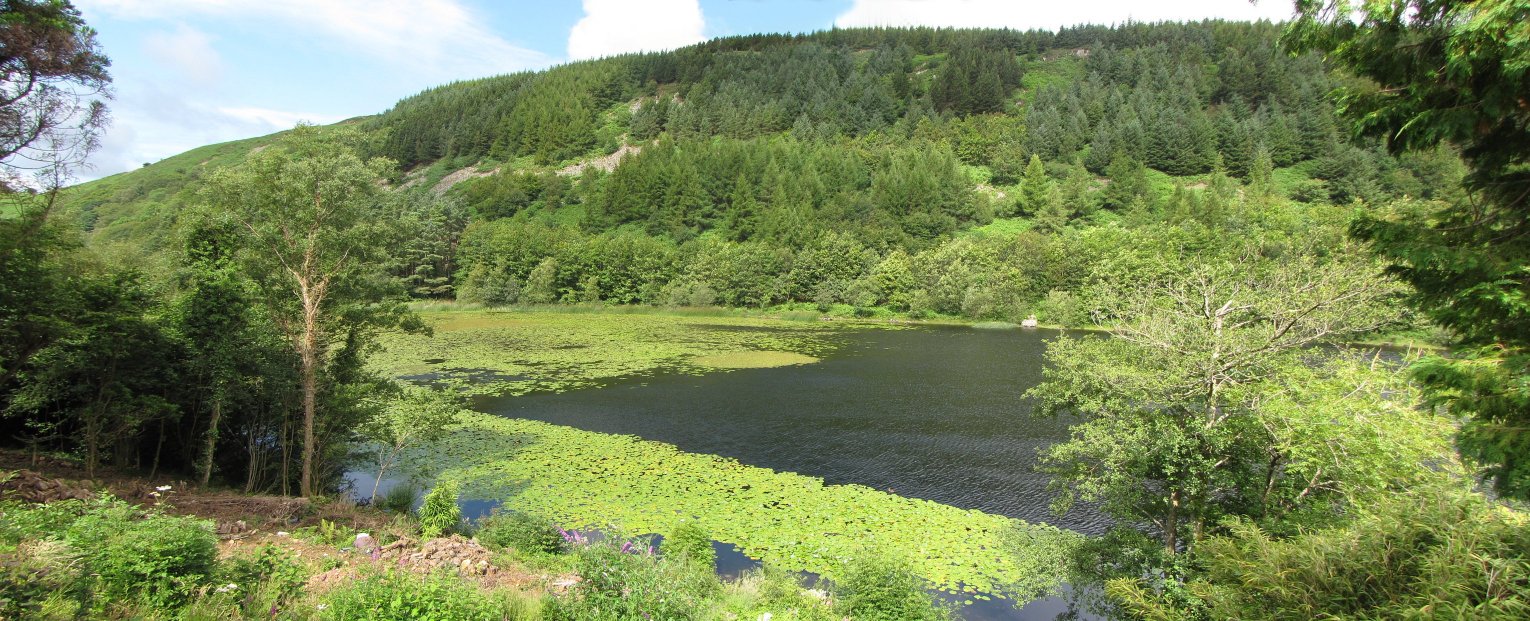
Llyn Gwernan

Llyn Gwernan is a lake in Gwynedd, Wales and an important geological site, notable for an unusual thickness of Devensian Late-glacial organic deposits...

Nearby Amenities

Located within 500m of 52.705,-3.924
Tourism: viewpoint
Lat/Long: 52.7034803/-3.9267432
Cyfrwy
Alt Name: The Saddle
Ele: 811
Natural: peak
Wikidata: Q5199173
Wikipedia: en:Cyfrwy
Lat/Long: 52.7022321/-3.9196537
The data included in this document is from www.openstreetmap.org. The data is made available under ODbL.

Have you been to Cadair Idris?

Leave your review of Cadair Idris below (or comments, questions and feedback).