Banna

Heritage Site in Cumberland Carlisle

England

Banna

Turf Wall and Vallum at High House, Hadrian's Wall Earthworks of the turf wall and vallum lie next to each other. Turf wall on right and vallum on the left.
Turf Wall and Vallum at High House, Hadrian's Wall Credit: Sandy Gerrard

Banna, Cumberland is a heritage site located in the county of Cumberland in the northwest region of England. It holds significant historical and cultural importance as it was once the site of a Roman fort known as Banna or Banna Victrix.

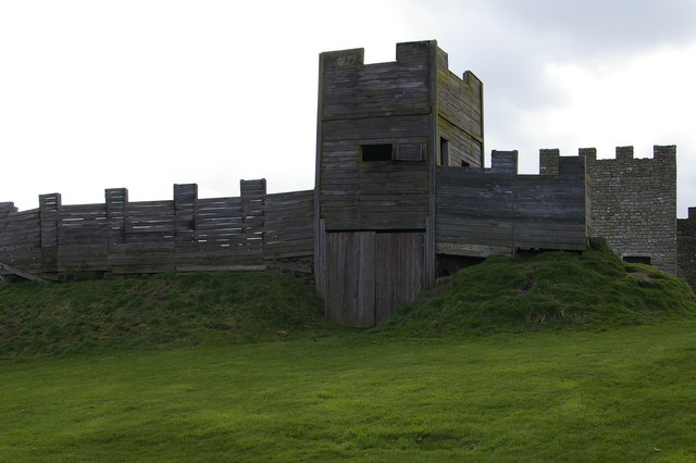
The fort was constructed around AD 74-75 and was an important strategic outpost along the Roman frontier, known as Hadrian's Wall. It served as a base for the Roman army and housed soldiers from various parts of the Roman Empire. The location of the fort was strategically chosen as it commanded a view of the surrounding landscape and controlled access to the strategic route between Carlisle and Hexham.

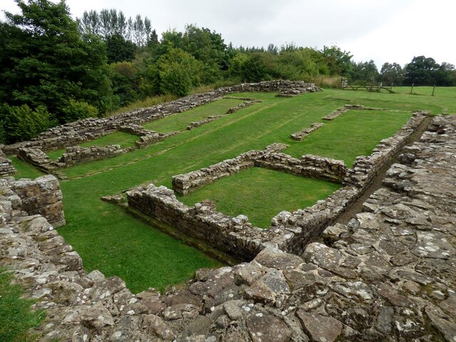
The remains of the fort consist of well-preserved earthworks and defensive structures, including a stone fort wall and gateways. Excavations have also uncovered several buildings within the fort, including barracks, granaries, and a headquarters building. These structures provide valuable insights into the daily life of Roman soldiers and their interactions with the local population.

Banna, Cumberland is a popular destination for history enthusiasts and tourists interested in Roman history. Visitors can explore the remains of the fort, walk along sections of Hadrian's Wall, and learn about the Roman occupation of Britain through informative displays and exhibitions. The site also offers guided tours and educational programs for schools and groups.

Overall, Banna, Cumberland is a significant heritage site that preserves and showcases the rich history of Roman Britain. It provides a glimpse into the lives of the Roman soldiers stationed on Hadrian's Wall and their impact on the local communities.

If you have any feedback on the listing, please let us know in the comments section below.

Banna Images

Images are sourced within 2km of 54.992/-2.602 or Grid Reference NY6166. Thanks to Geograph Open Source API. All images are credited.

Turf Wall and Vallum at High House, Hadrian's Wall Earthworks of the turf wall and vallum lie next to each other. Turf wall on right and vallum on the left.
Turf Wall and Vallum at High House, Hadrian's Wall
Earthworks of the turf wall and vallum lie next to each other. Turf wall on right and vallum on the left.
Birdoswald West, Turret 49b on Hadrian's Wall This turret replaced an earlier one on the nearby turf wall.
Birdoswald West, Turret 49b on Hadrian's Wall
This turret replaced an earlier one on the nearby turf wall.
Eastern Gate at Birdoswald Roman Fort Similar angle but more than 40 years later than <a href="https://www.geograph.org.uk/photo/6747428">NY6166 : Eastern Gate at Birdoswald Roman Fort</a>. The tree behind the gateway is now much smaller than it was in the 1970's.
Eastern Gate at Birdoswald Roman Fort
Similar angle but more than 40 years later than NY6166 : Eastern Gate at Birdoswald Roman Fort. The tree behind the gateway is now much smaller than it was in the 1970's.
Footbridge over the River Irthing View from the north.
Footbridge over the River Irthing
View from the north.
Roman bridge abutment at Willowford Hadrian's Wall was carried over the River Irthing at this point.
Roman bridge abutment at Willowford
Hadrian's Wall was carried over the River Irthing at this point.
Inscribed Roman stone and plaque at Willowford Farm The stone would have been built into Hadrian's Wall to denote which cohurt had constructed this section of the wall.
Inscribed Roman stone and plaque at Willowford Farm
The stone would have been built into Hadrian's Wall to denote which cohurt had constructed this section of the wall.
Willowford West Turret 48b on Hadrian's Wall View from south west.
Willowford West Turret 48b on Hadrian's Wall
View from south west.
Hadrian's Wall at Willowford This section of the wall includes a length of narrow wall sitting on top of a broad wall foundation.  As the wall was being construction changes were incorporated into the original design. Here the planned broad wall was replaced by a narrower wall.  This would have saved time, effort and resources.
Hadrian's Wall at Willowford
This section of the wall includes a length of narrow wall sitting on top of a broad wall foundation. As the wall was being construction changes were incorporated into the original design. Here the planned broad wall was replaced by a narrower wall. This would have saved time, effort and resources.
Willowford East Turret 48a View from south west.
Willowford East Turret 48a
View from south west.
Poltross Burn Roman Milecastle Well preserved milecastle on Hadrian's Wall.
Poltross Burn Roman Milecastle
Well preserved milecastle on Hadrian's Wall.
View over Irthing Valley View South over Irthing Valley from Heather Bank Cottage
View over Irthing Valley
View South over Irthing Valley from Heather Bank Cottage
Path by the railway This closely fenced public footpath beside the Newcastle to Carlisle Railway is part of The Hadrian's Wall Path National Trail.
Part of the remains of Poltross Burn Milecastle on the Roman Wall can be discerned in the background.
Path by the railway
This closely fenced public footpath beside the Newcastle to Carlisle Railway is part of The Hadrian's Wall Path National Trail. Part of the remains of Poltross Burn Milecastle on the Roman Wall can be discerned in the background.
Harrows Scar Milecastle Harrows Scar Milecastle, officially numbered Milecastle 49 on Hadrian’s Wall, is a scheduled ancient monument and stands at the top of a steep escarpment above the Irthing Valley.
The site is bisected by the track that leads to Underheugh Farm which is also the Hadrian’s Wall Path National Trail.
Harrows Scar Milecastle
Harrows Scar Milecastle, officially numbered Milecastle 49 on Hadrian’s Wall, is a scheduled ancient monument and stands at the top of a steep escarpment above the Irthing Valley. The site is bisected by the track that leads to Underheugh Farm which is also the Hadrian’s Wall Path National Trail.
Gateway to field and woodland with footpath to Denton Mains
View of train over field gate on south side of road south of Denton Mains The train is a Northern Carlisle to Newcastle service using Class 156/0 Super Sprinter number 156447.  The notice on the gate  advises Network Rail personnel that they would be trespassing without prior permission to access the railway from here.
View of train over field gate on south side of road south of Denton Mains
The train is a Northern Carlisle to Newcastle service using Class 156/0 Super Sprinter number 156447. The notice on the gate advises Network Rail personnel that they would be trespassing without prior permission to access the railway from here.
Drinking troughs Fed by a spring that emerges from the rear wall. Excess water flows into the nearby Harrow's Beck.
Drinking troughs
Fed by a spring that emerges from the rear wall. Excess water flows into the nearby Harrow's Beck.
Drainage through the Roman Wall
Along Hadrian's Wall Hadrian's Wall must have been a striking feature in its day. Although much degraded now, it's still worth a visit.
Along Hadrian's Wall
Hadrian's Wall must have been a striking feature in its day. Although much degraded now, it's still worth a visit.
Show me another place!

Banna is located at Grid Ref: NY6166 (Lat: 54.992, Lng: -2.602)

Administrative County: Cumbria

District: Carlisle

Police Authority: Cumbria

What 3 Words

///pity.dwarf.thrashing. Near Greenhead, Northumberland

Nearby Locations

Banna Chapel Field

Related Wikis

Nearby Amenities

Located within 500m of 54.992,-2.602
Birdoswald Roman Fort and Study Centre
Addr City: Gilsland
Addr Postcode: CA8 7DD
Fee: yes
Museum: history
Tourism: museum
Website: https://www.english-heritage.org.uk/visit/places/birdoswald-roman-fort-hadrians-wall
Lat/Long: 54.9900125/-2.6029565
Tourism: picnic_site
Lat/Long: 54.9881603/-2.6017178
Milecastle
Historic: ruins
Lat/Long: 54.9907675/-2.5950297
Bus Stop
Birdoswald Visitor Centre
Bench: no
Bin: no
Local Ref: AT
Naptan AtcoCode: 090033064236
Naptan Bearing: W
Naptan CommonName: Birdoswald Visitor Centre
Naptan Indicator: at
Naptan Landmark: Birdoswald Roman Fort
Naptan NaptanCode: cumdpwmt
Naptan Street: Military Road
Naptan Verified: no
Shelter: no
Source: naptan_import
Tactile Paving: no
Lat/Long: 54.9901802/-2.6031367
Bus Stop
Birdoswald Roman Fort Car Park
Bench: no
Bin: no
Local Ref: AT
Naptan AtcoCode: 090033411556
Naptan Bearing: S
Naptan CommonName: Birdoswald Roman Fort Car Park
Naptan Indicator: at
Naptan Landmark: Car Park for Birdoswald Roman Fort
Naptan NaptanCode: cumatgjt
Naptan Street: No name
Naptan Verified: no
Shelter: no
Source: naptan_import
Tactile Paving: no
Lat/Long: 54.9915118/-2.6009842
Bicycle Parking
Access: yes
Bicycle Parking: lockers
Capacity: 2
Covered: yes
Fee: no
Lat/Long: 54.9913788/-2.6008577
Information: guidepost
Tourism: information
Lat/Long: 54.9919268/-2.6009163
Toilets
Changing Table: yes
Changing Table Count: 1
Changing Table Location: unisex_toilet
Fee: no
Operator: English Heritage
Unisex: yes
Wheelchair: yes
Lat/Long: 54.990104/-2.6032273
Roman Altar
Historic: archaeological_site
Source: NLS-OS-1st_Series
Lat/Long: 54.9894154/-2.5980136
Milecastle 49
Historic: archaeological_site
Source: NLS-OS-1st_Series
Wikidata: Q16156627
Wikipedia: en:Milecastle 49
Lat/Long: 54.9907259/-2.5951555
Power: pole
Lat/Long: 54.9902832/-2.6035727
Power: pole
Lat/Long: 54.9911587/-2.6036921
Power: pole
Lat/Long: 54.9924632/-2.6038363
Power: pole
Lat/Long: 54.9936164/-2.6040114
Power: pole
Lat/Long: 54.9947294/-2.6041226
Power: pole
Lat/Long: 54.9957667/-2.6042688
The data included in this document is from www.openstreetmap.org. The data is made available under ODbL.

Have you been to Banna ?

Leave your review of Banna below (or comments, questions and feedback).