2 Willow Road

Heritage Site in Middlesex

England

2 Willow Road

UCL Academy, Adelaide Road, London NW3 UCL Academy, under construction. View from Avenue Road.
UCL Academy, Adelaide Road, London NW3 Credit: moska

2 Willow Road is a 20th-century modernist house located in Hampstead, Middlesex, now part of the London Borough of Camden. Designed by the renowned architect Ernő Goldfinger, the house was completed in 1939 and is now recognized as a heritage site. It stands as a striking example of the International Style of architecture.

The house is a three-story structure, built with a reinforced concrete frame and brick infill. Its exterior features a smooth white render, which contrasts with the surrounding red-brick houses in the area. The design incorporates large, floor-to-ceiling windows that flood the interior with natural light and create a seamless connection between the indoor and outdoor spaces.

Inside, 2 Willow Road showcases a minimalist and functional layout. The ground floor comprises a kitchen, dining room, and living area, while the upper floors house the bedrooms and private spaces. The rooms are characterized by clean lines, white-painted walls, and built-in furniture, reflecting Goldfinger's belief in the importance of efficient design.

The house also incorporates various innovative features for its time, such as underfloor heating, concealed lighting, and a central ventilation system. These elements highlight Goldfinger's commitment to embracing modern technology and materials.

Today, 2 Willow Road is managed by the National Trust and offers guided tours to the public. Visitors have the opportunity to explore the well-preserved interior and learn about Goldfinger's architectural vision. The house stands as a testament to the development of modernist architecture in Britain and provides insight into the lives of its former residents.

If you have any feedback on the listing, please let us know in the comments section below.

2 Willow Road Images

Images are sourced within 2km of 51.557/-0.169 or Grid Reference TQ2785. Thanks to Geograph Open Source API. All images are credited.

UCL Academy, Adelaide Road, London NW3 UCL Academy, under construction. View from Avenue Road.
UCL Academy, Adelaide Road, London NW3
UCL Academy, under construction. View from Avenue Road.
West Hampstead Station The overground station, one of three (Thameslink, Overground and Jubilee Line) separate but adjacent rail stations in the area. The train here is heading west towards Richmond.
West Hampstead Station
The overground station, one of three (Thameslink, Overground and Jubilee Line) separate but adjacent rail stations in the area. The train here is heading west towards Richmond.
West Hampstead Thameslink railway station An East Midands Railway service approaches West Hampstead Thameslink station on a service from London to Nottingham.
West Hampstead Thameslink railway station
An East Midands Railway service approaches West Hampstead Thameslink station on a service from London to Nottingham.
The North London Line, east of Hampstead Heath station Seen from the footbridge giving access to Parliament Hill from Savernake Road.   The view is eastward - next stop Gospel Oak.
The North London Line, east of Hampstead Heath station
Seen from the footbridge giving access to Parliament Hill from Savernake Road. The view is eastward - next stop Gospel Oak.
Nassington Road, Hampstead NW3 Leading downhill towards Parliament Hill Fields.
Nassington Road, Hampstead NW3
Leading downhill towards Parliament Hill Fields.
Gospel Oak Overground station, view ENE With railway stations I'm always looking for traces of their early history.  In this instance I was disappointed,

Mansfield Road - which soon becomes Gordon House Road - leads towards Highgate Road and Kentish Town.
Gospel Oak Overground station, view ENE
With railway stations I'm always looking for traces of their early history. In this instance I was disappointed, Mansfield Road - which soon becomes Gordon House Road - leads towards Highgate Road and Kentish Town.
Boscastle Road, Parliament Hill, NW5 Big, solid - and charmless - Victorian houses.

The view is south-east toward Dartmouth Park Road, from the corner of Woodsome Road.
Boscastle Road, Parliament Hill, NW5
Big, solid - and charmless - Victorian houses. The view is south-east toward Dartmouth Park Road, from the corner of Woodsome Road.
Croftdown Road, Parliament Hill, London NW5 View downhill and north-eastwards.
Croftdown Road, Parliament Hill, London NW5
View downhill and north-eastwards.
Hampstead Heath : Kenwood House Kenwood House, remodelled by architect Robert Adam, is a Grade I listed building on the northern edge of Hampstead Heath. Description at this <span class="nowrap"><a title="https://historicengland.org.uk/listing/the-list/list-entry/1379242" rel="nofollow ugc noopener" href="https://historicengland.org.uk/listing/the-list/list-entry/1379242">Link</a><img style="margin-left:2px;" alt="External link" title="External link - shift click to open in new window" src="https://s1.geograph.org.uk/img/external.png" width="10" height="10"/></span>.
Hampstead Heath : Kenwood House
Kenwood House, remodelled by architect Robert Adam, is a Grade I listed building on the northern edge of Hampstead Heath. Description at this LinkExternal link.
Hampstead Heath : Henry Moore sculpture Two Piece Reclining Figure No.5 (1963-1964). <span class="nowrap"><a title="https://www.tate.org.uk/whats-on/tate-britain/exhibition/henry-moore/henry-moore-room-guide/henry-moore-moore-outside-1" rel="nofollow ugc noopener" href="https://www.tate.org.uk/whats-on/tate-britain/exhibition/henry-moore/henry-moore-room-guide/henry-moore-moore-outside-1">Link</a><img style="margin-left:2px;" alt="External link" title="External link - shift click to open in new window" src="https://s1.geograph.org.uk/img/external.png" width="10" height="10"/></span>.
Hampstead Heath : Henry Moore sculpture
Two Piece Reclining Figure No.5 (1963-1964). LinkExternal link.
Hampstead Heath : verandah detail, Kenwood House Features a pair of cast iron openwork Ionic pillars. Kenwood House, remodelled by architect Robert Adam, is a Grade I listed building on the northern edge of Hampstead Heath. Description at this <span class="nowrap"><a title="https://historicengland.org.uk/listing/the-list/list-entry/1379242" rel="nofollow ugc noopener" href="https://historicengland.org.uk/listing/the-list/list-entry/1379242">Link</a><img style="margin-left:2px;" alt="External link" title="External link - shift click to open in new window" src="https://s1.geograph.org.uk/img/external.png" width="10" height="10"/></span>.
Hampstead Heath : verandah detail, Kenwood House
Features a pair of cast iron openwork Ionic pillars. Kenwood House, remodelled by architect Robert Adam, is a Grade I listed building on the northern edge of Hampstead Heath. Description at this LinkExternal link.
Hampstead Heath : verandah detail, Kenwood House Kenwood House, remodelled by architect Robert Adam, is a Grade I listed building on the northern edge of Hampstead Heath. Description at this <span class="nowrap"><a title="https://historicengland.org.uk/listing/the-list/list-entry/1379242" rel="nofollow ugc noopener" href="https://historicengland.org.uk/listing/the-list/list-entry/1379242">Link</a><img style="margin-left:2px;" alt="External link" title="External link - shift click to open in new window" src="https://s1.geograph.org.uk/img/external.png" width="10" height="10"/></span>.
Hampstead Heath : verandah detail, Kenwood House
Kenwood House, remodelled by architect Robert Adam, is a Grade I listed building on the northern edge of Hampstead Heath. Description at this LinkExternal link.
Hampstead Heath : sham bridge south of Kenwood House Grade II* list sham bridge, c 1767 by Robert Adam. <span class="nowrap"><a title="https://historicengland.org.uk/listing/the-list/list-entry/1379245" rel="nofollow ugc noopener" href="https://historicengland.org.uk/listing/the-list/list-entry/1379245">Link</a><img style="margin-left:2px;" alt="External link" title="External link - shift click to open in new window" src="https://s1.geograph.org.uk/img/external.png" width="10" height="10"/></span>.
Hampstead Heath : sham bridge south of Kenwood House
Grade II* list sham bridge, c 1767 by Robert Adam. LinkExternal link.
Hampstead Heath : stone bridge at Wood Pond
Steam at Camden Shed – 1960 The interest of this picture is that it shows the unique British Railways standard Class 8 pacific 71000 'Duke of Gloucester' in the centre. Due to dieselisation it was the only one of the type built and it also suffered from heavy fuel consumption. It has however survived into preservation and is currently (2021) based at Tyseley <a title="https://www.geograph.org.uk/photo/1617355" href="https://www.geograph.org.uk/photo/1617355">Link</a> . Modifications since preservation have dramatically improved its steaming capabilities, and during trials in 1995 it significantly outperformed a 'Duchess' pacific similar to 46257 seen alongside.

46257 "City of Salford" is one of the final two of the class built, with modified trailing axle and roller bearings. The type 4 diesel locomotive to the right shows that the conversion to diesel operation on the West Coast Main Line was already well under way.
Steam at Camden Shed – 1960
The interest of this picture is that it shows the unique British Railways standard Class 8 pacific 71000 'Duke of Gloucester' in the centre. Due to dieselisation it was the only one of the type built and it also suffered from heavy fuel consumption. It has however survived into preservation and is currently (2021) based at Tyseley Link . Modifications since preservation have dramatically improved its steaming capabilities, and during trials in 1995 it significantly outperformed a 'Duchess' pacific similar to 46257 seen alongside. 46257 "City of Salford" is one of the final two of the class built, with modified trailing axle and roller bearings. The type 4 diesel locomotive to the right shows that the conversion to diesel operation on the West Coast Main Line was already well under way.
By Whitestone Pond, Hampstead By West Heath Road
By Whitestone Pond, Hampstead
By West Heath Road
Show me another place!

2 Willow Road is located at Grid Ref: TQ2785 (Lat: 51.557, Lng: -0.169)

Unitary Authority: Camden

Police Authority: Metropolitan

What 3 Words

///speech.native.yard. Near Belsize Park, London

Related Wikis

2 Willow Road

2 Willow Road is part of a terrace of three houses in Hampstead, London designed by architect Ernő Goldfinger and completed in 1939. It has been managed...
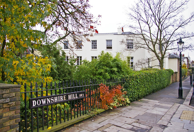
Downshire Hill

Downshire Hill is a street in Hampstead, London, in the London Borough of Camden. The street has always been a preferred residential address, in which...

St John's Downshire Hill

St John's Downshire Hill, Hampstead, is a proprietary chapel of the Church of England, located in Downshire Hill, Hampstead, London, in the Parish of St...

Keats House

Keats House is a writer's house museum in what was once the home of the Romantic poet John Keats. It is in Keats Grove, Hampstead, toward the edge of inner...

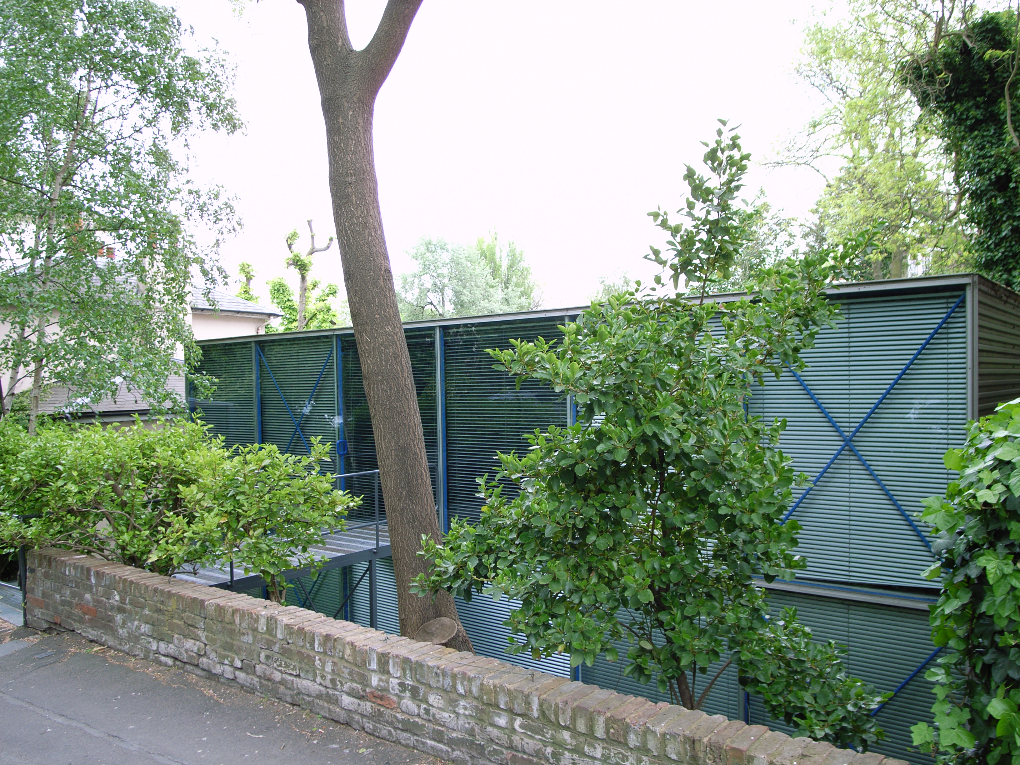
Hopkins House, Hampstead

The Hopkins House at 49a Downshire Hill is the common name given to the high-tech home and workspace in Hampstead, London (1976), designed by architects...
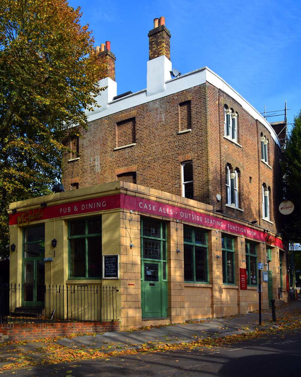
The Magdala

The Magdala, also known as The Magdala Tavern or colloquially as simply The Magy, is a pub on South Hill Park in Hampstead, north London. Named after the...

Hampstead and Highgate (UK Parliament constituency)

Hampstead & Highgate was a parliamentary constituency covering the northern half of the London Borough of Camden which includes the village of Hampstead...

Gainsborough Gardens

Gainsborough Gardens is a private road in Hampstead, in the London Borough of Camden. The road is arranged in an oval crescent around a central garden...

Nearby Amenities

Located within 500m of 51.557,-0.169
Created By: YahooApplet 1.0
Lat/Long: 51.5529925/-0.1676881
Entrance: main
Lat/Long: 51.5535991/-0.1662766
M&S Foodhall
Addr City: London
Addr Housenumber: 10
Addr Postcode: NW3 2PS
Addr Street: Pond Street
Brand: M&S Foodhall
Brand Wikidata: Q714491
Payment Cash: yes
Payment Mastercard: yes
Payment Visa: yes
Phone: +44 20 7435 0619
Shop: supermarket
Toilets Wheelchair: no
Website: https://www.marksandspencer.com/stores/hampstead-sf-7553
Wheelchair: yes
Lat/Long: 51.553926/-0.165233
Ref GB Tflcid: RWG002151
Traffic Calming: hump
Lat/Long: 51.5554073/-0.1755086
Post Box
Collection Times: Mo-Fr 09:00; Sa 07:00
Operator: Royal Mail
Post Box Type: pillar
Ref: NW3 55D
Royal Cypher: VR
Lat/Long: 51.557253/-0.1697021
Post Box
Lat/Long: 51.5586572/-0.1739503
Post Box
Post Box Type: pillar
Ref: NW3 36
Royal Cypher: EVIIR
Royal Cypher Wikidata: Q33102324
Lat/Long: 51.5599409/-0.1724048
Crossing
Crossing: uncontrolled
Crossing Ref: zebra
Ref GB Tflcid: RWG039786
Traffic Calming: hump
Lat/Long: 51.5599654/-0.1722145
Bus Stop
Pilgrim's Lane
Bench: yes
Bin: no
Bus: yes
Check Date Shelter: 2023-02-07
Lit: yes
Local Ref: A
Naptan AtcoCode: 490011000N
Naptan Bearing: N
Naptan CommonName: Pilgrim's Lane
Naptan Indicator: Stop A
Naptan Street: ROSSLYN HILL
Public Transport: platform
Ref: 75822
Shelter: yes
Source Ref: naptan
Tactile Paving: no
Lat/Long: 51.5546932/-0.1725342
Bus Stop
Pilgrim's Lane
Bench: yes
Bus: yes
Local Ref: S
Naptan AtcoCode: 490011000S
Naptan Bearing: S
Naptan CommonName: Pilgrim's Lane
Naptan Indicator: Stop S
Naptan Street: ROSSLYN HILL
Naptan Verified: no
Public Transport: platform
Ref: 49569
Shelter: yes
Source Ref: naptan
Lat/Long: 51.5549455/-0.1728904
Bus Stop
Royal Free Hospital
Bench: yes
Bin: yes
Bus: yes
Lit: yes
Local Ref: C
Naptan AtcoCode: 490011760C
Naptan Bearing: N
Naptan CommonName: Royal Free Hospital Pond St
Naptan Indicator: Stop C
Naptan Street: POND STREET
Public Transport: platform
Ref: 72110
Shelter: yes
Source Ref: naptan
Tactile Paving: no
Lat/Long: 51.5538624/-0.166811
Bus Stop
Royal Free Hospital
Bench: yes
Bin: yes
Bus: yes
Lit: yes
Local Ref: D
Naptan AtcoCode: 490011760D
Naptan Bearing: N
Naptan CommonName: Royal Free Hospital Pond St
Naptan Indicator: Stop D
Naptan Street: POND STREET
Public Transport: platform
Ref: 72282
Shelter: yes
Source Ref: naptan
Lat/Long: 51.5539875/-0.1655126
Bus Stop
Royal Free Hospital
Bus: yes
Local Ref: Z
Naptan AtcoCode: 490011760W
Naptan Bearing: W
Naptan CommonName: Royal Free Hospital Pond St
Naptan Street: FLEET ROAD
Naptan Verified: no
Note: Alighting point only.
Public Transport: platform
Ref: 47056
Source Ref: naptan
Lat/Long: 51.5539869/-0.164728
Bus Stop
Rosslyn Hill
Bench: yes
Bin: no
Bus: yes
Local Ref: E
Naptan AtcoCode: 490011714E
Naptan Bearing: N
Naptan CommonName: Rosslyn Hill
Naptan Indicator: E
Public Transport: platform
Ref: 73825
Shelter: yes
Source Ref: naptan
Lat/Long: 51.5533483/-0.1684451
Bus Stop
South End Green
Bus: yes
Local Ref: A
Naptan AtcoCode: 490012280A
Naptan Bearing: N
Naptan CommonName: South End Green
Naptan Indicator: A
Naptan Street: SOUTH END GREEN
Naptan Verified: yes
Public Transport: platform
Ref: 72787
Source Ref: naptan
Lat/Long: 51.5543891/-0.164803
Bus Stop
South End Green
Bus: yes
Local Ref: B
Naptan AtcoCode: 490012280B
Naptan Bearing: N
Naptan CommonName: South End Green
Naptan Indicator: B
Naptan Street: CONSTANTINE ROAD
Public Transport: platform
Ref: 55391
Source Ref: naptan
Lat/Long: 51.5542815/-0.1645847
Bus Stop
South End Green
Bench: no
Bus: yes
Local Ref: X
Naptan AtcoCode: 490012280N
Naptan Bearing: N
Naptan CommonName: South End Green
Naptan Street: SOUTH END ROAD
Naptan Verified: no
Public Transport: platform
Ref: 51130
Shelter: no
Lat/Long: 51.5543378/-0.1657043
Bus Stop
Rosslyn Hill
Bench: yes
Bin: yes
Bus: yes
Lit: yes
Local Ref: G
Naptan AtcoCode: 490015255G
Naptan Bearing: N
Naptan CommonName: Rosslyn Hill Pond Street
Naptan Indicator: Stop G
Public Transport: platform
Ref: 56866
Shelter: yes
Source Ref: naptan
Tactile Paving: no
Wheelchair: yes
Lat/Long: 51.5527771/-0.1684996
South End Green
Bus: yes
Local Ref: A
Public Transport: stop_position
Lat/Long: 51.5543508/-0.1648297
Post Box
Operator: Royal Mail
Operator Wikidata: Q638098
Post Box Type: pillar
Ref: NW3 4
Royal Cypher: EIIR
Royal Cypher Wikidata: Q33102113
Lat/Long: 51.5546803/-0.1727319
Post Box
Operator: Royal Mail
Operator Wikidata: Q638098
Post Box Type: pillar
Ref: NW3 51
Royal Cypher: VR
Royal Cypher Wikidata: Q33102356
Lat/Long: 51.5544011/-0.1689799
Post Box
Collection Times: Mo-Fr 09:00, Sa 07:00
Operator: Royal Mail
Operator Wikidata: Q638098
Ref: NW3 7
Royal Cypher: VR
Royal Cypher Wikidata: Q33102356
Lat/Long: 51.553094/-0.170978
Addr City: London
Addr Country: GB
Addr Housenumber: 154-156
Addr Street: Fleet Road
Check Date: 2022-04-30
Disused Amenity: pub
Old Name: Cork & Bottle Hampstead
Toilets: yes
Toilets Access: customers
Wheelchair: no
Lat/Long: 51.554133/-0.164588
Pub
The Magdala
Addr City: London
Addr Housenumber: 2a
Addr Postcode: NW3 2SB
Addr Street: South Hill Park
Contact Phone: +44 20 7435 2503
Contact Website: http://www.the-magdala.com/
Indoor Seating: yes
Outdoor Seating: yes
Wikidata: Q18162256
Lat/Long: 51.5555828/-0.1656213
Restaurant
Dar's
Cuisine: indian
Phone: +44 20 7485 9921
Takeaway: yes
Lat/Long: 51.5543584/-0.1645522
Barrier: entrance
Bicycle: yes
Foot: yes
Motorcar: yes
Motorcycle: yes
Lat/Long: 51.5545824/-0.1653062
Handscomb of Hampstead
Shop: greengrocer
Lat/Long: 51.5551816/-0.1660041
Crossing
Crossing: uncontrolled
Crossing Island: no
Crossing Ref: zebra
Tactile Paving: yes
Lat/Long: 51.5535555/-0.1679366
Crossing
Crossing: uncontrolled
Crossing Island: no
Crossing Ref: zebra
Kerb: lowered
Tactile Paving: yes
Lat/Long: 51.5540119/-0.1656602
Telephone
Booth: KX100
Check Date: 2024-03-19
Covered: booth
Operator: BT
Payment Coins: yes
Payment Credit Cards: yes
Payment Debit Cards: yes
Lat/Long: 51.5548924/-0.1658235
Cafe
Matchbox Cafe
Addr Housenumber: 1a
Addr Street: Elm Terrace
Contact Phone: +44 20 7267 7788
Lat/Long: 51.5544338/-0.1647213
Telephone
Booth: K2
Covered: booth
Listed Status: Grade II
Wikidata: Q27086145
Lat/Long: 51.5541216/-0.1654128
Ham&High
Addr Housenumber: 1
Addr Street: Elm Terrace
Shop: newsagent
Lat/Long: 51.5543418/-0.1647221
Recycling
Lat/Long: 51.554408/-0.1650487
Amberden Estates
Addr City: London
Addr Housenumber: 6
Addr Postcode: NW3 2SB
Addr Street: South Hill Park
Contact Phone: +44 20 7433 3310
Contact Website: http://www.amberden.co.uk/
Shop: estate_agent
Lat/Long: 51.5556786/-0.1654936
L'Amel Hairdressing
Addr City: London
Addr Housenumber: 4
Addr Postcode: NW3 2SB
Addr Street: South Hill Park
Shop: hairdresser
Lat/Long: 51.5556234/-0.1655454
Addr Housenumber: 8
Lat/Long: 51.5557384/-0.1654862
Addr Housenumber: 14
Lat/Long: 51.5559807/-0.1654591
Hamstead Supermarket & Off License
Shop: convenience
Lat/Long: 51.5543883/-0.1644521
Hamstead Orthodentic Practice
Lat/Long: 51.5544052/-0.1643961
Crossing
Crossing: uncontrolled
Crossing Ref: zebra
Tactile Paving: yes
Lat/Long: 51.5541948/-0.1649092
Heath Shoe Clinic
Addr Housenumber: 87
Phone: +44 20 7435 7121
Lat/Long: 51.5540405/-0.1650022
Shop: vacant
Lat/Long: 51.5539973/-0.1643591
Cafe
Giacobazzi's
Addr Housenumber: 150
Lat/Long: 51.553979/-0.1642734
Crossing
Crossing: uncontrolled
Crossing Ref: zebra
Tactile Paving: yes
Lat/Long: 51.5541448/-0.164801
Cafe
Zamazingo
Outdoor Seating: yes
Lat/Long: 51.553957/-0.164871
Dentist
heath health care
Lat/Long: 51.5544215/-0.1643267
elisabeth jay
Addr Housenumber: 148
Phone: +44 20 7485 3039
Shop: beauty
Lat/Long: 51.5539607/-0.1641924
Newman & Son
Addr Housenumber: 4
Shop: locksmith
Lat/Long: 51.554181/-0.1643643
Post Box
Ref: NW3 15
Lat/Long: 51.5565212/-0.1736557
Restaurant
The Little Thai
Cuisine: thai
Outdoor Seating: no
Takeaway: yes
Wheelchair: no
Lat/Long: 51.553868/-0.164596
Crossing
Crossing: uncontrolled
Crossing Ref: zebra
Kerb: lowered
Tactile Paving: yes
Lat/Long: 51.5535172/-0.1670196
Ref GB Tflcid: RWG002141
Traffic Calming: hump
Lat/Long: 51.5552397/-0.1747139
Property Divas
Addr Housenumber: 34A
Addr Street: Rosslyn Hill
Shop: estate_agent
Lat/Long: 51.5547293/-0.172214
Bench
Backrest: yes
Lat/Long: 51.5544631/-0.1716982
Crossing
Crossing: uncontrolled
Crossing Ref: zebra
Tactile Paving: yes
Lat/Long: 51.5541365/-0.1649091
Crossing
Crossing: unmarked
Crossing Island: yes
Tactile Paving: yes
Lat/Long: 51.5542879/-0.1651964
Crossing
Crossing: uncontrolled
Crossing Island: yes
Crossing Ref: zebra
Tactile Paving: yes
Lat/Long: 51.5545398/-0.1657043
Crossing
Lat/Long: 51.5551677/-0.1739976
Telephone
Booth: K6
Covered: booth
Listed Status: Grade II
Wikidata: Q26423503
Lat/Long: 51.5544484/-0.1716681
Crossing
Check Date Crossing: 2023-02-07
Crossing: unmarked
Tactile Paving: yes
Lat/Long: 51.5540985/-0.1655152
Turning Circle
Lat/Long: 51.5552726/-0.1623876
Bench
Backrest: no
Lat/Long: 51.5551668/-0.1653269
Bench
Backrest: yes
Lat/Long: 51.5552612/-0.1656285
Bench
Backrest: yes
Lat/Long: 51.5551129/-0.1654445
Crossing
Crossing: uncontrolled
Crossing Island: yes
Crossing Ref: zebra
Tactile Paving: yes
Lat/Long: 51.5551708/-0.16618
Entrance: yes
Lat/Long: 51.5552519/-0.165872
Bench
Backrest: yes
Lat/Long: 51.5552662/-0.1656017
Bicycle Parking
Bicycle Parking: stands
Capacity: 4
Check Date: 2022-04-30
Covered: yes
Lat/Long: 51.5553468/-0.1651865
Bench
Backrest: yes
Lat/Long: 51.5551091/-0.165496
Entrance: yes
Lat/Long: 51.5552284/-0.1659333
Bench
Backrest: no
Lat/Long: 51.5553109/-0.1652879
Telephone
Booth: K6
Covered: booth
Listed Status: Grade II
Operator: British Telecom
Wikidata: Q26406914
Lat/Long: 51.5575452/-0.1757193
Telephone
Booth: K6
Covered: booth
Listed Status: Grade II
Operator: British Telecom
Wikidata: Q26406914
Lat/Long: 51.5575569/-0.1757294
Telephone
Booth: K6
Check Date: 2023-02-07
Covered: booth
Lat/Long: 51.5548655/-0.1728179
Bicycle Parking
1
Bicycle Parking: stands
Capacity: 2
Check Date: 2023-02-07
Covered: no
Lat/Long: 51.5548758/-0.172863
Bench
Backrest: yes
Lat/Long: 51.5549105/-0.1729853
Waste Basket
Lat/Long: 51.5554233/-0.1707705
Bench
Lat/Long: 51.5554441/-0.1707424
Drinking Water
East Heath Road 2
Description: Fountain
Image: http://findafountain.org/system/101/original/uk-greater-london-london-hamstead-east-heath-road-2-outdoor-fountain.jpg
Maintenance: ok
Source: osmsync:findafountain
Source Pkey: 89
Lat/Long: 51.5575/-0.167614
Post Box
Post Box Type: wall
Ref: NW3 54
Royal Cypher: EIIR
Royal Cypher Wikidata: Q33102113
Lat/Long: 51.5570675/-0.1749767
Rosslyn Arms monthly exibitions
Tourism: artwork
Lat/Long: 51.5550218/-0.1731276
Entrance: main
Source: photograph
Lat/Long: 51.5555947/-0.1755435
Entrance: main
Source: photograph
Lat/Long: 51.5556097/-0.175616
Entrance: main
Source: photograph
Lat/Long: 51.5556298/-0.1757116
Entrance: yes
Source: photograph
Lat/Long: 51.5556408/-0.1757657
Entrance: main
Source: photograph
Lat/Long: 51.5556491/-0.1758063
Post Box
Check Date: 2022-04-30
Collection Times: Mo-Fr 09:00; Sa 07:00
Operator: Royal Mail
Operator Wikidata: Q638098
Ref: NW3 47D
Royal Cypher: VR
Royal Cypher Wikidata: Q33102356
Lat/Long: 51.5557895/-0.1652118
Waste Basket
Waste: trash
Lat/Long: 51.5595101/-0.166309
Waste Basket
Waste: dog_excrement
Lat/Long: 51.5595264/-0.1662885
Life Ring
Emergency: life_ring
Lat/Long: 51.5584174/-0.1659435
Life Ring
Emergency: life_ring
Lat/Long: 51.5594388/-0.1662102
Life Ring
Emergency: life_ring
Lat/Long: 51.5597251/-0.1653347
Hampstead Heath
Public Transport: stop_position
Railway: stop
Ref: 1
Train: yes
Lat/Long: 51.5550799/-0.1659509
Hampstead Heath
Public Transport: stop_position
Railway: stop
Ref: 2
Train: yes
Lat/Long: 51.5553507/-0.1649882
Waste Basket
Check Date: 2022-04-30
Lat/Long: 51.5553405/-0.1662251
Bicycle Parking
Bicycle Parking: stands
Capacity: 1
Check Date: 2022-04-30
Covered: no
Lat/Long: 51.5551549/-0.1663862
Bicycle Parking
Bicycle Parking: stands
Capacity: 1
Covered: no
Lat/Long: 51.5550635/-0.1660175
Bicycle Parking
Bicycle Parking: stands
Capacity: 2
Check Date: 2022-04-30
Covered: no
Lat/Long: 51.5550736/-0.1662237
Crossing
Crossing: uncontrolled
Crossing Island: no
Crossing Ref: zebra
Lat/Long: 51.5576039/-0.1680239
Post Box
Operator: Royal Mail
Operator Wikidata: Q638098
Post Box Type: pillar
Ref: NW3 34D
Lat/Long: 51.5589399/-0.1637079
Post Box
Check Date: 2022-04-30
Post Box Type: pillar
Lat/Long: 51.5558916/-0.1667493
2 Willow Road
Addr City: London
Addr Housenumber: 2
Addr Postcode: NW3 1TH
Addr Street: Willow Road
Description: This Modernist home was designed by architect Ernö Goldfinger in 1939 for himself and his family.
Operator: National Trust
Tourism: museum
Website: https://www.nationaltrust.org.uk/visit/london/2-willow-road
Wikidata: Q222881
Lat/Long: 51.5571646/-0.1691747
Addr Housenumber: 1
Addr Street: Willow Road
Lat/Long: 51.5571685/-0.1690932
Addr Housenumber: 7
Addr Street: Willow Road
Lat/Long: 51.5572145/-0.1696425
Royal Free Hospital
Bus: yes
Local Ref: Z
Public Transport: stop_position
Lat/Long: 51.5540262/-0.1646992
Cycleway: asl
Direction: forward
Lat/Long: 51.5531965/-0.1694976
Traffic Signals
Traffic Signals Direction: backward
Lat/Long: 51.55336/-0.1694881
Ref GB Tflcid: RWG002145
Traffic Calming: hump
Lat/Long: 51.5553001/-0.1749741
Bicycle Parking
Bicycle Parking: stands
Capacity: 2
Lat/Long: 51.5573842/-0.1678223
Hampstead Heath (Mixed Pond)
Description: Bathing water quality monitoring point at Hampstead Heath (Mixed Pond)
Man Made: monitoring_station
Monitoring Bathing Water: yes
Operator: Environment Agency
Ref: 11930
Ref EU Bwid: uki1101-11930
Source: Environment Agency Open Data
Website: http://environment.data.gov.uk/bwq/profiles/profile.html?site=uki1101-11930
Lat/Long: 51.5607129/-0.16629
Cafe
Silverberry
Diet Vegetarian: yes
Indoor Seating: yes
Outdoor Seating: yes
Payment Credit Cards: yes
Payment Debit Cards: yes
Shop: deli
Lat/Long: 51.553992/-0.1650218
Barrier: bollard
Lat/Long: 51.5569107/-0.1671303
Crossing
Check Date Crossing: 2023-02-07
Crossing: uncontrolled
Crossing Ref: zebra
Kerb: lowered
Tactile Paving: yes
Lat/Long: 51.5536574/-0.1670983
Bicycle Parking
Bicycle Parking: stands
Check Date: 2024-03-19
Covered: no
Lat/Long: 51.5533835/-0.1670044
Crossing
Crossing: unmarked
Crossing Island: no
Tactile Paving: yes
Lat/Long: 51.5534731/-0.1671255
South End Green
Check Date: 2022-04-30
Information: map
Map Size: site
Map Type: street
Network: legible_london
Ref: 02128
Tourism: information
Lat/Long: 51.5542641/-0.1649485
Bench
Lat/Long: 51.5560479/-0.1638961
Grit Bin
Lat/Long: 51.5565773/-0.1630802
Bench
Lat/Long: 51.5561973/-0.1635882
Addr Housenumber: 40
Lat/Long: 51.5572686/-0.1624536
Parking Entrance
Lat/Long: 51.555955/-0.1636749
Bicycle Parking
Bicycle Parking: stands
Capacity: 2
Covered: no
Lat/Long: 51.5536458/-0.167492
Bicycle Parking
Bicycle Parking: stands
Capacity: 4
Covered: no
Lat/Long: 51.5536712/-0.1673986
Bench
Backrest: yes
Lat/Long: 51.5536131/-0.1673659
Bench
Backrest: yes
Lat/Long: 51.5535841/-0.1672445
Bench
Lat/Long: 51.5607164/-0.1674936
Bench
Backrest: yes
Lat/Long: 51.5577641/-0.1662672
Bench
Backrest: yes
Lat/Long: 51.5580429/-0.1660161
Bench
Backrest: yes
Lat/Long: 51.5583015/-0.1657555
Bench
Lat/Long: 51.558796/-0.1660659
Bench
Backrest: yes
Lat/Long: 51.5589247/-0.1661349
Bench
Lat/Long: 51.5590605/-0.1661618
The Sweet Pea
Shop: florist
Lat/Long: 51.5555491/-0.166695
Appi
Healthcare: physiotherapist
Lat/Long: 51.5552776/-0.1664839
Hampstead Heath
Naptan AtcoCode: 9100HMPSTDH
Network: National Rail
Network Website: https://www.nationalrail.co.uk/stations/hdh/
Network Wikidata: Q26334
Operator: London Overground
Public Transport: station
Railway: station
Ref Crs: HDH
Source: NPE
Source Network: Sign
Source Ref: http://en.wikipedia.org/wiki/List_of_London_railway_stations;http://en.wikipedia.org/wiki/London_Overground#Stations
Train: yes
Wheelchair: yes
Wheelchair Description: Access from platform to train by manual boarding ramp.
Wikidata: Q2829947
Wikipedia: en:Hampstead Heath railway station
Lat/Long: 51.5552396/-0.1653912
Arthur Bliss
Historic: memorial
Inscription: Arthur Bliss (1891–1975) Composer lived here 1929–1939
Memorial: blue_plaque
Openplaques Id: 66
Lat/Long: 51.5591025/-0.1707191
John Constable
Historic: memorial
Inscription: John Constable (1776–1837) Painter lived here
Memorial: blue_plaque
Openplaques Id: 165
Lat/Long: 51.5589848/-0.1734358
John Heartfield
Historic: memorial
Inscription: John Heartfield (1891–1968) Master of Political Photomontage lived here 1938–1943
Memorial: blue_plaque
Openplaques Id: 407
Lat/Long: 51.5554781/-0.1703254
Henry Mayers Hyndman
Historic: memorial
Inscription: Henry Mayers Hyndman (1842–1921) Socialist Leader lived and died here
Memorial: blue_plaque
Openplaques Id: 29
Lat/Long: 51.5591499/-0.1736808
John Keats
Historic: memorial
Inscription: John Keats (1795–1821) Poet, lived in this house
Memorial: plaque
Openplaques Id: 469
Lat/Long: 51.5555714/-0.1679421
Peter Medawar
Addr Housenumber: 25
Addr Street: Downshire Hill
Historic: memorial
Inscription: Sir Peter Medawar (1915–1987) Pioneer of Transplantation Immunology lived here
Memorial: blue_plaque
Openplaques Id: 39865
Lat/Long: 51.5565243/-0.169328
Lee Miller and Sir Roland Penrose
Addr Housenumber: 21
Addr Street: Downshire Street
Historic: memorial
Inscription: Lee Miller 1907–1977 Photographer and Sir Roland Penrose 1900–1984 Surrealist lived here
Memorial: blue_plaque
Openplaques Id: 1758
Lat/Long: 51.5563733/-0.1695436
William Nicholson
Historic: memorial
Inscription: Sir William Nicholson (1872–1949) Painter and Printmaker lived here 1904–190
Memorial: blue_plaque
Openplaques Id: 2897
Lat/Long: 51.5550271/-0.172424
Ben Nicholson
Fixme: This may not be teh exact loaction but its very close
Historic: memorial
Inscription: Ben Nicholson O. M. (1894-1982) Artist lived and died here
Memorial: blue_plaque
Openplaques Id: 474
Subject Wikidata: Q281637
Lat/Long: 51.5551274/-0.1721125
Entrance: yes
Lat/Long: 51.5550376/-0.1722235
Karl Pearson
Historic: memorial
Inscription: Karl Pearson (1857-1936) Pioneer Statistician lived here
Memorial: blue_plaque
Openplaques Id: 230
Subject Wikidata: Q310794
Lat/Long: 51.5592936/-0.1744617
Edith Sitwell
Historic: memorial
Inscription: Edith Sitwell (1887-1964) Poet lived here in Flat 42
Memorial: blue_plaque
Openplaques Id: 105
Subject Wikidata: Q259921
Lat/Long: 51.5553071/-0.1755553
Sir Harry Vane
Colour: brown
Historic: memorial
Inscription: Sir Harry Vane STATESMAN LIVED HERE Born 1612 Beheaded 1662
Memorial: plaque
Openplaques Id: 386
Lat/Long: 51.5550807/-0.1743611
Proposed Highway: crossing
Lat/Long: 51.5569213/-0.1671073
Taxi
Shelter: yes
Lat/Long: 51.5528679/-0.1682648
Telephone
Booth: K2
Covered: booth
Listed Status: Grade II
Wikidata: Q27086145
Lat/Long: 51.5541196/-0.1654275
Advertising: board
Support: wall_mounted
Lat/Long: 51.5571454/-0.1749416
Bench
Lat/Long: 51.5609146/-0.169348
Emergency Department
Yes
Emergency: yes
Healthcare: emergency_ward
Healthcare Speciality: general
Operator: Royal Free Hospital
Operator Type: public
Lat/Long: 51.5536395/-0.1659595
Hampstead Heath
Board Type: nature
Information: board
Tourism: information
Lat/Long: 51.5553444/-0.166185
Bicycle Parking
Access: yes
Bicycle Parking: stands
Capacity: 20
Covered: no
Fee: no
Lat/Long: 51.5578183/-0.1675077
Jim Henson
Historic: memorial
Inscription: Jim Henson 1936-1990 Creator of The Muppets lived here
Memorial: blue_plaque
Openplaques Id: 55764
Lat/Long: 51.5549149/-0.1712251
Bicycle Parking
Access: private
Bicycle Parking: shed
Capacity: 6
Operator: cyclehoop
Ref: Bikehangar 784
Lat/Long: 51.5559396/-0.1652406
Bicycle Parking
Access: private
Bicycle Parking: shed
Capacity: 6
Operator: cyclehoop
Ref: Bikehangar 785
Lat/Long: 51.5559624/-0.1652323
Planet Organic
Addr City: London
Addr Housenumber: 6
Addr Postcode: NW3 1PR
Addr Street: Hampstead High Street
Brand: Planet Organic
Brand Wikidata: Q24298870
Brand Wikipedia: en:Planet Organic
Opening Hours: Mo-Sa 08:00-20:00; Su 09:00-20:00
Organic: only
Phone: +44 20 8159 9499
Shop: supermarket
Wheelchair: limited
Lat/Long: 51.5555053/-0.1748124
Fountain
Drinking Water: no
Lat/Long: 51.5541735/-0.1654113
APPI Physio & Pilates
Addr Housenumber: 2b
Addr Street: Heath Hurst Road
Healthcare: physiotherapist
Level: 1
Wheelchair: no
Lat/Long: 51.5551776/-0.1668465
Traffic Calming: hump
Lat/Long: 51.553388/-0.1671074
Traffic Calming: hump
Lat/Long: 51.5530413/-0.1677114
Traffic Calming: hump
Lat/Long: 51.5577735/-0.1672636
Whistles
Shop: clothes
Wheelchair: no
Lat/Long: 51.5555287/-0.1745806
Cafe
Caffè Nero
Brand: Caffè Nero
Brand Wikidata: Q675808
Contact Website: https://caffenero.com/uk/store/hampstead-5/
Cuisine: coffee_shop
Outdoor Seating: yes
Takeaway: yes
Wheelchair: no
Lat/Long: 51.5554299/-0.1744376
Operator: UK Power Networks
Power: substation
Ref: 21303
Lat/Long: 51.5549726/-0.173635
Cycleway: asl
Direction: backward
Lat/Long: 51.5532619/-0.1689161
Traffic Signals
Traffic Signals Direction: backward
Lat/Long: 51.5532795/-0.1688744
Traffic Signals
Traffic Signals Direction: forward
Lat/Long: 51.5531926/-0.1695558
Traffic Signals
Traffic Signals Direction: forward
Lat/Long: 51.5530615/-0.168878
Cycleway: asl
Direction: forward
Lat/Long: 51.5530844/-0.1689238
Cycleway: asl
Direction: backward
Lat/Long: 51.5533406/-0.1694457
Ref GB Tflcid: RWG002127
Traffic Calming: cushion
Lat/Long: 51.5545836/-0.1632483
Ref GB Tflcid: RWG002124
Traffic Calming: cushion
Lat/Long: 51.5543484/-0.1639868
Bicycle Parking
Bicycle Parking: stands
Capacity: 4
Ref GB Tflcid: RWG000391
Lat/Long: 51.554209/-0.1645309
Bicycle Parking
Bicycle Parking: stands
Bicycle Parking Stands: m_stand
Capacity: 2
Ref GB Tflcid: RWG000390
Lat/Long: 51.5539697/-0.1644487
Bicycle Parking
Bicycle Parking: stands
Bicycle Parking Stands: m_stand
Capacity: 2
Ref GB Tflcid: RWG000386
Lat/Long: 51.5558386/-0.1666934
Bicycle Parking
Bicycle Parking: stands
Capacity: 12
Covered: no
Ref GB Tflcid: RWG000393
Lat/Long: 51.5539836/-0.1653676
Bicycle Parking
Bicycle Parking: stands
Bicycle Parking Stands: m_stand
Capacity: 2
Ref GB Tflcid: RWG000389
Lat/Long: 51.5540699/-0.16466
Bicycle Parking
Bicycle Lock: provided
Bicycle Parking: two-tier
Capacity: 60
Covered: yes
Ref GB Tflcid: RWG038728
Lat/Long: 51.553783/-0.1667521
Bicycle Parking
Bicycle Parking: stands
Capacity: 16
Covered: yes
Ref GB Tflcid: RWG038725
Lat/Long: 51.5538325/-0.1664442
Bicycle Parking
Bicycle Parking: stands
Capacity: 4
Covered: no
Ref GB Tflcid: RWG000452
Lat/Long: 51.555407/-0.1747335
Bicycle Parking
Bicycle Parking: stands
Capacity: 2
Covered: no
Ref GB Tflcid: RWG000442
Lat/Long: 51.5553211/-0.17437
Bicycle Parking
Bicycle Parking: stands
Capacity: 2
Covered: no
Ref GB Tflcid: RWG000449
Lat/Long: 51.5552397/-0.1740586
Bicycle Parking
Bicycle Parking: stands
Bicycle Parking Stands: m_stand
Capacity: 2
Covered: no
Ref GB Tflcid: RWG000453
Lat/Long: 51.5556285/-0.1758705
Bicycle Parking
Bicycle Parking: stands
Capacity: 2
Covered: no
Ref GB Tflcid: RWG000383
Lat/Long: 51.5547185/-0.1722801
Bicycle Parking
Bicycle Parking: stands
Capacity: 2
Covered: no
Ref GB Tflcid: RWG000384
Lat/Long: 51.5547783/-0.1724291
Ernest Raymond
Historic: memorial
Memorial: plaque
Subject Wikidata: Q5393723
Subject Wikipedia: en:Ernest Raymond
Lat/Long: 51.5599764/-0.1720571
Bicycle Parking
Access: private
Bicycle Parking: shed
Capacity: 6
Covered: yes
Operator: cyclehoop
Lat/Long: 51.5559192/-0.1647534
Bench
Lat/Long: 51.5603777/-0.1643631
Bench
Lat/Long: 51.5605016/-0.1645432
Preacher’s Hill
Place: locality
Lat/Long: 51.5579615/-0.1700312
Addr Flats: 1-6
Entrance: yes
Lat/Long: 51.5556194/-0.1650695
Addr Flats: 7-12
Entrance: yes
Lat/Long: 51.5557033/-0.164866
Addr Flats: 13-18
Entrance: yes
Lat/Long: 51.5557983/-0.1645976
Addr Flats: 19-24
Entrance: yes
Lat/Long: 51.5558812/-0.1642953
Addr Flats: 25-30
Entrance: yes
Lat/Long: 51.5559449/-0.1640625
Addr Flats: 31-36
Entrance: yes
Lat/Long: 51.5560065/-0.1638428
Bench
Lat/Long: 51.554084/-0.1707813
Bench
Lat/Long: 51.5533241/-0.1691336
Wikimedia Commons: File:P1010946_(6797574994).jpg
Lat/Long: 51.5561435/-0.1637116
Entrance: yes
Wikimedia Commons: File:P1010952_(6797598846).jpg
Lat/Long: 51.5575696/-0.1621979
Pilgrim's Lane
Bus: yes
Local Ref: A
Public Transport: stop_position
Lat/Long: 51.5547409/-0.172485
Rosslyn Hill
Bus: yes
Local Ref: E
Public Transport: stop_position
Lat/Long: 51.5533996/-0.1684846
Royal Free Hospital
Bus: yes
Local Ref: D
Public Transport: stop_position
Lat/Long: 51.5540407/-0.1655502
South End Green
Bus: yes
Local Ref: B
Public Transport: stop_position
Lat/Long: 51.5542318/-0.1645689
Royal Free Hospital
Bus: yes
Local Ref: C
Public Transport: stop_position
Lat/Long: 51.5538122/-0.1667908
Pilgrim's Lane
Bus: yes
Local Ref: S
Public Transport: stop_position
Lat/Long: 51.5548894/-0.1729395
Cafe
Lat/Long: 51.5551297/-0.1663491
The data included in this document is from www.openstreetmap.org. The data is made available under ODbL.

Have you been to 2 Willow Road?

Leave your review of 2 Willow Road below (or comments, questions and feedback).