Westminster Park

Settlement in Cheshire

England

Westminster Park

Chester: The River Dee embankment
Chester: The River Dee embankment Credit: Michael Garlick

Westminster Park is a picturesque residential area situated in the county of Cheshire, England. It is located approximately two miles south of the historic city of Chester. The park is known for its tranquil ambiance, lush green spaces, and a strong sense of community.

The area is predominantly residential, with a mix of housing options ranging from detached houses to semi-detached properties and apartments. Many of the homes in Westminster Park boast well-maintained gardens and offer scenic views of the surrounding countryside. The architecture in the area is diverse, with a blend of modern and traditional styles.

One of the key features of Westminster Park is its close proximity to several amenities. The area has a local shopping center that caters to residents' everyday needs, including grocery stores, pharmacies, and eateries. Additionally, there are several schools in the vicinity, making it an ideal place for families with children.

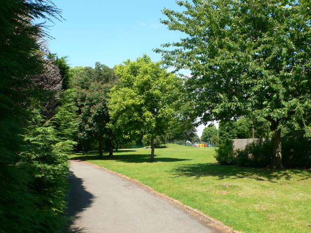
Nature enthusiasts will appreciate the park's abundant green spaces and recreational facilities. Westminster Park has a large central park area with well-manicured lawns, playgrounds, and sports fields. This provides ample opportunities for outdoor activities such as picnics, sports, and leisurely walks.

Transportation links in Westminster Park are excellent, with frequent bus services connecting the area to Chester city center and surrounding towns. The nearby A55 road offers easy access to the wider road network, making it convenient for commuters.

Overall, Westminster Park is a charming and sought-after residential area, offering a blend of natural beauty, convenient amenities, and a strong sense of community spirit.

If you have any feedback on the listing, please let us know in the comments section below.

Westminster Park Images

Images are sourced within 2km of 53.176727/-2.9014784 or Grid Reference SJ3964. Thanks to Geograph Open Source API. All images are credited.

Chester: The River Dee embankment
Chester: Off the Wall PH and restaurant seen from Souters Lane
Chester: Souters Lane
Chester, River Dee embankment: Boats for hire
Chester, River Dee embankment: Booth selling ice creams
Chester, River Dee embankment: Sightseeing bus
Chester, River Dee embankment: 'Lady Diana' sightseeing boat
Chester: The Roman amphitheatre
Chester: Newgate, a bridge carrying the walkway of the city walls over Pepper Street
Chester: St. John's College remains
Chester: Pepper Street A school party that had just finished playing at 'gladiators' in the amphitheatre can be seen, their teacher in full Roman centurion uniform.
Chester: Pepper Street
A school party that had just finished playing at 'gladiators' in the amphitheatre can be seen, their teacher in full Roman centurion uniform.
Chester: The Roman amphitheatre
Chester: The Roman amphitheatre and Newgate beyond
Chester: The Roman amphitheatre
Chester, River Dee embankment: Sightseeing bus
Chester, River Dee embankment: 'Lady Diana' sightseeing boat
Chester, River Dee embankment: 'Lady Diana' sightseeing boat and other boats for hire
Show me another place!

Westminster Park is located at Grid Ref: SJ3964 (Lat: 53.176727, Lng: -2.9014784)

Unitary Authority: Cheshire West and Chester

Police Authority: Cheshire

What 3 Words

///stream.refuse.danger. Near Chester, Cheshire

Nearby Locations

Westminster Park

Related Wikis

Westminster Park

Westminster Park is both a suburb to the west of Chester in England, and a large park the area takes its name after. Chester residents do not consider...
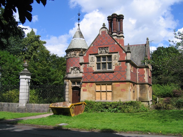
Overleigh Lodge

Overleigh Lodge is in Duke's Drive, Chester, Cheshire, England. The lodge, together with its associated gates, gate piers and screens, are recorded in...

Curzon Park Abbey

Curzon Park Abbey is one of three monasteries of nuns in the English Benedictine Congregation. == History == It began as an Anglican Benedictine convent...

Chester Catholic High School

Chester Catholic High School or CHSC but officially called The Catholic High School, Chester is a co-educational Roman Catholic secondary school and sixth...

Nearby Amenities

Located within 500m of 53.176727,-2.9014784
Turning Circle
Turning Circle: knuckle
Lat/Long: 53.1732455/-2.9031067
Crossing: no
Lat/Long: 53.1800948/-2.8968449
Bench
Backrest: yes
Lat/Long: 53.1783073/-2.895627
Crossing
Crossing: traffic_signals
Crossing Ref: toucan
Kerb: lowered
Tactile Paving: yes
Lat/Long: 53.1771509/-2.8966544
Bench
Backrest: yes
Lat/Long: 53.1768834/-2.8947764
Bus Stop
Hough Green, Overleigh Roundabout
Bench: no
Bus: yes
Naptan AtcoCode: 0610CH1066
Naptan Bearing: SW
Naptan CommonName: Overleigh Roundabout
Naptan Crossing: Curzon Park North
Naptan Indicator: SW-bound
Naptan Landmark: Overleigh Roundabout
Naptan LocalityName: Hough Green
Naptan NaptanCode: chwgagj
Naptan PlusbusZoneRef: CHST
Naptan ShortCommonName: Overleigh R'ndabout
Naptan Street: Hough Green
Naptan Verified: no
Public Transport: platform
Shelter: no
Source: naptan_import
Lat/Long: 53.1797828/-2.8986734
Bus Stop
Hough Green, Overleigh Roundabout
Bench: no
Bus: yes
Naptan AtcoCode: 0610CH1067
Naptan Bearing: E
Naptan CommonName: Overleigh Roundabout
Naptan Crossing: Curzon Park North
Naptan Indicator: E-bound
Naptan Landmark: Overleigh Roundabout
Naptan LocalityName: Hough Green
Naptan NaptanCode: chwgagm
Naptan PlusbusZoneRef: CHST
Naptan ShortCommonName: Overleigh R'ndabout
Naptan Street: Hough Green
Naptan Verified: no
Public Transport: platform
Shelter: no
Source: naptan_import
Lat/Long: 53.1799741/-2.8983651
Bus Stop
Hough Green, Hough Green / Howe Road
Bus: yes
Naptan AtcoCode: 0610CH1068
Naptan Bearing: E
Naptan CommonName: Howe Road
Naptan Crossing: Howe Road
Naptan Indicator: cnr
Naptan Landmark: Howe Road
Naptan LocalityName: Hough Green
Naptan NaptanCode: chwgagp
Naptan PlusbusZoneRef: CHST
Naptan ShortCommonName: Howe Road
Naptan Street: Hough Green
Naptan Verified: no
Public Transport: platform
Source: naptan_import
Lat/Long: 53.1795997/-2.9015146
Bus Stop
Hough Green, Hough Green / Cavendish Road
Bus: yes
Naptan AtcoCode: 0610CH1069
Naptan Bearing: W
Naptan CommonName: Cavendish Road
Naptan Crossing: Cavendish Road
Naptan Indicator: cnr
Naptan Landmark: Cavendish Road
Naptan LocalityName: Hough Green
Naptan NaptanCode: chwgagt
Naptan PlusbusZoneRef: CHST
Naptan ShortCommonName: Cavendish Road
Naptan Street: Hough Green
Naptan Verified: no
Public Transport: platform
Source: naptan_import
Lat/Long: 53.1792743/-2.9029442
Bus Stop
Hough Green, Hough Green / Selkirk Drive
Bus: yes
Naptan AtcoCode: 0610CH1070
Naptan Bearing: E
Naptan CommonName: Selkirk Drive
Naptan Crossing: Selkirk Drive
Naptan Indicator: after
Naptan Landmark: Dolphin Court
Naptan LocalityName: Hough Green
Naptan NaptanCode: chwgagw
Naptan PlusbusZoneRef: CHST
Naptan ShortCommonName: Selkirk Drive
Naptan Street: Hough Green
Naptan Verified: no
Public Transport: platform
Source: naptan_import
Lat/Long: 53.1789788/-2.9075168
Bus Stop
Westminster Park, Lache Lane / Cavendish Road
Bus: yes
Naptan AtcoCode: 0610CH1089
Naptan Bearing: NE
Naptan CommonName: Cavendish Road
Naptan Crossing: Cavendish Road
Naptan Indicator: nr
Naptan Landmark: House number 14
Naptan LocalityName: Westminster Park
Naptan NaptanCode: chwgamg
Naptan PlusbusZoneRef: CHST
Naptan ShortCommonName: Cavendish Road
Naptan Street: Lache Lane
Naptan Verified: no
Public Transport: platform
Source: naptan_import
Lat/Long: 53.1770136/-2.9011312
Bus Stop
Westminster Park, Lache Lane / Overleigh Roundabout
Bus: yes
Naptan AtcoCode: 0610CH1091
Naptan Bearing: NE
Naptan CommonName: Overleigh Roundabout
Naptan Indicator: NE-bound
Naptan Landmark: Overleigh Roundabout
Naptan LocalityName: Westminster Park
Naptan NaptanCode: chwgamj
Naptan PlusbusZoneRef: CHST
Naptan ShortCommonName: Overliegh R'ndabout
Naptan Street: Lache Lane
Naptan Verified: no
Public Transport: platform
Source: naptan_import
Lat/Long: 53.1789074/-2.8979538
Bus Stop
Chester, Wrexham Road / Grosvenor Nuffield Hospital
Bus: yes
Naptan AtcoCode: 0610CH2526
Naptan Bearing: S
Naptan CommonName: Grosvenor Nuffield Hospital
Naptan Indicator: o/s
Naptan Landmark: Grosvenor Nuffield Hospital
Naptan LocalityName: Chester
Naptan NaptanCode: chwmtmt
Naptan PlusbusZoneRef: CHST
Naptan ShortCommonName: Grosvenor Hospital
Naptan Street: Wrexham Road
Naptan Verified: no
Public Transport: platform
Source: naptan_import
Lat/Long: 53.1757131/-2.8965103
Bus Stop
Chester, Wrexham Road / Grosvenor Nuffield Hospital
Bus: yes
Naptan AtcoCode: 0610CH2527
Naptan Bearing: N
Naptan CommonName: Grosvenor Nuffield Hospital
Naptan Indicator: opp
Naptan Landmark: Grosvenor Nuffield Hospital
Naptan LocalityName: Chester
Naptan NaptanCode: chwmtmw
Naptan PlusbusZoneRef: CHST
Naptan ShortCommonName: Grosvenor Hospital
Naptan Street: Wrexham Road
Naptan Verified: no
Public Transport: platform
Source: naptan_import
Lat/Long: 53.1762725/-2.8968322
Bus Stop
Westminster Park, Lache Lane / Overleigh Roundabout
Bus: yes
Naptan AtcoCode: 0610CH2529
Naptan Bearing: SW
Naptan CommonName: Overleigh Roundabout
Naptan Indicator: SW-bound
Naptan Landmark: Overleigh Roundabout
Naptan LocalityName: Westminster Park
Naptan NaptanCode: chwmtpa
Naptan PlusbusZoneRef: CHST
Naptan ShortCommonName: Overliegh R'ndabout
Naptan Street: Lache Lane
Naptan Verified: no
Public Transport: platform
Source: naptan_import
Lat/Long: 53.1785386/-2.897991
Bus Stop
Westminster Park, Lache Lane / Cavendish Road
Bus: yes
Naptan AtcoCode: 0610CH2531
Naptan Bearing: SW
Naptan CommonName: Cavendish Road
Naptan Crossing: Cavendish Road
Naptan Indicator: opp
Naptan Landmark: Cavendish Road
Naptan LocalityName: Westminster Park
Naptan NaptanCode: chwmtpd
Naptan PlusbusZoneRef: CHST
Naptan ShortCommonName: Cavendish Road
Naptan Street: Lache Lane
Naptan Verified: no
Public Transport: platform
Source: naptan_import
Lat/Long: 53.176706/-2.9013941
Traffic Signals
Crossing: traffic_signals
Lat/Long: 53.1793631/-2.8965864
Crossing
Crossing: traffic_signals
Crossing Ref: pelican
Lat/Long: 53.1793716/-2.8964965
Traffic Signals
Lat/Long: 53.1798876/-2.8965705
Traffic Signals
Button Operated: no
Crossing: traffic_signals
Lat/Long: 53.1799919/-2.8973712
Traffic Signals
Lat/Long: 53.1794721/-2.8973241
Traffic Signals
Lat/Long: 53.1799422/-2.8964298
Traffic Signals
Lat/Long: 53.1794498/-2.8966719
Traffic Signals
Lat/Long: 53.1794934/-2.8971994
Traffic Signals
Lat/Long: 53.1799075/-2.8972028
Crossing
Crossing: traffic_signals
Crossing Ref: toucan
Kerb: lowered
Tactile Paving: yes
Lat/Long: 53.1793534/-2.9026926
Hough Green
Place: suburb
Lat/Long: 53.1802188/-2.9053309
Bicycle Parking
Capacity: 20
Lat/Long: 53.1765864/-2.9062516
Crossing
Button Operated: no
Crossing: traffic_signals
Crossing Island: no
Kerb: lowered
Tactile Paving: yes
Lat/Long: 53.1800958/-2.8973628
Direction: WSW
Generator Method: photovoltaic
Generator Output Electricity: yes
Generator Source: solar
Generator Type: solar_photovoltaic_panel
Location: roof
Power: generator
Lat/Long: 53.1745281/-2.8974561
Direction: SSE
Generator Method: photovoltaic
Generator Output Electricity: yes
Generator Source: solar
Generator Type: solar_photovoltaic_panel
Location: roof
Power: generator
Lat/Long: 53.174931/-2.8972754
Direction: SW
Generator Method: photovoltaic
Generator Output Electricity: yes
Generator Source: solar
Generator Type: solar_photovoltaic_panel
Location: roof
Power: generator
Lat/Long: 53.1766772/-2.9001208
Direction: WSW
Generator Method: photovoltaic
Generator Output Electricity: yes
Generator Source: solar
Generator Type: solar_photovoltaic_panel
Location: roof
Power: generator
Lat/Long: 53.1754117/-2.9001775
Direction: SSE
Generator Method: photovoltaic
Generator Output Electricity: yes
Generator Source: solar
Generator Type: solar_photovoltaic_panel
Location: roof
Power: generator
Lat/Long: 53.1739825/-2.9025969
Direction: WSW
Generator Method: photovoltaic
Generator Output Electricity: yes
Generator Source: solar
Generator Type: solar_photovoltaic_panel
Location: roof
Power: generator
Lat/Long: 53.1736872/-2.9018739
Direction: SSE
Generator Method: photovoltaic
Generator Output Electricity: yes
Generator Source: solar
Generator Type: solar_photovoltaic_panel
Location: roof
Power: generator
Lat/Long: 53.1723049/-2.900478
Direction: SSE
Generator Method: photovoltaic
Generator Output Electricity: yes
Generator Source: solar
Generator Type: solar_photovoltaic_panel
Location: roof
Power: generator
Lat/Long: 53.1722823/-2.9005872
Traffic Signals
Traffic Signals: signal
Lat/Long: 53.1799088/-2.8973109
Direction: SSE
Generator Method: photovoltaic
Generator Output Electricity: yes
Generator Source: solar
Generator Type: solar_photovoltaic_panel
Location: roof
Power: generator
Lat/Long: 53.1776349/-2.8989288
Direction: SSE
Generator Method: photovoltaic
Generator Output Electricity: yes
Generator Source: solar
Generator Type: solar_photovoltaic_panel
Location: roof
Power: generator
Lat/Long: 53.1776124/-2.898988
Direction: SSE
Generator Method: photovoltaic
Generator Output Electricity: yes
Generator Source: solar
Generator Type: solar_photovoltaic_panel
Location: roof
Power: generator
Lat/Long: 53.1775345/-2.8990684
Direction: SSE
Generator Method: photovoltaic
Generator Output Electricity: yes
Generator Source: solar
Generator Type: solar_photovoltaic_panel
Location: roof
Power: generator
Lat/Long: 53.1775023/-2.8991438
Direction: SSE
Generator Method: photovoltaic
Generator Output Electricity: yes
Generator Source: solar
Generator Type: solar_photovoltaic_panel
Location: roof
Power: generator
Lat/Long: 53.1768647/-2.9004986
Direction: SSW
Generator Method: photovoltaic
Generator Output Electricity: yes
Generator Source: solar
Generator Type: solar_photovoltaic_panel
Location: roof
Power: generator
Lat/Long: 53.1764741/-2.8999482
Direction: SSE
Generator Method: photovoltaic
Generator Output Electricity: yes
Generator Source: solar
Generator Type: solar_photovoltaic_panel
Location: roof
Power: generator
Lat/Long: 53.180644/-2.8996263
Direction: WSW
Generator Method: photovoltaic
Generator Output Electricity: yes
Generator Source: solar
Generator Type: solar_photovoltaic_panel
Location: roof
Power: generator
Lat/Long: 53.1736302/-2.901292
Bench
Lat/Long: 53.179032/-2.8953677
Post Box
Brand: Royal Mail
Brand Wikidata: Q638098
Brand Wikipedia: en:Royal Mail
Collection Times: Mo-Fr 09:00; Sa 07:00; Su off
Drive Through: no
Operator: Royal Mail
Operator Wikidata: Q638098
Post Box Type: pillar
Ref: CH4 134D
Royal Cypher: GR
Royal Cypher Wikidata: Q33102273
Lat/Long: 53.1768504/-2.9014194
Post Box
Collection Times: Mo-Fr 09:00; Sa 07:00
Drive Through: no
Operator: Royal Mail
Operator Wikidata: Q638098
Post Box Type: wall
Ref: CH4 62D
Royal Cypher: EIIR
Royal Cypher Wikidata: Q33102113
Lat/Long: 53.1792136/-2.905049
Bus Stop
Westminster Park, Vincent Drive (Hail & Ride)
Bus: yes
Naptan AtcoCode: 0610CH19002
Naptan Bearing: SE
Naptan BusStopType: HAR
Naptan CommonName: Vincent Drive
Naptan Indicator: SE-bound
Naptan Landmark: Hail & Ride
Naptan LocalityName: Westminster Park
Naptan NaptanCode: chwtapd
Naptan PlusbusZoneRef: CHST
Naptan ShortCommonName: Vincent Drive (H&R)
Naptan Street: Vincent Drive
Public Transport: platform
Source: naptan_import
Lat/Long: 53.1753713/-2.9026169
Bus Stop
Westminster Park, Vincent Drive (Hail & Ride)
Bus: yes
Naptan AtcoCode: 0610CH19003
Naptan Bearing: NW
Naptan BusStopType: HAR
Naptan CommonName: Vincent Drive
Naptan Indicator: NW-bound
Naptan Landmark: Hail & Ride
Naptan LocalityName: Westminster Park
Naptan NaptanCode: chwtatg
Naptan PlusbusZoneRef: CHST
Naptan ShortCommonName: Vincent Drive (H&R)
Naptan Street: Vincent Drive
Public Transport: platform
Source: naptan_import
Lat/Long: 53.1752535/-2.9027491
Bus Stop
Westminster Park, Dennis Drive (Hail & Ride)
Bus: yes
Naptan AtcoCode: 0610CH19005
Naptan Bearing: NW
Naptan BusStopType: HAR
Naptan CommonName: Dennis Drive
Naptan Indicator: NW-bound
Naptan Landmark: Dennis Drive
Naptan LocalityName: Westminster Park
Naptan NaptanCode: chwtatj
Naptan PlusbusZoneRef: CHST
Naptan ShortCommonName: Dennis Drive (H&R)
Naptan Street: Dennis Drive
Public Transport: platform
Source: naptan_import
Lat/Long: 53.1746131/-2.901838
Bus Stop
Westminster Park, Dennis Drive (Hail & Ride)
Bus: yes
Naptan AtcoCode: 0610CH19004
Naptan Bearing: SE
Naptan BusStopType: HAR
Naptan CommonName: Dennis Drive
Naptan Indicator: SE-bound
Naptan Landmark: Dennis Drive
Naptan LocalityName: Westminster Park
Naptan NaptanCode: chwtatd
Naptan PlusbusZoneRef: CHST
Naptan ShortCommonName: Dennis Drive (H&R)
Naptan Street: Dennis Drive
Public Transport: platform
Source: naptan_import
Lat/Long: 53.1747045/-2.9016454
Bus Stop
Westminster Park, Rushfield Road (Hail & Ride)
Bus: yes
Naptan AtcoCode: 0610CH19007
Naptan Bearing: SW
Naptan BusStopType: HAR
Naptan CommonName: Rushfield Road
Naptan Indicator: SW-bound
Naptan Landmark: Hail & Ride
Naptan LocalityName: Westminster Park
Naptan NaptanCode: chwtamw
Naptan PlusbusZoneRef: CHST
Naptan ShortCommonName: Rushfield Rd (H&R)
Naptan Street: Rushfield Road
Public Transport: platform
Source: naptan_import
Lat/Long: 53.1737084/-2.9036181
Bus Stop
Westminster Park, Rushfield Road (Hail & Ride)
Bus: yes
Naptan AtcoCode: 0610CH19006
Naptan Bearing: NE
Naptan BusStopType: HAR
Naptan CommonName: Rushfield Road
Naptan Indicator: NE-bound
Naptan Landmark: Hail & Ride
Naptan LocalityName: Westminster Park
Naptan NaptanCode: chwtatm
Naptan PlusbusZoneRef: CHST
Naptan ShortCommonName: Rushfield Rd (H&R)
Naptan Street: Rushfield Road
Public Transport: platform
Source: naptan_import
Lat/Long: 53.1738608/-2.9036661
The data included in this document is from www.openstreetmap.org. The data is made available under ODbL.

Have you been to Westminster Park?

Leave your review of Westminster Park below (or comments, questions and feedback).