Town End

Settlement in Yorkshire

England

Town End

Albert Drive, Ossett
Albert Drive, Ossett Credit: habiloid

Town End is a small rural village located in the county of Yorkshire, in the northern region of England. Situated amidst picturesque countryside, this idyllic village offers a tranquil and charming setting for its residents and visitors alike. With a population of around 500 people, Town End exudes a strong sense of community and a slower pace of life.

The village is characterized by its traditional stone-built houses, which contribute to its quintessential English village charm. The surrounding landscape is predominantly rolling hills, dotted with lush green fields and meandering streams. This creates a scenic backdrop for outdoor activities such as walking, cycling, and picnicking.

Town End boasts a few local amenities to cater to the needs of its residents. There is a village shop that provides essential groceries and daily necessities, ensuring that the community has easy access to basic provisions. Additionally, a cozy country pub can be found at the heart of the village, serving locally sourced food and beverages, and acting as a social hub for residents to gather and socialize.

The village also benefits from its proximity to larger towns and cities. The nearest town, located just a few miles away, offers a wider range of amenities including supermarkets, schools, and healthcare facilities. The surrounding area is rich in historical landmarks and tourist attractions, with stately homes, museums, and ancient ruins within easy reach.

Overall, Town End embodies the charm and tranquility of a typical Yorkshire village, providing a peaceful haven for its residents and an inviting destination for nature lovers and those seeking a break from the hustle and bustle of city life.

If you have any feedback on the listing, please let us know in the comments section below.
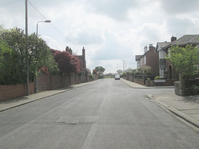
Town End Images

Images are sourced within 2km of 53.685076/-1.5763274 or Grid Reference SE2821. Thanks to Geograph Open Source API. All images are credited.

Albert Drive, Ossett
The side of Ossett Fire Station, Mothers Way, Ossett
The Wilfred, Ossett
The Wilfred, Ossett
Memorial Garden At Rear Of St Ignatius Church, Ossett
Southdale Road - Queen Street
The Green - viewed from Southdale Road
Dimple Wells Road - The Green
Footpath alongside Cricket Ground - end of Stoneleigh
Ossett Cricket Club Ground - viewed from Stoneleigh
Queens Drive - looking towards Station Road
Lime Street - looking towards Station Road
Belgrave Street - looking towards Lime Street
Belgrave Avenue - Belgrave Street
Barmby Crescent - Fairfield Drive
Footpath - South Parade
South Parade - looking towards Manor Road
Greenfield Road - looking towards South Parade
Greenfield Avenue - looking towards Greenfield Road
Show me another place!

Town End is located at Grid Ref: SE2821 (Lat: 53.685076, Lng: -1.5763274)

Division: West Riding

Unitary Authority: Wakefield

Police Authority: West Yorkshire

What 3 Words

///reefs.massaging.hobbyists. Near Ossett, West Yorkshire

Related Wikis

Ossett Town A.F.C.

Ossett Town Association Football Club was an English football club based in Ossett in West Yorkshire. == History == Ossett Town AFC were formed in 1936...

Ossett United F.C.

Ossett United Football Club is a football club based in Ossett, West Yorkshire, England. They are currently members of the Northern Premier League Division...

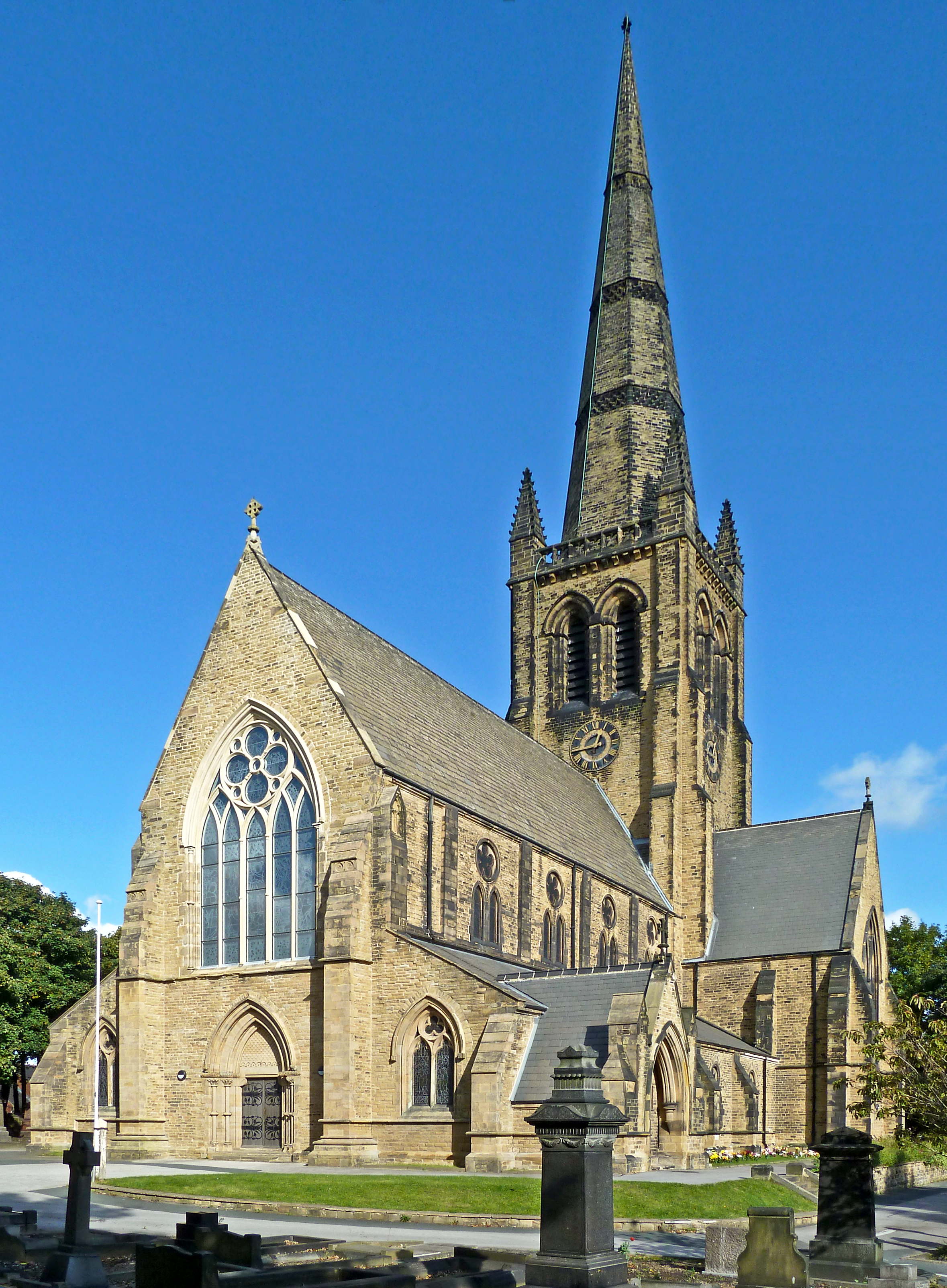
Trinity Church, Ossett

The Church of the Holy and Undivided Trinity, more commonly known as Trinity Church, is the main Church of England parish church for the market town of...
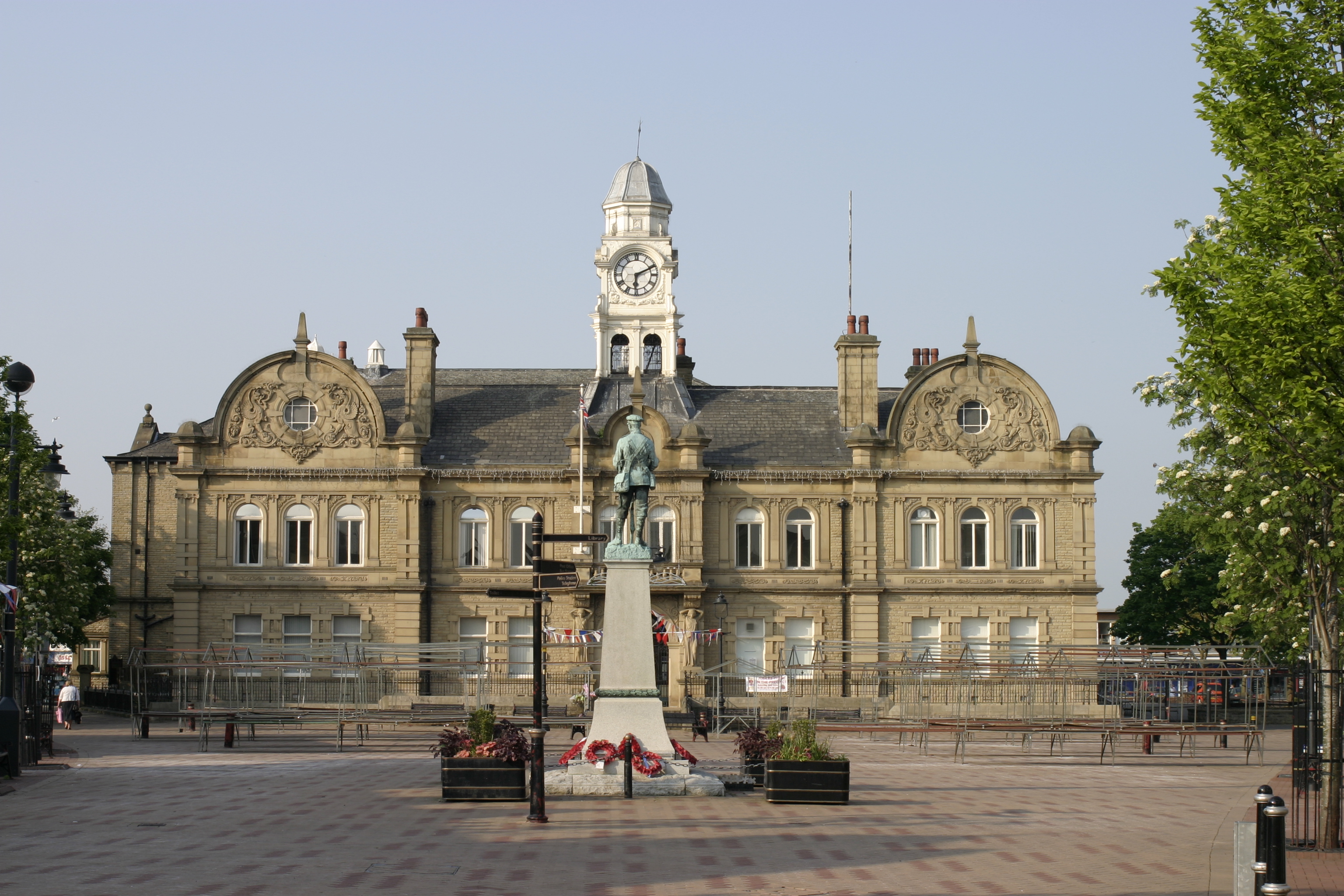
Ossett Town Hall

Ossett Town Hall is a municipal building in the Market Place, Ossett, West Yorkshire, England. The town hall, which was the headquarters of Ossett Borough...

Nearby Amenities

Located within 500m of 53.685076,-1.5763274
Traffic Signals
Button Operated: yes
Crossing: traffic_signals
Crossing Ref: pelican
Kerb: flush
Tactile Paving: yes
Traffic Signals Direction: both
Traffic Signals Sound: yes
Traffic Signals Vibration: yes
Lat/Long: 53.6813825/-1.5791556
Bus Stop
Wakefield Road Milner Way
Bus: yes
Local Ref: 45020432
Naptan AtcoCode: 450020432
Naptan Bearing: W
Naptan CommonName: Wakefield Road Milner Way
Naptan Crossing: Milner Way
Naptan Indicator: Stop 45020432
Naptan PlusbusZoneRef: LEEDS
Naptan ShortCommonName: Milner Way
Naptan Street: Wakefield Road
Naptan Verified: yes
Public Transport: platform
Ref: 45020432
Source: naptan_import
Lat/Long: 53.6856604/-1.574213
Bus Stop
Dale Street Ferndale
Bench: no
Bin: no
Bus: yes
Lit: yes
Local Ref: 45020402
Naptan AtcoCode: 450020402
Naptan Bearing: NE
Naptan CommonName: Dale Street Ferndale
Naptan Crossing: Ferndale
Naptan Indicator: Stop 45020402
Naptan Landmark: Fire Station
Naptan PlusbusZoneRef: LEEDS
Naptan ShortCommonName: Ferndale
Naptan Street: Dale Street
Naptan Verified: yes
Public Transport: platform
Ref: 45020402
Shelter: no
Source: naptan_import
Tactile Paving: no
Timetable: yes
Lat/Long: 53.68307/-1.578196
Bus Stop
Dale Street Dale Close
Bench: no
Bin: no
Bus: yes
Lit: yes
Local Ref: 45020403
Naptan AtcoCode: 450020403
Naptan Bearing: SW
Naptan CommonName: Dale Street Dale Close
Naptan Crossing: Dale Close
Naptan Indicator: Stop 45020403
Naptan PlusbusZoneRef: LEEDS
Naptan ShortCommonName: Dale Close
Naptan Street: Dale Street
Naptan Verified: yes
Public Transport: platform
Ref: 45020403
Shelter: no
Source: naptan_import
Tactile Paving: no
Lat/Long: 53.6834749/-1.5776541
Pub
The Commercial
Note: Closed Down
Lat/Long: 53.6858215/-1.5761457
Post Box
Operator: Royal Mail
Post Box Type: pillar
Ref: WF5 23
Lat/Long: 53.6857279/-1.5755473
Power: substation
Lat/Long: 53.6834736/-1.5740194
Bus Stop
Dewsbury Road Woodbine Street
Bus: yes
Local Ref: 45020434
Naptan AtcoCode: 450020434
Naptan Bearing: SE
Naptan CommonName: Dewsbury Road Woodbine Street
Naptan Crossing: Woodbine Street
Naptan Indicator: Stop 45020434
Naptan PlusbusZoneRef: LEEDS
Naptan ShortCommonName: Woodbine Street
Naptan Street: Dewsbury Road
Naptan Verified: yes
Public Transport: platform
Ref: 45020434
Source: naptan_import
Lat/Long: 53.6864061/-1.5771659
Bus Stop
Dewsbury Road Woodbine Street
Bus: yes
Local Ref: 45020433
Naptan AtcoCode: 450020433
Naptan Bearing: NW
Naptan CommonName: Dewsbury Road Woodbine Street
Naptan Crossing: Woodbine Street
Naptan Indicator: Stop 45020433
Naptan Landmark: The Commercial PH
Naptan PlusbusZoneRef: LEEDS
Naptan ShortCommonName: Woodbine Street
Naptan Street: Dewsbury Road
Naptan Verified: yes
Public Transport: platform
Ref: 45020433
Shelter: yes
Source: naptan_import
Timetable: yes
Lat/Long: 53.6860983/-1.5767646
Bus Stop
Wakefield Road Milner Way
Bus: yes
Local Ref: 45020431
Naptan AtcoCode: 450020431
Naptan Bearing: E
Naptan CommonName: Wakefield Road Milner Way
Naptan Crossing: Milner Way
Naptan Indicator: Stop 45020431
Naptan Landmark: Factory
Naptan PlusbusZoneRef: LEEDS
Naptan ShortCommonName: Milner Way
Naptan Street: Wakefield Road
Naptan Verified: yes
Public Transport: platform
Ref: 45020431
Source: naptan_import
Lat/Long: 53.6859282/-1.5734248
Crossing
Crossing: unmarked
Crossing Island: yes
Lat/Long: 53.6857964/-1.5755282
Crossing
Lat/Long: 53.6857797/-1.5705598
Bus Stop
Wakefield Road Eldon Street
Local Ref: 45020430
Naptan AtcoCode: 450020430
Naptan Bearing: W
Naptan CommonName: Wakefield Road Eldon Street
Naptan Crossing: Eldon Street
Naptan Indicator: Stop 45020430
Naptan Landmark: Garage
Naptan PlusbusZoneRef: LEEDS
Naptan ShortCommonName: Eldon Street
Naptan Street: Wakefield Road
Naptan Verified: yes
Ref: 45020430
Source: naptan_import
Lat/Long: 53.6856199/-1.569518
Bus Stop
Church Street Ashbrook Close
Bus: yes
Local Ref: 45020418
Naptan AtcoCode: 450020418
Naptan Bearing: NW
Naptan CommonName: Church Street Ashbrook Close
Naptan Crossing: Ashbrook Close
Naptan Indicator: Stop 45020418
Naptan Landmark: Church
Naptan PlusbusZoneRef: LEEDS
Naptan ShortCommonName: Ashbrook Close
Naptan Street: Church Street
Naptan Verified: yes
Public Transport: platform
Ref: 45020418
Source: naptan_import
Lat/Long: 53.6857468/-1.5834764
Bus Stop
Church Street Ashbrook Close
Bus: yes
Local Ref: 45020419
Naptan AtcoCode: 450020419
Naptan Bearing: SE
Naptan CommonName: Church Street Ashbrook Close
Naptan Crossing: Ashbrook Close
Naptan Indicator: Stop 45020419
Naptan Landmark: Church
Naptan PlusbusZoneRef: LEEDS
Naptan ShortCommonName: Ashbrook Close
Naptan Street: Church Street
Naptan Verified: yes
Public Transport: platform
Ref: 45020419
Shelter: no
Source: naptan_import
Timetable: yes
Lat/Long: 53.6855377/-1.5831804
Bus Stop
Church Street Gunson Crescent
Bench: no
Bin: yes
Bus: yes
Lit: yes
Local Ref: 45020422
Naptan AtcoCode: 450020422
Naptan Bearing: NW
Naptan CommonName: Church Street Gunson Crescent
Naptan Crossing: Gunson Street
Naptan Indicator: Stop 45020422
Naptan PlusbusZoneRef: LEEDS
Naptan ShortCommonName: Gunson Crescent
Naptan Street: Church Street
Naptan Verified: no
Public Transport: platform
Ref: 45020422
Shelter: no
Source: naptan_import
Tactile Paving: no
Timetable: yes
Lat/Long: 53.6816735/-1.5799089
Bus Stop
Church Street Field Lane
Local Ref: 45020421
Naptan AtcoCode: 450020421
Naptan Bearing: S
Naptan CommonName: Church Street Field Lane
Naptan Crossing: Field Lane
Naptan Indicator: Stop 45020421
Naptan Landmark: School
Naptan PlusbusZoneRef: LEEDS
Naptan ShortCommonName: Field Lane
Naptan Street: Church Street
Naptan Verified: yes
Ref: 45020421
Source: naptan_import
Lat/Long: 53.6826579/-1.580725
Ossett Fire Station
Disused Amenity: fire_station
Note: station 89
Operator: WYFRS
Lat/Long: 53.6829347/-1.5786242
Power: substation
Lat/Long: 53.6826673/-1.5787747
Pub
The Red Lion
Addr City: Ossett
Addr Housenumber: 73
Addr Postcode: WF5 9NQ
Addr Street: Dewsbury Road
Fhrs Id: 679929
Lat/Long: 53.6876619/-1.5811669
Power: substation
Lat/Long: 53.6883363/-1.5789284
Bus Stop
Dale Street Cromwell Place
Bench: no
Bin: no
Bus: yes
Lit: yes
Local Ref: 45020404
Naptan AtcoCode: 450020404
Naptan Bearing: SW
Naptan CommonName: Dale Street Cromwell Place
Naptan Crossing: Cromwell Place
Naptan Indicator: Stop 45020404
Naptan Landmark: Church Hall
Naptan PlusbusZoneRef: LEEDS
Naptan ShortCommonName: Cromwell Place
Naptan Street: Dale Street
Naptan Verified: yes
Public Transport: platform
Ref: 45020404
Shelter: no
Source: naptan_import
Tactile Paving: no
Lat/Long: 53.6849978/-1.5763688
Bus Stop
Church Street Field Lane
Local Ref: 45020420
Naptan AtcoCode: 450020420
Naptan Bearing: N
Naptan CommonName: Church Street Field Lane
Naptan Crossing: Field Lane
Naptan Indicator: Stop 45020420
Naptan Landmark: School
Naptan PlusbusZoneRef: LEEDS
Naptan ShortCommonName: Field Lane
Naptan Street: Church Street
Naptan Verified: no
Source: naptan_import
Lat/Long: 53.6826189/-1.5808896
Bus Stop
Dewsbury Road Far Richard Close
Local Ref: 45020435
Naptan AtcoCode: 450020435
Naptan Bearing: SE
Naptan CommonName: Dewsbury Road Far Richard Close
Naptan Crossing: Far Richard Close
Naptan Indicator: Stop 45020435
Naptan PlusbusZoneRef: LEEDS
Naptan ShortCommonName: Far Richard Close
Naptan Street: Dewsbury Road
Naptan Verified: yes
Ref: 45020435
Source: naptan_import
Lat/Long: 53.6874973/-1.5802052
Bus Stop
Dewsbury Road Far Richard Close
Local Ref: 45020436
Naptan AtcoCode: 450020436
Naptan Bearing: NW
Naptan CommonName: Dewsbury Road Far Richard Close
Naptan Crossing: Far Richard Close
Naptan Indicator: Stop 45020436
Naptan Landmark: Garage
Naptan PlusbusZoneRef: LEEDS
Naptan ShortCommonName: Far Richard Close
Naptan Street: Dewsbury Road
Naptan Verified: yes
Ref: 45020436
Source: naptan_import
Lat/Long: 53.6875166/-1.5805987
Bus Stop
Stand A Ossett Bus Station
Bench: yes
Bin: no
Bus: yes
Lit: yes
Live Display: yes
Local Ref: 45026125
Naptan AtcoCode: 450026125
Naptan CommonName: Stand A Ossett Bus Station
Naptan Crossing: Low Fold
Naptan Indicator: Stop 45026125
Naptan Landmark: Ossett Bus Station
Naptan PlusbusZoneRef: LEEDS
Naptan ShortCommonName: Ossett Bus Stn A
Naptan Street: A - Ossett Bus Station - Prospect Road
Naptan Verified: yes
Public Transport: platform
Shelter: yes
Source: naptan_import
Timetable: yes
Lat/Long: 53.6807861/-1.5784987
Bus Stop
Stand B Ossett Bus Station
Bench: yes
Bus: yes
Lit: yes
Live Display: yes
Local Ref: 45026126
Naptan AtcoCode: 450026126
Naptan CommonName: Stand B Ossett Bus Station
Naptan Crossing: Low Fold
Naptan Indicator: Stop 45026126
Naptan Landmark: Ossett Bus Station
Naptan PlusbusZoneRef: LEEDS
Naptan ShortCommonName: Ossett Bus Stn B
Naptan Street: B - Ossett Bus Station - Prospect Road
Naptan Verified: yes
Public Transport: platform
Shelter: yes
Source: naptan_import
Timetable: yes
Lat/Long: 53.6807571/-1.5784357
Milner Way
Naptan AtcoCode: 450028680
Naptan Bearing: NE
Naptan BusStopType: CUS
Naptan CommonName: Milner Way
Naptan Crossing: Mortimer Rise
Naptan Landmark: Unknown
Naptan PlusbusZoneRef: LEEDS
Naptan ShortCommonName: Milner Way
Naptan Street: Milner Way
Naptan Verified: no
Source: naptan_import
Lat/Long: 53.6836024/-1.5692666
Dale Street Cromwell Place
Local Ref: 45050950
Naptan AtcoCode: 450050950
Naptan Bearing: NE
Naptan BusStopType: CUS
Naptan CommonName: Dale Street Cromwell Place
Naptan Indicator: Stop 45050950
Naptan PlusbusZoneRef: LEEDS
Naptan ShortCommonName: Cromwell Place
Naptan Street: Dale Street
Naptan Verified: no
Source: naptan_import
Lat/Long: 53.6850251/-1.5764745
Post Box
Operator: Royal Mail
Post Box Type: pillar
Ref: WF5 83
Lat/Long: 53.6858892/-1.571087
Post Box
Operator: Royal Mail
Post Box Type: wall
Ref: WF5 65
Royal Cypher: GVIR
Royal Cypher Wikidata: Q33102169
Lat/Long: 53.6847043/-1.5828907
Power: pole
Lat/Long: 53.6881952/-1.5737069
Design: h-frame
Line Management: termination
Location Transition: yes
Material: wood
Power: tower
Lat/Long: 53.6871353/-1.5749102
Power: pole
Lat/Long: 53.6878322/-1.5729813
Power: pole
Lat/Long: 53.6876964/-1.5738461
Power: pole
Lat/Long: 53.6879903/-1.5719209
Power: pole
Lat/Long: 53.68781/-1.5740454
Design: h-frame
Line Management: termination
Location Transition: yes
Material: wood
Power: tower
Lat/Long: 53.6870596/-1.5752523
Power: pole
Lat/Long: 53.6888164/-1.5731881
Restaurant
Nikoz
Addr City: Ossett
Addr Housenumber: 43
Addr Postcode: WF5 9DB
Addr Street: Dale Street
Cuisine: greek
Fhrs Id: 731090
Lat/Long: 53.6813452/-1.5794387
Speed Camera
Lat/Long: 53.6866377/-1.5703129
Speed Camera
Lat/Long: 53.6887567/-1.5746557
Addr City: Ossett
Addr Postcode: WF5 9ND
Lat/Long: 53.6875287/-1.5764083
Spurr's Quality Butchers
Addr City: Ossett
Addr Housenumber: 36
Addr Postcode: WF5 9HE
Addr Street: Dale Street
Fhrs Id: 1090696
Shop: butcher
Lat/Long: 53.6815054/-1.578848
Fast Food
Cheung's
Addr City: Ossett
Addr Housenumber: 41
Addr Postcode: WF5 9DB
Addr Street: Dale Street
Cuisine: chinese
Fhrs Id: 340217
Takeaway: yes
Lat/Long: 53.6812521/-1.5794027
Fast Food
A & M Sandwich Bar
Addr City: Ossett
Addr Housenumber: 35
Addr Postcode: WF5 9DB
Addr Street: Dale Street
Cuisine: sandwich
Fhrs Id: 812038
Lat/Long: 53.6811163/-1.5794912
Hitch Newsagents
Addr City: Ossett
Addr Housenumber: 28
Addr Postcode: WF5 9BT
Addr Street: Dale Street
Fhrs Id: 313988
Shop: newsagent
Lat/Long: 53.6812029/-1.5790889
The Play Station
Addr City: Ossett
Addr Housename: Main Warehouse RC Marsden Properties Ltd
Addr Postcode: WF5 9ND
Addr Street: Dewsbury Road
Addr Unit: 7B-7C
Fhrs Id: 284659
Indoor: yes
Leisure: playground
Lat/Long: 53.6867865/-1.5777478
Fast Food
The Big Butty Shop
Addr City: Ossett
Addr Housenumber: 2
Addr Postcode: WF5 9EQ
Addr Street: Springstone Avenue
Cuisine: sandwich
Fhrs Id: 284264
Takeaway: yes
Lat/Long: 53.6848939/-1.5826817
Kindergarten
Alpha & Omega Club
Addr City: Ossett
Addr Housename: Trinity Centre
Addr Postcode: WF5 9DW
Addr Street: Church Street
Fhrs Id: 781040
Lat/Long: 53.6854808/-1.5827407
Pub
Ossett Town AFC Social Club
Addr City: Ossett
Addr Postcode: WF5 9HA
Addr Street: Prospect Road
Fhrs Id: 313910
Lat/Long: 53.6810686/-1.5769739
Fast Food
Wo Sang
Addr City: Ossett
Addr Housenumber: 47a
Addr Postcode: WF5 9HE
Addr Street: Dale Street
Cuisine: chinese
Fhrs Id: 1216229
Takeaway: yes
Lat/Long: 53.6816755/-1.5791948
Cafe
Crocodile Sisters
Addr City: Ossett
Addr Housename: RC Marsden Properties Ltd
Addr Postcode: WF5 9ND
Addr Street: Dewsbury Road
Addr Unit: 1
Craft: caterer
Fhrs Id: 585562
Lat/Long: 53.6869074/-1.5774724
Bethany In Ossett
Addr City: Ossett
Addr Housename: Trinity Centre
Addr Postcode: WF5 9DW
Addr Street: Church Street
Fhrs Id: 812047
Lat/Long: 53.6854006/-1.582793
Kylie's Custom Cakes Bakehouse & Deli
Addr City: Ossett
Addr Housename: RC Marsden Properties Ltd
Addr Postcode: WF5 9ND
Addr Street: Dewsbury Road
Addr Unit: 5a
Fhrs Id: 1098270
Shop: bakery
Lat/Long: 53.6871804/-1.5775225
Car Wash
Gulf
Automated: yes
Self Service: no
Lat/Long: 53.6808344/-1.5773094
The data included in this document is from www.openstreetmap.org. The data is made available under ODbL.

Have you been to Town End?

Leave your review of Town End below (or comments, questions and feedback).