Studlands Park

Settlement in Suffolk West Suffolk

England

Studlands Park

Retail park by Fordham Road, Newmarket
Retail park by Fordham Road, Newmarket Credit: David Howard

Studlands Park is a residential area located in Suffolk, England. It is situated in the town of Newmarket, which is known for its horse racing heritage. Studlands Park is a popular choice for families and individuals looking for a peaceful and well-connected place to live.

The area offers a range of housing options, including detached houses, semi-detached houses, and bungalows. These properties are often surrounded by green spaces, providing residents with a pleasant and scenic environment. Many homes in Studlands Park have well-maintained gardens, adding to the overall appeal of the area.

Studlands Park benefits from its close proximity to Newmarket town center, which is just a short distance away. Here, residents can find a variety of amenities, including shops, supermarkets, cafes, restaurants, and leisure facilities. The town is also known for its vibrant market, where locals can purchase fresh produce and other goods.

For those seeking outdoor activities, Studlands Park is surrounded by beautiful countryside, including nearby nature reserves and parks. The National Stud, a renowned racehorse breeding facility, is also a popular attraction in the area.

Transportation links in Studlands Park are excellent, with easy access to major roads and highways. The town is well-connected to neighboring towns and cities, making it convenient for commuters. Additionally, there are regular bus services that operate within the area, providing residents with further transportation options.

Overall, Studlands Park offers a tranquil and well-connected place to live, with a range of amenities and outdoor activities to enjoy.

If you have any feedback on the listing, please let us know in the comments section below.

Studlands Park Images

Images are sourced within 2km of 52.264312/0.39229147 or Grid Reference TL6365. Thanks to Geograph Open Source API. All images are credited.

Retail park by Fordham Road, Newmarket
Burger King on Fordham Road, Newmarket My other visit. <a title="https://www.geograph.org.uk/photo/6564373" href="https://www.geograph.org.uk/photo/6564373">Link</a>
Burger King on Fordham Road, Newmarket
My other visit. Link
Lorry parked on Fordham Road
Layby on Fordham Road
Fordham Road, Newmarket
Burger King on Oaks Road, Newmarket The front is on Fordham Road. My previous two visits are catalogued here. <a title="https://www.geograph.org.uk/photo/6974167" href="https://www.geograph.org.uk/photo/6974167">Link</a>
Burger King on Oaks Road, Newmarket
The front is on Fordham Road. My previous two visits are catalogued here. Link
Studlands Shopping Park, Newmarket
Easter funfair on George Lambton Playing Fields, Newmarket
Slow going on A14 A 40 limit applied with three lanes down to two for road works.
Slow going on A14
A 40 limit applied with three lanes down to two for road works.
Chickens in Car Park, Service Area on A11,  Norfolk
Chickens in Car Park, Service Area on A11, Norfolk
The A14 Newmarket Bypass
Power lines by Heath Road  Looking towards Exning.
Power lines by Heath Road
Looking towards Exning.
Exning: cottages on the corner Heath Road bends sharply here. The entrance to the cemetery is behind the camera.
Exning: cottages on the corner
Heath Road bends sharply here. The entrance to the cemetery is behind the camera.
Exning: Lacey's Lane Victorian houses on the southern edge of the village.
Exning: Lacey's Lane
Victorian houses on the southern edge of the village.
Exning: the corner of Lacey's Lane Looking from the end of Ducks Lane. Chapel Street is to the right.
Exning: the corner of Lacey's Lane
Looking from the end of Ducks Lane. Chapel Street is to the right.
Exning: the White Horse At the corner of Swan Lane. The Grade II listed building dates from the late 18th century.
Exning: the White Horse
At the corner of Swan Lane. The Grade II listed building dates from the late 18th century.
Show me another place!

Studlands Park is located at Grid Ref: TL6365 (Lat: 52.264312, Lng: 0.39229147)

Administrative County: Suffolk

District: West Suffolk

Police Authority: Suffolk

What 3 Words

///icicles.innocence.galleries. Near Exning, Suffolk

Nearby Locations

Studlands Park

Related Wikis

The Rosery, Exning, Suffolk

The Rosery is an early Victorian country house in the town of Exning, Suffolk, England. The building was converted to a hotel in the 1970s. == Early... ==

Godolphin Stables

Godolphin Stables, also known as Stanley House Stables, is a thoroughbred racehorse ownership, training and breeding operation in Newmarket, Suffolk, which...

Newmarket Academy

Newmarket Academy (formerly Newmarket College) is a coeducational secondary school with academy status located in Newmarket in the English county of Suffolk...
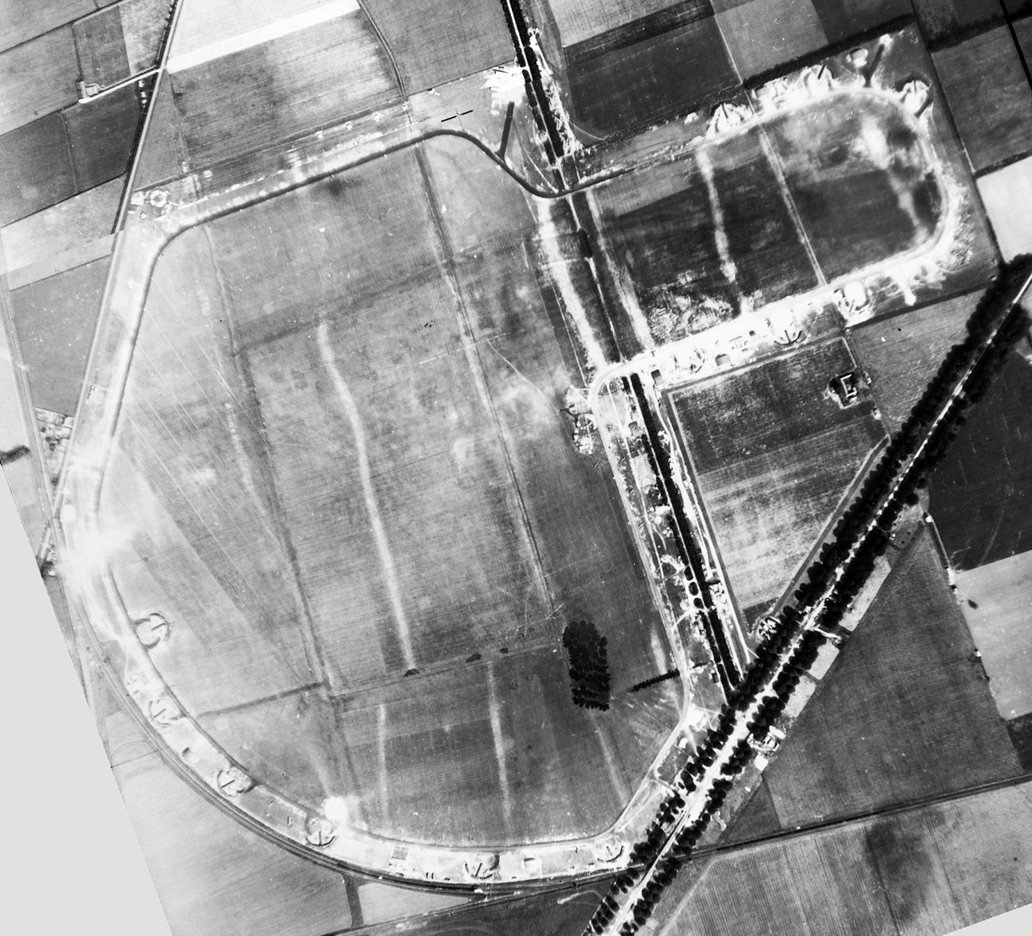
RAF Snailwell

Royal Air Force Snailwell or more simply RAF Snailwell is a former Royal Air Force station located near to the village of Snailwell, Cambridgeshire, located...

Related Videos

Nearby Amenities

Located within 500m of 52.264312,0.39229147
Motorway Junction
Exning Interchange
Exit To: Ely;Newmarket
Ref: 37
Lat/Long: 52.266435/0.3866287
Barrier: bollard
Lat/Long: 52.2617139/0.3892815
Barrier: cycle_barrier
Lat/Long: 52.2604865/0.3900887
Post Box
Collection Times: Mo-Fr 16:15; Sa 11:30
Operator: Royal Mail
Operator Wikidata: Q638098
Post Box Design: type_a
Post Box Type: pillar
Ref: CB8 25
Royal Cypher: EIIR
Royal Cypher Wikidata: Q33102113
Source: survey
Lat/Long: 52.261605/0.3879026
Community Centre
Studlands Park Sports and Social Club
Lat/Long: 52.2653204/0.3871102
Atm
Lat/Long: 52.2608241/0.3967804
Fast Food
Burger King
Addr City: Newmarket
Addr Postcode: CB8 7SX
Addr Street: Oaks Drive
Brand: Burger King
Brand Wikidata: Q177054
Brand Wikipedia: en:Burger King
Contact Website: https://locations.burgerking.co.uk/newmarket/oaks-drive-fordham-road
Cuisine: burger
Drive Through: yes
Facebook: https://www.facebook.com/Burger-King-140725352658941/
Fhrs Id: 1674176
Source Addr: FHRS Open Data
Takeaway: yes
Lat/Long: 52.2629992/0.3977471
Bus Stop
Persimmon Walk
Bus: yes
Naptan AtcoCode: 390020225
Naptan Bearing: W
Naptan CommonName: Persimmon Walk
Naptan Indicator: opp
Naptan Landmark: Persimmon Walk
Naptan NaptanCode: sufajmwg
Naptan Street: Studlands Park Avenue
Naptan Verified: no
Public Transport: platform
Source: naptan_import
Lat/Long: 52.2630315/0.3951178
Bus Stop
Persimmon Walk
Bus: yes
Naptan AtcoCode: 390020226
Naptan Bearing: E
Naptan CommonName: Persimmon Walk
Naptan Indicator: adj
Naptan Landmark: Persimmon Walk
Naptan NaptanCode: sufajmwj
Naptan Street: Studlands Park Avenue
Naptan Verified: no
Public Transport: platform
Source: naptan_import
Lat/Long: 52.2631/0.3951079
Bus Stop
Vincent Close
Bus: yes
Naptan AtcoCode: 390020227
Naptan Bearing: N
Naptan CommonName: Vincent Close
Naptan Indicator: adj
Naptan Landmark: Vincent Close
Naptan NaptanCode: sufajmwm
Naptan Street: Hyperion Way
Naptan Verified: no
Public Transport: platform
Source: naptan_import
Lat/Long: 52.2636122/0.3926429
Bus Stop
Vincent Close
Bus: yes
Naptan AtcoCode: 390020228
Naptan Bearing: S
Naptan BusStopType: CUS
Naptan CommonName: Vincent Close
Naptan Indicator: opp
Naptan Landmark: Vincent Close
Naptan NaptanCode: sufajmwp
Naptan Street: Hyperion Way
Naptan Verified: no
Public Transport: platform
Source: naptan_import
Lat/Long: 52.2636548/0.3927624
Bus Stop
Studland Park Centre
Bus: yes
Naptan AtcoCode: 390020229
Naptan Bearing: E
Naptan CommonName: Studland Park Centre
Naptan Indicator: adj
Naptan Landmark: Studland Park Centre
Naptan NaptanCode: sufajmwt
Naptan Street: Hyperion Way
Naptan Verified: no
Public Transport: platform
Source: naptan_import
Lat/Long: 52.2655353/0.3887159
Bus Stop
Studland Park Centre
Bus: yes
Naptan AtcoCode: 390020230
Naptan Bearing: W
Naptan BusStopType: CUS
Naptan CommonName: Studland Park Centre
Naptan Indicator: opp
Naptan Landmark: Studland Park Centre
Naptan NaptanCode: sufajpad
Naptan Street: Hyperion Way
Naptan Verified: no
Public Transport: platform
Source: naptan_import
Lat/Long: 52.2654266/0.388754
Bus Stop
Community Centre
Bus: yes
Naptan AtcoCode: 390020233
Naptan Bearing: S
Naptan CommonName: Community Centre
Naptan Indicator: adj
Naptan Landmark: Community Centre
Naptan NaptanCode: sufajpam
Naptan Street: Brickfields Avenue
Naptan Verified: no
Public Transport: platform
Source: naptan_import
Lat/Long: 52.2618298/0.3865011
Bus Stop
opp Community Centre
Bus: yes
Naptan AtcoCode: 390020450
Naptan Bearing: N
Naptan CommonName: opp Community Cemtre
Naptan Indicator: opp
Naptan Landmark: Community Centre
Naptan NaptanCode: sufjtgpm
Naptan Verified: no
Public Transport: platform
Source: naptan_import
Lat/Long: 52.261915/0.3862819
Barrier: cycle_barrier
Lat/Long: 52.2605664/0.3898701
Crossing
Crossing: unmarked
Crossing Island: no
Crossing Markings: no
Tactile Paving: no
Lat/Long: 52.2626662/0.396703
Post Box
Collection Times: Mo-Fr 16:15; Sa 11:30
Operator: Royal Mail
Operator Wikidata: Q638098
Post Box Type: lamp
Ref: CB8 26
Royal Cypher: EIIR
Royal Cypher Wikidata: Q33102113
Source: survey
Lat/Long: 52.2647064/0.3917934
Pharmacy
Addr Postcode: CB8 7AH
Lat/Long: 52.2610062/0.3962911
Screwfix
Brand: Screwfix
Brand Wikidata: Q7439115
Brand Wikipedia: en:Screwfix
Shop: doityourself
Website: https://www.screwfix.com/stores/AA5/newmarket
Lat/Long: 52.2610443/0.3903743
Fixme: needs survey
Lat/Long: 52.2644208/0.3868105
Fixme: needs survey
Lat/Long: 52.2627317/0.3874739
Crossing
Crossing: uncontrolled
Crossing Island: no
Crossing Markings: zebra
Tactile Paving: no
Lat/Long: 52.2629924/0.3969783
Crossing
Crossing: uncontrolled
Crossing Island: no
Crossing Markings: zebra
Tactile Paving: no
Lat/Long: 52.2629447/0.3967752
Crossing
Crossing: uncontrolled
Crossing Island: no
Crossing Markings: zebra
Tactile Paving: no
Lat/Long: 52.2628947/0.3965643
Advertising: totem
Operator: Burger King
Visibility: area
Lat/Long: 52.2630577/0.3979726
Advertising: billboard
Lit: no
Operator: Burger King
Support: ground
Visibility: street
Lat/Long: 52.2632124/0.3976824
Advertising: totem
Operator: Studlands Retail Park
Visibility: street
Lat/Long: 52.2627395/0.3975404
Waste Basket
Colour: silver
Material: metal
Waste: trash
Lat/Long: 52.2627842/0.3972046
Waste Basket
Colour: silver
Material: metal
Waste: trash
Lat/Long: 52.2627022/0.3972568
Crossing
Crossing: unmarked
Crossing Island: no
Crossing Markings: no
Tactile Paving: no
Lat/Long: 52.2628114/0.3973494
Crossing
Crossing: unmarked
Crossing Island: no
Crossing Markings: no
Tactile Paving: no
Lat/Long: 52.2627629/0.3971287
Crossing
Crossing: unmarked
Crossing Island: no
Crossing Markings: no
Tactile Paving: no
Lat/Long: 52.2627146/0.3969127
Crossing
Crossing: unmarked
Crossing Island: no
Crossing Markings: no
Tactile Paving: no
Lat/Long: 52.2627313/0.3973673
Crossing
Crossing: unmarked
Crossing Island: no
Crossing Markings: no
Tactile Paving: no
Lat/Long: 52.2626777/0.3971293
Crossing
Crossing: unmarked
Crossing Island: no
Crossing Markings: no
Tactile Paving: no
Lat/Long: 52.2626222/0.3968878
Crossing
Crossing: unmarked
Crossing Markings: no
Lat/Long: 52.2632453/0.3973216
Crossing
Crossing: unmarked
Crossing Markings: no
Lat/Long: 52.2632128/0.3974811
The data included in this document is from www.openstreetmap.org. The data is made available under ODbL.

Have you been to Studlands Park?

Leave your review of Studlands Park below (or comments, questions and feedback).