Scotland

Settlement in Yorkshire

England

Scotland

Airport Leeds Bradford airport, from Plane Tree Hill
Airport Credit: David Johnston

Scotland, Yorkshire is a historic county located in the northern part of England. It covers an area of approximately 2,941 square miles (7,610 square kilometers) and is bordered by the counties of North Yorkshire, West Yorkshire, and South Yorkshire. The region is known for its scenic landscapes, picturesque villages, and rich cultural heritage.

Scotland, Yorkshire is home to several prominent cities and towns, including Leeds, Bradford, Sheffield, and York. These urban centers offer a vibrant mix of modern amenities and historic landmarks. For example, York is renowned for its well-preserved medieval city walls and Gothic cathedral, while Leeds is known for its thriving arts scene and impressive Victorian architecture.

The countryside of Scotland, Yorkshire is characterized by rolling hills, lush valleys, and picturesque moorlands. The Yorkshire Dales National Park, located in the western part of the county, attracts nature enthusiasts with its stunning scenery, hiking trails, and charming villages. The North York Moors National Park, to the east, offers a similar appeal with its heather-covered moorlands and ancient woodlands.

Scotland, Yorkshire is also famous for its cultural offerings. The region boasts numerous museums, art galleries, and theaters, showcasing its rich history and artistic talents. Additionally, it is renowned for its annual events and festivals, such as the York Festival of Ideas and the Leeds International Film Festival.

Overall, Scotland, Yorkshire offers a diverse range of attractions for both locals and visitors alike, combining natural beauty, historic landmarks, and a vibrant cultural scene.

If you have any feedback on the listing, please let us know in the comments section below.

Scotland Images

Images are sourced within 2km of 53.857797/-1.641983 or Grid Reference SE2340. Thanks to Geograph Open Source API. All images are credited.

Airport Leeds Bradford airport, from Plane Tree Hill
Airport
Leeds Bradford airport, from Plane Tree Hill
Moseley Bottom The  entrance to the railway tunnel at Moseley Bottom on the Leeds to Harrogate line
Moseley Bottom
The entrance to the railway tunnel at Moseley Bottom on the Leeds to Harrogate line
Scotland, Yorkshire An old cottage and adjoining stable at the hamlet of Scotland, the hamlet is directly under the flight path from Leeds Bradford Airport.
Scotland, Yorkshire
An old cottage and adjoining stable at the hamlet of Scotland, the hamlet is directly under the flight path from Leeds Bradford Airport.
Sheep pastures behind The Billing The view southwest from Bayton Lane contrasts with the northeast side of the gridsquare (part of Leeds-Bradford Airport).
Sheep pastures behind The Billing
The view southwest from Bayton Lane contrasts with the northeast side of the gridsquare (part of Leeds-Bradford Airport).
Tower at Leeds Bradford Airport Old tower midway along the southwestern periphery of the airport, off Bayton Lane.
Tower at Leeds Bradford Airport
Old tower midway along the southwestern periphery of the airport, off Bayton Lane.
Trig point at Plane Tree Hill The trig point has had a wall built up against it and is visible at the wall's left end. This area behind Leeds Bradford Airport is used for impromptu motorsport (despite police notices). The map calls this Plane Tree Hill; it has plenty of planes, but few trees.
Trig point at Plane Tree Hill
The trig point has had a wall built up against it and is visible at the wall's left end. This area behind Leeds Bradford Airport is used for impromptu motorsport (despite police notices). The map calls this Plane Tree Hill; it has plenty of planes, but few trees.
Crag Hill, Bramhope Moor Pasture land viewed southwards from Old Road.
Crag Hill, Bramhope Moor
Pasture land viewed southwards from Old Road.
Air shaft, Bramhope Tunnel Bramhope Tunnel is on the Leeds to Harrogate railway line. The tunnel is over two miles long and was constructed from 1845 to 1849 at a cost of 24 lives. There are four of these shafts, and also a sighting tower survives (SE2442).  See the excellent description at <span class="nowrap"><a title="http://www.bramhope.org/brtunnel.htm" rel="nofollow ugc noopener" href="http://www.bramhope.org/brtunnel.htm">Link</a><img style="margin-left:2px;" alt="External link" title="External link - shift click to open in new window" src="https://s1.geograph.org.uk/img/external.png" width="10" height="10"/></span>
Air shaft, Bramhope Tunnel
Bramhope Tunnel is on the Leeds to Harrogate railway line. The tunnel is over two miles long and was constructed from 1845 to 1849 at a cost of 24 lives. There are four of these shafts, and also a sighting tower survives (SE2442). See the excellent description at LinkExternal link
Long stay car park, Leeds Bradford Airport Adjacent to Whitehouse Lane.
Long stay car park, Leeds Bradford Airport
Adjacent to Whitehouse Lane.
Cookridge Methodist Church, Tinshill Road, Cookridge, Leeds The church is near the junction of Tinshill Road and Otley Old Road. This is the view from Tinshill Road looking south-east
Cookridge Methodist Church, Tinshill Road, Cookridge, Leeds
The church is near the junction of Tinshill Road and Otley Old Road. This is the view from Tinshill Road looking south-east
Scotland Scotland Lane as it passes through the hamlet of Scotland, by the entrance to Moor Grange Farm.
Scotland
Scotland Lane as it passes through the hamlet of Scotland, by the entrance to Moor Grange Farm.
Approach lights, Leeds Bradford Airport The final approach lights at the south-east end of the main runway (runway 32) at Leeds Bradford International Airport. A light aircraft coming in to land over the lights.
Approach lights, Leeds Bradford Airport
The final approach lights at the south-east end of the main runway (runway 32) at Leeds Bradford International Airport. A light aircraft coming in to land over the lights.
Approach lights, Leeds Bradford Airport Looking south-east, with the end of runway 32 behind my right side.
Approach lights, Leeds Bradford Airport
Looking south-east, with the end of runway 32 behind my right side.
Reservoir and pump house(?) On the right is a small covered reservoir. The building presumably houses pumps and so on.
Reservoir and pump house(?)
On the right is a small covered reservoir. The building presumably houses pumps and so on.
Stone stile and broken gate On the private road / public footpath from Scotland Lane, past the stable and houses at <a href="https://www.geograph.org.uk/photo/20878">SE2340 : Scotland, Yorkshire</a>, leading to the reservoir <a href="https://www.geograph.org.uk/photo/328420">SE2340 : Reservoir and pump house(?)</a>. The post by the stile has a "Public Footpath" sign at the top.
Stone stile and broken gate
On the private road / public footpath from Scotland Lane, past the stable and houses at SE2340 : Scotland, Yorkshire, leading to the reservoir SE2340 : Reservoir and pump house(?). The post by the stile has a "Public Footpath" sign at the top.
Very early daffodils, Scotland, Yorkshire By the entrance to Moor Grange on Scotland Lane, in the hamlet of Scotland near Horsforth.
Very early daffodils, Scotland, Yorkshire
By the entrance to Moor Grange on Scotland Lane, in the hamlet of Scotland near Horsforth.
The lane to Owlet Farm Looking down from Scotland Lane
The lane to Owlet Farm
Looking down from Scotland Lane
Scotland Beck Looking down from Scotland Lane as the Beck flows into the culvert under the road.
Scotland Beck
Looking down from Scotland Lane as the Beck flows into the culvert under the road.
Show me another place!

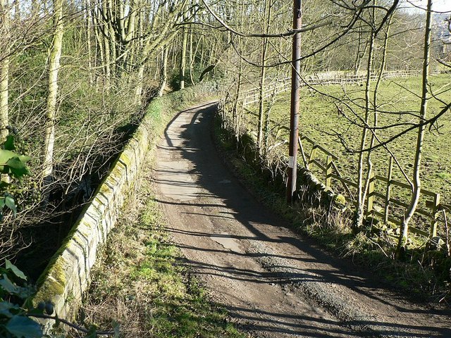
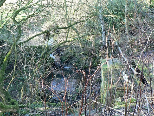
Scotland is located at Grid Ref: SE2340 (Lat: 53.857797, Lng: -1.641983)

Division: West Riding

Unitary Authority: Leeds

Police Authority: West Yorkshire

What 3 Words

///names.rarely.talent. Near Horsforth, West Yorkshire

Nearby Locations

Scotland

Related Wikis

Related Videos

Walking Around Newlay Bridge / Riverside Walk Horsforth October 2020

Join me as I take a short stroll through Horsforth and explore the Newlay Bridge area! New video everyday 8pm GMT! Follow me ...

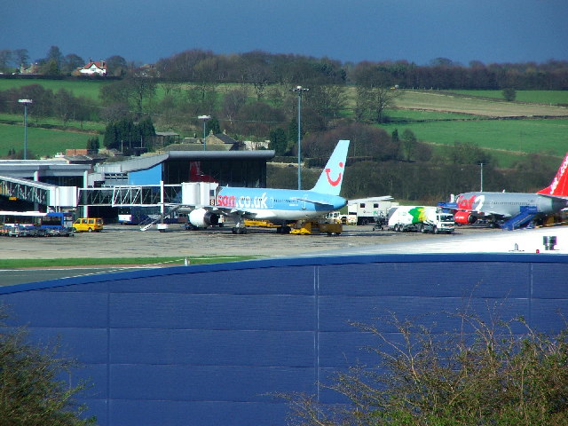
Christy & Seb's Tenerife Travel Day | 10/04/22 | Flying From Leeds Bradford Airport With JET2!!

Follow Christy & Seb on their travel day from travelling though Leeds Bradford airport to arriving in Tenerife. We booked through ...

Tenerife South Trip #tenerife #tenerifesouth #travel #holiday #airport

Travelling To Tenerife South From Leeds Bradford Airport.

Nearby Amenities

Located within 500m of 53.857797,-1.641983
Access: no
Barrier: kissing_gate
Foot: yes
Lat/Long: 53.8597314/-1.63693
Turning Circle
Lat/Long: 53.8534583/-1.641024
Turning Circle
Lat/Long: 53.8536817/-1.6437456
Aeroway: navigationaid
Man Made: beacon
Navigationaid: als
Source: Bing
Lat/Long: 53.8566543/-1.6463983
Aeroway: navigationaid
Man Made: beacon
Navigationaid: als
Source: Bing
Lat/Long: 53.8581324/-1.6486578
Aeroway: navigationaid
Man Made: beacon
Navigationaid: als
Source: Bing
Lat/Long: 53.8554615/-1.6445747
Aeroway: navigationaid
Man Made: beacon
Navigationaid: als
Source: Bing
Lat/Long: 53.8559714/-1.6453542
Aeroway: navigationaid
Man Made: beacon
Navigationaid: als
Source: Bing
Lat/Long: 53.8578692/-1.6482555
Aeroway: navigationaid
Man Made: beacon
Navigationaid: als
Source: Bing
Lat/Long: 53.858594/-1.6493635
Aeroway: navigationaid
Man Made: beacon
Navigationaid: als
Source: Bing
Lat/Long: 53.8557944/-1.6450836
Aeroway: navigationaid
Man Made: beacon
Navigationaid: als
Source: Bing
Lat/Long: 53.8563129/-1.6458763
Aeroway: navigationaid
Man Made: beacon
Navigationaid: als
Source: Bing
Lat/Long: 53.858401/-1.6490684
Aeroway: navigationaid
Man Made: beacon
Navigationaid: als
Source: Bing
Lat/Long: 53.8549497/-1.6437924
Aeroway: navigationaid
Man Made: beacon
Navigationaid: als
Source: Bing
Lat/Long: 53.8561448/-1.6456193
Aeroway: navigationaid
Man Made: beacon
Navigationaid: als
Source: Bing
Lat/Long: 53.8570269/-1.6469679
Aeroway: navigationaid
Man Made: beacon
Navigationaid: als
Source: Bing
Lat/Long: 53.8552952/-1.6443205
Aeroway: navigationaid
Man Made: beacon
Navigationaid: als
Source: Bing
Lat/Long: 53.8564842/-1.6461382
Aeroway: navigationaid
Man Made: beacon
Navigationaid: als
Source: Bing
Lat/Long: 53.8575512/-1.6477694
Aeroway: navigationaid
Man Made: beacon
Navigationaid: als
Source: Bing
Lat/Long: 53.8551162/-1.6440469
Aeroway: navigationaid
Man Made: beacon
Navigationaid: als
Source: Bing
Lat/Long: 53.8556296/-1.6448317
Post Box
Brand: Royal Mail
Brand Wikidata: Q638098
Brand Wikipedia: en:Royal Mail
Operator: Royal Mail
Operator Wikidata: Q638098
Post Box Type: wall
Ref: LS18 49
Royal Cypher: GVIR
Royal Cypher Wikidata: Q33102169
Lat/Long: 53.8586682/-1.6415234
Aeroway: navigationaid
Man Made: beacon
Navigationaid: als
Source: Bing
Lat/Long: 53.8568262/-1.6466234
Airmark: beacon
Beacon Type: ILS
Localizer: yes
Ref: I-LBF
Runway Ref: 14
Lat/Long: 53.8580878/-1.6485901
Turning Circle
Lat/Long: 53.8544355/-1.6415335
Access: no
Barrier: stile
Foot: yes
Material: wood
Stile: stepover
Lat/Long: 53.8584739/-1.6369566
Power: pole
Lat/Long: 53.8563088/-1.6348208
Power: pole
Lat/Long: 53.8562668/-1.636012
Material: wood
Power: pole
Lat/Long: 53.8562165/-1.637195
Power: pole
Lat/Long: 53.8564419/-1.6380081
Power: pole
Lat/Long: 53.8566601/-1.6388029
Power: pole
Lat/Long: 53.8569694/-1.6399839
Power: pole
Lat/Long: 53.8572979/-1.6412089
Barrier: stile
Material: stone
Stile: stepover
Lat/Long: 53.8573861/-1.6438365
Barrier: stile
Foot: yes
Stile: stepover
Lat/Long: 53.8578284/-1.6420586
Barrier: stile
Lat/Long: 53.8564277/-1.6466685
Aeroway: navigationaid
Man Made: beacon
Navigationaid: als
Source: Bing
Lat/Long: 53.8577119/-1.648019
Access: no
Barrier: stile
Foot: yes
Material: stone
Stile: squeezer
Lat/Long: 53.8574706/-1.6374215
The data included in this document is from www.openstreetmap.org. The data is made available under ODbL.

Have you been to Scotland?

Leave your review of Scotland below (or comments, questions and feedback).