Sampool

Settlement in Westmorland South Lakeland

England

Sampool

Stall by the car park Walk over Whitbarrow and purchase a postcard or a local walks booklet.
Stall by the car park Credit: Karl and Ali

Sampool is a small rural village located in the district of Westmorland, England. It is situated in the picturesque and idyllic Lake District, surrounded by rolling hills and stunning natural landscapes. With a population of approximately 300 residents, Sampool is known for its tight-knit community and tranquil atmosphere.

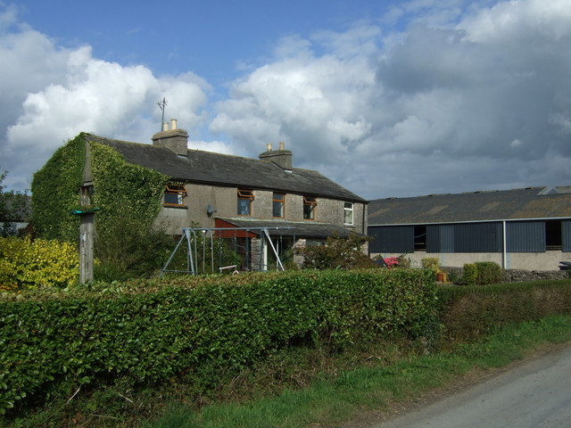
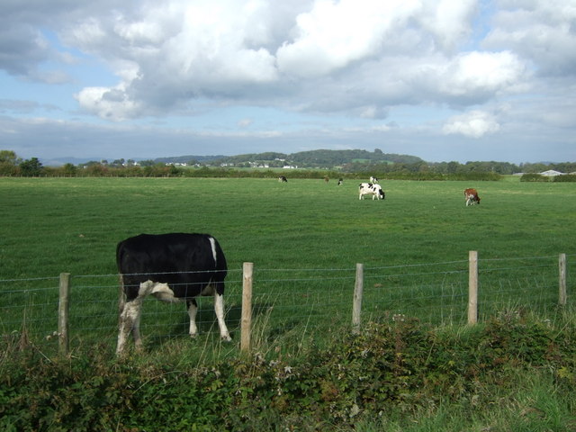
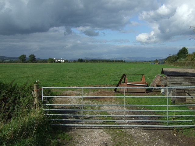
The village is characterized by its traditional architecture, with charming stone houses and cottages dotting the picturesque streets. The local economy mainly revolves around agriculture, with farming being a prominent occupation in the area. The fertile land surrounding Sampool allows for the cultivation of various crops and the rearing of livestock.

Sampool is blessed with an abundance of natural beauty, making it an attractive destination for nature lovers and outdoor enthusiasts. The village is located in close proximity to several popular tourist attractions, including Lake Windermere, England's largest lake, and the stunning peaks of the Lake District National Park.

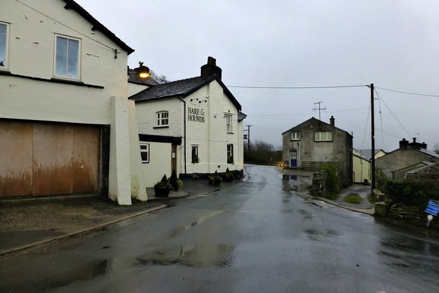
Despite its small size, Sampool boasts a range of amenities to cater to the needs of its residents. These include a village hall, a primary school, a local pub, and a few small shops. The village also hosts regular community events and festivals, fostering a strong sense of community spirit.

In summary, Sampool is a peaceful and picturesque village nestled in the heart of the Westmorland district. With its rich natural landscapes and close-knit community, it offers a tranquil and charming environment for residents and visitors alike.

If you have any feedback on the listing, please let us know in the comments section below.

Sampool Images

Images are sourced within 2km of 54.261506/-2.8097535 or Grid Reference SD4785. Thanks to Geograph Open Source API. All images are credited.

Stall by the car park Walk over Whitbarrow and purchase a postcard or a local walks booklet.
Stall by the car park
Walk over Whitbarrow and purchase a postcard or a local walks booklet.
Interior of derelict building below White Scar The building was probably part of the quarrying operation which removed talus from the flank of White Scar.
Interior of derelict building below White Scar
The building was probably part of the quarrying operation which removed talus from the flank of White Scar.
College Green
College Green
Grazing near College Green
Field entrance, College Green
White Scar, Whitbarrow The great buttress of White Scar forms the southern escarpment of Whitbarrow. It is one of the most impressive limestone crags in the UK and home to several high standard rock climbs. Since access is currently banned and actually reaching the foot of the climbs is fraught with danger, these have never become popular.
White Scar, Whitbarrow
The great buttress of White Scar forms the southern escarpment of Whitbarrow. It is one of the most impressive limestone crags in the UK and home to several high standard rock climbs. Since access is currently banned and actually reaching the foot of the climbs is fraught with danger, these have never become popular.
The bedding plane slab below White Scar Heading up the tilted slab exposed by quarrying of the scree slope that once formed the slope below the limestone scar. It might be a skateboarders heaven?
The bedding plane slab below White Scar
Heading up the tilted slab exposed by quarrying of the scree slope that once formed the slope below the limestone scar. It might be a skateboarders heaven?
The Hare and Hounds Typical of a village pub that has survived this is more of a restaurant than a pub now.  I'd had a very pleasant meal here the previous evening and had had to return in order to retrieve my camera, which I'd left behind.
The Hare and Hounds
Typical of a village pub that has survived this is more of a restaurant than a pub now. I'd had a very pleasant meal here the previous evening and had had to return in order to retrieve my camera, which I'd left behind.
Levens Lane The road linking the A590 with the village of Levens
Levens Lane
The road linking the A590 with the village of Levens
Bridge for farm traffic and footpath over A590 Bridge giving access to Low Levens Farm
Bridge for farm traffic and footpath over A590
Bridge giving access to Low Levens Farm
Woodland at Stakes Moss
Lay-by by A590 near Mill Side With the "Bees Knees" snack bar trailer
Lay-by by A590 near Mill Side
With the "Bees Knees" snack bar trailer
Whitbarrow seen from Sandside The White Scar cliff on the east side of Whitbarrow hill, towering over the River Kent estuary in south Cumbria. Seen from Sandside near Storth in January 1976.
Whitbarrow seen from Sandside
The White Scar cliff on the east side of Whitbarrow hill, towering over the River Kent estuary in south Cumbria. Seen from Sandside near Storth in January 1976.
Main Drain, Rawson's Moss Drainage channel on the west side of the Lyth Valley, which extends south to Foulshaw Moss.
Looking north to Gilpin Farm, with the limestone ridge of Helsington Barrows and Scout Scar in the distance.
Main Drain, Rawson's Moss
Drainage channel on the west side of the Lyth Valley, which extends south to Foulshaw Moss. Looking north to Gilpin Farm, with the limestone ridge of Helsington Barrows and Scout Scar in the distance.
Levens Lane nearing the A590
A590 near Sampool Bridge
A590 near Parkside Cottage
A590 near Stakes Moss
Show me another place!

Sampool is located at Grid Ref: SD4785 (Lat: 54.261506, Lng: -2.8097535)

Administrative County: Cumbria

District: South Lakeland

Police Authority: Cumbria

What 3 Words

///painted.reactions.pays. Near Milnthorpe, Cumbria

Nearby Locations

Sampool Sampool Plain

Related Wikis

Causeway End

Causeway End is a hamlet in Cumbria, England.

River Gilpin

The River Gilpin is a river in the English county of Cumbria. Formerly, the river was in the county of Westmorland. The river rises near Gilpin Lodge in...

Levens, Cumbria

Levens is a village and civil parish in Westmorland and Furness, Cumbria. It lies within the historic county of Westmorland. In the 2001 census the parish...

Cotes, Cumbria

Cotes is a hamlet in Cumbria, England. == References ==

Nearby Amenities

Located within 500m of 54.261506,-2.8097535
Give Way
Direction: forward
Lat/Long: 54.2617092/-2.80886
Bus Stop
Sampool Bridge (E bound)
Bench: no
Bin: no
Bus: yes
Local Ref: AT
Naptan AtcoCode: 090079431521
Naptan Bearing: E
Naptan BusStopType: CUS
Naptan CommonName: Sampool Bridge (E bound)
Naptan Indicator: at
Naptan Landmark: River Gilpin Bridge
Naptan NaptanCode: cumdjwtm
Naptan Street: A590(T)
Naptan Verified: no
Public Transport: platform
Shelter: no
Source: naptan_import
Lat/Long: 54.2612627/-2.8112033
Bus Stop
Sampool Bridge (W bound)
Bench: no
Bin: no
Bus: yes
Naptan AtcoCode: 090079431522
Naptan Bearing: W
Naptan BusStopType: CUS
Naptan CommonName: Sampool Bridge (W bound)
Naptan Indicator: w/bound
Naptan Landmark: River Gilpin Bridge
Naptan NaptanCode: cumdjwtp
Naptan Street: A590(T)
Naptan Verified: no
Public Transport: platform
Shelter: no
Source: naptan_import
Lat/Long: 54.261096/-2.8106012
Power: tower
Lat/Long: 54.2647342/-2.8149409
Give Way
Direction: backward
Lat/Long: 54.2619672/-2.8125577
Waterway: sluice_gate
Lat/Long: 54.2605942/-2.8125367
Waterway: sluice_gate
Lat/Long: 54.260571/-2.8126241
Waterway: sluice_gate
Lat/Long: 54.2606157/-2.8124568
Post Box
Collection Times: Mo-Fr 16:00; Sa 11:00
Drive Through: no
Post Box Type: lamp
Ref: LA8 131
Royal Cypher: EIIR
Royal Cypher Wikidata: Q33102113
Lat/Long: 54.2619666/-2.81099
Give Way
Direction: backward
Lat/Long: 54.2607406/-2.8132257
Give Way
Direction: forward
Lat/Long: 54.2608667/-2.8134492
Give Way
Direction: forward
Lat/Long: 54.2597485/-2.8157882
Give Way
Direction: backward
Lat/Long: 54.2613345/-2.8096663
Parking
Access: yes
Fee: no
Park Ride: no
Parking: layby
Supervised: no
Surface: asphalt
Lat/Long: 54.2627402/-2.8127581
Give Way
Direction: backward
Lat/Long: 54.2618347/-2.8095784
Barrier: stile
Lat/Long: 54.2639307/-2.8095729
Give Way
Direction: forward
Lat/Long: 54.2650767/-2.8079009
Sampool Bridge (W bound)
Bus: yes
Public Transport: stop_position
Lat/Long: 54.2611533/-2.8106353
Sampool Bridge (E bound)
Bus: yes
Public Transport: stop_position
Lat/Long: 54.2611984/-2.811172
Crossing
Crossing: unmarked
Crossing Island: no
Crossing Markings: no
Tactile Paving: no
Lat/Long: 54.2600924/-2.8157023
Barrier: cycle_barrier
Bicycle: yes
Cycle Barrier: double
Foot: yes
Motor Vehicle: no
Lat/Long: 54.2600646/-2.8158026
Barrier: cycle_barrier
Bicycle: yes
Cycle Barrier: double
Foot: yes
Motor Vehicle: no
Lat/Long: 54.2601165/-2.815635
Power: pole
Lat/Long: 54.2636942/-2.8152846
Power: pole
Lat/Long: 54.2630283/-2.8149237
Power: pole
Lat/Long: 54.2623375/-2.8145704
Power: pole
Lat/Long: 54.2623126/-2.8129392
Power: pole
Lat/Long: 54.2622951/-2.811779
Power: pole
Lat/Long: 54.2573158/-2.8117339
Power: pole
Lat/Long: 54.2584955/-2.8117014
Power: pole
Lat/Long: 54.259062/-2.8109446
Power: pole
Lat/Long: 54.2595801/-2.8102505
Power: pole
Lat/Long: 54.2601319/-2.8094763
Power: pole
Lat/Long: 54.2604568/-2.8080004
Power: pole
Lat/Long: 54.2607759/-2.8065045
Power: pole
Lat/Long: 54.2610057/-2.8054521
Power: pole
Lat/Long: 54.2614711/-2.8038008
Power: pole
Lat/Long: 54.2583426/-2.8133764
Power: pole
Lat/Long: 54.2582079/-2.8148749
The data included in this document is from www.openstreetmap.org. The data is made available under ODbL.

Have you been to Sampool?

Leave your review of Sampool below (or comments, questions and feedback).