Rhos

Settlement in Shropshire

England

Rhos

Gate in the Wall This was previously well hidden behind some overgrown Laurels.
Gate in the Wall Credit: Eric Marsh

Rhos is a quaint village located in the county of Shropshire, England. Situated in the beautiful Welsh Marches, Rhos is nestled in the borderlands between England and Wales. The village is part of the historic parish of Chirkland and is surrounded by stunning countryside and rolling hills.

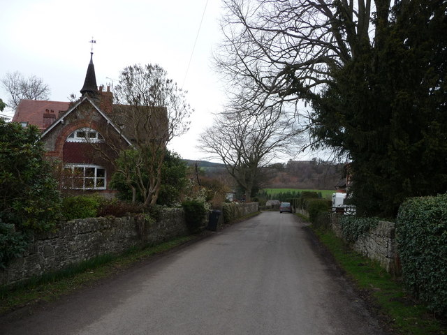
Rhos is a small, close-knit community with a population of around 500 residents. The village is characterized by its charming stone houses and narrow lanes, giving it a traditional and idyllic atmosphere. The local economy is primarily based on agriculture, with many residents working in farming or related industries.

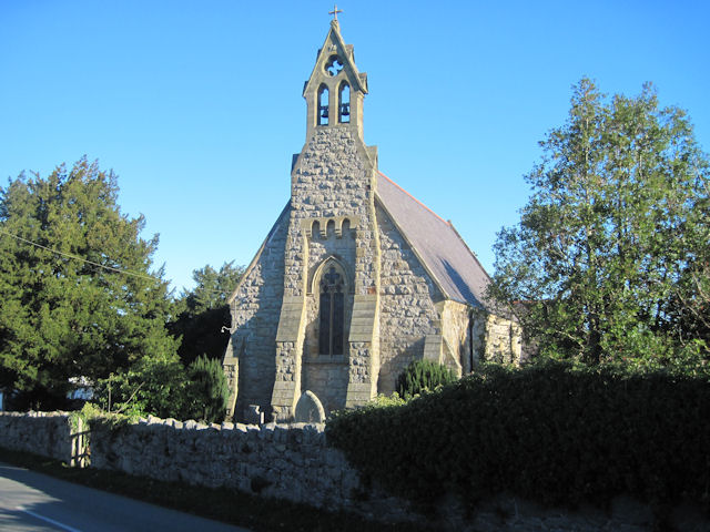
The heart of the village is centered around St. John the Baptist Church, a beautiful medieval church that dates back to the 14th century. This historic landmark is an important focal point for the community and provides a sense of heritage and tradition.

The village also boasts a well-regarded primary school, providing education to the local children. Additionally, Rhos has a village hall, which serves as a hub for community events, gatherings, and celebrations.

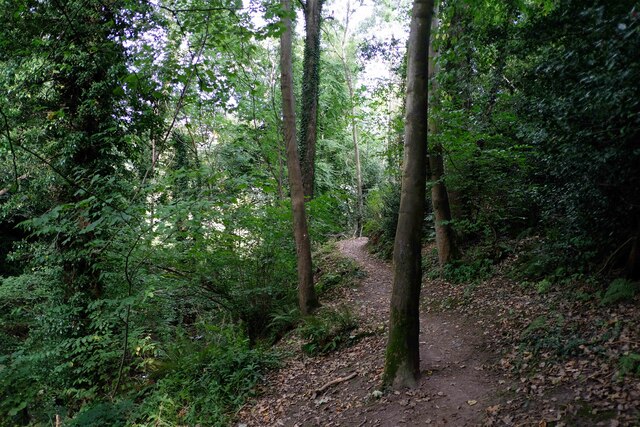
Rhos benefits from its proximity to the stunning countryside, offering residents and visitors ample opportunities for outdoor activities such as hiking, cycling, and exploring the nearby Clwydian Range and Berwyn Mountains.

Although small in size, Rhos is a charming and welcoming village that offers a peaceful and picturesque lifestyle. Its rich history, strong sense of community, and stunning natural surroundings make it a desirable place to live or visit.

If you have any feedback on the listing, please let us know in the comments section below.

Rhos Images

Images are sourced within 2km of 52.91436/-3.0825088 or Grid Reference SJ2735. Thanks to Geograph Open Source API. All images are credited.

Gate in the Wall This was previously well hidden behind some overgrown Laurels.
Gate in the Wall
This was previously well hidden behind some overgrown Laurels.
Farm sheds near Upper Hengoed
Minor road near Weston Hall
Field near Mardy
Field near Mardy
Ordnance Survey Cut Mark This OS cut mark can be found on Weston Rhyn Station House. It marks a point 111.145m above mean sea level.
Ordnance Survey Cut Mark
This OS cut mark can be found on Weston Rhyn Station House. It marks a point 111.145m above mean sea level.
Ordnance Survey Cut Mark This OS cut mark can be found on the Institute building on the cross roads. It marks a point 127.257m above mean sea level.
Ordnance Survey Cut Mark
This OS cut mark can be found on the Institute building on the cross roads. It marks a point 127.257m above mean sea level.
Ordnance Survey Flush Bracket (G3019) This OS Flush Bracket can be found on The Cross Keys Inn. It marks a point 232.528m above mean sea level.
Ordnance Survey Flush Bracket (G3019)
This OS Flush Bracket can be found on The Cross Keys Inn. It marks a point 232.528m above mean sea level.
Ordnance Survey Pivot This OS pivot can be found on the south face of St Mary's Church. It marks a point 231.359m above mean sea level.
Ordnance Survey Pivot
This OS pivot can be found on the south face of St Mary's Church. It marks a point 231.359m above mean sea level.
Mile Stone - Oswestry 4 There is an OS cut mark on the stone which marks a point 255.691m above mean sea level.
Mile Stone - Oswestry 4
There is an OS cut mark on the stone which marks a point 255.691m above mean sea level.
The Quinta temple Built by the MP owner of Quinta house in the 1850s, the 'temple' was a Celtic riposte to the fashion for mock-Greek and Roman follies on grand estates. Though it's the first replica of Stonehenge to be built anywhere, I found it comically underwhelming, making me think more of Hammer Horror movies of the 1960s.
The Quinta temple
Built by the MP owner of Quinta house in the 1850s, the 'temple' was a Celtic riposte to the fashion for mock-Greek and Roman follies on grand estates. Though it's the first replica of Stonehenge to be built anywhere, I found it comically underwhelming, making me think more of Hammer Horror movies of the 1960s.
B4500 near Baddy's Wood
Afon Ceiriog at Bronygarth The Afon Ceiriog (River Ceiriog) at Bronygarth.
Afon Ceiriog at Bronygarth
The Afon Ceiriog (River Ceiriog) at Bronygarth.
The Maelor Way at Bronygarth Looking north along the Maelor Way at Bronygarth.

Wikipedia <span class="nowrap"><a title="https://en.wikipedia.org/wiki/Maelor_Way" rel="nofollow ugc noopener" href="https://en.wikipedia.org/wiki/Maelor_Way">Link</a><img style="margin-left:2px;" alt="External link" title="External link - shift click to open in new window" src="https://s1.geograph.org.uk/img/external.png" width="10" height="10"/></span>
The Maelor Way at Bronygarth
Looking north along the Maelor Way at Bronygarth. Wikipedia LinkExternal link
The Maelor Way at Pentre Wood Heading northeast along the Maelor Way through Pentre Wood at Bronygarth.
The Maelor Way at Pentre Wood
Heading northeast along the Maelor Way through Pentre Wood at Bronygarth.
The Maelor Way next to the Afon Ceiriog Heading east along the Maelor Way next to the Afon Ceiriog.

Wikipedia <span class="nowrap"><a title="https://en.wikipedia.org/wiki/Maelor_Way" rel="nofollow ugc noopener" href="https://en.wikipedia.org/wiki/Maelor_Way">Link</a><img style="margin-left:2px;" alt="External link" title="External link - shift click to open in new window" src="https://s1.geograph.org.uk/img/external.png" width="10" height="10"/></span>
The Maelor Way next to the Afon Ceiriog
Heading east along the Maelor Way next to the Afon Ceiriog. Wikipedia LinkExternal link
The Maelor Way near Chirk Heading east along the Maelor Way next to the Afon Ceiriog.

Wikipedia <span class="nowrap"><a title="https://en.wikipedia.org/wiki/Maelor_Way" rel="nofollow ugc noopener" href="https://en.wikipedia.org/wiki/Maelor_Way">Link</a><img style="margin-left:2px;" alt="External link" title="External link - shift click to open in new window" src="https://s1.geograph.org.uk/img/external.png" width="10" height="10"/></span>
The Maelor Way near Chirk
Heading east along the Maelor Way next to the Afon Ceiriog. Wikipedia LinkExternal link
The Maelor Way approaching Pont-faen Heading east towards Pont-faen near Chirk along the Maelor Way.
The Maelor Way approaching Pont-faen
Heading east towards Pont-faen near Chirk along the Maelor Way.
Houses at Pont-faen Houses along a narrow lane at Pont-faen.
Houses at Pont-faen
Houses along a narrow lane at Pont-faen.
Show me another place!

Rhos is located at Grid Ref: SJ2735 (Lat: 52.91436, Lng: -3.0825088)

Unitary Authority: Shropshire

Police Authority: West Merica

What 3 Words

///single.shrimps.advantage. Near Chirk, Wrexham

Related Wikis

Weston Rhyn

Weston Rhyn is a large village and civil parish in Shropshire, England. It lies between the towns of Chirk, in Wales, and Oswestry, in England. The civil...

Bronygarth

Bronygarth is a small village in the Ceiriog Valley near Oswestry in Shropshire, England at grid reference SJ268370. The village is on the England–Wales...

Selattyn and Gobowen

Selattyn and Gobowen is a civil parish in Shropshire, England. The smaller village of Selattyn is in the west of the parish, and the larger village of...

Selattyn

Selattyn (Welsh: Sylatyn) is a village and former civil parish, now in the parish of Selattyn and Gobowen, in the Shropshire district, in the ceremonial...

Nearby Amenities

Located within 500m of 52.91436,-3.0825088
Post Box
Lat/Long: 52.9133844/-3.0767682
Place: farm
Lat/Long: 52.9176577/-3.0845196
Place: farm
Lat/Long: 52.9158075/-3.0835326
Power: pole
Lat/Long: 52.9103805/-3.0805117
Power: pole
Lat/Long: 52.9115063/-3.0806243
Power: pole
Lat/Long: 52.9136381/-3.0808121
Power: pole
Lat/Long: 52.9149967/-3.0809194
Power: pole
Lat/Long: 52.9168243/-3.0811125
Power: pole
Lat/Long: 52.9158863/-3.0810159
Power: pole
Lat/Long: 52.9179402/-3.0812466
Rhos
Place: hamlet
Lat/Long: 52.9145089/-3.08194
Power: pole
Lat/Long: 52.9125706/-3.0807142
The data included in this document is from www.openstreetmap.org. The data is made available under ODbL.

Have you been to Rhos?

Leave your review of Rhos below (or comments, questions and feedback).