Pappert

Settlement in Dunbartonshire

Scotland

Pappert

Yet ANOTHER photo of Christie Park, Alexandria! Christie Park, Alexandria
Yet ANOTHER photo of Christie Park, Alexandria! Credit: coughlan

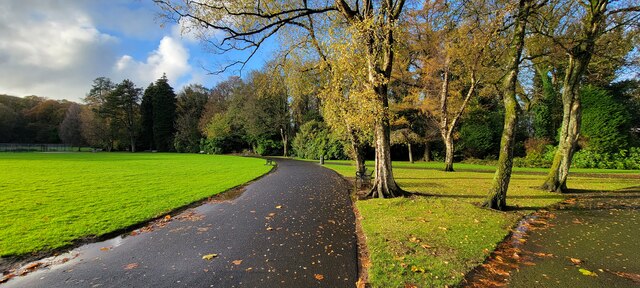
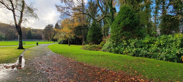
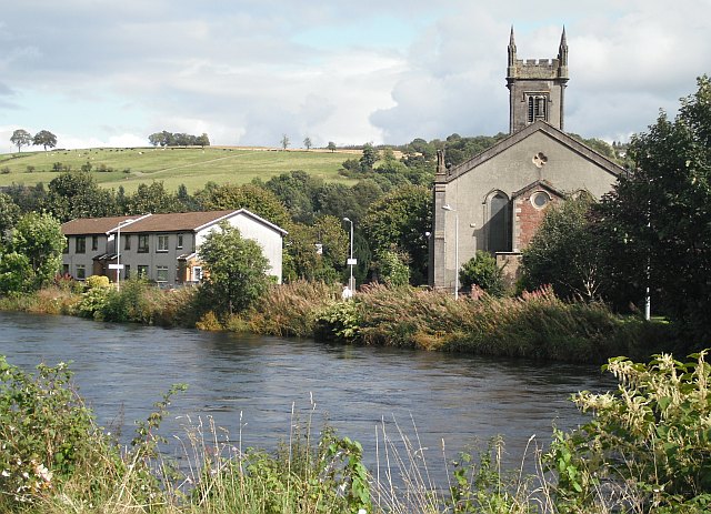
Pappert, Dunbartonshire is a small village located in West Dunbartonshire, Scotland. Situated on the banks of the River Clyde, it is nestled within the picturesque surroundings of the Scottish Lowlands. Pappert is known for its tranquil and idyllic setting, making it a popular destination for those seeking a peaceful retreat from the hustle and bustle of city life.

The village is characterized by its charming traditional Scottish architecture, with quaint stone cottages lining the narrow streets. Pappert is home to a tight-knit community, with friendly locals who take pride in their village's heritage and natural beauty.

Nature enthusiasts are drawn to Pappert due to its proximity to the stunning Loch Lomond and The Trossachs National Park. The park offers a wealth of outdoor activities, including hiking, cycling, and fishing, making Pappert an excellent base for exploring the Scottish countryside.

Despite its rural setting, Pappert is conveniently located near several larger towns and cities. Glasgow, Scotland's largest city, is just a short drive away, providing residents with easy access to a wide range of amenities, including shopping centers, restaurants, and cultural attractions.

In summary, Pappert, Dunbartonshire is a charming village situated in the heart of the Scottish Lowlands. With its scenic location, friendly community, and proximity to both natural beauty and urban conveniences, it offers a harmonious blend of tranquility and accessibility.

If you have any feedback on the listing, please let us know in the comments section below.

Pappert Images

Images are sourced within 2km of 55.981771/-4.5603822 or Grid Reference NS4079. Thanks to Geograph Open Source API. All images are credited.

Yet ANOTHER photo of Christie Park, Alexandria! Christie Park, Alexandria
Yet ANOTHER photo of Christie Park, Alexandria!
Christie Park, Alexandria
Christie Park, Alexandria An Autumn day in the park.
Christie Park, Alexandria
An Autumn day in the park.
Wilson Street, Alexandria
Bonhill and Alexandria St Andrew's Royal Arch Number 321 Bonhill and Alexandria St Andrew's Royal Arch Number 321 on the Roll of The Grand Lodge of Scotland in the Province of Dunbartonshire.

The lodge was established in February 1826 and moved  to its current premises in 1921 when the Ewing Gilmour Institute for girls became available. The construction of the  building began in 1888, which was funded by William Ewing Gilmour, a noted Vale of Leven benefactor, who was a director of the United Turkey Red Company (UTR).   It was originally The Institute for Working Girls. On completion in 1891 it was presented to the Scots Girls' Friendly Society. The architect was J A Campbell.

During World War II the War Department commandeered the building to provide accommodation for some of those whose houses was bombed during the Clydebank blitz.
Bonhill and Alexandria St Andrew's Royal Arch Number 321
Bonhill and Alexandria St Andrew's Royal Arch Number 321 on the Roll of The Grand Lodge of Scotland in the Province of Dunbartonshire. The lodge was established in February 1826 and moved to its current premises in 1921 when the Ewing Gilmour Institute for girls became available. The construction of the building began in 1888, which was funded by William Ewing Gilmour, a noted Vale of Leven benefactor, who was a director of the United Turkey Red Company (UTR). It was originally The Institute for Working Girls. On completion in 1891 it was presented to the Scots Girls' Friendly Society. The architect was J A Campbell. During World War II the War Department commandeered the building to provide accommodation for some of those whose houses was bombed during the Clydebank blitz.
Countryside off Aucnincarroch Road, Jamestown.
Disused railway line by the trees.
Alexandria from above Bonhill View from above and left Vale Golf Clubhouse across to Alexandria
Alexandria from above Bonhill
View from above and left Vale Golf Clubhouse across to Alexandria
Deep bog area The worst shortcut I have ever taken!
Deep bog area
The worst shortcut I have ever taken!
Vale of Leven Golf Club Vale of Leven Golf Club was founded in 1907.  Situated in Bonhill Alexandria, close to Loch Lomond, it boasts an 18 hole course with around 700 members.
Vale of Leven Golf Club
Vale of Leven Golf Club was founded in 1907. Situated in Bonhill Alexandria, close to Loch Lomond, it boasts an 18 hole course with around 700 members.
Vale of Leven Golf Club Side View Vale of Leven Golf Club founded 1907
Vale of Leven Golf Club Side View
Vale of Leven Golf Club founded 1907
Looking up towards Pappert Hill This footpath forms a part of Pappert Hill Community Woodlands, which contains over 2 miles of routes.
Looking up towards Pappert Hill
This footpath forms a part of Pappert Hill Community Woodlands, which contains over 2 miles of routes.
A stile on the footpath to Pappert Hill This is the view seen when following the footpath uphill (see <a href="https://www.geograph.org.uk/photo/3909592">NS4180 : Gate and stile</a> for a later picture from the other side). After crossing this stile, and a small stream that is just a few yards further on (<a href="https://www.geograph.org.uk/photo/3909603">NS4180 : Path crossing burn</a>), the path crosses a large area of Nobleston Wood. However, there are many wide clearings in those woods, and the course of the footpath is out in the open all the way from here to Pappert Hill; see also: <a href="https://www.geograph.org.uk/photo/1009723">NS4180 : Footpath to Pappert Well</a>.
A stile on the footpath to Pappert Hill
This is the view seen when following the footpath uphill (see NS4180 : Gate and stile for a later picture from the other side). After crossing this stile, and a small stream that is just a few yards further on (NS4180 : Path crossing burn), the path crosses a large area of Nobleston Wood. However, there are many wide clearings in those woods, and the course of the footpath is out in the open all the way from here to Pappert Hill; see also: NS4180 : Footpath to Pappert Well.
Footpath to Pappert Well After crossing a stile (<a href="https://www.geograph.org.uk/photo/1009701">NS4180 : A stile on the footpath to Pappert Hill</a>) on the uphill journey, the path to <a href="https://www.geograph.org.uk/photo/1009877">NS4280 : Pappert Well</a> runs through a wide clearing in the forest, as shown here. Near this point, the path divides: the route shown in the photograph leads to the Well (<a href="https://www.geograph.org.uk/photo/1009877">NS4280 : Pappert Well</a>), while the other footpath leads directly to the summit of Pappert Hill.
Footpath to Pappert Well
After crossing a stile (NS4180 : A stile on the footpath to Pappert Hill) on the uphill journey, the path to NS4280 : Pappert Well runs through a wide clearing in the forest, as shown here. Near this point, the path divides: the route shown in the photograph leads to the Well (NS4280 : Pappert Well), while the other footpath leads directly to the summit of Pappert Hill.
Footpath from Pappert Hill At this point, a footpath heading southwest from the summit of Pappert Hill veers WNW for a short distance (that section of the path is shown here) until it meets another footpath that leads southwest from Pappert Well. The two paths meet at the following location: <a href="https://www.geograph.org.uk/photo/1009723">NS4180 : Footpath to Pappert Well</a>; from that point onwards, a single track leads down to Bonhill.
Footpath from Pappert Hill
At this point, a footpath heading southwest from the summit of Pappert Hill veers WNW for a short distance (that section of the path is shown here) until it meets another footpath that leads southwest from Pappert Well. The two paths meet at the following location: NS4180 : Footpath to Pappert Well; from that point onwards, a single track leads down to Bonhill.
Gas pipeline marker in woodland At this location, a line of these aerial markers crosses a woodland clearing, indicating the presence of a high-pressure gas pipeline. 

Their colour and design vary a great deal, depending on the type of pipeline and the company that owns it (see the end of this article). All such marker designs are intended to be as highly visible from the air as from the ground, thus aiding aerial inspection. The particular ones in my photograph indicate the course of an Ineos gas pipeline.

The direction of view here is along the line of posts; another marker lies at the far edge of the clearing seen here, although it is too distant in this shot to be visible as anything more than a tiny orange spot.

A year or so later, numbers had been added to the orange upper part of each marker, identifying their place in the sequence.

For a selection of designs of oil and gas pipeline marker posts, see: <a href="https://www.geograph.org.uk/photo/444881">SJ8215 : Oil Pipeline Marker</a> – <a href="https://www.geograph.org.uk/photo/911495">TL1284 : Pipeline Marker</a> – <a href="https://www.geograph.org.uk/photo/387249">SP5718 : Gas pipeline marker</a> – <a href="https://www.geograph.org.uk/photo/943827">SE0366 : Pipeline Marker</a> – <a href="https://www.geograph.org.uk/photo/591698">SU6483 : Oil pipeline marker</a> – <a href="https://www.geograph.org.uk/photo/21659">SJ5488 : High Pressure Pipeline Marker</a> – <a href="https://www.geograph.org.uk/photo/191832">SE6419 : West Cowick, Hag Lane, Oil Pipeline Marker</a> – <a href="https://www.geograph.org.uk/photo/820290">NT0777 : Pipeline marker</a> – <a href="https://www.geograph.org.uk/photo/581691">NJ7802 : Gas pipeline marker post</a> – <a href="https://www.geograph.org.uk/photo/75488">NZ3710 : Underground Gas Pipeline Marker</a> – <a href="https://www.geograph.org.uk/photo/559186">TA0870 : Field boundary with pipeline marker on the Yorkshire Wolds</a>.
Gas pipeline marker in woodland
At this location, a line of these aerial markers crosses a woodland clearing, indicating the presence of a high-pressure gas pipeline. Their colour and design vary a great deal, depending on the type of pipeline and the company that owns it (see the end of this article). All such marker designs are intended to be as highly visible from the air as from the ground, thus aiding aerial inspection. The particular ones in my photograph indicate the course of an Ineos gas pipeline. The direction of view here is along the line of posts; another marker lies at the far edge of the clearing seen here, although it is too distant in this shot to be visible as anything more than a tiny orange spot. A year or so later, numbers had been added to the orange upper part of each marker, identifying their place in the sequence. For a selection of designs of oil and gas pipeline marker posts, see: SJ8215 : Oil Pipeline MarkerTL1284 : Pipeline MarkerSP5718 : Gas pipeline markerSE0366 : Pipeline MarkerSU6483 : Oil pipeline markerSJ5488 : High Pressure Pipeline MarkerSE6419 : West Cowick, Hag Lane, Oil Pipeline MarkerNT0777 : Pipeline markerNJ7802 : Gas pipeline marker postNZ3710 : Underground Gas Pipeline MarkerTA0870 : Field boundary with pipeline marker on the Yorkshire Wolds.
Forestry land north of Pappert Hill On the western side of the hill, the lower slopes have been thinned out to create community woodland with footpaths (<a href="https://www.geograph.org.uk/photo/1091700">NS4079 : Pappert Well Community Woodlands</a>), but this view through a clearing shows some of the typical afforestation that can be seen elsewhere in the area surrounding the hill.

The most prominent distant peak, just left of centre on the skyline, is Ben Lomond (<a href="https://www.geograph.org.uk/gridref/NN3602">NN3602</a>). In the middle distance, the snow-covered land between the trees and the distant mountains is the area around Knockour Hill (<a href="https://www.geograph.org.uk/gridref/NS3985">NS3985</a>).

On the skyline, the two broad low summits to the right of Ben Lomond are Beinn Uird (<a href="https://www.geograph.org.uk/gridref/NS3998">NS3998</a>) and Beinn Bhreac (<a href="https://www.geograph.org.uk/gridref/NS4296">NS4296</a>). To the left of Ben Lomond is the lopsided shape of Ben Vorlich (<a href="https://www.geograph.org.uk/gridref/NN2912">NN2912</a>); between Ben Vorlich and the left shoulder of Ben Lomond, a distant sharp peak, that of Ben Lui (<a href="https://www.geograph.org.uk/gridref/NN2626">NN2626</a>), can be seen at a distance of 30 miles.

For the same view in milder conditions, see <a href="https://www.geograph.org.uk/photo/1654492">NS4280 : Forestry land north of Pappert Hill</a>.
Forestry land north of Pappert Hill
On the western side of the hill, the lower slopes have been thinned out to create community woodland with footpaths (NS4079 : Pappert Well Community Woodlands), but this view through a clearing shows some of the typical afforestation that can be seen elsewhere in the area surrounding the hill. The most prominent distant peak, just left of centre on the skyline, is Ben Lomond (NN3602). In the middle distance, the snow-covered land between the trees and the distant mountains is the area around Knockour Hill (NS3985). On the skyline, the two broad low summits to the right of Ben Lomond are Beinn Uird (NS3998) and Beinn Bhreac (NS4296). To the left of Ben Lomond is the lopsided shape of Ben Vorlich (NN2912); between Ben Vorlich and the left shoulder of Ben Lomond, a distant sharp peak, that of Ben Lui (NN2626), can be seen at a distance of 30 miles. For the same view in milder conditions, see NS4280 : Forestry land north of Pappert Hill.
Descent from Pappert Hill The footpath is under snow, but its course is still clear.

The hills on the skyline are Carman Hill (<a href="https://www.geograph.org.uk/gridref/NS3779">NS3779</a>, on the left), Overton Muir, and Bromley Muir.
Descent from Pappert Hill
The footpath is under snow, but its course is still clear. The hills on the skyline are Carman Hill (NS3779, on the left), Overton Muir, and Bromley Muir.
Forestry land north of Pappert Hill For the main description, and for the equivalent winter view, see <a href="https://www.geograph.org.uk/photo/1640022">NS4280 : Forestry land north of Pappert Hill</a>.
Forestry land north of Pappert Hill
For the main description, and for the equivalent winter view, see NS4280 : Forestry land north of Pappert Hill.
Show me another place!

Pappert is located at Grid Ref: NS4079 (Lat: 55.981771, Lng: -4.5603822)

Unitary Authority: West Dunbartonshire

Police Authority: Argyll and West Dunbartonshire

What 3 Words

///fairy.carpeted.partly. Near Bonhill, West Dunbartonshire

Related Wikis

Bonhill

Bonhill (Scots: B'nill; Scottish Gaelic: Both an Uillt) is a town in the Vale of Leven area of West Dunbartonshire, Scotland. It is sited on the Eastern...

Vale of Leven F.C.

Vale of Leven Football Club is a Scottish football club based in the town of Alexandria, in the Vale of Leven area of West Dunbartonshire. Nicknamed the...
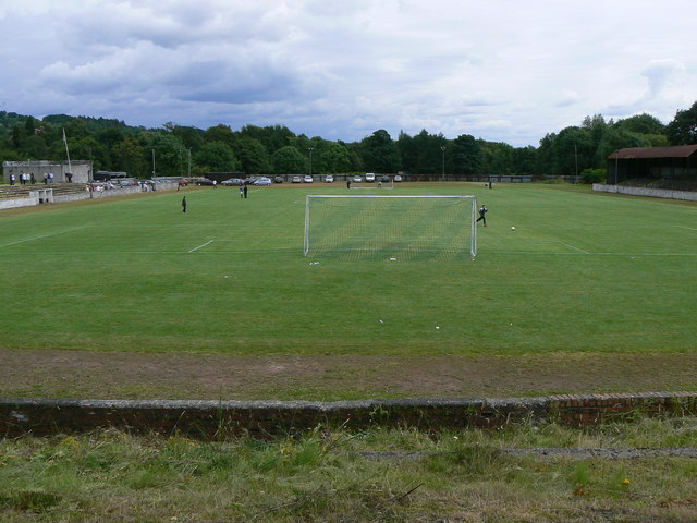
Millburn Park

Millburn Park is a football ground in Alexandria, Scotland. It has been the home ground of Vale of Leven since 1888, hosting Scottish Football League matches...

Alexandria railway station

Alexandria railway station serves the town of Alexandria, Scotland. The station is managed by ScotRail and is served by their trains on the North Clyde...

Nearby Amenities

Located within 500m of 55.981771,-4.5603822
Power: pole
Lat/Long: 55.9811706/-4.552413
Power: pole
Lat/Long: 55.9799299/-4.5538208
Post Office
Ladyton Post Office
Addr Postcode: G83 9DZ
Brand: Post Office
Brand Wikidata: Q1783168
Ref Pol Id: 2310
Source: OS_OpenData_StreetView
Lat/Long: 55.9794344/-4.5638208
School: entrance
Lat/Long: 55.9777619/-4.5625263
Crossing: unmarked
Lat/Long: 55.9793453/-4.5632297
Crossing: unmarked
Lat/Long: 55.9796028/-4.5648905
The Split
Description: The road runs between Pappert and Breahead hence 'the Split',
Lat/Long: 55.9795181/-4.5589628
Pappert
Place: neighbourhood
Lat/Long: 55.9811005/-4.559715
O'Hare
Place: neighbourhood
Lat/Long: 55.9812584/-4.5646354
Ladyton
Place: neighbourhood
Lat/Long: 55.9796337/-4.5663617
Power: pole
Lat/Long: 55.980541/-4.5531274
Power: pole
Lat/Long: 55.9792759/-4.5538793
Power: pole
Lat/Long: 55.9850586/-4.5562346
Power: pole
Lat/Long: 55.9841798/-4.5564605
Power: pole
Lat/Long: 55.9831067/-4.5567136
Power: pole
Lat/Long: 55.9820021/-4.5562241
Power: pole
Lat/Long: 55.9808377/-4.5557012
Power: pole
Lat/Long: 55.9799354/-4.5553373
Power: pole
Lat/Long: 55.9788681/-4.5548499
Bus Stop
Bus: yes
Naptan AtcoCode: 6080374
Naptan NaptanCode: 93823728
Public Transport: platform
Lat/Long: 55.9789947/-4.560111
Traffic Calming: cushion
Lat/Long: 55.9785591/-4.5600326
Bus Stop
Bus: yes
Naptan AtcoCode: 6080375
Naptan NaptanCode: 93823795
Public Transport: platform
Lat/Long: 55.978387/-4.5601018
Traffic Calming: cushion
Lat/Long: 55.9775919/-4.5597419
Traffic Calming: cushion
Lat/Long: 55.9779548/-4.5598196
Bus Stop
Bus: yes
Public Transport: platform
Lat/Long: 55.9783419/-4.5558173
Generator Method: photovoltaic
Generator Output Electricity: yes
Generator Source: solar
Generator Type: solar_photovoltaic_panel
Power: generator
Lat/Long: 55.9776599/-4.5587548
Give Way
Direction: backward
Lat/Long: 55.9799696/-4.5573927
Give Way
Direction: backward
Lat/Long: 55.9826659/-4.5602785
The data included in this document is from www.openstreetmap.org. The data is made available under ODbL.

Have you been to Pappert?

Leave your review of Pappert below (or comments, questions and feedback).