Orphir

Settlement in Orkney

Scotland

Orphir

Junction on A964 near Orphir, Orkney
Junction on A964 near Orphir, Orkney Credit: Alpin Stewart

Orphir is a small rural village situated in the Orkney Islands, located in the northern part of Scotland. It is nestled on the western coast of the Mainland, the largest island in the Orkney archipelago. The village is positioned around 10 miles southwest of Kirkwall, the capital of Orkney.

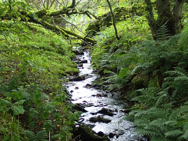
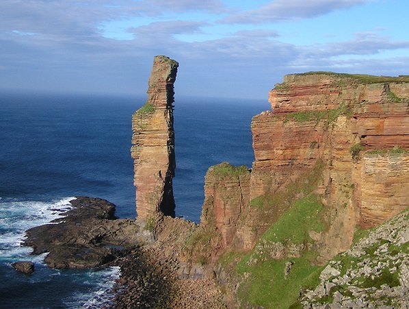
Orphir is known for its stunning natural beauty and rich historical heritage. The landscape in and around the village is characterized by rolling hills, rugged coastlines, and picturesque views of the surrounding islands. The area is home to a diverse range of flora and fauna, making it a haven for nature enthusiasts.

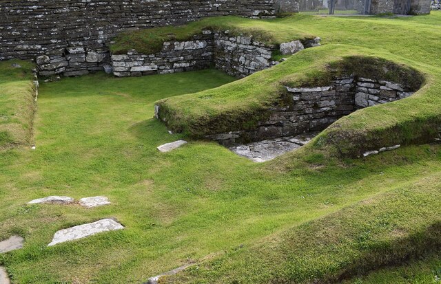
Historically, Orphir was an important center during the Viking Age and is believed to have been a significant seat of power at one time. The remains of the 12th-century Orphir Round Kirk, a circular church, stand as a testament to the village's past. This unique structure is a popular tourist attraction, showcasing the architectural expertise of the era.

Today, Orphir offers a peaceful and tranquil setting for residents and visitors alike. It is a popular destination for outdoor activities such as hiking, birdwatching, and fishing. The village also hosts various cultural events and festivals throughout the year, providing an opportunity to experience the local traditions and community spirit.

In terms of amenities, Orphir has a small primary school, a community hall, and a few local businesses. However, for a wider range of services, residents often travel to nearby towns such as Kirkwall or Stromness.

Overall, Orphir is a charming village that offers a unique blend of natural beauty and historical significance, making it a must-visit destination for anyone exploring the Orkney Islands.

If you have any feedback on the listing, please let us know in the comments section below.

Orphir Images

Images are sourced within 2km of 58.934972/-3.1432268 or Grid Reference HY3405. Thanks to Geograph Open Source API. All images are credited.

Junction on A964 near Orphir, Orkney
A964 at Orphir, Orkney
Leaving Orphir on A964 eastbound
Ruined croft east of Swanbister
Rough pasture with farmland beyond
Scapa Flow Lodges Self-catering accommodation overlooking Scapa Flow
Scapa Flow Lodges
Self-catering accommodation overlooking Scapa Flow
Ruined buildings near Crya
Orphir - Earl's Bu - Foundations of Drinking Hall It is thought that these earthworks and stones are the foundations of an ancient 'Drinking Hall' known as Earl's Bu.
If this is correct, then in 1136 they witnessed the murder of Svenn Brestrope.
During Earl Paul's Yule feasts at his Bu there was an exchange of insults between Sweyn Asleifsson and Sweyn Breastrope (Svenn Brestrope), a colleague of Asleifsson's father. This culminated in the hot-headed young Asleifsson killing Brestrope.
The murderer fled to Egilsay and from thence was dispatched to Tiree by Bishop William the Old. He was given refuge there by a chieftain by the name of Holbodi. Somewhat later young Asleifsson returned to Orkney and managed to kidnap Earl Paul on the island of Rousay, "spiriting him away and leaving the Earldom open for Rognvald II to step in and assume control."
According to other references in the Orkneyinga Saga, Earl Haraldr died at Orphir in 1127 and the Bu (or hall) subsequently belonged to Earl Paul II (1136-7) and Earl Rognvaldr II (1154) who commissioned <a href="https://www.geograph.org.uk/photo/7549699">HY4410 : Kirkwall - St Magnus Cathedral from the Bishop's Palace</a>. Earl Haraldr Maddadson was said to be in hiding at the Bu of Orphir in 1154. (Information from nearby HES plaque and from an adapted translation of the Orkneyinga Saga online).
See Canmore website: <span class="nowrap"><a title="https://canmore.org.uk/site/1970/orphir-earls-bu" rel="nofollow ugc noopener" href="https://canmore.org.uk/site/1970/orphir-earls-bu">Link</a><img style="margin-left:2px;" alt="External link" title="External link - shift click to open in new window" src="https://s1.geograph.org.uk/img/external.png" width="10" height="10"/></span>
HES Website: <span class="nowrap"><a title="https://www.historicenvironment.scot/visit-a-place/places/earls-bu-and-church-orphir" rel="nofollow ugc noopener" href="https://www.historicenvironment.scot/visit-a-place/places/earls-bu-and-church-orphir">Link</a><img style="margin-left:2px;" alt="External link" title="External link - shift click to open in new window" src="https://s1.geograph.org.uk/img/external.png" width="10" height="10"/></span>
See also <a href="https://www.geograph.org.uk/photo/7560896">HY3304 : Orphir - Earl's Bu - Stones and recesses</a>
This site is adjacent to <a href="https://www.geograph.org.uk/photo/7560899">HY3304 : Orphir - St Nicholas Round Kirk (remains)</a>
Orphir - Earl's Bu - Foundations of Drinking Hall
It is thought that these earthworks and stones are the foundations of an ancient 'Drinking Hall' known as Earl's Bu. If this is correct, then in 1136 they witnessed the murder of Svenn Brestrope. During Earl Paul's Yule feasts at his Bu there was an exchange of insults between Sweyn Asleifsson and Sweyn Breastrope (Svenn Brestrope), a colleague of Asleifsson's father. This culminated in the hot-headed young Asleifsson killing Brestrope. The murderer fled to Egilsay and from thence was dispatched to Tiree by Bishop William the Old. He was given refuge there by a chieftain by the name of Holbodi. Somewhat later young Asleifsson returned to Orkney and managed to kidnap Earl Paul on the island of Rousay, "spiriting him away and leaving the Earldom open for Rognvald II to step in and assume control." According to other references in the Orkneyinga Saga, Earl Haraldr died at Orphir in 1127 and the Bu (or hall) subsequently belonged to Earl Paul II (1136-7) and Earl Rognvaldr II (1154) who commissioned HY4410 : Kirkwall - St Magnus Cathedral from the Bishop's Palace. Earl Haraldr Maddadson was said to be in hiding at the Bu of Orphir in 1154. (Information from nearby HES plaque and from an adapted translation of the Orkneyinga Saga online). See Canmore website: LinkExternal link HES Website: LinkExternal link See also HY3304 : Orphir - Earl's Bu - Stones and recesses This site is adjacent to HY3304 : Orphir - St Nicholas Round Kirk (remains)
Orphir - Earl's Bu - Stones and recesses Part of the foundations of the C12th Earl's Bu at Orphir on Mainland, Orkney.
See <a href="https://www.geograph.org.uk/photo/7560879">HY3304 : Orphir - Earl's Bu - Foundations of Drinking Hall</a> for more information on the history of this former Drinking Hall.
This site is adjacent to <a href="https://www.geograph.org.uk/photo/7560899">HY3304 : Orphir - St Nicholas Round Kirk (remains)</a>
See Canmore website for information on the site: <span class="nowrap"><a title="https://canmore.org.uk/site/1970/orphir-earls-bu" rel="nofollow ugc noopener" href="https://canmore.org.uk/site/1970/orphir-earls-bu">Link</a><img style="margin-left:2px;" alt="External link" title="External link - shift click to open in new window" src="https://s1.geograph.org.uk/img/external.png" width="10" height="10"/></span>
HES Website: <span class="nowrap"><a title="https://www.historicenvironment.scot/visit-a-place/places/earls-bu-and-church-orphir" rel="nofollow ugc noopener" href="https://www.historicenvironment.scot/visit-a-place/places/earls-bu-and-church-orphir">Link</a><img style="margin-left:2px;" alt="External link" title="External link - shift click to open in new window" src="https://s1.geograph.org.uk/img/external.png" width="10" height="10"/></span>
Orphir - Earl's Bu - Stones and recesses
Part of the foundations of the C12th Earl's Bu at Orphir on Mainland, Orkney. See HY3304 : Orphir - Earl's Bu - Foundations of Drinking Hall for more information on the history of this former Drinking Hall. This site is adjacent to HY3304 : Orphir - St Nicholas Round Kirk (remains) See Canmore website for information on the site: LinkExternal link HES Website: LinkExternal link
Orphir - St Nicholas Round Kirk (remains) The apsidal eastern remains of the former round kirk of St Nicholas at Orphir.
The ring of gravel marks its original footprint.
From the Canmore website: "The remains of a Romanesque Church, dedicated to St Nicholas, which has been circular on plan with an E apse, stands at the E end of the now demolished parish church. It is unique in Scotland as having been built after the model of the Church of the Holy Sepulchre in Jerusalem, through Scandinavian prototypes, and it can be dated between AD 1090 and 1160. A reference under the year 1136 in the 'Orkneyinga Saga', mentions this church, although Wainwright argues that the writer may have been describing the church as he knew it about a century later. Wainwright would also place the erection of the church after 1100 on comparison with three, very similar, churches at Praha (Prague)."
See also <a href="https://www.geograph.org.uk/photo/7560901">HY3304 : Orphir - St Nicholas Round Kirk apse from northeast</a>
The church is adjacent to <a href="https://www.geograph.org.uk/photo/7560879">HY3304 : Orphir - Earl's Bu - Foundations of Drinking Hall</a>
HES Website: <span class="nowrap"><a title="https://www.historicenvironment.scot/visit-a-place/places/earls-bu-and-church-orphir" rel="nofollow ugc noopener" href="https://www.historicenvironment.scot/visit-a-place/places/earls-bu-and-church-orphir">Link</a><img style="margin-left:2px;" alt="External link" title="External link - shift click to open in new window" src="https://s1.geograph.org.uk/img/external.png" width="10" height="10"/></span>
Canmore website: <span class="nowrap"><a title="https://canmore.org.uk/site/1962/orphir-st-nicholass-church" rel="nofollow ugc noopener" href="https://canmore.org.uk/site/1962/orphir-st-nicholass-church">Link</a><img style="margin-left:2px;" alt="External link" title="External link - shift click to open in new window" src="https://s1.geograph.org.uk/img/external.png" width="10" height="10"/></span>
Orphir - St Nicholas Round Kirk (remains)
The apsidal eastern remains of the former round kirk of St Nicholas at Orphir. The ring of gravel marks its original footprint. From the Canmore website: "The remains of a Romanesque Church, dedicated to St Nicholas, which has been circular on plan with an E apse, stands at the E end of the now demolished parish church. It is unique in Scotland as having been built after the model of the Church of the Holy Sepulchre in Jerusalem, through Scandinavian prototypes, and it can be dated between AD 1090 and 1160. A reference under the year 1136 in the 'Orkneyinga Saga', mentions this church, although Wainwright argues that the writer may have been describing the church as he knew it about a century later. Wainwright would also place the erection of the church after 1100 on comparison with three, very similar, churches at Praha (Prague)." See also HY3304 : Orphir - St Nicholas Round Kirk apse from northeast The church is adjacent to HY3304 : Orphir - Earl's Bu - Foundations of Drinking Hall HES Website: LinkExternal link Canmore website: LinkExternal link
Orphir - St Nicholas Round Kirk apse from northeast From this angle the remains of the apse of the former circular kirk at Orphir looks more like a dovecote or perhaps the base of a windmill. To see how it attached to the original church, see <a href="https://www.geograph.org.uk/photo/7560899">HY3304 : Orphir - St Nicholas Round Kirk (remains)</a>
See also 
HES website: <span class="nowrap"><a title="https://www.historicenvironment.scot/visit-a-place/places/earls-bu-and-church-orphir" rel="nofollow ugc noopener" href="https://www.historicenvironment.scot/visit-a-place/places/earls-bu-and-church-orphir">Link</a><img style="margin-left:2px;" alt="External link" title="External link - shift click to open in new window" src="https://s1.geograph.org.uk/img/external.png" width="10" height="10"/></span>
Canmore website: <span class="nowrap"><a title="https://canmore.org.uk/site/1962/orphir-st-nicholass-church" rel="nofollow ugc noopener" href="https://canmore.org.uk/site/1962/orphir-st-nicholass-church">Link</a><img style="margin-left:2px;" alt="External link" title="External link - shift click to open in new window" src="https://s1.geograph.org.uk/img/external.png" width="10" height="10"/></span>
These remains are adjacent to <a href="https://www.geograph.org.uk/photo/7560879">HY3304 : Orphir - Earl's Bu - Foundations of Drinking Hall</a>
Orphir - St Nicholas Round Kirk apse from northeast
From this angle the remains of the apse of the former circular kirk at Orphir looks more like a dovecote or perhaps the base of a windmill. To see how it attached to the original church, see HY3304 : Orphir - St Nicholas Round Kirk (remains) See also HES website: LinkExternal link Canmore website: LinkExternal link These remains are adjacent to HY3304 : Orphir - Earl's Bu - Foundations of Drinking Hall
Gyre Woods Orphir Inside Gyre woodland. Passive management, mixed deciduous woodland with a fairly healthy streamway.
Gyre Woods Orphir
Inside Gyre woodland. Passive management, mixed deciduous woodland with a fairly healthy streamway.
The road beside Gyre Wood The road to the Breck. Rare in Orkney to have overhanging trees, but the Trows need these to get across roadways.
The road beside Gyre Wood
The road to the Breck. Rare in Orkney to have overhanging trees, but the Trows need these to get across roadways.
The invitation Permissive access to private woodland; passively managed with short easy-going (but muddy) pathways. A picnic table, a clean stream-way with plenty of bryophytes, fungi and brambles. Wych elm, rowan and sycamore with an unusual patch of big Butterbur (Petasites hybridus)
The invitation
Permissive access to private woodland; passively managed with short easy-going (but muddy) pathways. A picnic table, a clean stream-way with plenty of bryophytes, fungi and brambles. Wych elm, rowan and sycamore with an unusual patch of big Butterbur (Petasites hybridus)
Sycamore tree Inside Gyre wood, many trees show their age and some show signs of long-ago coppicing. Some successful under-planting has taken place; the wood is being managed sensitively and fairly passively. Woodland is rare in Orkney.
Sycamore tree
Inside Gyre wood, many trees show their age and some show signs of long-ago coppicing. Some successful under-planting has taken place; the wood is being managed sensitively and fairly passively. Woodland is rare in Orkney.
Butterbur forest Inside the woodland is a huge seasonal 'stand' of Butterbur (Petasites hybridus). This very large-leaved and tall plant hosts a great number of invertebrates and shelters specialised fungi. It is potentially sensitive, so trampling should not be encouraged.
Recently the most northerly record of a specific and rare but very TINY beetle, was located here. See <span class="nowrap"><a title="http://www.ispotnature.org/node/728377" rel="nofollow ugc noopener" href="http://www.ispotnature.org/node/728377">Link</a><img style="margin-left:2px;" alt="External link" title="External link - shift click to open in new window" src="https://s1.geograph.org.uk/img/external.png" width="10" height="10"/></span>
Butterbur forest
Inside the woodland is a huge seasonal 'stand' of Butterbur (Petasites hybridus). This very large-leaved and tall plant hosts a great number of invertebrates and shelters specialised fungi. It is potentially sensitive, so trampling should not be encouraged. Recently the most northerly record of a specific and rare but very TINY beetle, was located here. See LinkExternal link
Orkneyinga Saga Centre in Orphir This heritage Centre is close to the Orphir walk and the historical remains of St. Nicholas's Church.
Orkneyinga Saga Centre in Orphir
This heritage Centre is close to the Orphir walk and the historical remains of St. Nicholas's Church.
Orphir Kirk and Gyre Road Viewed from the A964
Orphir Kirk and Gyre Road
Viewed from the A964
Show me another place!

Orphir is located at Grid Ref: HY3405 (Lat: 58.934972, Lng: -3.1432268)

Unitary Authority: Orkney Islands

Police Authority: Highlands and Islands

What 3 Words

///tower.topples.revamped. Near Orphir, Orkney Islands

Nearby Locations

Swanbister Orphir

Related Wikis

Orphir

Orphir (pronounced , Old Norse: Jorfjara/Orfjara) is a parish and settlement on Mainland, Orkney, Scotland. It is approximately 9 miles (14 kilometres...
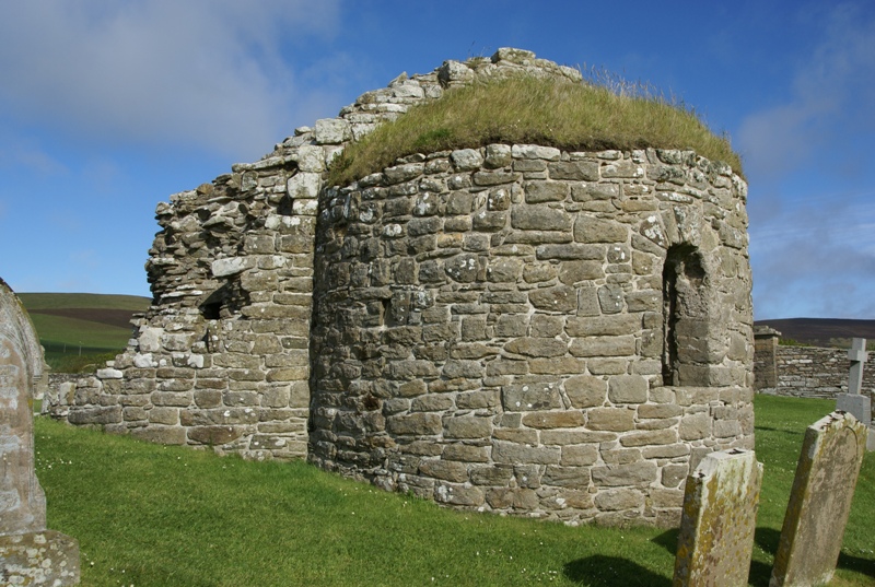
Orphir Round Church

The remains of the Orphir Round Church (or Round Kirk), also St Nicholas's Church, are located in Orphir Parish on the Mainland, Orkney, Scotland. It has...
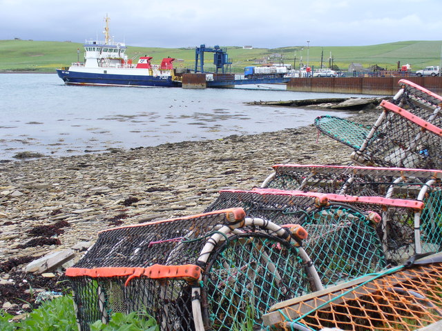
Houton

Houton is a settlement 5 miles (8.0 km) southeast of Stromness on the island of Mainland, Orkney, Scotland. The settlement is within the parish of Orphir...

Hoy and West Mainland National Scenic Area

Hoy and West Mainland is a national scenic area (NSA) covering parts of the islands of Hoy and Mainland in the Orkney Islands of Scotland, as well as...

Nearby Amenities

Located within 500m of 58.934972,-3.1432268
Bus Stop
Shelter: yes
Lat/Long: 58.936008/-3.1423979
Historic: memorial
Lat/Long: 58.9359001/-3.1427466
Orphir
Alt Name Non: Orfjara
Name En: Orphir
Name Non: Jorfjara
Place: village
Wikidata: Q2031524
Wikipedia: en:Orphir
Lat/Long: 58.9362373/-3.1450715
Telephone
Booth: KX100
Covered: booth
Lat/Long: 58.9362956/-3.1411377
Post Box
Post Box Type: lamp
Ref: KW17 34
Royal Cypher: scottish_crown
Lat/Long: 58.9362804/-3.1411699
Generator Method: wind_turbine
Generator Source: wind
Power: generator
Lat/Long: 58.9375638/-3.1445863
Bar
The Noust
Lat/Long: 58.9346811/-3.1440654
Power: pole
Lat/Long: 58.933658/-3.1502381
Power: pole
Lat/Long: 58.9336218/-3.1489574
Power: pole
Lat/Long: 58.9335911/-3.1476768
Power: pole
Lat/Long: 58.9335603/-3.1464894
Power: pole
Lat/Long: 58.9335269/-3.1451543
Power: pole
Lat/Long: 58.9334894/-3.143687
Power: pole
Lat/Long: 58.9335148/-3.1434874
Power: pole
Lat/Long: 58.9336646/-3.1424141
Power: pole
Lat/Long: 58.9338292/-3.1413564
Power: pole
Lat/Long: 58.9340125/-3.140138
Power: pole
Lat/Long: 58.9344472/-3.1390206
Power: pole
Lat/Long: 58.9347603/-3.1382559
Power: pole
Lat/Long: 58.935096/-3.137403
Power: pole
Lat/Long: 58.9354371/-3.1365552
Power: pole
Lat/Long: 58.935664/-3.1352987
Power: pole
Lat/Long: 58.9365274/-3.1400265
Power: pole
Lat/Long: 58.9354091/-3.1400965
Power: pole
Lat/Long: 58.9346934/-3.1401146
Power: pole
Lat/Long: 58.9333529/-3.1401354
Power: pole
Lat/Long: 58.9327001/-3.1401665
Power: pole
Lat/Long: 58.932462/-3.139031
Power: pole
Lat/Long: 58.9322626/-3.1380433
Power: pole
Lat/Long: 58.9320486/-3.1370296
Power: pole
Lat/Long: 58.9339255/-3.1478006
Power: pole
Lat/Long: 58.9345409/-3.1480209
Power: pole
Lat/Long: 58.9348011/-3.1481726
Power: pole
Lat/Long: 58.9352933/-3.1484642
Power: pole
Lat/Long: 58.936108/-3.1489568
Power: pole
Lat/Long: 58.9369534/-3.1494597
Power: pole
Lat/Long: 58.937649/-3.1498615
Power: pole
Lat/Long: 58.9349736/-3.1472406
Power: pole
Lat/Long: 58.9351315/-3.146481
Power: pole
Lat/Long: 58.9352826/-3.145724
Power: pole
Lat/Long: 58.9354244/-3.1450267
Power: pole
Lat/Long: 58.9356726/-3.1438082
Power: pole
Lat/Long: 58.9358217/-3.1431212
Man Made: mast
Tower Type: communication
Lat/Long: 58.9347231/-3.1433575
Defibrillator
Defibrillator Location: Orphir Community School. Left hand side of external wall facing carpark.
Emergency: defibrillator
Indoor: no
Lat/Long: 58.9362058/-3.1415501
The data included in this document is from www.openstreetmap.org. The data is made available under ODbL.

Have you been to Orphir?

Leave your review of Orphir below (or comments, questions and feedback).