Lurglomand

Settlement in Perthshire

Scotland

Lurglomand

Entering Acharn
Entering Acharn Credit: N Chadwick

Lurglomand is a picturesque village located in the county of Perthshire, Scotland. Situated amidst the stunning natural beauty of the Scottish Highlands, this charming settlement is nestled between rolling hills and lush greenery, creating a serene and idyllic atmosphere.

The village itself is small, with a population of around 500 residents, lending to its tight-knit community feel. Lurglomand is renowned for its traditional Scottish architecture, with quaint stone cottages lining the streets, adorned with colorful flower gardens. Its well-preserved historic buildings showcase the village's rich heritage, providing visitors with a glimpse into its past.

The surrounding area of Lurglomand is a haven for outdoor enthusiasts, offering a plethora of activities. The nearby Loch Lurglomand is a popular spot for fishing, boating, and hiking, while the surrounding hills provide exceptional opportunities for hillwalking and wildlife spotting. The village is also a gateway to the famous Grampian Mountains, attracting climbers and mountaineers from around the world.

Lurglomand is not only known for its natural beauty but also for its warm and welcoming community. The locals take great pride in their village, organizing various events and festivals throughout the year, such as the Highland Games and traditional music gatherings. The village also boasts a few charming local shops, cafes, and pubs, where visitors can indulge in the delights of Scottish cuisine and hospitality.

Overall, Lurglomand is a hidden gem in the heart of Perthshire, offering a tranquil escape from the bustle of city life, coupled with breathtaking landscapes and a strong sense of community spirit.

If you have any feedback on the listing, please let us know in the comments section below.
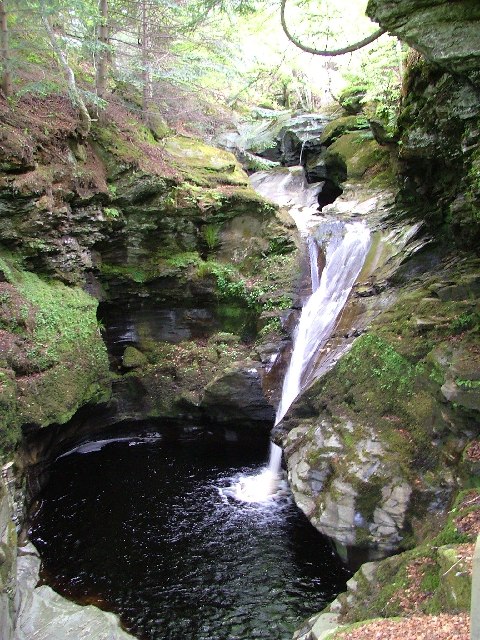
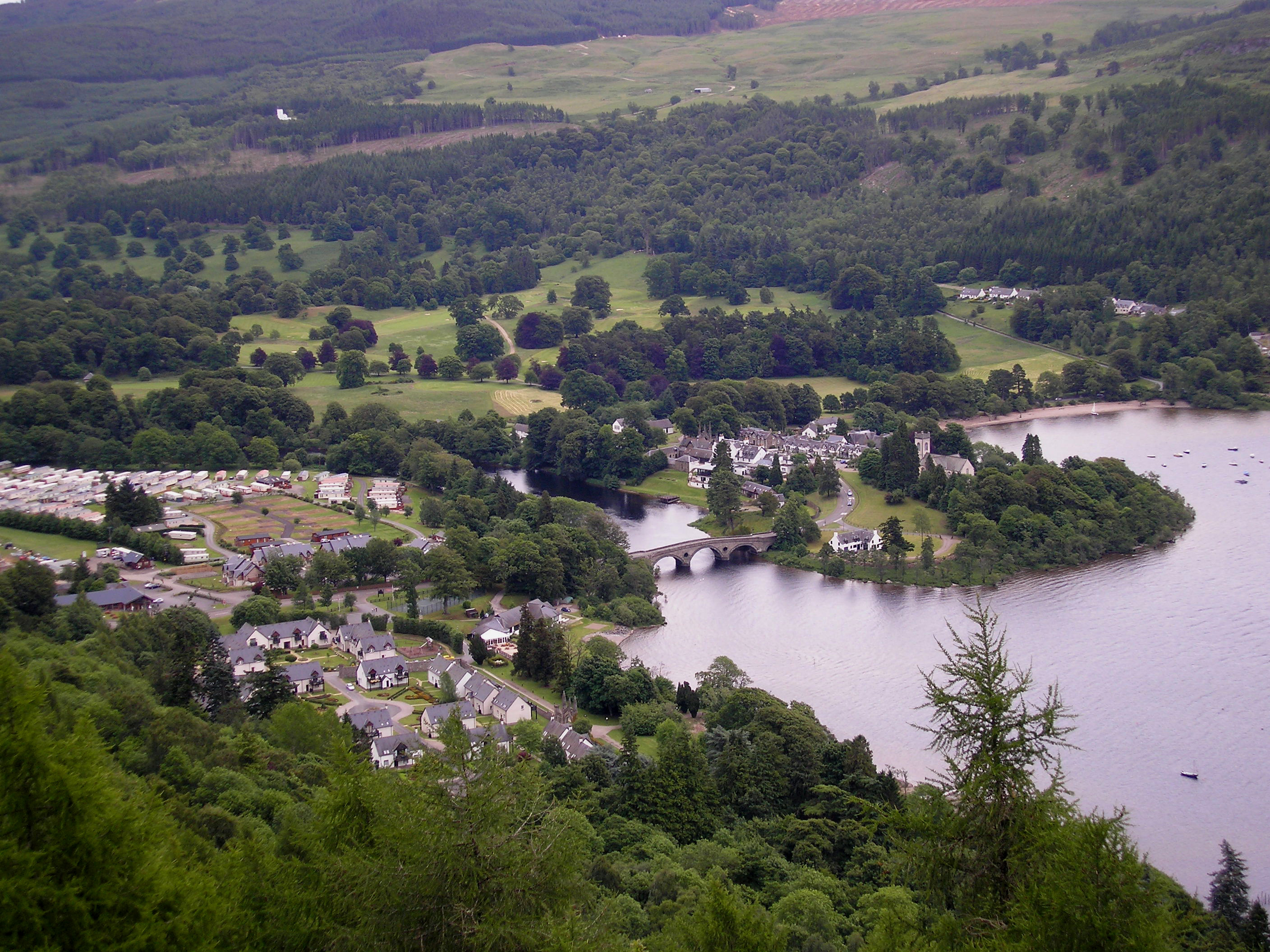
Lurglomand Images

Images are sourced within 2km of 56.565199/-4.0404897 or Grid Reference NN7443. Thanks to Geograph Open Source API. All images are credited.

Entering Acharn
Entering Acharn
Acharn
Acharn
A827, Letterellen The A827 is a cross-country route through the glens of central Scotland, running 35 miles along the entire length of Loch Tay, from Lix Toll to Ballinluig. 
<span class="nowrap"><a title="https://www.sabre-roads.org.uk/wiki/index.php?title=A827" rel="nofollow ugc noopener" href="https://www.sabre-roads.org.uk/wiki/index.php?title=A827">Link</a><img style="margin-left:2px;" alt="External link" title="External link - shift click to open in new window" src="https://s1.geograph.org.uk/img/external.png" width="10" height="10"/></span>
A827, Letterellen
The A827 is a cross-country route through the glens of central Scotland, running 35 miles along the entire length of Loch Tay, from Lix Toll to Ballinluig. LinkExternal link
A827, Tay Forest Park The A827 is a cross-country route through the glens of central Scotland, running 35 miles along the entire length of Loch Tay, from Lix Toll to Ballinluig. 
<span class="nowrap"><a title="https://www.sabre-roads.org.uk/wiki/index.php?title=A827" rel="nofollow ugc noopener" href="https://www.sabre-roads.org.uk/wiki/index.php?title=A827">Link</a><img style="margin-left:2px;" alt="External link" title="External link - shift click to open in new window" src="https://s1.geograph.org.uk/img/external.png" width="10" height="10"/></span>
A827, Tay Forest Park
The A827 is a cross-country route through the glens of central Scotland, running 35 miles along the entire length of Loch Tay, from Lix Toll to Ballinluig. LinkExternal link
A827 The A827 is a cross-country route through the glens of central Scotland, running 35 miles along the entire length of Loch Tay, from Lix Toll to Ballinluig. 
<span class="nowrap"><a title="https://www.sabre-roads.org.uk/wiki/index.php?title=A827" rel="nofollow ugc noopener" href="https://www.sabre-roads.org.uk/wiki/index.php?title=A827">Link</a><img style="margin-left:2px;" alt="External link" title="External link - shift click to open in new window" src="https://s1.geograph.org.uk/img/external.png" width="10" height="10"/></span>
A827
The A827 is a cross-country route through the glens of central Scotland, running 35 miles along the entire length of Loch Tay, from Lix Toll to Ballinluig. LinkExternal link
Forestry road, Drummond Hill
A827 towards Kenmore
Trees, Upper Acharn
Trees, Upper Acharn
Queen's Drive
Queen's Drive
B&B at Acharn A colourful display at this cottage offering B&B accommodation. The Rob Roy Way turns right past the bend sign, to climb to the Falls of Acharn.
B&B at Acharn
A colourful display at this cottage offering B&B accommodation. The Rob Roy Way turns right past the bend sign, to climb to the Falls of Acharn.
Track to the falls, Acharn The track by the Acharn Burn is also the section of the Rob Roy Way to Aberfeldy.
Track to the falls, Acharn
The track by the Acharn Burn is also the section of the Rob Roy Way to Aberfeldy.
View from the grotto, Falls of Acharn The man-made 'cave' is a folly built by John Campbell, 3rd Earl of Breadalbane in the 1760s. A short dark passage leads to this balcony giving a fine view of the falls. (Source: Rob Roy Way guide, Jacquetta Megarry, Rucksack Readers)
View from the grotto, Falls of Acharn
The man-made 'cave' is a folly built by John Campbell, 3rd Earl of Breadalbane in the 1760s. A short dark passage leads to this balcony giving a fine view of the falls. (Source: Rob Roy Way guide, Jacquetta Megarry, Rucksack Readers)
Falls of Acharn A little mist adding to the impression of the falls, seen from the viewpoint at the grotto or 'Hermit's Cave', an 18th century folly.
Falls of Acharn
A little mist adding to the impression of the falls, seen from the viewpoint at the grotto or 'Hermit's Cave', an 18th century folly.
Grotto at the Falls of Acharn The 'Hermit's Cave' folly built by the 3rd Earl of Breadalbane in the late 18th century, as a picturesque entrance to the viewpoint.
Grotto at the Falls of Acharn
The 'Hermit's Cave' folly built by the 3rd Earl of Breadalbane in the late 18th century, as a picturesque entrance to the viewpoint.
Upper Falls of Acharn The upper part of the series of falls on the Acharn Burn, viewed from the path to a footbridge.
Upper Falls of Acharn
The upper part of the series of falls on the Acharn Burn, viewed from the path to a footbridge.
Upper Falls of Acharn (2) The higher level falls from the boardwalk path to a footbridge.
Upper Falls of Acharn (2)
The higher level falls from the boardwalk path to a footbridge.
Show me another place!

Lurglomand is located at Grid Ref: NN7443 (Lat: 56.565199, Lng: -4.0404897)

Unitary Authority: Perth and Kinross

Police Authority: Tayside

What 3 Words

///item.enchanted.dustbin. Near Aberfeldy, Perth & Kinross

Nearby Locations

Lurglomand

Related Wikis

Acharn, Perth and Kinross

Acharn (Scottish Gaelic: Àth a' Chàirn meaning 'Field of the Cairn[s]') is a hamlet in the Kenmore parish of the Scottish council area of Perth and Kinross...

Falls of Acharn

Falls of Acharn is a waterfall of Scotland. == See also == Acharn Waterfalls of Scotland == References ==

Fearnan

Fearnan (Gaelic Feàrnan, 'Alders') is a small crofting village on the north shore of Loch Tay in Perthshire, Scotland. The village lies at the junction...

Kenmore, Perth and Kinross

Kenmore (Scottish Gaelic: A' Cheannmhor, IPA:[ˈaˈçaun̴̪auvɔɾ]) is a small village in Perthshire, in the Highlands of Scotland, located where Loch Tay drains...

Nearby Amenities

Located within 500m of 56.565199,-4.0404897
Material: wood
Power: pole
Lat/Long: 56.5624881/-4.0462585
Material: wood
Power: pole
Lat/Long: 56.5626011/-4.0452714
Material: wood
Power: pole
Lat/Long: 56.5627171/-4.0442884
Material: wood
Power: pole
Lat/Long: 56.5629632/-4.0432772
Material: wood
Power: pole
Lat/Long: 56.5634303/-4.0425302
Material: wood
Power: pole
Lat/Long: 56.5642195/-4.0412481
Material: wood
Power: pole
Lat/Long: 56.564549/-4.0407076
Material: wood
Power: pole
Lat/Long: 56.5648712/-4.0395892
Material: wood
Power: pole
Lat/Long: 56.5652096/-4.0384492
Material: wood
Power: pole
Lat/Long: 56.5655163/-4.0374193
Material: wood
Power: pole
Lat/Long: 56.5658229/-4.0363236
Material: wood
Power: pole
Lat/Long: 56.5661259/-4.0352762
Material: wood
Power: pole
Lat/Long: 56.5664459/-4.0341564
Material: wood
Power: pole
Lat/Long: 56.5667798/-4.0330057
Power: pole
Lat/Long: 56.5656769/-4.0400087
Power: pole
Lat/Long: 56.5652513/-4.0397408
The data included in this document is from www.openstreetmap.org. The data is made available under ODbL.

Have you been to Lurglomand?

Leave your review of Lurglomand below (or comments, questions and feedback).