Lower Monkhall

Settlement in Shropshire

England

Lower Monkhall

Turn left for Kytes Nest Farm
Turn left for Kytes Nest Farm Credit: Row17

Lower Monkhall is a small village located in the county of Shropshire, England. Situated approximately 6 miles southwest of the town of Shrewsbury, Lower Monkhall is a rural community known for its picturesque surroundings and charming countryside.

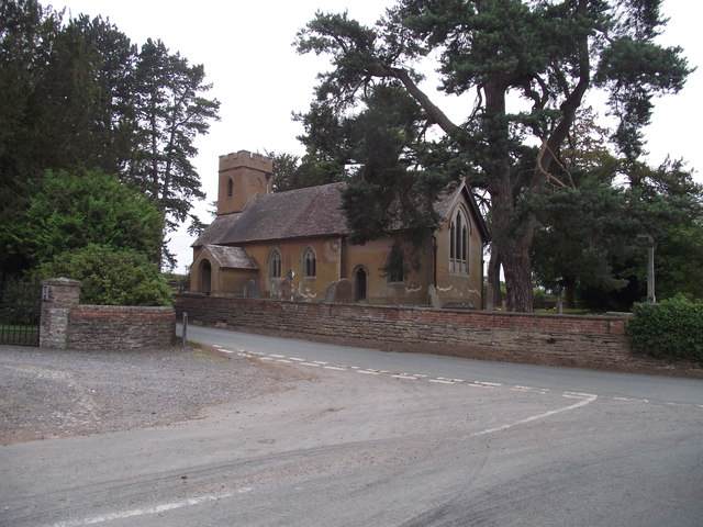
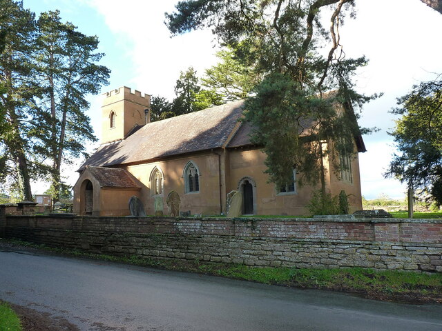
The village is characterized by its traditional English architecture, with many buildings dating back several centuries. The local church, St. Mary's, is a prominent feature of the village, displaying a mix of architectural styles from various eras.

Lower Monkhall is primarily an agricultural community, with farming being the main occupation of its residents. The surrounding countryside is dotted with farmland and fields, providing a peaceful and idyllic backdrop to the village.

Despite its small size, Lower Monkhall boasts a close-knit and friendly community. The village hosts various social events throughout the year, including a summer fĂȘte and a Christmas market, which bring together residents and visitors alike.

The village is also well-positioned for outdoor enthusiasts, with numerous walking and cycling paths in the vicinity. The nearby Shropshire Hills Area of Outstanding Natural Beauty offers stunning landscapes and opportunities for outdoor activities such as hiking, horse riding, and birdwatching.

Overall, Lower Monkhall is a quintessential English village, offering a tranquil and rural lifestyle amidst beautiful countryside, while still being within easy reach of larger towns and amenities.

If you have any feedback on the listing, please let us know in the comments section below.

Lower Monkhall Images

Images are sourced within 2km of 52.544855/-2.5583524 or Grid Reference SO6294. Thanks to Geograph Open Source API. All images are credited.

Turn left for Kytes Nest Farm
Standing strong against the skyline A single tree stands proud in a field of wheat.
Standing strong against the skyline
A single tree stands proud in a field of wheat.
St Peter's Church, Monkhopton Like many others sadly locked.
St Peter's Church, Monkhopton
Like many others sadly locked.
Track to Home Farm, Monkhopton Not recommended for a low sports car.
Track to Home Farm, Monkhopton
Not recommended for a low sports car.
Home Farm Cottages, Monkhopton Double fronted mock Tudor.
Home Farm Cottages, Monkhopton
Double fronted mock Tudor.
Manor House, Acton Round Dating from 1713-14, built for Sir Whitmore Acton, probably to the designs of Francis Smith of Warwick. The pinkish-red brick facade is divided into a 2-3-2 rhythm by giant rusticated pilaster strips. Grade I listed.
-----------------------------------------------------------------------------
In the C18th architectural hierarchy, Smith (1672-1738) lay somewhere between the London elite and the breed of skilled, provincial builder-architects who created substantial parts of the built fabric of the country that we see today. It's likely that brick dust ran in his veins - his father, also Francis, and his brother, William, were bricklayers, his elder brother Richard was also in the trade, and Francis's son, William, inherited his practice. Centred around Warwick, Francis built up a substantial practice, designing numerous country houses for the Midlands gentry, covering every county in the region except Nottinghamshire, as well as churches and the odd public building. After the catastrophic fire of 1694 in Warwick, he and William were contracted to supervise rebuilding and rebuilt parts of the town themselves. Francis assembled a small band of talented craftsmen to whom he returned time and time again. Whilst not particularly innovative, his commissions were secured on the back of building attractive houses to high standards of craftsmanship, his trustworthiness and reliability. Two members of the London elite, James Gibbs and Thomas Archer, entrusted Francis to execute several of their designs, and it seems likely that in at least one of these cases he modified the building to his own designs.
Manor House, Acton Round
Dating from 1713-14, built for Sir Whitmore Acton, probably to the designs of Francis Smith of Warwick. The pinkish-red brick facade is divided into a 2-3-2 rhythm by giant rusticated pilaster strips. Grade I listed. ----------------------------------------------------------------------------- In the C18th architectural hierarchy, Smith (1672-1738) lay somewhere between the London elite and the breed of skilled, provincial builder-architects who created substantial parts of the built fabric of the country that we see today. It's likely that brick dust ran in his veins - his father, also Francis, and his brother, William, were bricklayers, his elder brother Richard was also in the trade, and Francis's son, William, inherited his practice. Centred around Warwick, Francis built up a substantial practice, designing numerous country houses for the Midlands gentry, covering every county in the region except Nottinghamshire, as well as churches and the odd public building. After the catastrophic fire of 1694 in Warwick, he and William were contracted to supervise rebuilding and rebuilt parts of the town themselves. Francis assembled a small band of talented craftsmen to whom he returned time and time again. Whilst not particularly innovative, his commissions were secured on the back of building attractive houses to high standards of craftsmanship, his trustworthiness and reliability. Two members of the London elite, James Gibbs and Thomas Archer, entrusted Francis to execute several of their designs, and it seems likely that in at least one of these cases he modified the building to his own designs.
Acton Round Indian kiosk A modern folly built to disguise a water tank.
Acton Round Indian kiosk
A modern folly built to disguise a water tank.
Woodland above Monkhopton
Monkhopton Looking towards the B4368.
Monkhopton
Looking towards the B4368.
Wheatfields by the B4368 near Weston, Shropshire The B4368 links Craven Arms with Morville, near Bridgnorth. It is a very attractive rural route which tempts drivers into faster speeds than are safe in some places.
Wheatfields by the B4368 near Weston, Shropshire
The B4368 links Craven Arms with Morville, near Bridgnorth. It is a very attractive rural route which tempts drivers into faster speeds than are safe in some places.
Arable land east of Monkhopton, Shropshire Extensive wheat fields are ready for harvest, and work is progressing in many fields in the region. This field is already stubble, awaiting preparation for the next crop.
Arable land east of Monkhopton, Shropshire
Extensive wheat fields are ready for harvest, and work is progressing in many fields in the region. This field is already stubble, awaiting preparation for the next crop.
Farmland north-east of Monkhopton, Shropshire The land is north of Brickyard Farm.
Farmland north-east of Monkhopton, Shropshire
The land is north of Brickyard Farm.
Monkhopton War Memorial Originally erected in 1921, with restoration work carried out in 2000. The base is made from an old cider press stone, whilst the shaft and cross are oak and the memorial is to two local men who died in the first World War. Grade II listed <span class="nowrap"><a title="https://britishlistedbuildings.co.uk/101459122-monkhopton-war-memorial-monkhopton#.YhZymujP3IU" rel="nofollow ugc noopener" href="https://britishlistedbuildings.co.uk/101459122-monkhopton-war-memorial-monkhopton#.YhZymujP3IU">Link</a><img style="margin-left:2px;" alt="External link" title="External link - shift click to open in new window" src="https://s1.geograph.org.uk/img/external.png" width="10" height="10"/></span> & <span class="nowrap"><a title="https://historicengland.org.uk/listing/the-list/list-entry/1459122" rel="nofollow ugc noopener" href="https://historicengland.org.uk/listing/the-list/list-entry/1459122">Link</a><img style="margin-left:2px;" alt="External link" title="External link - shift click to open in new window" src="https://s1.geograph.org.uk/img/external.png" width="10" height="10"/></span> in 2018.
Monkhopton War Memorial
Originally erected in 1921, with restoration work carried out in 2000. The base is made from an old cider press stone, whilst the shaft and cross are oak and the memorial is to two local men who died in the first World War. Grade II listed LinkExternal link & LinkExternal link in 2018.
OS benchmark - Monkhopton church gate An OS cutmark at the base of the gateway into the church yard from the road; last levelled by the OS in 1973 at 130.755m above Ordnance Datum Newlyn.
OS benchmark - Monkhopton church gate
An OS cutmark at the base of the gateway into the church yard from the road; last levelled by the OS in 1973 at 130.755m above Ordnance Datum Newlyn.
St Peter's Church, Monkhopton A rather fine village church, with traces of its original 12th century structure still visible, particularly in some of the window openings. The tower was built in 1835. Grade II* listed <span class="nowrap"><a title="https://britishlistedbuildings.co.uk/101367522-church-of-st-peter-monkhopton#.YhZ3tujP3IU" rel="nofollow ugc noopener" href="https://britishlistedbuildings.co.uk/101367522-church-of-st-peter-monkhopton#.YhZ3tujP3IU">Link</a><img style="margin-left:2px;" alt="External link" title="External link - shift click to open in new window" src="https://s1.geograph.org.uk/img/external.png" width="10" height="10"/></span> & <span class="nowrap"><a title="https://historicengland.org.uk/listing/the-list/list-entry/1367522" rel="nofollow ugc noopener" href="https://historicengland.org.uk/listing/the-list/list-entry/1367522">Link</a><img style="margin-left:2px;" alt="External link" title="External link - shift click to open in new window" src="https://s1.geograph.org.uk/img/external.png" width="10" height="10"/></span> in 1970.
St Peter's Church, Monkhopton
A rather fine village church, with traces of its original 12th century structure still visible, particularly in some of the window openings. The tower was built in 1835. Grade II* listed LinkExternal link & LinkExternal link in 1970.
OS benchmark - Monkhopton, roadside building Located on an outhouse beside the Old Schoolhouse just outside the village, and rather obscured by vegetation. This mark was last levelled by the OS in 1973 at 143.507m above Ordnance Datum Newlyn.
OS benchmark - Monkhopton, roadside building
Located on an outhouse beside the Old Schoolhouse just outside the village, and rather obscured by vegetation. This mark was last levelled by the OS in 1973 at 143.507m above Ordnance Datum Newlyn.
Woodland edge on the road above Monkhopton
Show me another place!

Lower Monkhall is located at Grid Ref: SO6294 (Lat: 52.544855, Lng: -2.5583524)

Unitary Authority: Shropshire

Police Authority: West Merica

What 3 Words

///comically.plant.toxic. Near Much Wenlock, Shropshire

Related Wikis

Monkhopton

Monkhopton is a village and civil parish in Shropshire, England. It is 6.5 miles south of Much Wenlock. There is an Anglican church: Its co-ordinates are...

Acton Round

Acton Round is a village and civil parish in the English county of Shropshire. Acton Round was recorded in the Domesday Book as Achetune. The civil parish...

Aston Eyre Hall

Aston Eyre Hall is an unfortified stone manor house at Aston Eyre near Bridgnorth in the English county of Shropshire, United Kingdom. It is a Grade II...

Aston Eyre

Aston Eyre is a hamlet and civil parish in Shropshire, England, about four miles west of Bridgnorth. The area has a significant amount of green space....

Nearby Amenities

Located within 500m of 52.544855,-2.5583524
Addr City: Bridgnorth
Addr Housename: Lower Monkhall Cottage
Addr Housenumber: 73
Building: house
Lat/Long: 52.5444947/-2.5596977
Man Made: fishing_peg
Lat/Long: 52.5442402/-2.5537628
Man Made: fishing_peg
Lat/Long: 52.5443304/-2.5538155
Man Made: fishing_peg
Lat/Long: 52.5444643/-2.5538146
Man Made: fishing_peg
Lat/Long: 52.5445493/-2.5536669
Man Made: fishing_peg
Lat/Long: 52.5445709/-2.5535183
Man Made: fishing_peg
Lat/Long: 52.54459/-2.5533577
Man Made: fishing_peg
Lat/Long: 52.5445315/-2.5531277
Man Made: fishing_peg
Lat/Long: 52.5444153/-2.5530586
Man Made: fishing_peg
Lat/Long: 52.5442865/-2.5531578
Man Made: fishing_peg
Lat/Long: 52.5442261/-2.5532987
Man Made: fishing_peg
Lat/Long: 52.5441629/-2.5534576
The data included in this document is from www.openstreetmap.org. The data is made available under ODbL.

Have you been to Lower Monkhall?

Leave your review of Lower Monkhall below (or comments, questions and feedback).