Lochanhead

Settlement in Kirkcudbrightshire

Scotland

Lochanhead

A Chain on a Gravestone An unusual gravestone with a chain attached, in Lochrutton kirkyard.
This photo was taken on the 10th.Sept.2022.
A Chain on a Gravestone Credit: Rab McMurdo

The requested URL returned error: 429 Too Many Requests

If you have any feedback on the listing, please let us know in the comments section below.

Lochanhead Images

Images are sourced within 2km of 55.027057/-3.706962 or Grid Reference NX9071. Thanks to Geograph Open Source API. All images are credited.

A Chain on a Gravestone An unusual gravestone with a chain attached, in Lochrutton kirkyard.
This photo was taken on the 10th.Sept.2022.
A Chain on a Gravestone
An unusual gravestone with a chain attached, in Lochrutton kirkyard. This photo was taken on the 10th.Sept.2022.
Lochrutton Loch Looking towards the water control facility on Lochrutton Loch, viewed from the edge of the square.
Lochrutton Loch
Looking towards the water control facility on Lochrutton Loch, viewed from the edge of the square.
Lochrutton Structure Control tower for regulating the taking of water from Lochrutton.
Lochrutton Structure
Control tower for regulating the taking of water from Lochrutton.
Blue skies
Blue skies
Crannog in Lochrutton Loch The trees on the little island mark the position of a crannog (a small man-made island) typical of many found in Scottish inland lochs.
Crannog in Lochrutton Loch
The trees on the little island mark the position of a crannog (a small man-made island) typical of many found in Scottish inland lochs.
Lochrutton
Lochrutton
Cattle grid on farm track
Ash and hazel embraced
Woodland strip in winter guise
Farm track from Carswadda
Roe deer grazing on frosty grass
Sun just rising over frosty Carswadda meadow The disused railway is evident in the back-drop.
Sun just rising over frosty Carswadda meadow
The disused railway is evident in the back-drop.
Meadowland near Carswadda
Carswadda farmhouse
Carswadda farmhouse
The prospect from Carswadda
Farm implement in Carswadda farmyard
Derelict trees
Derelict trees
Tractor in shed The white bags look like fertilizer - explaining the rich grazing meadows.
Tractor in shed
The white bags look like fertilizer - explaining the rich grazing meadows.
Show me another place!

Lochanhead is located at Grid Ref: NX9071 (Lat: 55.027057, Lng: -3.706962)

Unitary Authority: Dumfries and Galloway

Police Authority: Dumfries and Galloway

What 3 Words

///leaky.muscular.mocking. Near Dumfries, Dumfries & Galloway

Nearby Locations

Lochanhead

Related Wikis

Lochanhead railway station

Lochanhead railway station served the settlement of Lochanhead, Dumfries and Galloway, Scotland from 1859 to 1965 on the Castle Douglas and Dumfries Railway...
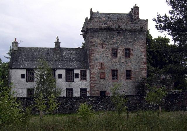
Hills Tower

Hills Tower is a sixteenth-century square tower house, with an adjoining eighteenth-century wing, near Dumfries in Scotland. Originally built around 1527...

Lochaber Loch

Lochaber Loch is a small, lowland freshwater loch that lies among steep-sided hills, approximately 4.5 mi (7.2 km) to the west of Dumfries, Scotland. The...

Lochrutton Loch

Lochrutton Loch is a large, lowland freshwater loch that lies to the west of Dumfries, Scotland. The loch trends from north to south and is 0.75 mi (1...

Nearby Amenities

Located within 500m of 55.027057,-3.706962
Power: pole
Lat/Long: 55.0267538/-3.6999638
Power: pole
Lat/Long: 55.026271/-3.7010193
Power: pole
Lat/Long: 55.0257744/-3.7021324
Power: pole
Lat/Long: 55.0254807/-3.7027869
Power: pole
Lat/Long: 55.0251671/-3.7038839
Power: pole
Lat/Long: 55.0248611/-3.7050158
Power: pole
Lat/Long: 55.0245444/-3.7060967
Power: pole
Lat/Long: 55.0242262/-3.7072071
Power: pole
Lat/Long: 55.0239017/-3.7083471
Power: pole
Lat/Long: 55.0235712/-3.7095165
Power: pole
Lat/Long: 55.023256/-3.7105358
Power: pole
Lat/Long: 55.0283001/-3.7144561
Power: pole
Lat/Long: 55.0279305/-3.7143076
Power: pole
Lat/Long: 55.0271985/-3.7139788
Power: pole
Lat/Long: 55.0262795/-3.7135854
Power: pole
Lat/Long: 55.0252818/-3.7131583
Power: pole
Lat/Long: 55.0245767/-3.7128565
Power: pole
Lat/Long: 55.0252978/-3.712778
Power: pole
Lat/Long: 55.0253599/-3.7112633
Power: pole
Lat/Long: 55.0257575/-3.7104339
Power: pole
Lat/Long: 55.0261697/-3.7095789
Power: pole
Lat/Long: 55.0265601/-3.7087452
Power: pole
Lat/Long: 55.0268811/-3.7080663
Power: pole
Lat/Long: 55.0230201/-3.7079433
Power: pole
Lat/Long: 55.0236817/-3.7064604
Power: pole
Lat/Long: 55.0243882/-3.7048396
Power: pole
Lat/Long: 55.0250753/-3.7032676
Power: pole
Lat/Long: 55.0257587/-3.701702
Power: pole
Lat/Long: 55.0261843/-3.7007601
Power: pole
Lat/Long: 55.0265832/-3.6998669
Power: pole
Lat/Long: 55.0255702/-3.7008173
Power: pole
Lat/Long: 55.0268373/-3.7001915
Power: pole
Lat/Long: 55.0271425/-3.7006052
Power: pole
Lat/Long: 55.0275584/-3.7005416
Power: pole
Lat/Long: 55.0279682/-3.70048
The data included in this document is from www.openstreetmap.org. The data is made available under ODbL.

Have you been to Lochanhead?

Leave your review of Lochanhead below (or comments, questions and feedback).