Klibreck

Settlement in Sutherland

Scotland

Klibreck

Strath Vagastie - Road (A836) approaching Altnaharra Looking north-eastward.
Strath Vagastie - Road (A836) approaching Altnaharra Credit: Peter Wood

The requested URL returned error: 429 Too Many Requests

If you have any feedback on the listing, please let us know in the comments section below.
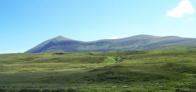
Klibreck Images

Images are sourced within 2km of 58.27536/-4.4108852 or Grid Reference NC5834. Thanks to Geograph Open Source API. All images are credited.

Strath Vagastie - Road (A836) approaching Altnaharra Looking north-eastward.
Strath Vagastie - Road (A836) approaching Altnaharra
Looking north-eastward.
Strath Vagastie - Road (A836) approaching Altnaharra Looking north-eastward.
Strath Vagastie - Road (A836) approaching Altnaharra
Looking north-eastward.
Road (B873) near to Loch Naver Looking eastward.
Road (B873) near to Loch Naver
Looking eastward.
Road (B873) beside the now felled Grummore Little Wood Looking north-eastward. The felling now allows good views of Loch Naver.
Road (B873) beside the now felled Grummore Little Wood
Looking north-eastward. The felling now allows good views of Loch Naver.
A shieling on the SE bank of Allt Creagach, east of Clebrig Farm. It is one of 5 in this pre-clearance shieling township, enclosed by a head dyke and there is also an Iron/Bronze Age hut circle on this site.
A shieling on the SE bank of Allt Creagach, east of Clebrig Farm.
It is one of 5 in this pre-clearance shieling township, enclosed by a head dyke and there is also an Iron/Bronze Age hut circle on this site.
Young woodland, Altnaharra Recently planted native trees in Strath Vagastie.
Young woodland, Altnaharra
Recently planted native trees in Strath Vagastie.
A836, Strath Vagastie Approaching Altnaharra.
A836, Strath Vagastie
Approaching Altnaharra.
Native woodland plantation, Altnaharra Young trees in Strath Vagastie.
Native woodland plantation, Altnaharra
Young trees in Strath Vagastie.
New house, Cnoc Vagastie A house has recently appeared in the conifer woods behind Altnaharra.
New house, Cnoc Vagastie
A house has recently appeared in the conifer woods behind Altnaharra.
Strath Vagastie moorland Gently sloping land under Ben Kilbreck.
Strath Vagastie moorland
Gently sloping land under Ben Kilbreck.
Altnaharra  and ice warning signs Appropriate road sign as Altnaharra often appears as the coldest weather station in the country and has a bit of a rivalry with Braemar.  Altnaharra is quite often the warmest place as well.
Altnaharra and ice warning signs
Appropriate road sign as Altnaharra often appears as the coldest weather station in the country and has a bit of a rivalry with Braemar. Altnaharra is quite often the warmest place as well.
Altnaharra Hotel The only refreshment stop for miles around - and it was closed!
Altnaharra Hotel
The only refreshment stop for miles around - and it was closed!
Entrance to Altnaharra Hotel Viewed from the A836.
Entrance to Altnaharra Hotel
Viewed from the A836.
River Mudale reaches Loch Naver at Altnaharra
Loch Naver Muir burning on the opposite shore of Loch Naver
Loch Naver
Muir burning on the opposite shore of Loch Naver
B873 and Loch Naver
B873 and Loch Naver
Vehicle Track on top of Druim Klibreck Coming from Klibreck Lodge, which is just visible. Ben Loyal and Loch Naver in the distance.
Vehicle Track on top of Druim Klibreck
Coming from Klibreck Lodge, which is just visible. Ben Loyal and Loch Naver in the distance.
Altnaharra Lodge policies and Loch Naver
Show me another place!

Klibreck is located at Grid Ref: NC5834 (Lat: 58.27536, Lng: -4.4108852)

Unitary Authority: Highland

Police Authority: Highlands and Islands

What 3 Words

///cubic.marmalade.single. Near Altnaharra, Highland

Nearby Locations

Klibreck

Related Wikis

Altnaharra

Altnaharra (Scottish Gaelic: Allt na h-Eirbhe) is a small hamlet in Sutherland in the Highland region of northern Scotland. The hamlet is on the A836 road...

Loch Naver

Loch Naver is a loch in the Farr parish in Sutherland in the Highland council area of northern Scotland. It is situated upon the B873 main road. Upon the...

Ben Klibreck

Ben Klibreck (Scottish Gaelic: Beinn Clìbric) is a Scottish mountain located in central Sutherland. It is an isolated mountain, rising above a large area...

Sutherland

Sutherland (Scottish Gaelic: Cataibh) is a historic county, registration county and lieutenancy area in the Highlands of Scotland. Its county town is Dornoch...

Nearby Amenities

Located within 500m of 58.27536,-4.4108852
Bus Stop
Klibreck
Naptan AtcoCode: 6700712860
Naptan Bearing: W
Naptan CommonName: Klibreck
Naptan Indicator: at Farm
Naptan Landmark: Klibreck Farm
Naptan NaptanCode: 45328352
Naptan Street: Farm Road
Naptan Verified: no
Source: naptan_import
Lat/Long: 58.2753243/-4.4119669
Klibreck
Name Gd: Clìbric
Place: hamlet
Lat/Long: 58.2758121/-4.4105517
Ford: yes
Lat/Long: 58.2746555/-4.4059005
Power: pole
Lat/Long: 58.2754282/-4.410509
Power: pole
Lat/Long: 58.2753949/-4.4106764
Power: pole
Lat/Long: 58.2753919/-4.4118182
Power: pole
Lat/Long: 58.2751395/-4.4132276
Power: pole
Lat/Long: 58.2752322/-4.4150478
Power: pole
Lat/Long: 58.2752803/-4.4158654
Power: pole
Lat/Long: 58.275356/-4.4171659
Power: pole
Lat/Long: 58.2754482/-4.4189199
Barrier: cattle_grid
Lat/Long: 58.2753327/-4.4124896
The data included in this document is from www.openstreetmap.org. The data is made available under ODbL.

Have you been to Klibreck?

Leave your review of Klibreck below (or comments, questions and feedback).