Kingmoor House

Settlement in Cumberland Carlisle

England

Kingmoor House

Benchmark on Park House Hotel Ordnance Survey flush bracket (serial identifier G4406) benchmark described on the Bench Mark Database at <span class="nowrap"><a title="www.bench-marks.org.uk/bm18635" rel="nofollow ugc noopener" href="http://www.bench-marks.org.uk/bm18635">Link</a><img style="margin-left:2px;" alt="External link" title="External link - shift click to open in new window" src="https://s1.geograph.org.uk/img/external.png" width="10" height="10"/></span>
Benchmark on Park House Hotel Credit: Roger Templeman

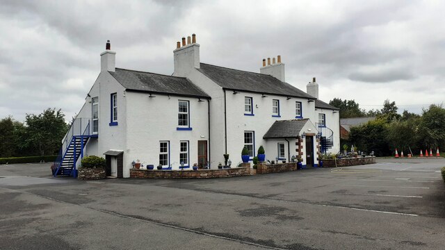
Kingmoor House is a historic mansion located in the county of Cumberland, England. Situated on the outskirts of the city of Carlisle, the house is set within picturesque grounds overlooking the scenic countryside.

Built in the early 19th century, Kingmoor House is a fine example of Georgian architecture. The building features a symmetrical façade adorned with elegant sash windows and a grand entrance portico. Its red brick exterior is complemented by beautiful stone detailing and a slate roof, presenting a striking appearance.

The mansion boasts a rich history, having served various purposes throughout the years. Originally built as a private residence for a wealthy local family, it later became a prestigious boarding school for young boys. During World War II, the house was converted into a military hospital, providing medical care for injured servicemen. Today, Kingmoor House has been transformed into a luxury hotel, offering guests a unique blend of historical charm and modern comforts.

The interior of Kingmoor House exudes opulence and grandeur. Its spacious rooms are tastefully decorated with period furnishings, creating an atmosphere of elegance and refinement. The hotel provides a range of luxurious amenities, including a fine dining restaurant, a spa, and beautifully manicured gardens for guests to enjoy.

With its rich history, stunning architecture, and idyllic setting, Kingmoor House is a true gem in the heart of Cumberland, offering visitors a memorable and indulgent experience.

If you have any feedback on the listing, please let us know in the comments section below.

Kingmoor House Images

Images are sourced within 2km of 54.916165/-2.9629081 or Grid Reference NY3858. Thanks to Geograph Open Source API. All images are credited.

Benchmark on Park House Hotel Ordnance Survey flush bracket (serial identifier G4406) benchmark described on the Bench Mark Database at <span class="nowrap"><a title="www.bench-marks.org.uk/bm18635" rel="nofollow ugc noopener" href="http://www.bench-marks.org.uk/bm18635">Link</a><img style="margin-left:2px;" alt="External link" title="External link - shift click to open in new window" src="https://s1.geograph.org.uk/img/external.png" width="10" height="10"/></span>
Benchmark on Park House Hotel
Ordnance Survey flush bracket (serial identifier G4406) benchmark described on the Bench Mark Database at LinkExternal link
Park House Hotel There is an Ordnance Survey flush bracket benchmark <a href="https://www.geograph.org.uk/photo/6936775">NY3860 : Benchmark on Park House Hotel</a> on the near corner, left hand face of the building
Park House Hotel
There is an Ordnance Survey flush bracket benchmark NY3860 : Benchmark on Park House Hotel on the near corner, left hand face of the building
Park House Hotel on SW side of Parkhouse Road
M6, southbound The M6 motorway runs from junction 19 of the M1 at the Catthorpe Interchange, near Rugby to the Gretna junction (J45). Here it becomes the A74(M) and M74 which continues to Glasgow.

The M6 is the longest motorway in the United Kingdom (232 miles) and one of the busiest. It incorporates the first length of motorway opened in the UK (the Preston bypass in 1958) and forms part of a motorway "Backbone of Britain", running north-south between London and Glasgow via the industrial north of England. It is also part of the east-west route between the Midlands and the east coast ports.
M6, southbound
The M6 motorway runs from junction 19 of the M1 at the Catthorpe Interchange, near Rugby to the Gretna junction (J45). Here it becomes the A74(M) and M74 which continues to Glasgow. The M6 is the longest motorway in the United Kingdom (232 miles) and one of the busiest. It incorporates the first length of motorway opened in the UK (the Preston bypass in 1958) and forms part of a motorway "Backbone of Britain", running north-south between London and Glasgow via the industrial north of England. It is also part of the east-west route between the Midlands and the east coast ports.
Entrance to Kingmoor (North) Nature Reserve Kingmoor is the oldest nature reserve in Cumbria, established in 1914. It was once a continuous strip of woodland over 2km long. The central section was felled in 1933 to build an airfield, which later became the Kingstown Industrial Estate. The remaining north and south reserves are today connected by a footpath which follows the route of the dismantled Waverley Railway Line. The reserve is managed by Carlisle City Council. (Information in this description taken from the board shown in the photo).
Entrance to Kingmoor (North) Nature Reserve
Kingmoor is the oldest nature reserve in Cumbria, established in 1914. It was once a continuous strip of woodland over 2km long. The central section was felled in 1933 to build an airfield, which later became the Kingstown Industrial Estate. The remaining north and south reserves are today connected by a footpath which follows the route of the dismantled Waverley Railway Line. The reserve is managed by Carlisle City Council. (Information in this description taken from the board shown in the photo).
The very end of the M6
Carlisle Kingmoor Railway Depot It's the end of the line for Class 31175
Carlisle Kingmoor Railway Depot
It's the end of the line for Class 31175
Motel, Kingstown, Carlisle Sandwiched between retail parks, a main road and the motorway.
Motel, Kingstown, Carlisle
Sandwiched between retail parks, a main road and the motorway.
Public Open Space, Moorville, Carlisle
St Peter's Church, Kingsmoor Next to a retail Park...
St Peter's Church, Kingsmoor
Next to a retail Park...
St Augustine's RC Church
Belah Primary School Flat roofed post-war construction.
Belah Primary School
Flat roofed post-war construction.
River Eden The River Caldew joins from right in the top of the shot.
River Eden
The River Caldew joins from right in the top of the shot.
St Kentigern's Church, Grinsdale Small country church accessible only by foot, with views over the River Eden.
St Kentigern's Church, Grinsdale
Small country church accessible only by foot, with views over the River Eden.
Town End, Grinsdale
Town End, Grinsdale
Kingstown Industrial Estate
Lowry Hill Road, Lowry Hill, Carlisle
River Eden Taken from the Hadrian's Wall Path.
River Eden
Taken from the Hadrian's Wall Path.
Show me another place!

Kingmoor House is located at Grid Ref: NY3858 (Lat: 54.916165, Lng: -2.9629081)

Administrative County: Cumbria

District: Carlisle

Police Authority: Cumbria

What 3 Words

///dull.only.look. Near Carlisle, Cumbria

Nearby Locations

Kingmoor House

Related Wikis

Carlisle Kingmoor TMD

Carlisle Kingmoor TMD is a railway traction maintenance depot situated in Carlisle, England. The depot is operated by the Direct Rail Services (DRS). The...

Etterby

Etterby is a former village in Cumbria, England. It is now a northwestern suburb of Carlisle, on the northern side of the River Eden. The Redfern Inn...

Kingmoor

Kingmoor is a civil parish in the City of Carlisle district of Cumbria, England, to the north west of Carlisle city centre. At the 2011 census it had a...

RAF Carlisle

RAF Carlisle (previously RAF Kingstown) was a Royal Air Force establishment, now closed after being used for a variety of roles over a period of fifty...

Austin Friars

Austin Friars is a coeducational private day school located in Carlisle, England. The Senior School provides secondary education for 350 boys and girls...

Milecastle 68

Milecastle 68 (Boomby Gill) is a conjectured milecastle of the Roman Hadrian's Wall. The site of the milecastle (adjacent to Boomby Gill) has been calculated...

Stainton, Kingmoor

Stainton is a hamlet in the Kingmoor parish of Cumberland, Cumbria, England. It is near the city of Carlisle. Circa 1870, it had a population of 63 as...

Grinsdale

Grinsdale is a village and former civil parish, now in the civil parish of Beaumont, in the Cumberland district, in the ceremonial county of Cumbria, England...

Nearby Amenities

Located within 500m of 54.916165,-2.9629081
Railway: switch
Lat/Long: 54.919971/-2.9599578
Railway: switch
Lat/Long: 54.9168082/-2.9658882
Man Made: tower
Lat/Long: 54.9171273/-2.9667627
Railway: switch
Lat/Long: 54.9163439/-2.9667758
Railway: switch
Lat/Long: 54.9167657/-2.967364
Railway: switch
Lat/Long: 54.9165801/-2.9671489
Railway: buffer_stop
Lat/Long: 54.9174372/-2.9666018
Railway: switch
Lat/Long: 54.9134101/-2.9629263
Railway: switch
Lat/Long: 54.9133686/-2.9631487
Railway: switch
Lat/Long: 54.9140361/-2.9634939
Railway: switch
Lat/Long: 54.9166004/-2.9656708
Railway: buffer_stop
Lat/Long: 54.9141574/-2.9635122
Railway: switch
Lat/Long: 54.9140402/-2.9635487
Railway: switch
Lat/Long: 54.9137259/-2.963177
DPD
Addr City: Carlisle
Addr Housenumber: Unit D
Addr Postcode: CA6 4RD
Addr Street: Kings Drive
Building: commercial
Lat/Long: 54.9201956/-2.9646465
Railway: switch
Lat/Long: 54.912541/-2.9625214
Stone Acorn
Artwork Type: sculpture
Tourism: artwork
Lat/Long: 54.9142069/-2.9561065
Natural: beach
Lat/Long: 54.9154073/-2.9571462
Railway: switch
Lat/Long: 54.9127685/-2.9627186
Railway: switch
Lat/Long: 54.9131001/-2.9629264
Kingmoor Junction
Railway: junction
Type: site
Lat/Long: 54.9135228/-2.963205
The data included in this document is from www.openstreetmap.org. The data is made available under ODbL.

Have you been to Kingmoor House?

Leave your review of Kingmoor House below (or comments, questions and feedback).