Holywell

Settlement in Lincolnshire South Kesteven

England

Holywell

25kV in the garden When this row of houses were built, the bit of land where the 25kV feed lines for the railway convert from overhead to underground was sold to the end house.
25kV in the garden Credit: Bob Harvey

Holywell is a small village located in the county of Lincolnshire, England. It sits approximately 6 miles south-east of the town of Grimsby and lies within the East Lindsey district. The village is situated on the edge of the Lincolnshire Wolds, an Area of Outstanding Natural Beauty, providing residents and visitors with picturesque views and a tranquil setting.

Holywell is known for its rich agricultural heritage, with vast fields and farmland surrounding the village. Most of the local economy is based on agriculture, with the cultivation of crops and livestock farming being the primary sources of income for many residents.

The village itself is relatively small, with a population of around 200 people. It consists of a few residential streets, a village hall, a church, and a primary school. The Holywell Church, dedicated to St. Mary, is a prominent feature of the village and dates back to the 13th century, boasting beautiful stained glass windows and intricate architectural details.

Holywell is a close-knit community with a strong sense of community spirit. The village holds various events throughout the year, including summer fairs and Christmas celebrations, which bring residents together and foster a sense of camaraderie.

For outdoor enthusiasts, Holywell offers ample opportunities for walking, cycling, and exploring the surrounding countryside. The nearby Lincolnshire Wolds provide numerous trails and pathways, allowing visitors to immerse themselves in the natural beauty of the area.

Overall, Holywell is a charming village that offers a peaceful and picturesque lifestyle, with a strong emphasis on agriculture and a close community spirit.

If you have any feedback on the listing, please let us know in the comments section below.
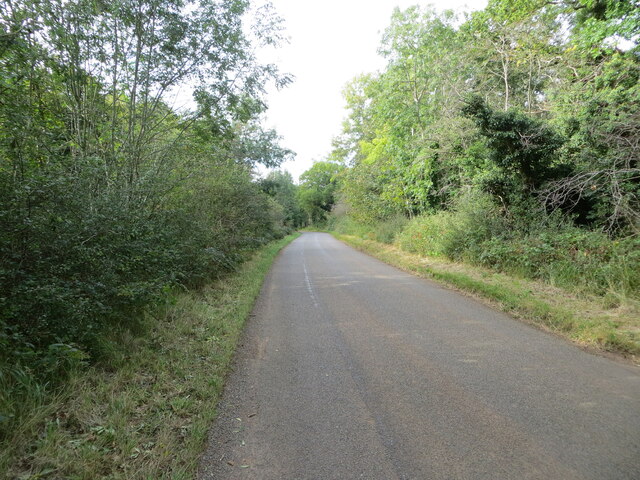
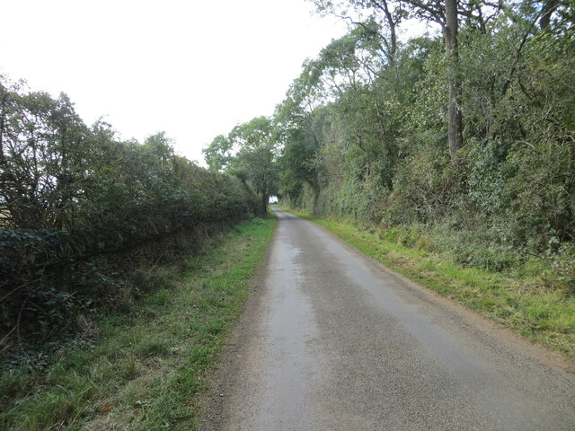
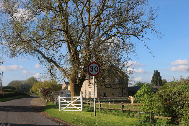
Holywell Images

Images are sourced within 2km of 52.731448/-0.51250115 or Grid Reference TF0015. Thanks to Geograph Open Source API. All images are credited.

25kV in the garden When this row of houses were built, the bit of land where the 25kV feed lines for the railway convert from overhead to underground was sold to the end house.
25kV in the garden
When this row of houses were built, the bit of land where the 25kV feed lines for the railway convert from overhead to underground was sold to the end house.
Physalis alkekengi The plant known as "Chinese Lantern" among garden centres is not native to the UK, and we are a little cold for it really.  But here it is growing in a hedgerow by the road, probably as a garden escapee.  There are individuals on the other side of the road too.
Physalis alkekengi
The plant known as "Chinese Lantern" among garden centres is not native to the UK, and we are a little cold for it really. But here it is growing in a hedgerow by the road, probably as a garden escapee. There are individuals on the other side of the road too.
Chinese Lanterns in the verge One of the patches of Physalis alkekengi growing in the roadside hedge. (see <a href="https://www.geograph.org.uk/photo/6946355">TF0117 : Physalis alkekengi</a>).
Chinese Lanterns in the verge
One of the patches of Physalis alkekengi growing in the roadside hedge. (see TF0117 : Physalis alkekengi).
Fibre to the Cabinet One of the cubicles erected to bring high-speed internet to the country.
Fibre to the Cabinet
One of the cubicles erected to bring high-speed internet to the country.
Beautiful Berries Hawthorn berries, or haws, in a hedge.
Beautiful Berries
Hawthorn berries, or haws, in a hedge.
Odder than it looks The use of overhead power distribution in these villages is not unusual.  But this one is.  What is it feeding?  It is in the garden of one of the 4 houses build on the former goods yard of Little Bytham station (itself an oddity, because it is in the parish of Careby, not Little Bytham).  The pole predates the houses by at least half a century.    It is one end of a run of  overhead wiring  in the village (three phases plus neutral) and all four wires are terminated on this pole to cables that go underground.  Normally that would be 3 phase and neutral, but it is not - it is two two-wire circuits (each of Live & Neutral) if you track the distribution past the pub to the end of the village.

This is the infeed end - hence the 4 terminations.  It appears to feed the rest of the village, but not the 4 houses here.

So where do we find two separate phases?  Why, on the poles in the background that bring two 25kV phases from Bourne West to the railway.  There must be, somewhere out of sight, a substation that steps that 25kV down to 240V for the older homes in the village - and perhaps the new ones, too, albeit underground.  See <a href="https://www.geograph.org.uk/photo/6946381">TF0117 : Warning label</a> which implies this assumption is correct.
Odder than it looks
The use of overhead power distribution in these villages is not unusual. But this one is. What is it feeding? It is in the garden of one of the 4 houses build on the former goods yard of Little Bytham station (itself an oddity, because it is in the parish of Careby, not Little Bytham). The pole predates the houses by at least half a century. It is one end of a run of overhead wiring in the village (three phases plus neutral) and all four wires are terminated on this pole to cables that go underground. Normally that would be 3 phase and neutral, but it is not - it is two two-wire circuits (each of Live & Neutral) if you track the distribution past the pub to the end of the village. This is the infeed end - hence the 4 terminations. It appears to feed the rest of the village, but not the 4 houses here. So where do we find two separate phases? Why, on the poles in the background that bring two 25kV phases from Bourne West to the railway. There must be, somewhere out of sight, a substation that steps that 25kV down to 240V for the older homes in the village - and perhaps the new ones, too, albeit underground. See TF0117 : Warning label which implies this assumption is correct.
Warning label The conjecture in <a href="https://www.geograph.org.uk/photo/6946370">TF0117 : Odder than it looks</a> that the village is fed via the supply to the railway system is amply borne out by this notice on the pole, which says
"East Midlands Electricity
If delivering shutdown cards to this location please contact Engineering Clerical immediately.
In the case of emergency for connection of supply contact British Rail on 01 340 2785 or 01 348 9542"

Both telephone numbers are, of course, decades out of date.
Warning label
The conjecture in TF0117 : Odder than it looks that the village is fed via the supply to the railway system is amply borne out by this notice on the pole, which says "East Midlands Electricity If delivering shutdown cards to this location please contact Engineering Clerical immediately. In the case of emergency for connection of supply contact British Rail on 01 340 2785 or 01 348 9542" Both telephone numbers are, of course, decades out of date.
Wiring details If you look at <a href="https://www.geograph.org.uk/photo/6945830">TF0117 : 25kV in the garden</a> and <a href="https://www.geograph.org.uk/photo/6945836">TF0117 : 25kV single phase</a> you will see that there are two groups of four wires coming from the power station at <a href="https://www.geograph.org.uk/photo/399639">TF0619 : Bourne West electricity sub-station</a>.  This is the 25kV supply for the railway overhead power.  

So here are four of the wires.  The top two are bridged together, and connected to a downfeed cable through the large insulator (<a href="https://www.geograph.org.uk/photo/6947644">TF0117 : Feed-through insulator</a>).  This is a single phase 25kV line.  The other two are also bridged together, and connected to a much lighter downfeed.  These are the Neutral, which is essentially at earth potential on the running rail.  

The other 25kV on the other set of posts is arranged in the same way.

Railway infeeds are complex, often providing a split-phase "supply" and "feeder" which combined with trackside autotransformers can reduce the longitudinal volt drop.  It is likely that these two are set up in the same way - one being the infeed and one the feeder, with 120 degree phase shift (a consequence of the conversion from three-phase at the substation).
Wiring details
If you look at TF0117 : 25kV in the garden and TF0117 : 25kV single phase you will see that there are two groups of four wires coming from the power station at TF0619 : Bourne West electricity sub-station. This is the 25kV supply for the railway overhead power. So here are four of the wires. The top two are bridged together, and connected to a downfeed cable through the large insulator (TF0117 : Feed-through insulator). This is a single phase 25kV line. The other two are also bridged together, and connected to a much lighter downfeed. These are the Neutral, which is essentially at earth potential on the running rail. The other 25kV on the other set of posts is arranged in the same way. Railway infeeds are complex, often providing a split-phase "supply" and "feeder" which combined with trackside autotransformers can reduce the longitudinal volt drop. It is likely that these two are set up in the same way - one being the infeed and one the feeder, with 120 degree phase shift (a consequence of the conversion from three-phase at the substation).
Feed-through insulator The large cable interface and feed-through insulator for the incoming 25kV seen in <a href="https://www.geograph.org.uk/photo/6947641">TF0117 : Wiring details</a>, showing how it is bonded to both the upper wires
Feed-through insulator
The large cable interface and feed-through insulator for the incoming 25kV seen in TF0117 : Wiring details, showing how it is bonded to both the upper wires
Station Road Looking north, where Station Road comes out from the arch of the former Midland and Great Northern line, which crossed the East Coast Main Line on an elevated bridge.
Station Road
Looking north, where Station Road comes out from the arch of the former Midland and Great Northern line, which crossed the East Coast Main Line on an elevated bridge.
Tree and hedge enclosed road at Little Warren Wood Looking north-westward.
Tree and hedge enclosed road at Little Warren Wood
Looking north-westward.
Hedge and tree enclosed minor road at Castle Dyke Looking south-westward.
Hedge and tree enclosed minor road at Castle Dyke
Looking south-westward.
Hedge enclosed minor road approaching The Grange Looking north-westward.
Hedge enclosed minor road approaching The Grange
Looking north-westward.
Willoughby Arms, Little Bytham Quite an imposing country pub which originally lay close to a railway station (<a href="https://www.geograph.org.uk/photo/4426796">TF0117 : The Willoughby Arms at Little Bytham, near Bourne, Lincolnshire</a>).
Willoughby Arms, Little Bytham
Quite an imposing country pub which originally lay close to a railway station (TF0117 : The Willoughby Arms at Little Bytham, near Bourne, Lincolnshire).
Country road near Clipsham (1)
Country road near Clipsham (2)
Holywell Road near Castle Bytham
Stamford Road, Careby
Show me another place!

Holywell is located at Grid Ref: TF0015 (Lat: 52.731448, Lng: -0.51250115)

Division: Parts of Kesteven

Administrative County: Lincolnshire

District: South Kesteven

Police Authority: Lincolnshire

What 3 Words

///whirlpool.thickens.maps. Near Pickworth, Rutland

Related Wikis

Holywell, Lincolnshire

Holywell is a tiny settlement in the civil parish of Careby Aunby and Holywell, in the South Kesteven district of Lincolnshire, England. It lies 5.5 miles...

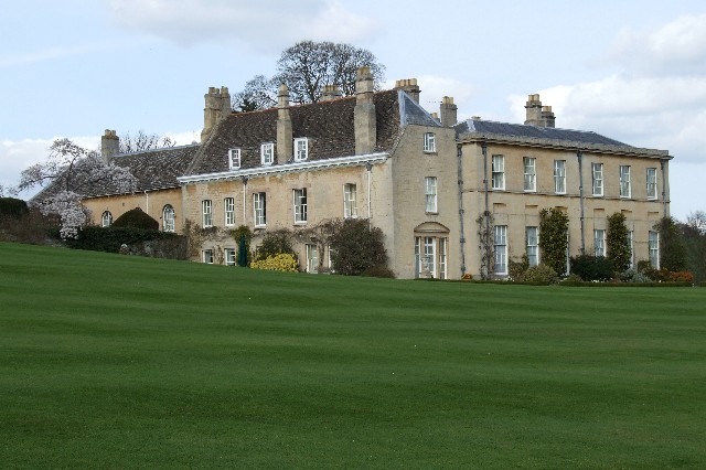
Holywell Hall, Lincolnshire

Holywell Hall is a building of historical significance in Lincolnshire and is listed on the English Heritage Register. The house is in the civil parish...

Careby Aunby and Holywell

Careby Aunby and Holywell is a civil parish in the district of South Kesteven, south-west Lincolnshire, in England. It stretches from the county border...

Lincolnshire Gate

Lincolnshire Gate is the name given to a corner in the road between Holywell, Lincolnshire and Pickworth, Rutland to the south-west of Castle Bytham, in...

Nearby Amenities

Located within 500m of 52.731448,-0.51250115
Bus Stop
Home Farm House
Naptan AtcoCode: 270000010076
Naptan Bearing: E
Naptan CommonName: Home Farm House
Naptan Indicator: adj
Naptan Landmark: Home Farm House
Naptan NaptanCode: linjgtgp
Naptan Street: Holywell
Naptan Verified: no
Source: naptan_import
Lat/Long: 52.7322714/-0.5153468
Bus Stop
Mill Farm
Naptan AtcoCode: 270000010077
Naptan Bearing: SW
Naptan CommonName: Mill Farm
Naptan Indicator: adj
Naptan Landmark: Mill Farm
Naptan NaptanCode: linjgtgt
Naptan Street: Holywell
Naptan Verified: no
Source: naptan_import
Lat/Long: 52.7314523/-0.5123978
Bus Stop
Mill Farm
Naptan AtcoCode: 270000010078
Naptan Bearing: NE
Naptan CommonName: Mill Farm
Naptan Indicator: opp
Naptan Landmark: Mill Farm
Naptan NaptanCode: linjgtgw
Naptan Street: Holywell
Naptan Verified: no
Source: naptan_import
Lat/Long: 52.7315693/-0.5124086
Bus Stop
Home Farm House
Naptan AtcoCode: 2700LH001309
Naptan Bearing: N
Naptan CommonName: Home Farm House
Naptan Indicator: opp
Naptan Landmark: Home Farm House
Naptan NaptanCode: linajpaj
Naptan Street: Holywell
Naptan Verified: no
Source: naptan_import
Lat/Long: 52.7323026/-0.5156864
Keeper's Lodge
Place: isolated_dwelling
Source: Bing
Lat/Long: 52.7314422/-0.5066544
Mill Farm
Place: farm
Source: Bing
Lat/Long: 52.7312857/-0.5116009
Access: agricultural
Barrier: cattle_grid
Foot: yes
Horse: yes
Lat/Long: 52.7340754/-0.5148894
Access: agricultural
Barrier: cattle_grid
Foot: yes
Horse: yes
Lat/Long: 52.7343512/-0.5144938
The data included in this document is from www.openstreetmap.org. The data is made available under ODbL.

Have you been to Holywell?

Leave your review of Holywell below (or comments, questions and feedback).