High Possil

Settlement in Lanarkshire

Scotland

High Possil

Entrance to Bishopbriggs railway station Looking up a ramp leading from Bishopbriggs Cross to the railway station.
Entrance to Bishopbriggs railway station Credit: Andrew Reid

High Possil is a residential area located in the city of Glasgow, within the historic county of Lanarkshire, Scotland. Situated approximately four miles northwest of the city center, High Possil is bordered by Possilpark to the south and the affluent area of Maryhill to the east.

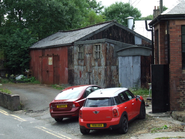
The area predominantly consists of mid-20th-century housing estates, with a mix of both public and private housing. The architecture is mostly comprised of traditional tenement buildings, which were popular during the period of industrial expansion in Scotland. High Possil offers a range of housing options, catering to diverse socio-economic backgrounds.

Despite being a predominantly residential area, High Possil has a few amenities to serve its residents. There are a few local shops, convenience stores, and small businesses scattered throughout the neighborhood. The area also boasts a community center, which offers various activities and services for the local residents.

For outdoor enthusiasts, High Possil benefits from its proximity to the nearby Possil Marsh, a nature reserve known for its wetland habitat and diverse wildlife. The marsh provides opportunities for leisurely walks, bird watching, and enjoying nature.

Transport links in High Possil are well-developed, with several bus routes connecting the area to the city center and surrounding regions. Additionally, nearby Maryhill train station provides access to further destinations in and around Glasgow.

Overall, High Possil is a residential community with a blend of housing options and convenient transport links, offering a peaceful suburban lifestyle within close proximity to Glasgow's amenities.

If you have any feedback on the listing, please let us know in the comments section below.

High Possil Images

Images are sourced within 2km of 55.899954/-4.2552437 or Grid Reference NS5969. Thanks to Geograph Open Source API. All images are credited.

Entrance to Bishopbriggs railway station Looking up a ramp leading from Bishopbriggs Cross to the railway station.
Entrance to Bishopbriggs railway station
Looking up a ramp leading from Bishopbriggs Cross to the railway station.
Bus on Kirkintilloch Road (A803) First Glasgow bus on Kirkintilloch Road (A803), having just left Bishopbriggs Cross with service 27B to Glasgow, Buchanan Bus Station.
Bus on Kirkintilloch Road (A803)
First Glasgow bus on Kirkintilloch Road (A803), having just left Bishopbriggs Cross with service 27B to Glasgow, Buchanan Bus Station.
Police Station, Bishopbriggs On Kirkintilloch Road.
Police Station, Bishopbriggs
On Kirkintilloch Road.
Bishopbriggs railway station Opened in 1842 by the Edinburgh and Glasgow Railway. View south west towards Glasgow Queen Street station.
Bishopbriggs railway station
Opened in 1842 by the Edinburgh and Glasgow Railway. View south west towards Glasgow Queen Street station.
Bishopbriggs railway station, Dunbartonshire Opened in 1842 by the Edinburgh and Glasgow Railway, later part of the North British Railway.
View north east towards Lenzie and Edinburgh just prior to electrification. For the same view some three years later, see <a href="https://www.geograph.org.uk/photo/5293335">NS6170 : Bishopbriggs railway station, Dunbartonshire</a>.
Bishopbriggs railway station, Dunbartonshire
Opened in 1842 by the Edinburgh and Glasgow Railway, later part of the North British Railway. View north east towards Lenzie and Edinburgh just prior to electrification. For the same view some three years later, see NS6170 : Bishopbriggs railway station, Dunbartonshire.
Bishopbriggs railway station Class 158 train number 158734 heading north out of the station.
Bishopbriggs railway station
Class 158 train number 158734 heading north out of the station.
Kirkintilloch Road Viewed from Bishopbriggs railway station.
Kirkintilloch Road
Viewed from Bishopbriggs railway station.
Bishopbriggs railway station Looking north from Platform 1.

Cmmpare with the same scene in 1961 <a href="https://www.geograph.org.uk/photo/1805647">NS6170 : Bishopbriggs Station</a>.
Bishopbriggs railway station
Looking north from Platform 1. Cmmpare with the same scene in 1961 NS6170 : Bishopbriggs Station.
Bishopbriggs railway station Looking south from Platform 1.
Bishopbriggs railway station
Looking south from Platform 1.
Crowhill Road A corrugated iron building near the railway line. See also <a href="https://www.geograph.org.uk/photo/3625016">NS6070 : Corrugated iron building</a>.
Crowhill Road
A corrugated iron building near the railway line. See also NS6070 : Corrugated iron building.
Bishopbriggs War Memorial A WWI and WWII memorial at the corner of Kirkintilloch Road and Kenmure Avenue.
Bishopbriggs War Memorial
A WWI and WWII memorial at the corner of Kirkintilloch Road and Kenmure Avenue.
Bishopbriggs railway station The entrance on Springfield Road at the junction of Kirkintilloch Road.
Bishopbriggs railway station
The entrance on Springfield Road at the junction of Kirkintilloch Road.
Bishopbriggs town centre The Cross Court off Kirkintiloch Road.
Bishopbriggs town centre
The Cross Court off Kirkintiloch Road.
Corrugated iron building On Crowhill road, near the railway station. See also <a href="https://www.geograph.org.uk/photo/3623122">NS6070 : Crowhill Road</a>.
Corrugated iron building
On Crowhill road, near the railway station. See also NS6070 : Crowhill Road.
Bishopbriggs railway station Looking south from the station footbridge on a Saturday afternoon.
Bishopbriggs railway station
Looking south from the station footbridge on a Saturday afternoon.
Bishopbriggs rooftops The view south from the railway station footbridge.
Bishopbriggs rooftops
The view south from the railway station footbridge.
Bishopbriggs Police Station Viewed from the railway station footbridge.
Bishopbriggs Police Station
Viewed from the railway station footbridge.
Corner of Kirkintilloch Rd & Springfield Road, Bishopbriggs
Show me another place!

High Possil is located at Grid Ref: NS5969 (Lat: 55.899954, Lng: -4.2552437)

Unitary Authority: City of Glasgow

Police Authority: Greater Glasgow

What 3 Words

///calls.souk.soaks. Near Bishopbriggs, East Dunbartonshire

Nearby Locations

Milton High Possil

Related Wikis

Milton, Glasgow

Milton is a district in the Scottish city of Glasgow, situated north of the River Clyde. The housing scheme is about 2+1⁄2 miles (4 kilometres) north of...
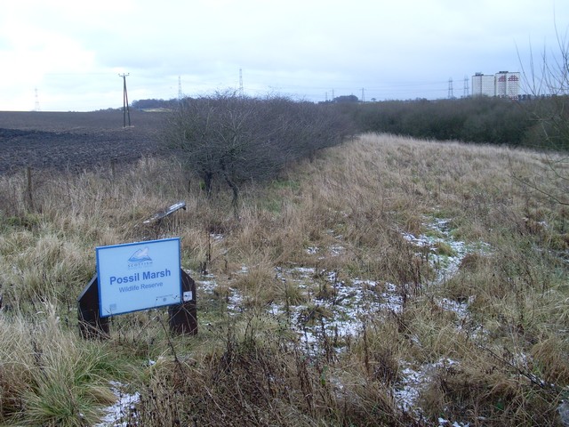
Possil Marsh

Possil Marsh is a nature reserve and Site of Special Scientific Interest, of both flora and fauna, within the city of Glasgow, Scotland. The reserve was...

Possil railway station

Possil railway station was situated on Balmore Road, in the north of Glasgow, Scotland and served the Possilpark and Parkhouse areas of the city. ��2...

Lambhill

Lambhill is an area in the city of Glasgow, Scotland. It is situated north of the River Clyde, approximately 2 miles (3.2 km) north of the city centre...

Nearby Amenities

Located within 500m of 55.899954,-4.2552437
Mini Roundabout
Direction: clockwise
Lat/Long: 55.9005075/-4.2521622
Power: tower
Lat/Long: 55.9038009/-4.2561873
Power: tower
Lat/Long: 55.9037661/-4.2574803
Power: tower
Source: bing
Lat/Long: 55.9024575/-4.2603892
Power: tower
Source: bing
Lat/Long: 55.9025511/-4.2586355
Noexit: yes
Lat/Long: 55.9012676/-4.2590679
Noexit: yes
Lat/Long: 55.9013554/-4.2590629
Bus Stop
Milton, Liddesdale Road/ Birsay Road
Naptan AtcoCode: 60901055
Naptan Bearing: SW
Naptan CommonName: Liddesdale Road
Naptan Indicator: at 128
Naptan Landmark: Birsay Road
Naptan NaptanCode: 45232343
Naptan Street: Liddesdale Road
Ref: 60901055
Source: survey
Lat/Long: 55.8968054/-4.2567253
Bus Stop
Milton, Liddesdale Road/ Birsay Road
Naptan AtcoCode: 60903830
Naptan Bearing: NE
Naptan CommonName: Liddesdale Road
Naptan Indicator: opp 128
Naptan Landmark: Birsay Road
Naptan NaptanCode: 45273796
Naptan Street: Liddesdale Road
Ref: 60903830
Source: survey
Lat/Long: 55.8969361/-4.2567784
Barrier: cycle_barrier
Lat/Long: 55.9002458/-4.2611531
Tourism: viewpoint
Lat/Long: 55.9011546/-4.2616816
Gatehouse
Entrance: yes
Lat/Long: 55.8990283/-4.2605054
Reception
Entrance: main
Lat/Long: 55.8985857/-4.2608195
Shelter
Shelter Type: smoking
Lat/Long: 55.8990731/-4.2605536
Library
Milton Library and Learning Centre
Wikidata: Q62665128
Lat/Long: 55.8965482/-4.254104
Cafe
Lat/Long: 55.896683/-4.2540707
Crossing
Crossing: uncontrolled
Crossing Island: yes
Lat/Long: 55.8971088/-4.2542044
Barrier: bollard
Lat/Long: 55.8971509/-4.2510562
Bus Stop
Milton, Liddesdale Road/ Castlebay Street
Naptan AtcoCode: 60901047
Naptan Bearing: W
Naptan CommonName: St Augustines Primary School
Naptan Indicator: before
Naptan Landmark: Castlebay Street
Naptan NaptanCode: 45234238
Naptan Street: Liddesdale Road
Ref: 60901047
Lat/Long: 55.89695/-4.2525
Bus Stop
Milton, Liddesdale Road/ Castlebay Street
Naptan AtcoCode: 60901048
Naptan Bearing: E
Naptan CommonName: St Augustines Primary School
Naptan Indicator: Opp
Naptan Landmark: Castlebay Street
Naptan NaptanCode: 45239572
Naptan Street: Liddesdale Road
Ref: 60901048
Lat/Long: 55.8970343/-4.25027
Bus Stop
Milton, Liddesdale Road/ Castlebay Street
Naptan AtcoCode: 60901045
Naptan Bearing: W
Naptan CommonName: Castlebay Street
Naptan Indicator: Opp
Naptan Landmark: Castlebay Street
Naptan NaptanCode: 45234874
Naptan Street: Liddesdale Road
Ref: 60901045
Lat/Long: 55.89707/-4.25465
Bus Stop
Milton, Liddesdale Road/ Castlebay Street
Naptan AtcoCode: 60901046
Naptan Bearing: E
Naptan CommonName: Castlebay Street
Naptan Indicator: after
Naptan Landmark: Castlebay Street
Naptan NaptanCode: 45234289
Naptan Street: Liddesdale Road
Ref: 60901046
Lat/Long: 55.89714/-4.25402
Bus Stop
Milton, Skerray Street/ Scaraway Street
Naptan AtcoCode: 60901041
Naptan Bearing: SW
Naptan CommonName: Milton Bus Terminus
Naptan Indicator: at
Naptan Landmark: Scaraway Street
Naptan NaptanCode: 45243426
Naptan Street: Skerray Street
Ref: 60901041
Lat/Long: 55.90076/-4.25212
Place Of Worship
Egilsay Church
Denomination: protestant
Religion: christian
Lat/Long: 55.8989233/-4.2524041
High Possil
Place: quarter
Lat/Long: 55.8988255/-4.2579789
Bicycle Parking
Bicycle Parking: stands
Capacity: 44
Covered: no
Fee: no
Lat/Long: 55.8967144/-4.2537216
Generator Method: photovoltaic
Generator Output Electricity: yes
Generator Source: solar
Generator Type: solar_photovoltaic_panel
Power: generator
Lat/Long: 55.89641/-4.2551971
Generator Method: photovoltaic
Generator Output Electricity: yes
Generator Source: solar
Generator Type: solar_photovoltaic_panel
Power: generator
Lat/Long: 55.900906/-4.2545369
Generator Method: photovoltaic
Generator Output Electricity: yes
Generator Source: solar
Generator Type: solar_photovoltaic_panel
Power: generator
Lat/Long: 55.9018027/-4.251513
Generator Method: photovoltaic
Generator Output Electricity: yes
Generator Source: solar
Generator Type: solar_photovoltaic_panel
Power: generator
Lat/Long: 55.9018158/-4.2514103
Generator Method: photovoltaic
Generator Output Electricity: yes
Generator Source: solar
Generator Type: solar_photovoltaic_panel
Power: generator
Lat/Long: 55.9014948/-4.2477549
Generator Method: photovoltaic
Generator Output Electricity: yes
Generator Source: solar
Generator Type: solar_photovoltaic_panel
Power: generator
Lat/Long: 55.9017672/-4.2480008
Generator Method: photovoltaic
Generator Output Electricity: yes
Generator Source: solar
Generator Type: solar_photovoltaic_panel
Power: generator
Lat/Long: 55.9017854/-4.2481533
Generator Method: photovoltaic
Generator Output Electricity: yes
Generator Source: solar
Generator Type: solar_photovoltaic_panel
Power: generator
Lat/Long: 55.901831/-4.2486452
Generator Method: photovoltaic
Generator Output Electricity: yes
Generator Source: solar
Generator Type: solar_photovoltaic_panel
Power: generator
Lat/Long: 55.9018356/-4.2487855
Generator Method: photovoltaic
Generator Output Electricity: yes
Generator Source: solar
Generator Type: solar_photovoltaic_panel
Power: generator
Lat/Long: 55.9021398/-4.2486777
Generator Method: photovoltaic
Generator Output Electricity: yes
Generator Source: solar
Generator Type: solar_photovoltaic_panel
Power: generator
Lat/Long: 55.8979348/-4.253586
Generator Method: photovoltaic
Generator Output Electricity: yes
Generator Source: solar
Generator Type: solar_photovoltaic_panel
Power: generator
Lat/Long: 55.8978537/-4.2532638
Generator Method: photovoltaic
Generator Output Electricity: yes
Generator Source: solar
Generator Type: solar_photovoltaic_panel
Power: generator
Lat/Long: 55.8976769/-4.2530046
Generator Method: photovoltaic
Generator Output Electricity: yes
Generator Source: solar
Generator Type: solar_photovoltaic_panel
Power: generator
Lat/Long: 55.8979165/-4.2526894
Generator Method: photovoltaic
Generator Output Electricity: yes
Generator Source: solar
Generator Type: solar_photovoltaic_panel
Power: generator
Lat/Long: 55.8979296/-4.2526053
Generator Method: photovoltaic
Generator Output Electricity: yes
Generator Source: solar
Generator Type: solar_photovoltaic_panel
Power: generator
Lat/Long: 55.8976809/-4.252603
Generator Method: photovoltaic
Generator Output Electricity: yes
Generator Source: solar
Generator Type: solar_photovoltaic_panel
Power: generator
Lat/Long: 55.8976782/-4.2524442
Generator Method: photovoltaic
Generator Output Electricity: yes
Generator Source: solar
Generator Type: solar_photovoltaic_panel
Power: generator
Lat/Long: 55.8979322/-4.252192
Generator Method: photovoltaic
Generator Output Electricity: yes
Generator Source: solar
Generator Type: solar_photovoltaic_panel
Power: generator
Lat/Long: 55.8983033/-4.2519912
Generator Method: photovoltaic
Generator Output Electricity: yes
Generator Source: solar
Generator Type: solar_photovoltaic_panel
Power: generator
Lat/Long: 55.8983465/-4.2512795
Generator Method: photovoltaic
Generator Output Electricity: yes
Generator Source: solar
Generator Type: solar_photovoltaic_panel
Power: generator
Lat/Long: 55.8983188/-4.250651
Generator Method: photovoltaic
Generator Output Electricity: yes
Generator Source: solar
Generator Type: solar_photovoltaic_panel
Power: generator
Lat/Long: 55.898438/-4.2501703
Generator Method: photovoltaic
Generator Output Electricity: yes
Generator Source: solar
Generator Type: solar_photovoltaic_panel
Power: generator
Lat/Long: 55.8979803/-4.2502689
Generator Method: photovoltaic
Generator Output Electricity: yes
Generator Source: solar
Generator Type: solar_photovoltaic_panel
Power: generator
Lat/Long: 55.8977263/-4.2505154
Generator Method: photovoltaic
Generator Output Electricity: yes
Generator Source: solar
Generator Type: solar_photovoltaic_panel
Power: generator
Lat/Long: 55.8977298/-4.250232
Generator Method: photovoltaic
Generator Output Electricity: yes
Generator Source: solar
Generator Type: solar_photovoltaic_panel
Power: generator
Lat/Long: 55.8976866/-4.2511224
Generator Method: photovoltaic
Generator Output Electricity: yes
Generator Source: solar
Generator Type: solar_photovoltaic_panel
Power: generator
Lat/Long: 55.8976572/-4.2516308
Generator Method: photovoltaic
Generator Output Electricity: yes
Generator Source: solar
Generator Type: solar_photovoltaic_panel
Power: generator
Lat/Long: 55.8983447/-4.2483494
Generator Method: photovoltaic
Generator Output Electricity: yes
Generator Source: solar
Generator Type: solar_photovoltaic_panel
Power: generator
Lat/Long: 55.8983137/-4.2480105
Generator Method: photovoltaic
Generator Output Electricity: yes
Generator Source: solar
Generator Type: solar_photovoltaic_panel
Power: generator
Lat/Long: 55.8983206/-4.2479243
Generator Method: photovoltaic
Generator Output Electricity: yes
Generator Source: solar
Generator Type: solar_photovoltaic_panel
Power: generator
Lat/Long: 55.8980286/-4.2483125
Generator Method: photovoltaic
Generator Output Electricity: yes
Generator Source: solar
Generator Type: solar_photovoltaic_panel
Power: generator
Lat/Long: 55.8980718/-4.2480013
Generator Method: photovoltaic
Generator Output Electricity: yes
Generator Source: solar
Generator Type: solar_photovoltaic_panel
Power: generator
Lat/Long: 55.8978939/-4.2487931
Kindergarten
Milton Community Nursery
Website: https://blogs.glowscotland.org.uk/gc/miltoncommunitynursery/
Lat/Long: 55.8967087/-4.2543
Generator Method: photovoltaic
Generator Output Electricity: yes
Generator Source: solar
Generator Type: solar_photovoltaic_panel
Power: generator
Lat/Long: 55.8988285/-4.2518212
Generator Method: photovoltaic
Generator Output Electricity: yes
Generator Source: solar
Generator Type: solar_photovoltaic_panel
Power: generator
Lat/Long: 55.8988459/-4.2504821
Generator Method: photovoltaic
Generator Output Electricity: yes
Generator Source: solar
Generator Type: solar_photovoltaic_panel
Power: generator
Lat/Long: 55.8988189/-4.252026
The data included in this document is from www.openstreetmap.org. The data is made available under ODbL.

Have you been to High Possil?

Leave your review of High Possil below (or comments, questions and feedback).